
 The map’s green circle mile markers
are modern highway exit numbers
used for current location reference.
 The map’s yellow rectangle mile markers show path of YT and distance to state’s west border. Click the corresponding number in text for directions and more information.
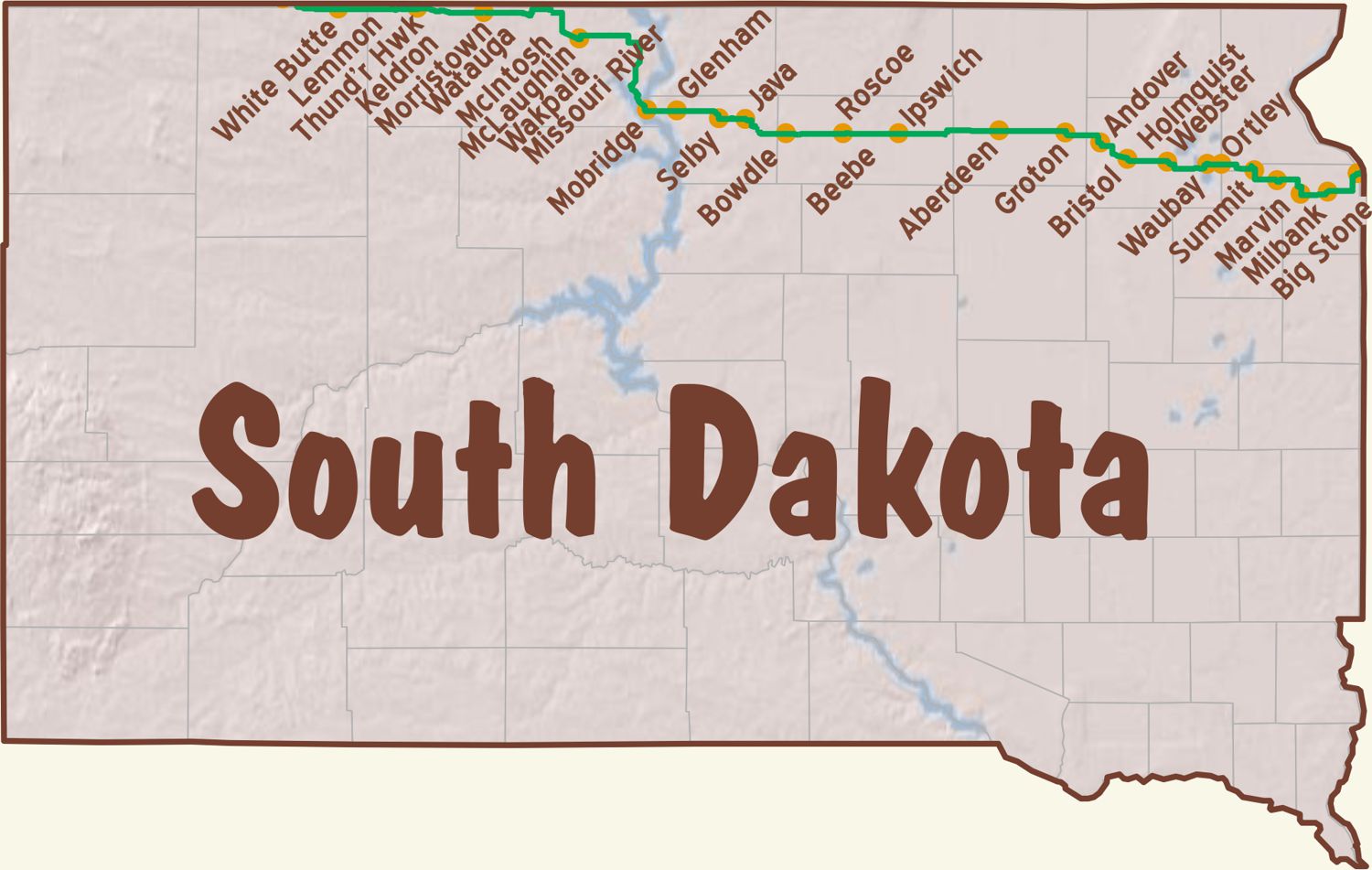
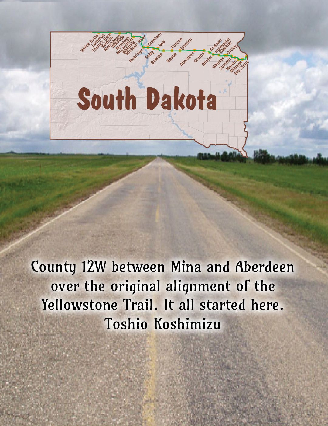
For Directions, click the South Dakota (SD-) State YTA Mile Marker Numbers (below) linking you to a real-time map.
 SD-000.0 N. Dakota/S. Dakota Line
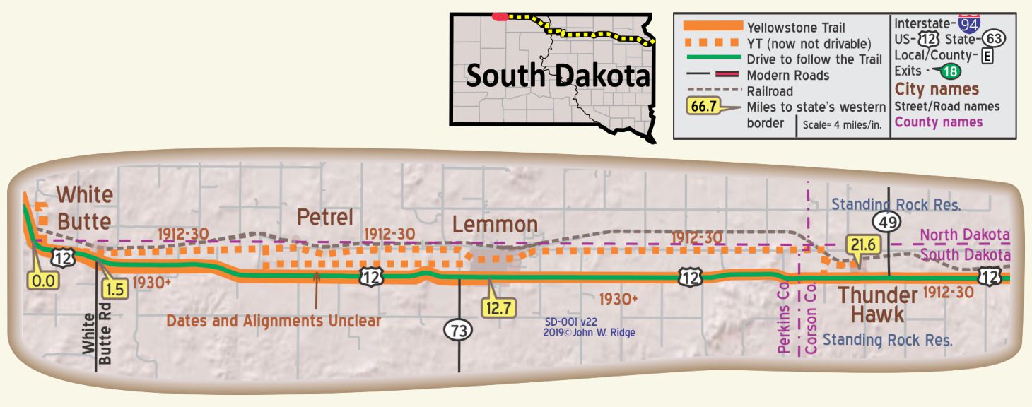
SD-001.5 White Butte
(85 pop.), the last town in South Dakota on US 12, is a typical Western movie village, its few houses evidently built without much idea of the town’s coherence. Since it is a railroad town with a favorable location as a stock shipping point, it is a familiar sight to see cows or sheep dodging behind houses as the herds are driven to the stockyards for their long journey to market. WPA-SD*
A village; rooms; small garage; free camp space. C. A. SAMPSON’S GARAGE leads; has good name and good mechanics. Labor $1.25; ph. 15 until 11 p. m. MH-1928*
NOTE: Before US 12 was given its modern alignment the highway ran directly north of White Butte, on a now abandoned road.
White Butte is the first town in South Dakota going east and the last going west on the Yellowstone Trail (now US 12). It was founded in 1909 and named after the white limestone butte nearby.
In Yellowstone Trail days it was a stock shipping point with many businesses to support the ranches in the area. When the Milwaukee Road railroad left, White Butte shrank, like many other small towns abandoned by railroads.
SD-012.7 Lemmon
(2,567 alt., 1,785 pop.), was named for “Ed” Lemmon, pioneer and cattleman who for years was foreman of the large L7 cattle outfit. The town is the trade center for a large territory in both North and South Dakota, which produces grain, cattle, horses, and sheep. Thus, it is one of the few towns in the United States where cattlemen, sheepmen and farmers meet on a common ground. Situated on the North Dakota Line, part of the town is actually in the adjoining State.
Attempts at farming in the immediate vicinity have resulted in much distress during recent drought years, although the soil is exceptionally fertile. WPA-SD*
pop. 1,300;YELLOWSTONE HOTEL is now best; 4 rooms with r. w. All rooms to be made modern; sgl. $1.25; dbl. $2.
LEMMON AUTO CO. Ford, large and modern; has best mechanics for all cars. Open to 10 p.m. labor $1-$1.25; ph. 29 for tow car. MH-1928*
When you get to Lemmon you know you are on the prairie – the Great Plains. Windswept and glorious in the sunlight, one can just imagine the early explorers and wagon trains lumbering slowly, pushing our nation west. Lemmon is near Grand River National Grassland and Cedar River National Grassland and the area is characterized by rolling hills dominated by mixed grass prairie with scattered outcrops of badlands.
“Lemmon and surrounding area offers a way of life you can’t find anywhere else. It is the way of life of the Northern Plains, of the prairie and of the Yellowstone Trail.” Highway 12 Guide 2005.
Lemmon figured large in the story of the Yellowstone Trail. Oct. 9-10, 1912 Good Roads folks invited the Ipswich founding group to Lemmon to form an association. It was here that ByLaws were written and the long moniker of “Twin Cities-Aberdeen-Yellowstone Park Trail” was hung on their invention. It would be shortened to “Yellowstone Trail” later. Lemmon would remain a faithful contributor to the Association for its entire 18 year run.
It is also the starting point of a cross-state run in a Studebaker Six in May of 1915 by Trail founder Joe Parmley. His run ended at Big Stone City, 349 South Dakota miles, 800 pounds of South Dakota mud and 16 hours later. See Trail Tale: Parmley’s Trip, page <?>.
On US 12 (Yellowstone Trail) the Grand River Museum displays an interesting mix of local homesteaders’ lives along with geological and paleontological artifacts such as dinosaur bones of T-Rex Sue and a triceratops. Depictions of Native American culture, cattle branding and Lewis and Clark’s trek all bear credibility because of the proximity of those events to Lemmon. An interesting statue of a triceratops stands outside of the museum. It is made entirely of scrap metal!
On Main St. is the amazing world’s largest Petrified Wood Park and Museum. It covers a whole city block, is outdoors and is free. You probably have not ever seen so much petrified wood in one spot before. It looks like the TV town of Bedrock with Fred Flinstone popping up among these “rocks”. There is a 300 ton castle with turrets, also round balls, monuments with Yellowstone Trail printed on them, and cones tall and small. All man-made. Look closely and you will find dinosaur tracks and fossils. The “castle,” built entirely of petrified logs, contains the gift shop where you can buy – what else? petrified wood bits.
SD-021.6 Thunder Hawk
(100 pop.), has a general store where on Saturdays commodities, politics, and gossip are exchanged over the cracker and pickle barrels. WPA-SD*
Thunder Hawk is on the western edge of the Standing Rock Reservation.
The STANDING ROCK INDIAN RESERVATION, covers the eastern half of Corson Co. in South Dakota, and extends into North Dakota, with the Agency at Fort Yates, N. Dak.
There are 3,828 Sioux Indians on the reservation roll, 2,565 of which are listed as full-bloods by the agency superintendent. The native bands within the Sioux Tribe on this reservation are: Hunkpapas, Yanktonai, Teton, Minneconjou, Itazibeo, Oohenupa, Sihasapa, Ogalala, Sicungu, and Isanyati. The native language is used by 90 percent of the people over 40, and by half the children of pre-school age, little by school children. Rodeos are held at irregular intervals during the summer months. WPA-SD*
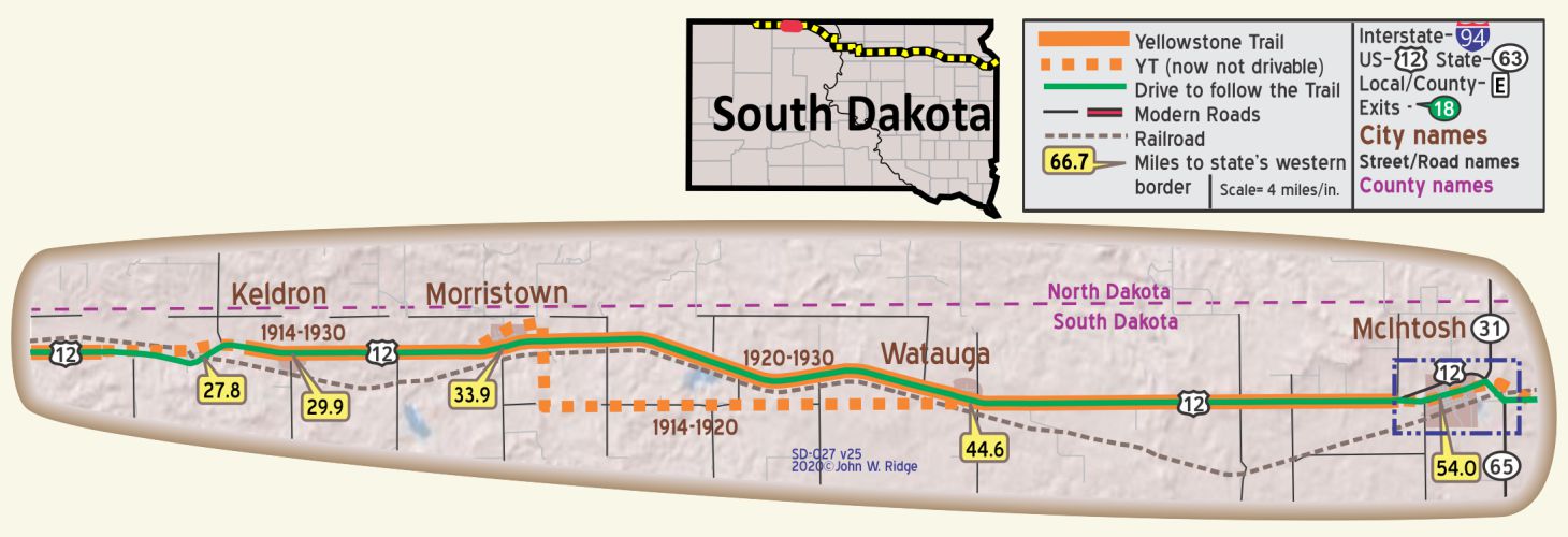
SD-033.9 Morristown
(2,240 alt.,.235 pop.), named for the C-7 ranch proprietor, Nels Morris. It supplies the surrounding ranchers with such supplies as they do not get from mail order houses.
A village in a wheat and flax growing district; three garages. Stadel Garage leads. No camp. MH-1928*
SD-044.6 Watauga
pop. 100; wheat, flax and barley are the principal crops. Fair country hotel. Simon-Thompsen Garage is best. Open camp space. MH-1928*
Watauga, Corson County, is located 10 miles west of McIntosh, the county seat. It is on the main line of the Chicago, Milwaukee, and St. Paul Railway and on the transcontinental highway, the Yellowstone Trail. The community surrounding this prosperous village is noted for its mammoth growth of prairie grass, affording pasture and hay for thousands of stock, and with rich deposits of Lignite coal which can be purchased at from $1.00 to $2.00 per ton. The community has RFD, telephone lines, and radio receiving sets. Excerpted from Watauga Commercial Club publication 1923.
On the corner of 2nd Ave. E and US 12, the northwest corner, you will see another small “hoodoo” painted yellow with black vertical lettering of the Yellowstone Trail. It is across 2nd Ave. from Brenda’s Tumbleweed Café at 22870 US 12.
Four miles east of Wautaga on the north side of the road about 20 feet from the road is a bullet-shaped hoodoo Yellowstone Trail marker painted white with a yellow stripe.
SD-054.0 McIntosh
Between Mcintosh and Lemmon the rolling country breaks into occasional sharp buttes and grassless mud flats. This land was once the paradise of cattlemen; it still is, but in a different sense. The cattleman must rent his land today; yesterday it belonged to anyone or no one. Here, where there are few towns and the roads are impassable in wet seasons, the temptation to go to town is less. Men and women are wind-burned the year around, and children are virtually raised in the saddle. WPA-SD*
Wheat and sheep raising are the main sources of revenue. Boots Cafe is best. H. & C. Motors is reputed good. Mcintosh Motor Co., for Fords. Free camp space, cold showers. MH-1928*
There was a Trail Garage there in 1924.
Native Americans of Standing Rock Reservation put on shows for tourists in Yellowstone Trail days.
McIntosh is the county seat of Corson County which contains much of the Standing Rock Reservation. Present county officers were much interested in the Yellowstone Trail. Sadly the offices burned down, preventing further research there. The Reservation also straddles the border into Sioux County, North Dakota. Lakota Sioux Indians populate the South Dakota portion. It is the sixth-largest reservation in land area in the United States with a land area of 3,571.9 square miles. McIntosh was laid out and parcels sold in 1910 by the Milwaukee Land Company, a division of the Chicago, Milwaukee, St. Paul and Pacific (The Milwaukee Road) Railway.
McIntosh, as a boom town, marched to the rhythm of the railroad: pool halls and cafes never closed. In 1912 there was [sic] six stalls for engines in the yard and six being built. Three hundred houses stood south of the railroad track where railroad workers lived. Many houses in town with a spare room had a boarder. When the First World War came, three shifts went on in the yards. In the thirties people were forced to turn to the railroad for coal – bits stolen, mostly. Stock was shipped out of the country by rail for decades. The railroads have changed now. High speed steel and diesel trains carry big loads across country without a stop. Morristown World June 1958.
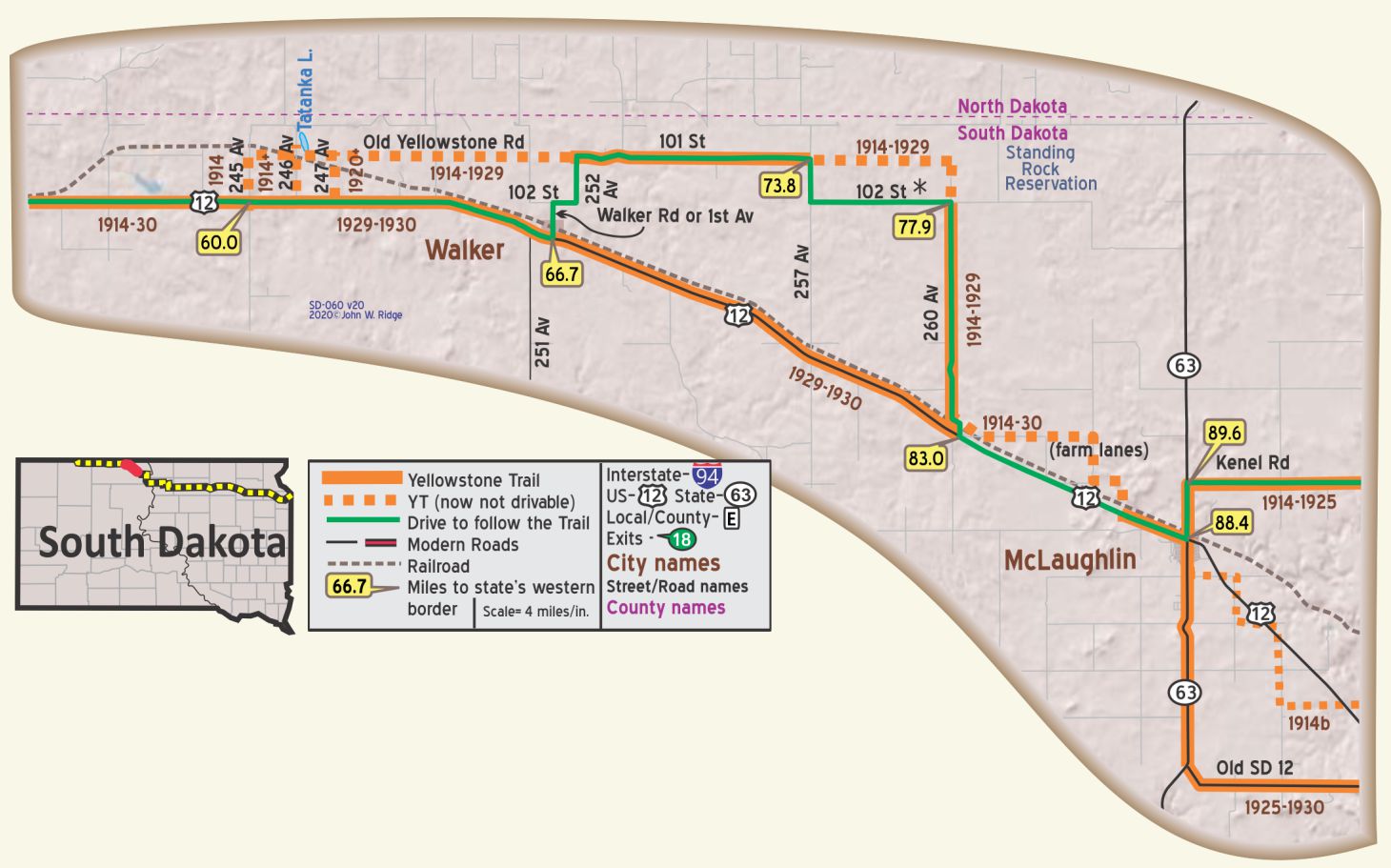 SD-088.4 McLaughlin
Is the center of Standing Rock Indian Reservation which is the home of 5,000 Sioux Indians. Indian tent village 10 miles south on river; visitors permitted. This is one of the largest tractor farming areas in the west; wheat and flax farms as large as 2,000 to 5,000 acres are found between here and Mcintosh. Eat at Dew Drop Inn; best and clean rooms at Mrs.Wehrfritz, $1 a person. Free camp on hill only fair. JEWETT GARAGE has good name; open 24 hrs.; labor $1;phone 12 for road service. MH-1928*
(1,633 alt., 200 pop.), is a settlement of whites and Indians. The one-street village, of frame buildings and a bright new community hall, has board sidewalks. A modern, brick schoolhouse contrasts with log cabins and tents in the wooded outskirts of the village. WPA-SD*
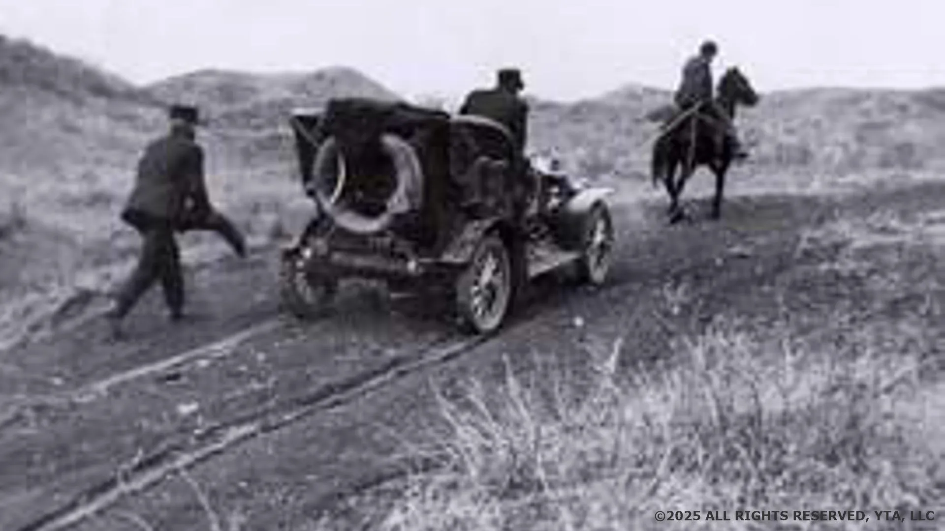
Routing the Trail through Corson County was always a problem for the Yellowstone Trail Association, almost the whole of the county being on the Standing Rock Reservation. In 1916 Joe Parmley and others laid out a route. Before that the Trail ran along unimproved prairie trails. As late as 1938, US 12/Corson County boosters were begging for oiling their road, evidence that the Trail was still not much improved.
Traveling from the west, the land gently descends from the uplands as the road enters the Missouri River valley. Trees are scarce, visible only lining the length of creeks or planted in yards.
312 Main St., three blocks south of US 12 (Yellowstone Trail). Major James McLaughlin Heritage Center. You could stop to see if this interesting, little museum is open. It might not be. The Center was named for James McLaughlin, Indian Agent for the Standing Rock Reservation in the late 1800s. The small Center features a Major James McLaughlin family display and historical documents, early local settlers’ memorabilia and hand made Indian articles and art.
The route east of Walker is gravel and not recommended when wet. There are no gas stations or other services in this area other than in McLaughlin. The eastern part of 102 St. is little used with minimum maintenance. 257 Ave. is also Co. 13-2. 101 St. is also Co. 2. 260 Ave. is a narrow lane and an “authentic experience.” Old SD 12 is made of packed clay.
 SD-119.1 Wakpala
Wakpala is on the Native American Scenic Byway which runs from the northernmost North Dakota point of the Standing Rock Reservation past Fort Yates, North Dakota, and south through Corson County, South Dakota highway 1806 and south for 90 miles. Most of the Byway is on Native American reservation land. Thus, the present Byway followed about 18 miles of the early route of the Yellowstone Trail in eastern Corson County.
WAYSIDE – Travel south from Wakpala on Co. 1806, the Lewis and Clark Highway, for about 12 scenic miles and you will come to the Sitting Bull Grave Site, and a little further, the Sakagawea (Sakakawea) Monument. Or you can get there from Mobridge by going six miles west of Mobridge on U.S. 12 and four miles south on 1806. This is the final resting place of the great Sioux warrior.
Sitting Bull is mostly remembered today as a brave and wise leading figure in battles against whites, in the Battle of the Little Bighorn in which Custer died, and as a leader of the Hunkpapa Sioux. He is also remembered as part of the famous Buffalo Bill Cody’s Wild West Show. He was killed in 1890 on the Standing Rock Reservation on which stands this memorial. He was buried at Fort Yates, North Dakota. Sixty-three years passed. The grave at Fort Yates had been neglected and poorly marked. With permission of his relatives, a delegation of men from Mobridge Chamber of Commerce quietly arrived at Fort Yates in April, 1953, and disinterred the bones. He now rests in a steel vault with 20 tons of concrete on top of it on a bluff overlooking the Missouri River/Lake Oahe. Sculptor Korczak Ziolkowski, who began the Crazy Horse Mountain carving near Mount Rushmore, agreed to sculpt the bust of Sitting Bull. GPS: 45.51696, -100.48521.
Variously spelled Sacagawea, Sakakawea. and apparently 15 other ways, not one with a “j”, is a memorial to Lewis and Clark’s Indian guide. Controversy still whirls around her life story. Her birth date of 1787 meets with less controversy than the date and place of her death and burial.
Tribute is paid to “Bird Woman” with this monument which is a few miles away from the Missouri River site where Lewis and Clark once camped. Oddly, the memorial looks more like the Washington monument obelisk in Washington D.C. than a Native American design.
GPS: 45.51588 -100.48811.
Information from November 10, 2011 Native American Culture: “The First Scout” by Dakota Wind.
https://thefirstscout.blogspot.com/
SD-129.5 Mobridge
As the division headquarters for the Pacific extension of the Milwaukee Railroad, the town grew rapidly. A large railroad yard still remains. An excellent collection of Indian relics taken from Ankara village sites near Mobridge is displayed on Main St. In Mobridge are seen ranchers with ten-gallon hats and cowboy boots, and Indians in overalls or shawls. WPA-SD*
At Yellowstone Trail and Main St.; pop. 3,000; the live trade center for a big territory, also an important freight and passenger division. Best meals at Pierce Cafe, lunch 40c. City camp, 25c.
BROWN PALACE HOTEL all rooms outside, light and with toilet; dbl. $2.75-$3; with bath $3.75-$4. Cafe in conn.
PIERCE HOTEL is second best; 29 rooms with r. w. and steam heat, 2 with bath; sgl. $1.25; dbl. $2; with bath $3.
S. ERDAHL in Buick Garage on Trail, is reputed best mechanics; labor $1.25; emergency night work; ph. 410 for 24 hr. road service.
DARLING AUTO CO., Ford, is large and modern. Phone 440 until 10 p. m. MH-1928*
There was a Yellowstone Garage in 1924.
In May of 1906 work began on the railroad bridge which was to become “the mightiest bridge built anywhere across the Missouri” according to the 1981 Mobridge Tribune 75th Anniversary Special Diamond Jubilee Section. There was no town until the railroad company established one three miles south of the bridge. They used the railroad telegrapher’s abbreviation for Mo. bridge as the name of the new town. It became a major division headquarters with a 26-stall roundhouse. Like other railroad towns, folks moved to the rhythm of the railroad, its major employer. The bridge was replaced over the wider Lake Oahe, created in 1962 now spanning 2349 feet of water.
Mobridge (Bridge City) is surrounded on three sides by Lake Oahe which was created in 1962 by a Dam on the Missouri River near Pierre. The lake swallowed the much narrower Missouri River. Thus, today one sees huge bays and sweeping bridges and a small town making the most of its watery kingdom by attracting tourists and fishermen to this “Walleye Capital.” As you look at maps in this book and read about ferry boats and a 1924 auto bridge at Mobridge, you must remember that the distance a bridge had to cover before 1924 was about 1800 feet, not the vast expanse of Lake Oahe created in 1962. For a discussion of Mobridge’s ferry boats, the 1924 bridge, and the Yellowstone Trail, see Trail Tale: Missouri River, page <?>. See also the map on page <?>.
Even today people in Mobridge and area are aware of the Yellowstone Trail. There is an area school athletic conference called the Yellowstone Trail Conference, a ranching association called Yellowstone Trail Livestock Improvement Association and even a quilting group called Yellowstone Trail Quilters. Into the 1970s there was still a Trail Café and a Yellowstone Trail pheasant farm. A Yellowstone Trail Café again appeared in the early 2000s.
1820 W Grand Crossing (west US 12; the Yellowstone Trail). Klein Museum. European and Indian cultures are both on display in western antiques and in Sioux and Arikara Indian artifacts and beadwork. Typical early scenes such as a post office, dentist’s office, and railroad memorabilia are displayed. Living history tours provide hands-on events for children.
212 Main St. The Mobridge Auditorium (Howe Arena). Ten murals, 16’ tall X 20’ wide, depicting Sioux Indian ceremonies and history decorate the interior walls. Voice narratives accompany viewing. All were painted by the late Oscar Howe, world renowned artist and South Dakota Native American. The auditorium is on the National Register of Historic Places.
301 N Main St. The Brown Palace Hotel. Now called the Brown Palace Apartments. Opened in 1918 by A. H. Brown who said, “The people of Mobridge would have a beautiful hotel, as well as public restrooms on Main Street.” It took around three years to complete the three-story 110-room building. It also contained a barbershop, lunch room, dining room, and eight apartments. Today, the hotel’s exterior appearance remains much the same as in 1918. This building represents an important piece of Mobridge’s history.
WAYSIDE – A walking trail along the shores of Lake Oahe is located just south of town.
River bluffs and rugged buttes to the west across Lake Oahe, and rolling plains to the east seem to protect Mobridge down at lake level. One can imagine buffalo by the thousands on the prairie grasslands. One can imagine Mobridge as the big cattle shipping site which it once was. A packing plant was needed, but people objected to the possible smell. “People all came from small farms. It’s funny how that smell is bad when you move to Main St.,” said resident Mrs. Dale Shillingstad.
 SD-150.7 Selby
Cattle and horse raising is carried on extensively as well as farming.
Although Selby is several miles from the Missouri River, nearly every spring one resident builds a houseboat, pulls it to the river, floats down to New Orleans for the winter, sells his boat and returns to build another. WPA-SD*
The crest of the Missouri River breaks is reached in the area, with a view of the river and bottom-land stretching N. and S., fringed with cedar, willow, and cottonwood trees. Here farming and livestock-raising are carried on together, and proposals for large irrigation projects are made annually. WPA-SD*
pop. 800; a wheat area; many German inhabitants. Free camp space on Trail.
HOTEL AUBURN is clean. Dbl. $2; meals 50c. MANKE AND TAYLOR GARAGE, is best equipped; owner a fine mechanic. Labor $1.20; open late. MH-1928*
This is the county seat of Walworth County. It wasn’t easy, though. Bangor had been the county seat for 20 years, but Selby won a Circuit Court judgement and was the county seat briefly. After several differing court judgements, Selby finally won and a court house was built there in 1913.
4304 4th Ave. County Court House. Go take a look at the 100 year old building which looks like a midwestern court house should. Built about the time the Yellowstone Trail reached Selby.
One hundred years ago travelers on the Yellowstone Trail may have camped overnight at the Selby City Park. It’s still free today.
Corner of Scranton and Main Sts. (SD 103/Yellowstone Trail) Chesky Auto Co. You can’t miss it. The name is prominently displayed over the entry. In 1917 a frame garage was erected on the site, called the Yellowstone Garage. In 1925 Wm. G. Chesky bought it and by 1928 it became Chesky Garage in the brick building that you see. Today it is used only for storage.
3409 Main St. Selby Opera House. Built at $12,000 in 1908. Traveling theater companies put on plays, movies were shown, the Commercial Club was formed there and today, at over 100 years, it is still going strong.
SD-158.4 Java
pop. 330; grain and stock are chief support; country hotel. Spiry & Sons Garage is good Ford agency.
MH-1928*
The little town had an intriguing name. Story has it that it was named for a really good cup of coffee at a track-side shack for railroad crews. The town was a railroad town settled by people of German and Russian descent in 1900 and got its streets graveled in 1925 in a novel way: money was transferred out of the “liquor fund” on a monthly basis and utilized for the betterment of the streets and walks.
No doubt one of those streets was Main Street, the Yellowstone Trail.
The “stair step” route of the Yellowstone Trail that you see south of Java on the map is a good example of the way roads were routed in the early 1900s. Farm section lines determined the route.
By 2000 most of the buildings were dismantled and folks had moved away, allowing time for prairie grass to begin to return, crowding over the once-bustling town.
SD-173.4 Bowdle
pop. 900; mostly German; rooms but no hotel; Bowdle Sales Co. Garage leads. Good meals at Carlsons. Free camp with cook house. MH-1928*
There was a Yellowstone Trail Garage in 1924.
Bowdle was settled by farmers of German and Russian heritage and named for Alex Bowdle, a townsite agent for the Milwaukee Road railway. Bowdle became a large grain milling and shipping center because that was the terminus of the railway. Like its neighbors, Bowdle had a municipal light plant in 1911 giving unreliable and limited service until 1925 when the Northern States Power Company stabilized the utility.
NOTE – Near Java, as elsewhere, the first route of the YT followed the least muddy section line right-of-way. Some became good roads, others became farmers’ fields. Several combinations of section lines were used here, apparently.
NOTE – The YT route just north and west of Selby is now gravel, perhaps poor. A Clason SD map of the period indicates that the route north of Selby ran one mile east of and parallel to 370 Ave.(From “Clason on disk”).
 SD-189.0 Roscoe
(1,826 alt., 540 pop.), is a trade center for a farming community, not unlike the small towns of the movies, with pool halls, tall red grain elevators, general stores, square houses, and large frame churches.
WPA-SD*
The Homestead Act of 1862 drew many immigrants to the promised 160 acres of land at $1.25 per acre. There were farms, but no surveyed town until 1883.
Roscoe was the first home of Joe Parmley, founder of the Yellowstone Trail. He arrived from Wisconsin in April, 1883, having walked the 40 miles from the railroad end in Aberdeen. Upon his arrival, he joined fellow tenters (there was no town there) Sam Basford and Chas Morgan. The three named the “town” Roscoe after Morgan’s father’s friend, U.S. Senator Roscoe Conkling of New York. Parmley and Henry Huck established a newspaper, the Roscoe Herald, on Huck’s printing press. Parmley moved his house (literally, with horses and rollers) to Ipswich when the train arrived there in 1885. He continued to publish the paper until 1910 when it became the Ipswich Tribune after Parmley had moved to that city. For more on Parmley’s life and the Yellowstone Trail, see Trail Tale: Parmley, page <?>.
SD-195.5 Beebe
Marcus P. Beebe founded the town and was its first banker. He was a friend of Joe Parmley of Ipswich and was a “founding father” of the Yellowstone Trail Association in 1912, and served as its interim president to February 1913 when a first election was held.
The Milwaukee Road railroad arrived in 1886 and served the community until 1982. Once a thriving town with hotels, a post office, churches, and schools, the town of Beebe served as a protection for people traveling the Yellowstone Trail in the winter blizzards. Today there isn’t much left of Beebe to see as folks started to move away in 1942.
SD-204 Ipswich
The promotion of the Yellowstone Trail (US 12) from “Plymouth Rock to Puget Sound” was begun at Ipswich by Joseph W. Parmley, and the organization, now known as the U. S. No. 12 Association, still maintains its national headquarters here. A World War memorial arch spans the highway, bearing the name of the Yellowstone Trail and its founder. WPA-SD*
pop. 943; a grain and stock raising center. The St. James Hotel is not modern, but best. Yellowstone Garage reputed good. Motor Sales Co. is open late. Camp 35c at serv. sta. on highway. WPA-SD*
Ipswich is known as the “Home of the Yellowstone Trail” because it was there that resident Joe Parmley founded the Yellowstone Trail Association. Parts of the Yellowstone Trail in Ipswich (8th St. to Broadway) finally got paved with concrete in 1937, but the town itself still has side streets of gravel.
During the summer of 1883 the Chicago, Milwaukee, and St. Paul Railroad built 26 miles west of Aberdeen and stopped. The name of the stopping point was selected by a Milwaukee Road official who was from Ipswich, England. Thirty years later Ipswich was “one of the important shipping points on the Milwaukee Road.”
If you visit Ipswich in June you may have the luck of viewing their “Trail Days” a weekend of celebrating the Yellowstone Trail which they have had, on and off, for the last 100 years. Parades, pie contests, bull riding (real bulls), and much more.
319 Fourth St. J. W. Parmley Historical Home and Museum. It is on the National Register of Historical Places. The museum was the original home of J. W. Parmley, built in 1919. The home is built of cement, brick and plaster, thought to withstand the many prairie fires that occurred during the early days of Ipswich. Parmley had suffered a house lost to fire before. Active in the Anti-Saloon League, Parmley suffered the loss of his house to a suspected pro-saloon arsonist. There are even a cement bath tub and cement floors. There are two stone fireplaces, which include stones and fossils from all over the world, collected by Parmley during his extensive travels.
115 Main St. The Parmley Land Office Museum. Joe Parmley was a land and abstract agent. He sold land to settlers, knew much about agriculture and was a “dreamer” in that he saw and worked for projects to better people’s lives. His land office is in a 1900 stone block building. It offers a large map of the entire Yellowstone Trail, views of early Ipswich businesses, and yet another fireplace built of interesting memorabilia and rocks. For a more full story of Parmley’s life, see Trail Tale: Parmley, page <?>.
Between 8th and 9th streets along US 12, the Yellowstone Trail, there is a memorial arch standing in Collier Park. That arch has quite a history and is worth seeing.
120 Main St. Marcus P. Beebe Memorial Library. Beebe was a banker, philanthropist, and early Trail Association booster.Two other buildings of note are the Marcus Beebe home across the street from the Parmley Home Museum and the First Baptist Church. They are all built of fine fieldstone of the Dakota Territory. The library has a Medicine or Prayer Rock in its front lawn. Found in Mobridge, this petroglyph on a glacial boulder contains the hand prints of a Native American and was considered a symbol of great power.
 SD-217.9 Mina
US 12 crosses the neck of Mina Lake, formed by damming Dry Run Creek. Construction of the dam was started by private subscriptions from Aberdeen and Ipswich residents who wanted a recreational site. It was completed with the help of the State Game and Fish Department and Federal relief agencies. The lake is stocked with game fish, and is a State game reserve. Another arm of the horseshoe-shaped lake is crossed over a rock spillway. WPA-SD*
Mina Lake (Lake Parmley) Recreation Area, now a state park, is a lovely recreational site with camping, swimming, boating, picnicking and hiking. The lake is horseshoe shaped with the land between the two arms the state park. There was no lake there in Yellowstone Trail days. The Trail crossed one arm of Snake Creek, a wet slough north of Mina, and a bridge crossed the other arm. In 1930 Joe Parmley and others were looking for a way to bring in additional recreational water because a nearby lake was almost dry. Parmley suggested a dam at the fork of Snake Creek. By 1934 that dam was completed and a lake of 20 to 30 feet deep was created. Today, US 12 runs on top of that Parmley Dam. The lake is officially named Lake Parmley, but in general parlance it is Mina Lake. The dam is called Parmley Dam.
June 19, 1913 Aberdeen Daily News:
Edmunds County has appropriated $800 towards the construction of an eight foot concrete culvert near Mina. This culvert will be of reinforced concrete of the arch design, and will be the first piece of concrete work put in along the Trail in this section.
SD-231.6 Aberdeen
pop 18,000 BB-1921*
At the Milwaukee R.R. stockyards, trainloads of cattle, sheep, and hogs from North and South Dakota and Montana are unloaded for rest, water, and feed on their way to packing centers farther east. From 200 to 2,000 carloads of stock pass through the yards each month during the fall shipping season. The yards are interesting by night as well as by day, when trains unload under bright lights. WPA-SD*
Business center of northern South Dakota; sometimes called the “Hub City” of the Dakotas. It is situated in the center of the James River valley which is the largest artesian water basin in the world. Road information at the live C. of C, also at booth on Trail. Ward Coffee Shop is best, lunch 50c; Comb’s Cafe is Amer. and popular. The Melgaard Tourist Camp, about one mile south, is in a beautiful park covered with Cottonwood trees, 50c per night. MH-1928*
[Note: Melgaard Park is still there today.]
It became known as “Hub City” because five rail lines converged there. Five historic depots are located throughout the city.
It was the home of Hal Cooley, the consummate PR man who was the secretary of the Aberdeen Commercial Club when he gravitated to the Yellowstone Trail Association as General Manager in 1916 for 14 tumultuous years. For more about this energetic, creative dynamo, see Trail Tale: The “Boys”, page <?>.
114 South Lincoln St. The Yellowstone Trail Association Headquarters 1916-1918. The headquarters site was at Parmley’s Land Office in Ipswich from 1912 to 1916. Parmley then placed the day-to-day affairs in Cooley’s hands and the headquarters moved to Aberdeen. It remained there for two years before moving in 1918 to more visible quarters in Minneapolis. The Aberdeen office remained as one of 15 “information bureaus” which acted like today’s AAA in giving out maps and information about the Trail.
21 S Main St. Dacotah Prairie Museum. Aberdeen’s prodigious past is displayed in pioneer life, wildlife, Native American culture, and railroads. A prairie diorama, children’s exhibit, and the Telephone Pioneer Museum are also there. This 1889 building is on the National Register of Historic Places.
1 N Main St. The Chicago, Milwaukee, St. Paul and Pacific (The Milwaukee Road) Station is completely restored, showing its 1911 Craftsman/Prairie style influences of the early 20th century. It houses the Convention and Visitors Bureau which is well aware of the Yellowstone Trail. It is on the National Register of Historic Places.
104 S Main St. Alonzo Ward Hotel. Alonzo R. Ward built his hotel in 1928. Some 76 years later, in 2004, the building was restored. Ninety of the original hotel rooms were converted into 15 luxury condominiums on floors 3-6. The original restaurant, coffee shop, lobby, and commercial spaces were all restored. The exterior still looks like a 1928 building which original Yellowstone Trail travelers would recognize. It is on the National Register of Historic Places.
Highlands Historic District – Comprised of 17 historic homes built between 1885 and 1952. The area is called “highlands” because the land is about three feet higher than the rest of the town. In flat South Dakota, three feet commands notice. They are mainly on North Main St. between 12th and 15th Aves. NE and S Kline.
415 S Main St. Capitol Theatre. It was built in 1926 as a premier vaudeville/silent movie house. Today it is the home of Aberdeen Community Theatre April through November. It also shares its stage with Northern State University productions. From December through March newly released Hollywood films are shown.
Sixth Ave. (Yellowstone Trail) between Dakota and Jackson Sts. is Nicollet Park, Aberdeen’s smallest park at three-tenths of an acre. It was originally named for Nicollet Ave. which is now Sixth Ave. “Tourists made use of this park from the time the Yellowstone Trail went past it,” according to the 1980 Brown County History.
Between 17th Ave. and Melgaard Ave. (19th Ave.) end of State St. is Melgaard Park. Twenty-five acres were donated to the city in 1909 by Andrew Melgaard. It was frequented by Trail travelers. In 1924 the Commercial Club put up 65 signs along the Yellowstone Trail and the Sunshine Highway directing tourists to the park. Today, after 100 years, it still features campgrounds, but also basketball and volleyball courts, a skate park, and aquatic center.
WAYSIDE – Wylie Park. While Wylie Park is not on the Trail, it is something fun to see along US 281 in northwest Aberdeen. Beyond expectations for a city park, it has over 200 acres of water sports, go-karts, a zoo, and a large campground. Storybook Land and Land of Oz are there, two large areas featuring themes from the Wizard of Oz. L. Frank Baum, author of the Oz stories, lived in Aberdeen from 1888 to 1891 and the community has never forgotten him.
During the heyday of the “trolley,” or interurban electric light-rail cars, there were often parks at the end of the line to give people a reason to ride. Wylie Park was one of them. For a more full description of trolleys, see Trail Tale: Trolleys, page <?>.
July 23, 1920 Aberdeen American:
TRAIL OFFICE HAS MANY INQUIRIES
Last week more people inquired at the local Yellowstone Trail Information Bureau than inquired at the Fort Wayne, Minneapolis, Missoula, Miles City, or Spokane Bureaus. Milwaukee Bureau was the only one along the entire trail that had more tourists ask for information than did the Aberdeen office.
 SD-239.9 Bath
Between Groton and Aberdeen US 12 passes through the James River valley, one of the richest farming areas in the Middle West, the soil of which is a rich black loam, a deposit of the glacial period. Around each farm is a grove of trees, reminiscent of homestead days when a claim could be had for planting 20 acres in trees. WPA-SD*
The Bath Meteorite. John Paul Gries in Roadside Geology of South Dakota (1996) reports that a meteorite fell near Bath in 1892.
He describes it colorfully thus:
People watched in amazement as a meteorite that weighed 46 pounds fell near Bath in a blazing fireball on the afternoon of August 19, 1892. Searchers had no difficulty finding it on the silty surface of the sediments deposited in Glacial Lake Dakota, which are certifiably free of rocks. Most of the meteorite is stony, composed of chondrules about the size and shape of bird shot with some metallic nickel-iron. Several of the large museums in the United States have spectacular polished slices on display, as does the British Museum of Natural History.
SD-250.6 Groton
(pop. 1,200, alt. 1,301 ft.), is an attractive little city situated in the center of a level, alluvial plain that in prehistoric times was the bed of the glacial lake Dakota. More than 1,000,000 bushels of wheat have been marketed in Groton in a single season. It is also fast becoming famous as a purebred Holstein center. Pheasant hunting is especially good along the James River, and the bright-colored ring-neck pheasants are to be seen any day, any season, somewhere along the highway. BB1921-9*
GROTON, at bank; pop. 1,300; in center of the richest farm land in South Dakota. Country hotel. Ford Garage is best. Fine free camp in city park. MH-1928*
210 3rd St. N. Small white Trinity Episcopal Church was built in 1884 and restored in 2009. Yellowstone Trail travelers must surely have stopped at this lovely, peaceful place.
SD-262.9 Andover
(alt. 1,475. Pop 324) was first known as Station 88 by railroad graders, but when the town was platted in 1881 it took its present name from Andover, Mass. This market town for a rich farming region has a large, old-fashioned hotel, the Waldorf. WPA-SD*
The Waldorf Hotel was a memorable place. Its size stood out in this small community and it was clearly visible from the Yellowstone Trail (US 12). It is no more today. In 2000, residents of Andover tried to restore the 1902 “best hotel between Aberdeen and Minneapolis” but to no avail. Social life once centered around the hotel and Yellowstone Trail travelers certainly visited the three-story landmark on the prairie with its wide, curved front porch. As the population dwindled, resources faded and interest in preservation for so few also faded. It is now only a grassy space with lots of memories.
Small as it is, Andover still is the site of the annual James Valley Threshing Show. Steam engines, antique tractors and everything historic about farming is featured for the large crowds that gather the first weekend after Labor Day.
WAYSIDE – 40161 128th St., Groton. The Granary Rural Cultural Center. Directions: East on US 12 to 402nd Ave. North on 402nd Ave. for 5 miles. West on 128th St. for ½ mile. The Center is composed of a 1928 granary building housing five art galleries and a restored 1912 town hall which can be used for meetings or presentations. The best way to describe this site is to say “art space in action.” You can see local artists at work, browse the art galleries or become an artist for a day yourself. The Center is operated by the Dacotah Prairie Museum of Aberdeen.
 SD-274.0 Bristol
(1,775 alt. 624. pop.) has the largest creamery in the region, the farms around having large dairy herds. The town was named for Bristol, England, in 1881, when it became the terminal of the Milwaukee R.R., but it was not until 1921 that it was actually incorporated. WPA-SD*
Between Bristol and Andover the range of hills dwindles to level prairie, and large wheat fields spread out in all directions.
Occasionally early in the morning coyotes are seen on the hills near the road, and in the spring large flocks of geese feed in the cornfields along the highway. WPA-SD*
BRISTOL, at bank; pop. 650; noted for being an alfalfa seed center; has fine creamery. McGarry hotel is good, not modern. Bristol Motor Co., Ford, has fine reputation and works on all cars. Free camp space among trees south of town. MH-1928*
Like many other midwest towns, Bristol was born as a result of railroad expansion and named by a person with British connections. See, for instance in this area, Groton, Aberdeen, Ipswich. Bristol became a real rail center in the 1880s with seven tracks and many trains traversing through town carrying settlers west. The Yellowstone Trail ran down Main St. and brought improvements of gravel and street lighting.
Parts of the Trail are still visible and used today.
Bristol once sported two hotels which catered to traveling businessmen arriving on the new railroad and to Yellowstone Trail travelers. One hotel, the Brokaw Hotel, was built by a great-grandfather of former TV news anchor Tom Brokaw. It has been removed.
The McGarry House still stands at 77 Main St. but is repurposed as a seed company.
At 2nd Ave. and 3rd St. you will see a display of old fuel pumps on private property.
May, 1997 Highway 12 Guide. “Parts of the Trail are still visible and used, but with the flooding of 1993, the portion immediately east of Bristol has been flooded. Some of the Trail west is still used by farmers.”
SD-279.3 Holmquist
(85 pop.), has three large white houses, pretentious in the 1890s, and identical in appearance. It is a safe wager that every third person in the community is named Holmquist, Olson, Peterson, Johnson, Helvig, Sundstrom, or Jensen. WPA-SD*
 NOTE – Just east of Webster (point “C” on the city map) (GPS: 45.33772, -97.48949) marks a cut off corner on the original US 12 and the 1925-1930 route of the YT, suggesting the high traffic volume there before the completion of the modern US 12 alignment.
(1,842 alt, 2,033 Pop) is the seat of Day Co., and styles itself the “gateway to the Lake Region.” Platted in 1880 and named for the first settler, J. B. Webster, the town attracted young businessmen to the new farm frontier. A prosperous, civic-minded town has developed until now; it has a paved main street and two newspapers, one of which, The Journal, is widely known in journalistic circles for its rhyming headlines. WPA-SD*
WEBSTER is the county seat of Day County. Best meals at Knapp’s Cafe; lunch 50c. Compton Park, a free city camp on Yellowstone Trail, in a beautiful boxelder grove. COMMERCIAL HOTEL popular and well managed. sgl. $1.25-$1.75; dbl. $2; with bath $2.75. DAY COUNTY AUTO CO. best for heavy cars; has only wrecker; labor $1, or flat rate. Phone 228. Rush Lake; good duck hunting. MH-1928*
The Glacial Lakes region of northeast South Dakota was shaped by the moving of glaciers over 20,000 years ago, leaving behind rolling hills and numerous (120) lakes. That is great for the locally promoted recreational fishing industry.
760 W US 12. Museum of Wildlife, Science, and Industry. The 23-building museum complex, open May-Oct., honors South Dakota’s agriculture, pioneers, and history with Native artifacts and displays of an historic village. They have a 1920 map showing the Yellowstone Trail paved from Webster to Aberdeen. The map shows that stretch as “highly improved” and other roads not so improved. The nature of the “paving” was not described.
SD-299.3 Waubay
(1,813 alt., 976 pop.), is the English corruption of the Indian word “wamay” (where wild fowl build their nests), first given to the chain of lakes NW. of Waubay. The town is popular with the Indians, one of the few towns in which Sioux Indians actually reside. On the streets are Indian women in shawls and blankets, old men in moccasins. Having been founded in 1880, Waubay has many frame buildings, holds square dances with old-time music as often as modern dances, and nearly every male resident is a good fisherman. Blue Dog Lake is to the north. WPA-SD*
RUSH LAKE, so called because of its tall rushes and boggy marshes. Muskrat houses are in the water; ducks also nest during the spring and summer. Often in spring great white pelicans are seen. Hunting clubs from the East have lodges here for fall duck and goose hunting. WPA-SD*
WAUBAY MOTOR CO. Ford, but work on all cars; open 6:30-10 p. m. Storage 50c. Phone 46 for tow car. MH-1921*
There was a Yellowstone Garage in 1924.
A great place for fishing, Waubay is the center of several above-flood-stage lakes which offer fishing.
The Waubay National Wildlife Refuge includes more than 4,500 acres of wetlands which provide nesting places for more than 100 species of birds.
Lake waters seem to be rising in Waubay, closing some streets, 142nd St., for instance. US 12 (Yellowstone Trail) has been raised.
 SD-304.9 Ortley
(168 pop.), is gradually moving toward the highway to take advantage of the tourist traffic.
An Indian celebration is held here each June. WPA-SD*
SD-314.8 Summit
(2,000 alt., 503 pop.), is the highest point along the railroad in the Coteau range, about 1,000 ft. above Big Stone Lake. Because the town had an altitude greater than any other between the Mississippi and Missouri Rivers, it was named Summit. Each year a celebration is held to observe the anniversary of the opening of the Sisseton Indian Reservation. The celebration occurs the latter part of June. WPA-SD*
pop. 500; a farm settlement. Summit rooms, not modern, but clean.
Larson Brothers are best mechanics. Small free camp in center of town. MH-1928*
So named because it is the highest point in SD.
SD-324.1 Marvin
(1,657 alt, 136 pop.) There was a Marvin safe in the railroad office and a local punster suggested that Marvin was a “good, safe name.” WPA-SD*
Between Marvin and Summit, US 12 winds into the Coteau des Prairies, “hills of the prairies”, so-named by early French explorers. From the crests of the hills are splendid views of Big Stone Lake, Lake Traverse, and far into Minnesota. WPA-SD*
MARVIN; pop. 150; a village. Meals, gas and supplies. Westley’s garage leads. Camp proposed. MH-1928*
About midway between Marvin and US 12 on Division St./464th Ave. Look northeast to find an apparently original Trail marker. In 2001 it looked like the picture. Since then it has been repainted dark yellow/orange by some good-hearted citizens making it less authentic but easier to find.
GPS: 45.26229, -96.91898
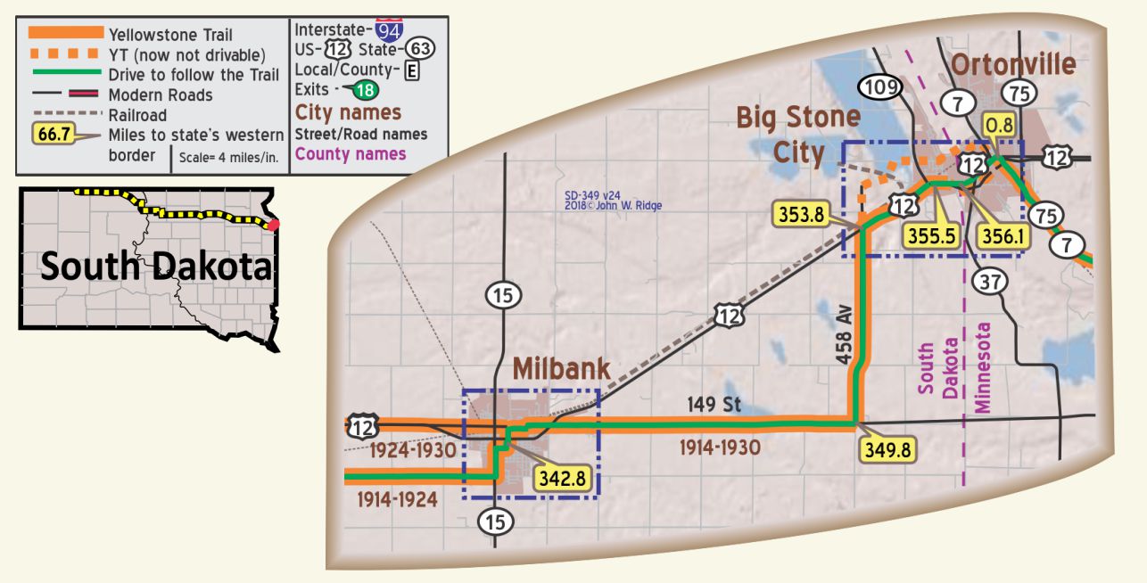 SD-342.8 Milbank
(1,148 alt, 2,549 pop.), was named for Jeremiah Milbank, a director of the Milwaukee R.R., which was extended through the city in 1880. A windmill, once used to grind grain from the surrounding country, has been moved to the center of the city, Left of US 12 (YT). WPA-SD*
pop; 2,600; county seat of Grant County; an exceptionally attractive and substantial-looking little city, in the heart of a noted dairy section. St. Hubert Cafe leads. City camp in the court house yard 50c.
HOTEL ST. HUBERT has good beds and running water in all rooms; sgl. $1.25-$1.50; dbl. $2; with bath $3.
ROGGENBUCK GARAGE, is reputed best for repairs; light mech. work until 11 p. m. Labor $1. Phone 87. MH-1928*.
As was true in many towns, Milbank had a Yellowstone Trail Garage in 1924.
The city’s “mascot” is a large windmill. According to their website, this 1882 windmill once powered a grain mill that supplied the town of Milbank with sustenance until 1907. It has been moved around the city, but it is now on display along US 12 (Yellowstone Trail). It has been completely renovated and a current announcement states that the mill will offer tours, and will be a working mill, one of only 50 in the country.
The corner of Third St. and Third Ave. The Grant County Museum is in a former Carnegie Library building. It houses Grant County memorabilia and artifacts.
NOTE: There is a misleading sign at Hardees restaurant on US 12 calling US 12 the Yellowstone Trail “coast to coast.” US 12 does not and never did go “coast to coast;” it ends at Detroit. Today, highways that now fall on top of or are near the old transcontinental Yellowstone Trail are numbered variously, 14 U.S. numbers, 25 state numbers, two Interstate numbers and a myriad of county numbers or letters, certainly not a single number such as US 12.
SD-353.8 Big Stone City
(979 alt., 675 pop.), overlooks the lake from which it takes its name, and, in addition to being a summer resort center, has a brick factory, corn cannery, and granite quarry; During summer and fall the population becomes considerably larger. WPA-SD*
Big Stone City is at the eastern end of the South Dakota leg of the Yellowstone Trail. It lies at the southern tip of Big Stone Lake. Originally the county seat for Grant County, the county seat was moved to Milbank in 1880 after a much heated battle between the two towns.
Around the time the Yellowstone Trail went through, the town was considered a summer resort center for the surrounding area. Trail travelers no doubt visited Big Stone Lake, a narrow freshwater lake and reservoir and source of the Minnesota River which today, 100 years later, is still a good fishing and great recreational site. There is also a nature reserve here.