

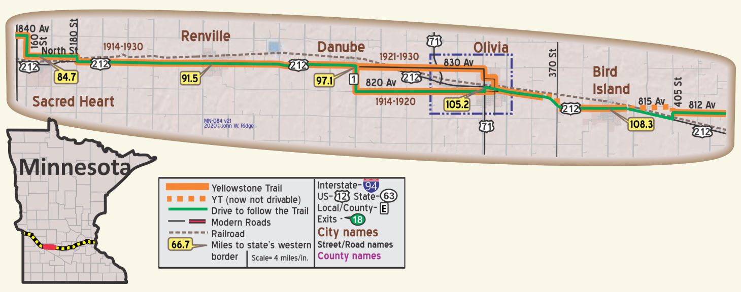
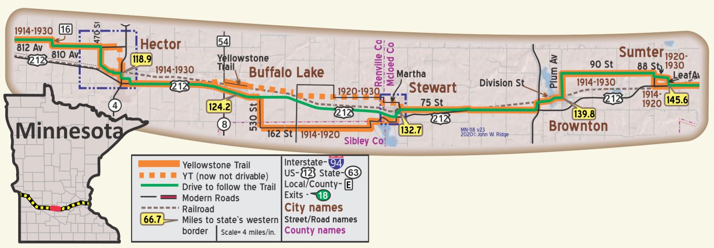
 The map’s green circle markers
are modern highway exit numbers used for current location reference.
 The map’s yellow rectangle mile markers show path of YT and distance from state’s west border.
While following the Travel Guide’s details below, click the corresponding text for Google Maps link.
 For Directions, click the Minnesota (MI-) State YTA Mile Marker Numbers (below) linking you to a real-time map.
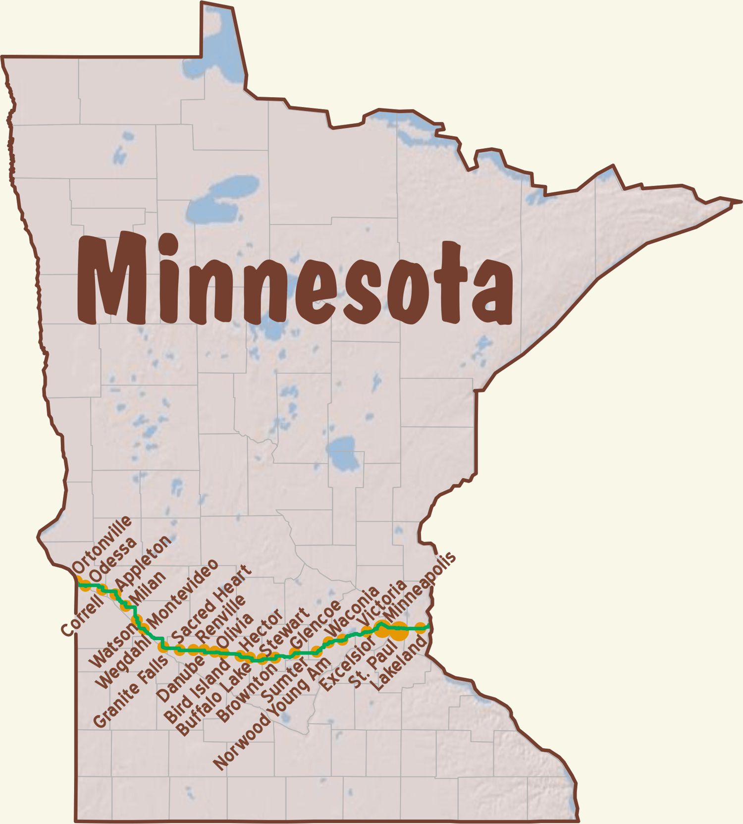
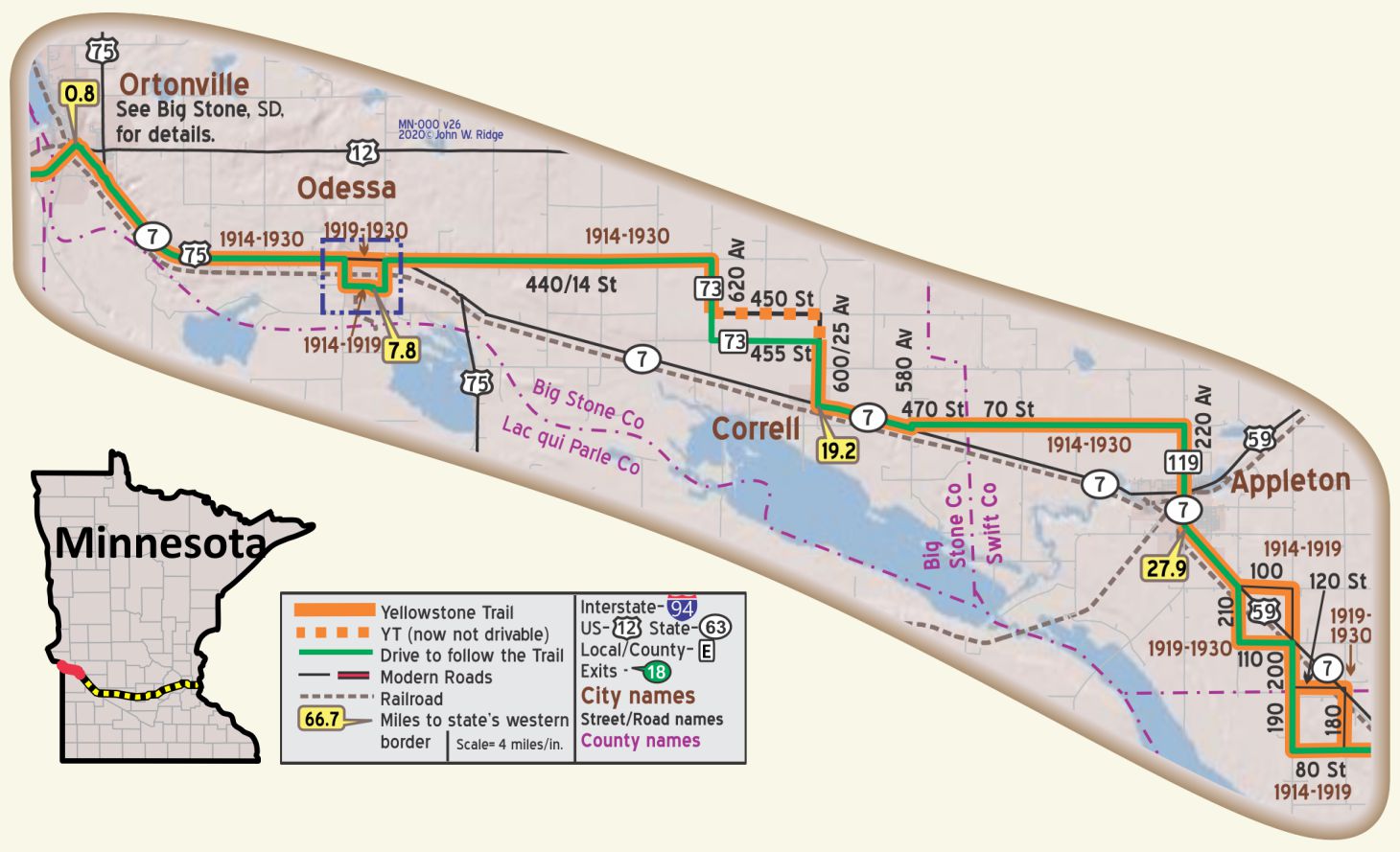
MN-000.0 S. Dakota/Minnesota Line
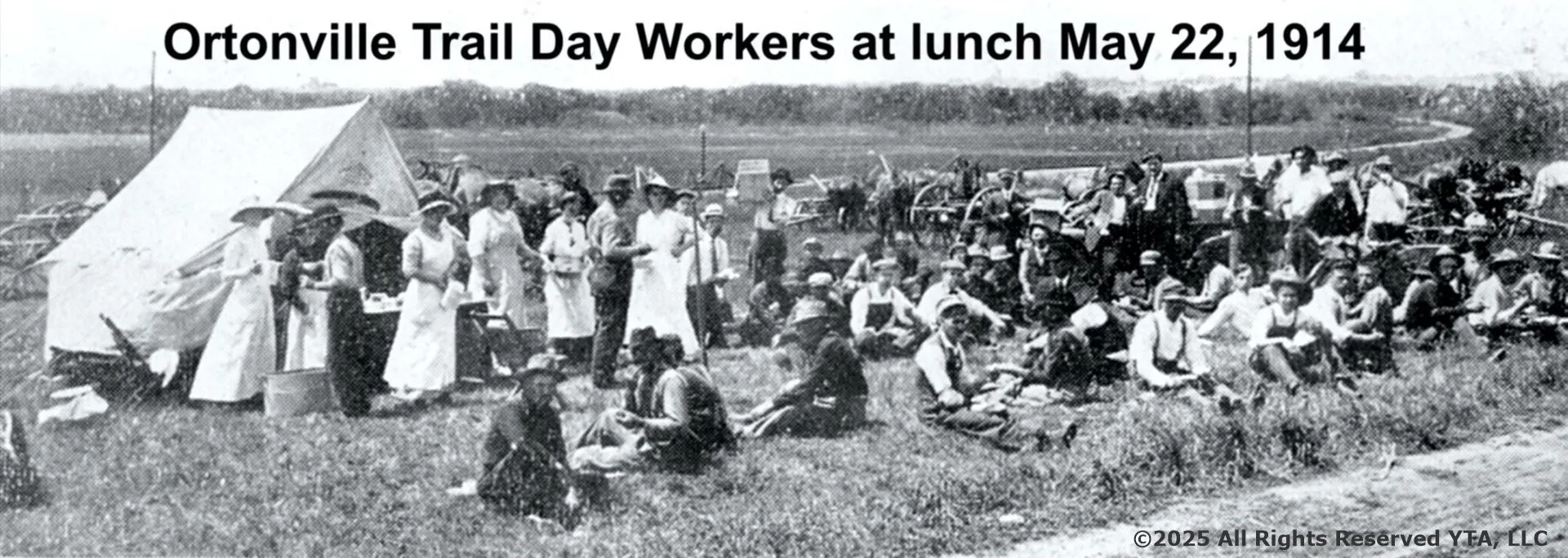
MN-000.8 Ortonville
pop. 2,500, alt. 990 ft.), situated at the foot of Big Stone lake, a body of water nearly a mile wide and about thirty miles long, is a summer resort of considerable importance. The scenery of the Minnesota valley and along Big Stone lake is most picturesque and attractive. BB1921-10*
COLUMBIAN HOTEL modern and well kept; all outside rooms. A. P. $3.25; with bath $3.75; breakfast 50c; lunch or dinner 75c.
H. J. McDOWELL GARAGE services all cars and reputed best. Open late. Ph. 24-J. MH-1928*
Today the town is known for its granite-quarrying and canning industries. Seven large quarries operate throughout the year and provide an income to hundreds of families. WPA-MN*
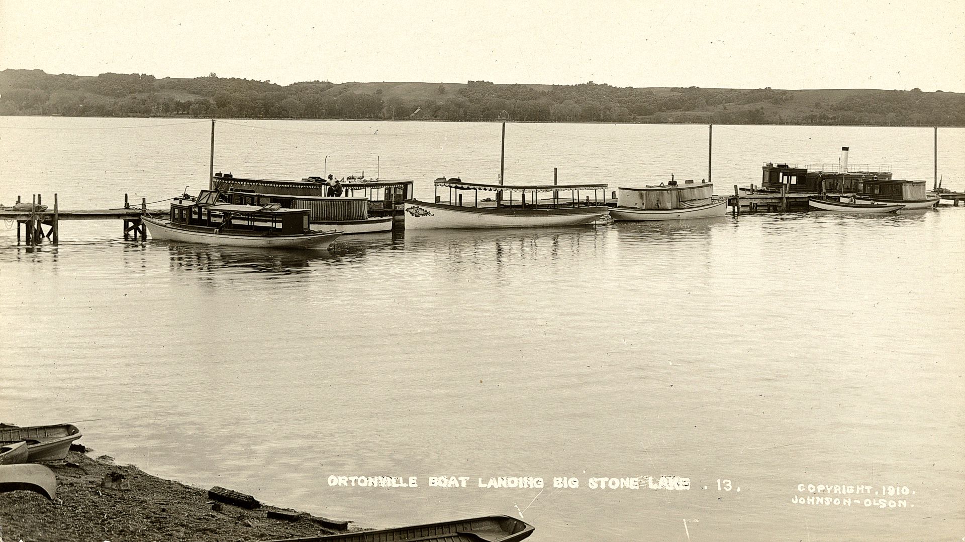 1910 Oronville Boat Landing at Big Stone Lake
The Big Stone Lake Area comprises Ortonville, the Big Stone Lake and Park, and crosses the state line to Big Stone City, South Dakota. The area jointly features many outdoor activities connected with the lake. There is also hunting and a corn festival. The lake is the headwaters of the Minnesota River. From here to Granite Falls you are in the Minnesota River Valley.
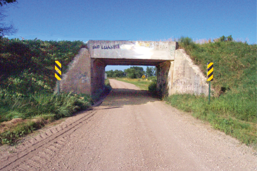
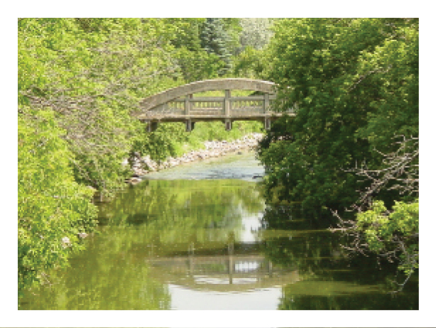
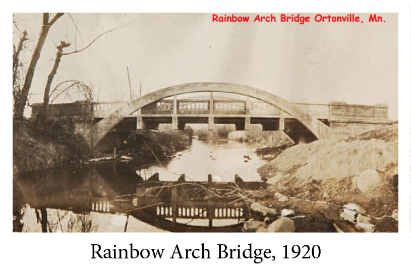
Between Ortonville and Big Stone Lake is an abandoned Marsh Rainbow Arch Bridge which crosses the Minnesota River. It once carried the Yellowstone Trail.
Click Here for Ortonville’s Marsh Rainbow Arch Bridge History.
See photos below. The bridge is a fine example of a now rare concrete bridge type. It can be seen from the US 12 bridge, and you can get closer by taking County 37 which turns off of US 12 and walking a bit. It is a footbridge now. Similar bridges near the Yellowstone Trail can be found in Anaconda, Montana, and Chippewa Falls, Wisconsin.
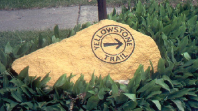
Big Stone County Historical Museum Jct. Hwys 12 and 75. You can’t miss this. There is a huge coat hanger-like sculpture set in concrete in the yard. It is called Paul Bunyan’s boat anchor. The museum features wildlife collections. Note the Yellowstone Trail sign displayed in the front yard. See also the 1909 “Muskegon Boat” that once plied the waters of Big Stone Lake.
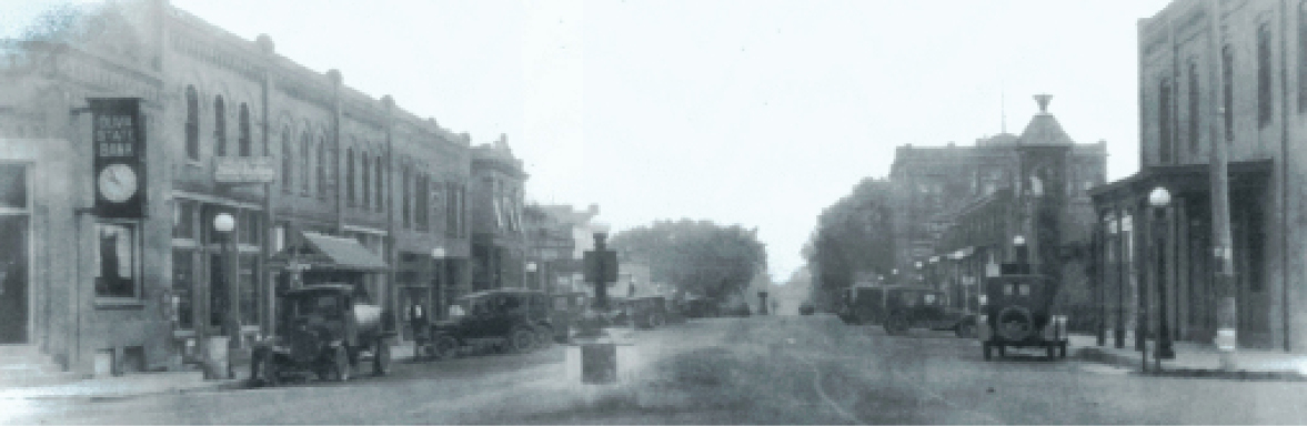
Ortonville Commercial Historic District 2nd St., Madison and Monroe Aves., between Jefferson and Jackson Aves. GPS: 45.30611, -96.44639. Long-serving commercial district is noted for its uniform Victorian buildings. It is representative of the region’s small towns but unique for their purple granite trim, and the district contains 19 properties built between1879 and 1922.
A downtown landmark, the 1892 Columbian Hotel, burned down in 2012, another historic loss for the traveler on the Yellowstone Trail.
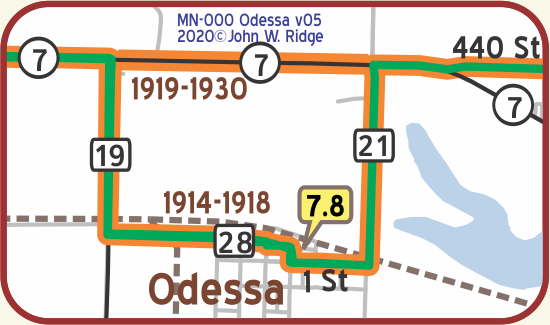 MN-007.8 Odessa
Odessa and towns south (Correll, Appleton, Milan) are prime sites for bird watching: white pelican nesting colonies, flyway zones, and shorebirds which have been migrating through the area for eons. Yellowstone Trail travelers of 100 years ago may have watched just as present travelers are now doing.
Big Stone National Wildlife Refuge, just south and east of Odessa, is home to 230 bird species.
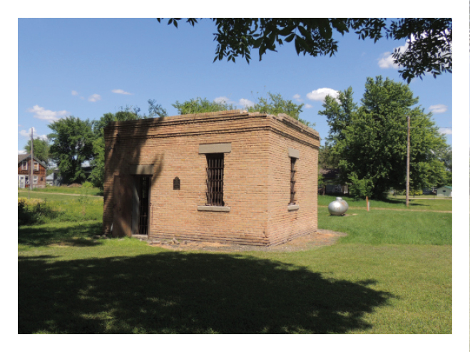
Main Ave. and 2nd St. GPS: 45.25973, -96.32894. Odessa Jail is Odessa’s oldest public building, built in 1913.
It is a rare surviving example of the freestanding brick jail houses once common in small Minnesota towns (also seen in Montana).
MN-019.2 Correll
pop. 180; garage, gas and supplies. Small pay camp, 25c. MH-1928*
MN-027.9 Appleton
pop. 1,700; a grain growing and dairying center. Brown’s Hotel has running water; dbl. $1.75. APPLETON AUTO CO., Ford, finely equipped and best for all makes. Labor $1; phone 235 for tow car until 10 p. m. MH-1928*
Bordering the river in the northeastern section of Appleton is a beautiful park, formerly a slum district. It was recently laid out and constructed as part of a Federal relief program. WPA-MN*
~ In Appleton, All of its 32 streets, except Minnesota St. are named for Local Veterans who died in combat ~

The YTA gives a “SALUTE” to Appleton for it’s great sacrifices, and, honors them for their continuous patriotism.
While touring the YT, please stop in Appleton.
The Appleton Veterans of Foreign Wars (VFW) Post 4955 Facebook Page gives more information.
↔
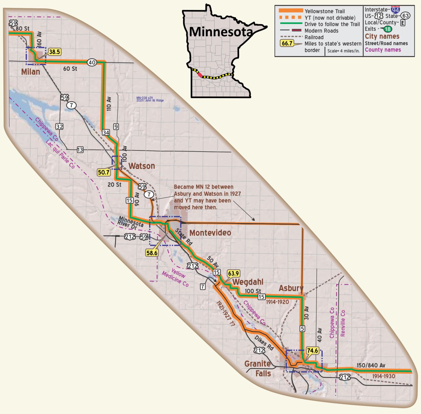
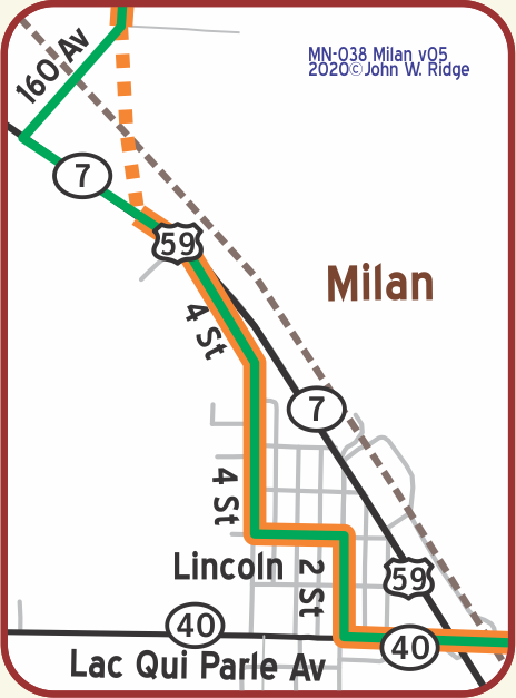 MN-038.5 Milan
pop. 600; a center of diversified farming. Halling’s Garage is good. Nelson’s Hotel has running water and serves good meals. Free camp space. MH-1928*
Whether the town of MILAN (1,010 alt., 548 pop.) 95 per cent of whose citizens are Norwegian, was named for the Italian city, is not known. An unusual gala event, the Lefse Fete, is held in Milan in August. WPA-MN*
Today Milan is still a leading center of Scandinavian culture and ethnic arts.
Route of YT on 2nd in Milan is uncertain.
 RR underpass north of Milan replaced YT level crossing south of Milan
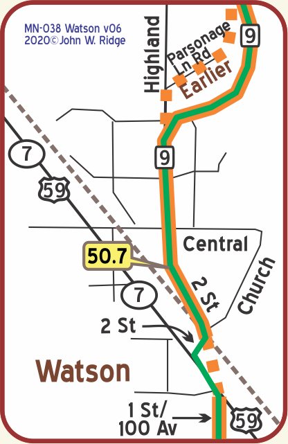
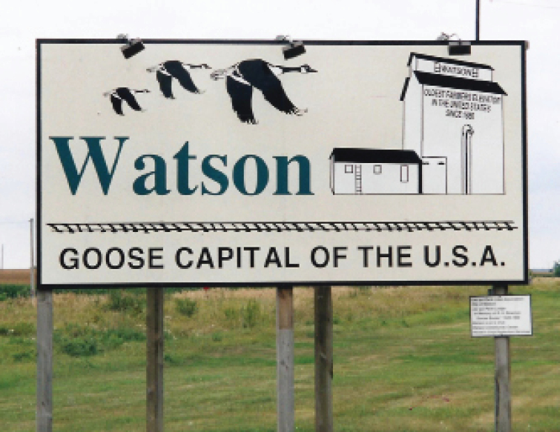 MN-050.7 Watson
Goose Capital of the World.
Click here for information.
WAYSIDE – Running just south and west of the Yellowstone Trail along the Minnesota River between Ortonville and Watson are various state and federal wildlife management areas known for bird watching. Just north of the Lac qui Parle Mission and about two miles west of the Trail is Lac Qui Parle State Park, known as a stopover for thousands of migratory Canada geese, bald eagles, pelicans, and other waterfowl. GPS: 45.02370, -95.86860.
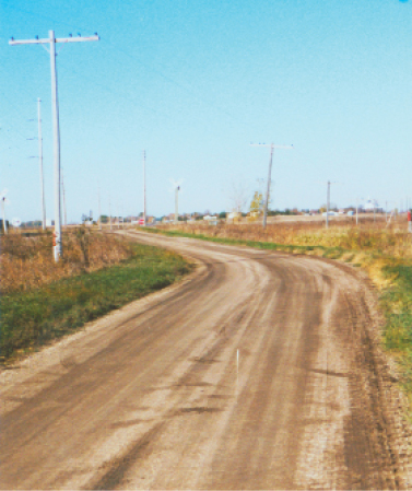
NOTE – This section gives a feeling for the indirectness of the original YT and some sections are gravel. The pavement around MN-021.3 is marked “minimum maintenance” but was quite driveable in recent years.
WAYSIDE – Just west of Watson and south of Milan near the junction of Co 13 and Co 32 at the Minnesota River is Lac qui Parle Mission. The site was established in 1835, where the first Dakota dictionary, grammar, and gospel were completed. A chapel built by the WPA features artifacts and exhibits related to the Dakota and missionaries who worked with them.
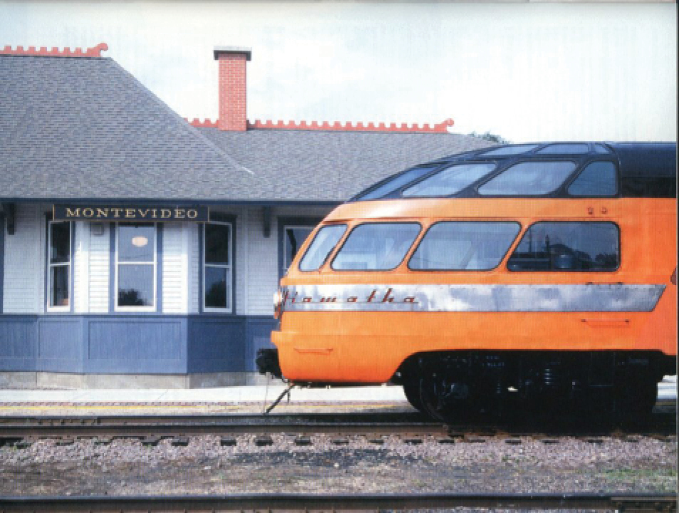
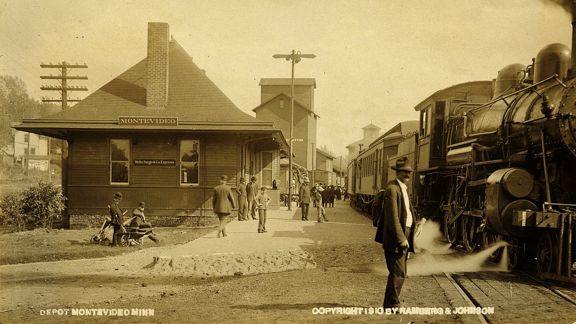
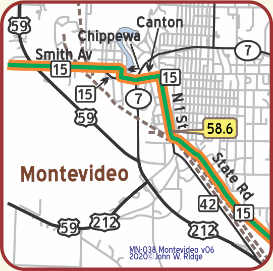 MN-058.6 Montevideo
Between Montevideo and Granite Falls the route is in the valley of the Minnesota River.
pop 4,900; a county seat and has beautiful 30-acre park on Chippewa River; a great shipping point for hogs and milk-fed chickens. Eandguard’s Cafe is best. Pine camp site in park.
HOTEL RIVERSIDE modern and very well kept; sgl. $1.25-$1.50; dbl. $2; with bath $2.50-$3.
CLAY MOTOR CO., leads by far; 24 hr. serv.; Labor $1; phone 165. MH-1928*
(922 alt., 4,319 pop.), seat of Chippewa County, was named for the capital of Uruguay; Smith Park, on the western edge of town, is a 35-acre Tourist Camp (free kitchen facilities). The bluffs of the city offer a remarkable panorama of the merging valleys of the Minnesota and Chippewa Rivers. WPA-MN*
151 Pioneer Dr., Jct. of Hwys 212 & 7 Chippewa City
Pioneer Village. Here is a “must see.” About a mile north of Montevideo you will come upon Historic Chippewa City. It was platted in 1868. Then Montevideo was platted in 1870 and Chippewa City ceased to exist. Today one can see it rebuilt in 24 buildings preserved or period buildings moved in from various locations in the county. It is operated by the Chippewa County Historic Association. It’s fun to stroll there through yesteryear.
Along the Minnesota River is the Lagoon Park, there since 1919 and now a modern camp ground with all of the current facilities.
301 State Rd (Yellowstone Trail). Milwaukee Road Heritage Center Museum at the restored 1903 Milwaukee Railroad Depot. The place has equipment, memorabilia, and facilities to show what transportation was like in Montevideo for almost a century.
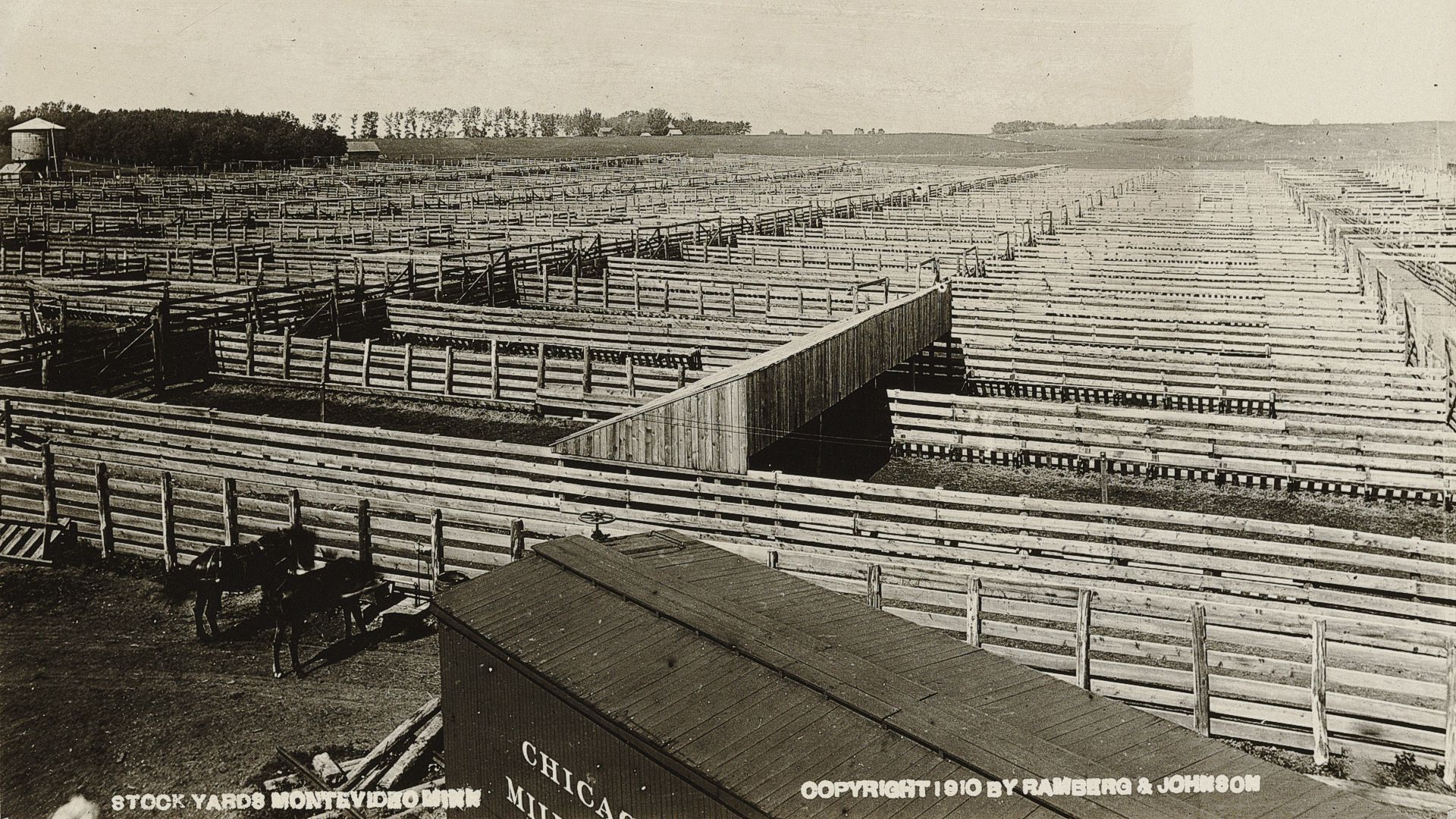
1910 Stock Yards Montevideo
MN-067.5 Olof Swensson Farm Museum
John Swensson turned his father’s original farmstead into a museum. The farmstead consists of 17 acres, an 1880s timber-framed barn, grist mill remains, family cemetery, and a 22 room brick farmhouse. Constructed in 1901, the house contains original furnishings from this unique Norwegian/Swedish family. We were surprised to see a sizeable family chapel within the farmhouse. It is listed in the National Register of Historic Places.
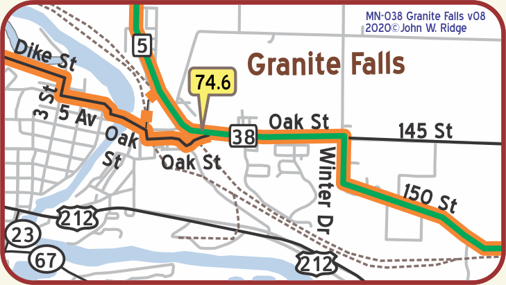
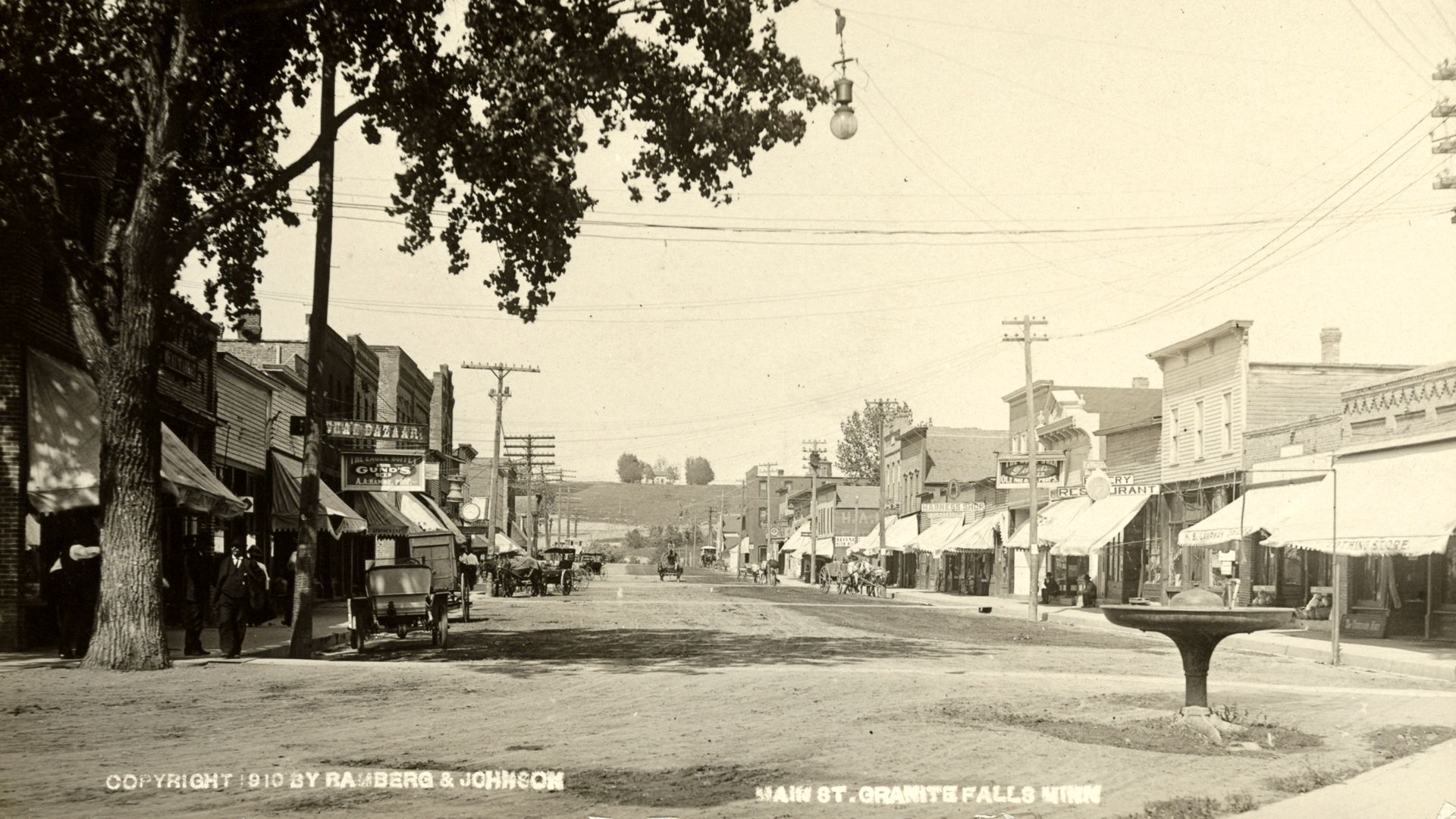
MN-074.6 Granite Falls
pop. 1,800; in midst of fine stock and grain farms. Keegan Hotel has rooms with running water.
Winter Garage is largest. Free camp on river, is fair. MH-1928*
(922 alt., 1,791 pop.), is on a boulder-strewn bluff overlooking the Minnesota Valley. In the valley Archean granite is exposed; these rocks belong to the oldest era of geological history. The founders of the town were attracted by the power possibilities of the falls. WPA-MN*
At Granite Falls Dam, if you are there in early summer, notice the beautiful American White Pelicans in residence when the water is high. With large, black tipped white wings, these great birds dive gracefully and live seemingly cooperatively.
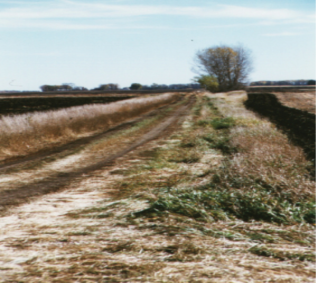
On the northern edge of town, running NW to SE is Dikes Road, a gravel road on top of dikes. The Yellowstone Trail of 1921-30 ran on this road.
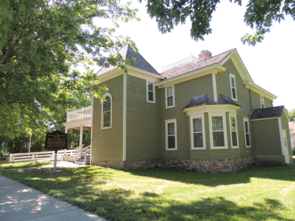 163 Ninth Ave. Volstead Museum. (see photo)
This was the home of Congressman Andrew Volstead, most known as the author of the Volstead Act which enforced the 18th amendment to the U.S. Constitution which banned the production of alcohol (known as Prohibition). It was ratified in 1919 and repealed in 1933 with the 21st amendment. He also authored the important “Cooperative Act” which allowed farmers to band together to bargain with companies for a fair price. Agricultural “cooperatives” still stand today.
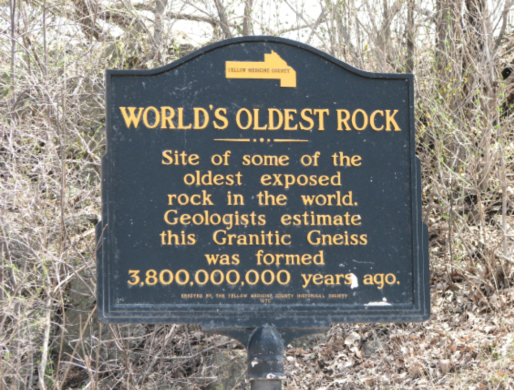
At MN 23 and MN 67 near the Minnesota River is the Yellow Medicine County Historical Museum. This museum’s displays tell a story of the geology and archaeology of the Minnesota Valley, Native American history, and pioneer life in the county. Ask them about the oldest granite in the world, granite gneiss about 3 billion years old, that is visible in the area.
 WAYSIDE –
Nine miles south of Granite Falls in Hanley Falls is Minnesota’s Machinery Museum.
A five-building complex displays a large collection of
tractors, vintage cars, old farm implements, and,
a farm house used in Yellowstone Trail days.
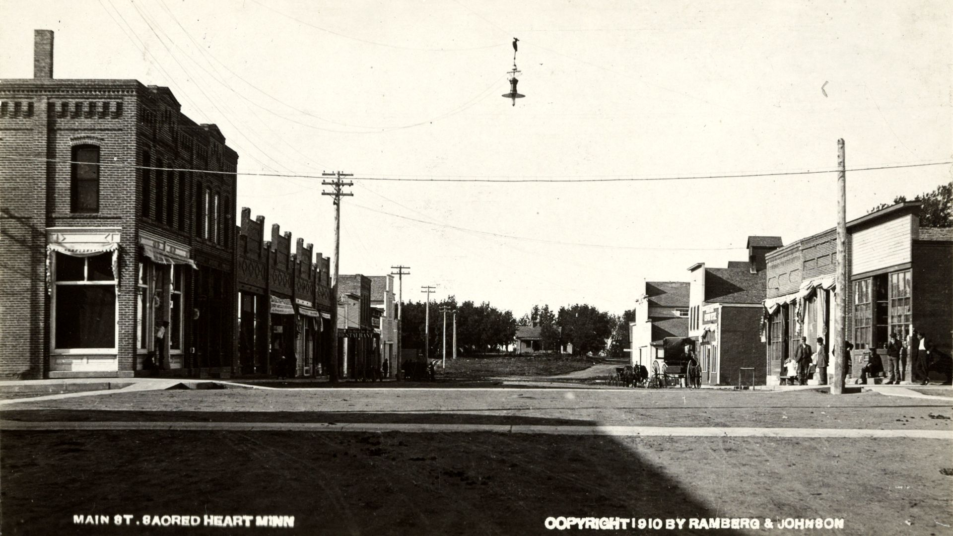
 MN-084.7 Sacred Heart
pop. 800; named by the Indians, not a Catholic town; has some of largest quarries of best granite in the state. Free camp space in City Park
SACRED HEART HOTEL most pleasant and claimed best between Aberdeen and Minneapolis; sgl. $1.25-$1.75; dbl. $2; with bath $2.50. Breakf. 50c; dinner 75c; no lunch.
STAVNE’S GARAGE, is best for repairs; labor 75c; open until 11 p. m. MH-1928*
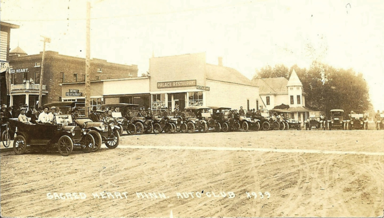 Sacred Heart Auto Club
The 1914-built Sacred Heart Hotel on the main drag is still there!
The Sacred Heart Historical Society won National Register of Historic Places status in May, 2018 and is in line to receive grants from the Minnesota Historical Society to preserve the building for reuse.
300 5th Ave. W (US 212) Sacred Heart Area Museum. It is in a Lutheran church built in 1916 and displays and preserves the history of the Sacred Heart area.
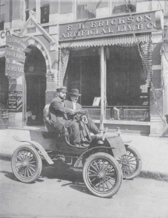
MN-091.5 Renville
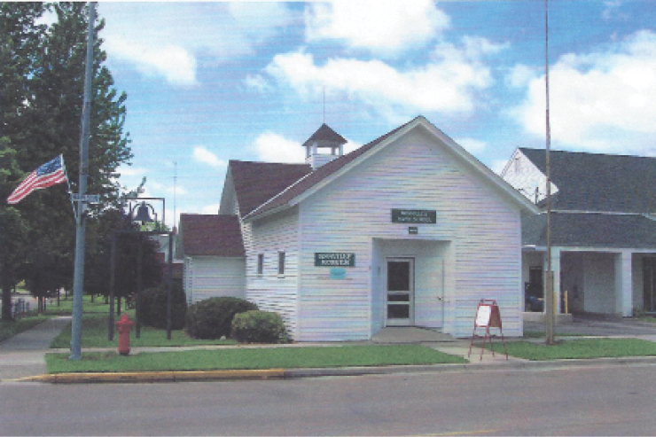
202 N Main St. Renville City Historical Museum in a late 1800s schoolhouse. The museum features many materials regarding former resident Michael Dowling, an amazing man who, despite triple amputations, was a “Good Roads” leader, teacher, and newspaper publisher. He later moved to Olivia where he was a banker, garage owner, president of the Yellowstone Trail Association 1917-1918, and friend of President William McKinley. For Dowling’s inspiring biography, see Trail Tale: Dowling.
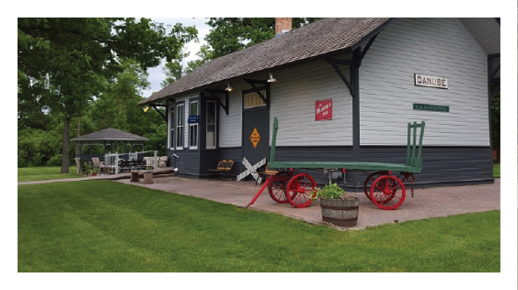
MN-097.1 Danube
pop. 300; country hotel; Service Garage leads. MH-1928*
After 30 years of life near Olivia, Minnesota, the depot was rolled back into Danube and settled in the shadow of the Water Tower, near its original site. It houses railroad and local history. The traveler today should look up to see the water tower and follow it to find the historic depot.
There recently was formed “The Yellowstone Car Club” to honor the historic highway that ran through Danube.
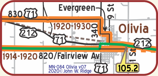 MN-105.2 Olivia
pop. 1,800 in the midst of many fine farms and dairies. YELLOWSTONE CAFÉ is liked, inquire here for good rooms. Small free camp space.
IKE’S REPAIR SHOP, Ford; is far best; well equipped; phone 200 until 9 p. m.; after 9 ph. 170 for wrecker. MH-1928*
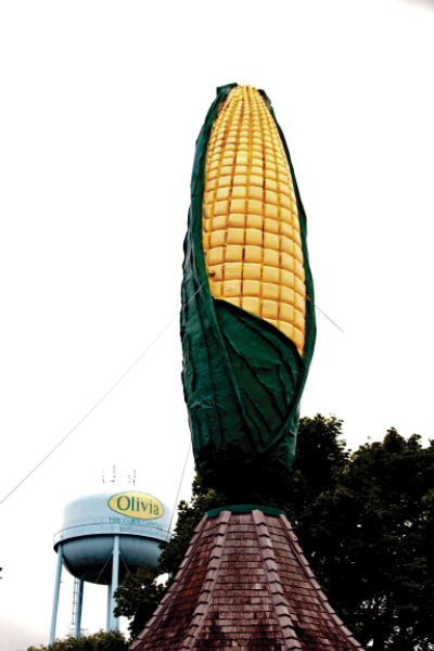
Designated as the “Corn Capitol of the World” (see photo) by the Minnesota Senate, that motto is borne out by the startling 50-foot tall ear of corn statue.
The area has the highest concentration of seed research companies of any place on the globe. “Corn Days” are celebrated the last weekend in July which we have attended, representing the Yellowstone Trail Association. Fun!
801 E Lincoln Ave. (MN 212, Yellowstone Trail) corner of E Lincoln and 9th St. S. Here stood the Olivia State Bank, Michael Dowling, President, and next door was Dowling’s Garage at 803-807 E Lincoln Ave. You already met Dowling if you read about Renville, 14 miles west of Olivia.
500 East DePue St. The historic Renville County Courthouse, built in 1902, is architecturally significant as a fine Victorian monumental building with a mixture of French, classic, and Georgian styles. The newly renovated building with its copper domes is worth seeing.
Click here for Trail Tales: Michael Dowling
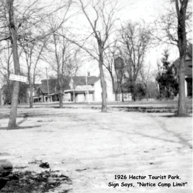
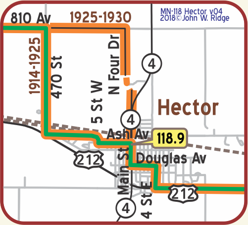 MN-118.9 Hector
pop. 900; a farming community; rooms in homes. Hector Motor Co. leads, has wrecker.
Good free camp in park. MH-1928*
(1,018 alt., 864 pop.), is in a region formerly known for excellent water-fowl shooting. While extensive drainage eliminated much of the game, Mongolian pheasants, recently introduced into the locality, are now quite numerous. A free Tourist Park. WPA-MN*
206 S Main St. is Rural American Bank, built in 1916. And the building is still recognizable as pure Prairie School.
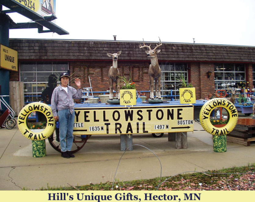
US 212 E (Yellowstone Trail). Hill’s Unique Gifts. You’ve got to stop here. It is a delightful tourist trap. We mention it because it once had large, yellow Yellowstone Trail signs out front, but now they are somewhat muted. There are thousands of unique items you don’t need but would find kooky. See for yourself. Hill’s is the Yellowstone Trail’s answer to the kitsch of Highway 66.
November 6, 1919 Hector Mirror:
HECTOR BUSINESSMEN OPPOSE CHANGE IN ROUTE OF TRAIL
The Club Room of the Village Hall was crowded with citizens to discuss a matter it having been reported that the State Highway Commission was to change the route of the Yellowstone Trail. The Club voted unanimously against such a proposed change, and voted to pay Hector’s allotment for the upkeep of the Yellowstone Trail.
NOTE: A state highway commission does not “move the Yellowstone Trail;” it declares a different highway a state highway and it is up to the Yellowstone Trail Association to move its signs to the new, better highway. This threat seems to have jarred the group into paying their dues.
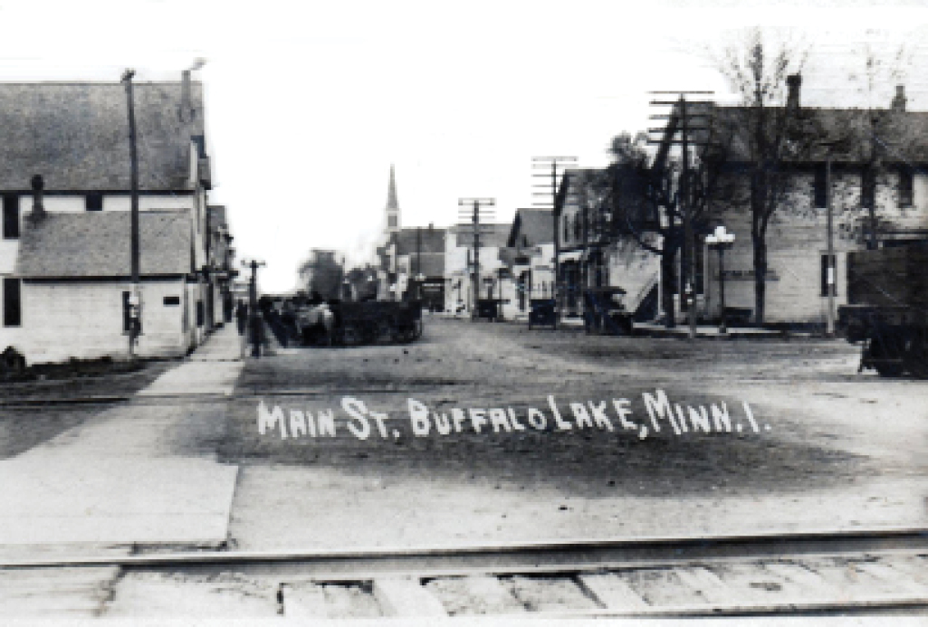
MN-124.2 Buffalo Lake
pop. 460; in a stock and grain-raising area. Rooms at Yellowstone Hotel; not modern. Frank’s Garage is best. Free camp, two blocks from Trail. MH-1928*
US 212 still is called Yellowstone Trail in Buffalo Lake. There is a senior housing complex at 703 W Yellowstone St. Many businesses are on it, but the old Yellowstone Trail Hotel, on that road and once the life blood of the village, is no more.
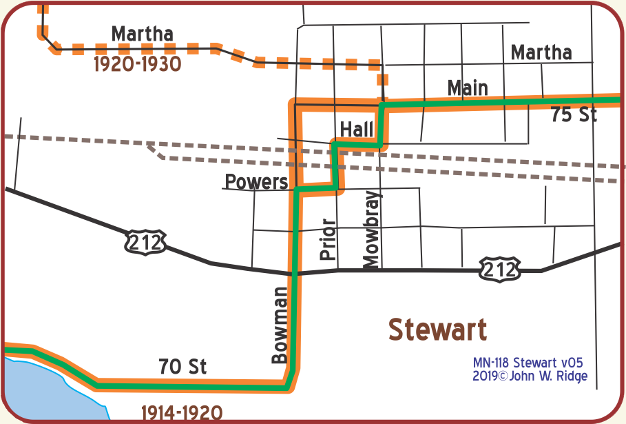 MN-132.7 Stewart
(1,063 alt. 541 Pop) on the eastern edge of a 50-mile undulating plain covered with rich glacial drift. West of the lakes scattered in the eastern part of this expanse, the horizon is broken by moraines. WPA-MN*
pop. 550; rest room at community hall; country hotel, small garage, free camp space. MH-1928*
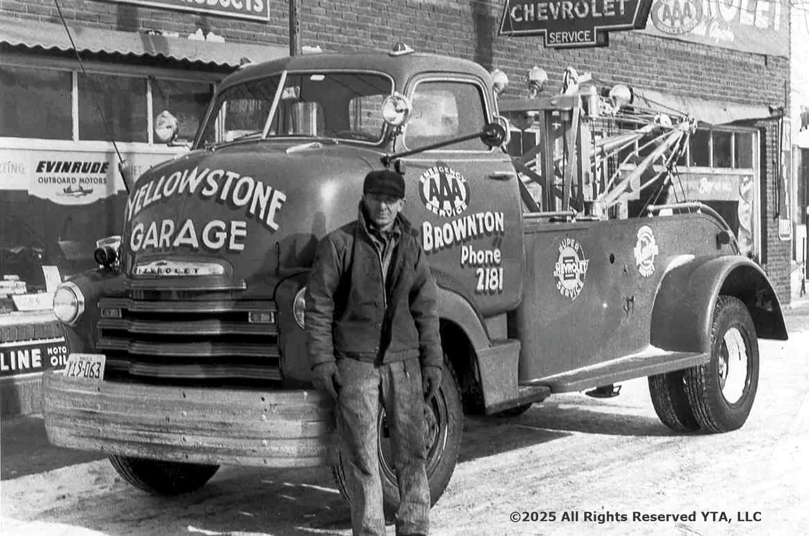
MN-139.8 Brownton
pop. 650; stock and grain raising supply principal revenue. Commercial Hotel is best, not modern. Yellowstone Trail Garage has best mechanics. Free camp space two blks. from trail. MH-1928*
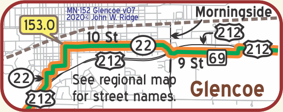 MN-152.0 Glencoe
pop. 1,750; an old and substantial town; a cattle-shipping point; best rooms in homes; Sweet Shop for lunch. Beneke Garage has good mechanic. Nice free camp in oak grove. MH-1928*
Glencoe was named for its resemblance to a valley in Scotland. City Hall, County Courthouse, and Carnegie Library all were built at the turn of the 20th century (thus probably seen by Yellowstone Trail travelers) and all are on the Register of Historic Places.
MN-163.2 Norwood Young America
Norwood pop. 550; a village; country hotel. Lunow’s Garage is reasonable and has skilled mech. Free camp space; no conveniences. The Grivelli house has rooms and serves excellent home-cooked meals, 60c. Good Buick garage. MH-1928*
Norwood Eastbound: Choose to either stay on the later YT, or, follow the earlier YT and go north from Norwood. Leave Highway No. 212 and follow the Yellowstone Trail Highway No. 5.
NOTE FROM MH-1928: No. 12 (today is 212) via Chaska has fewer turns and better surface but the Yellowstone Trail passes many beautiful lakes and is much prettier and a little shorter. MH-1928*
Norwood and Young America became one city on January 1, 1997.
Elm and Hazel Sts. (Elm is the Yellowstone Trail.) Winter Saloon. GPS: 44.76791, -93.929036. A c.1890 saloon with attached living quarters, Norwood’s oldest and best preserved drinking establishment and a prominent feature of its downtown. In the 1890s the second floor was used by fraternal organizations. It is also known as Harm’s bar since it was in the Harm family for three generations. The price of a liquor license in 1891 was $2.08, $1,500 in 1954. On the National Register of Historic Places.
224 Hill St. Norwood Methodist Episcopal Church. GPS: 44.76793, -93.92818. Built 1876, this small, architecturally interesting church looks freshly painted white with red trim. It appears to be in active use, cared for, and welcoming.
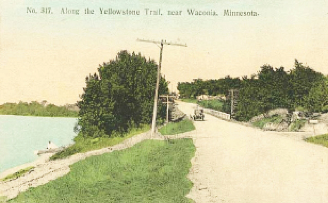
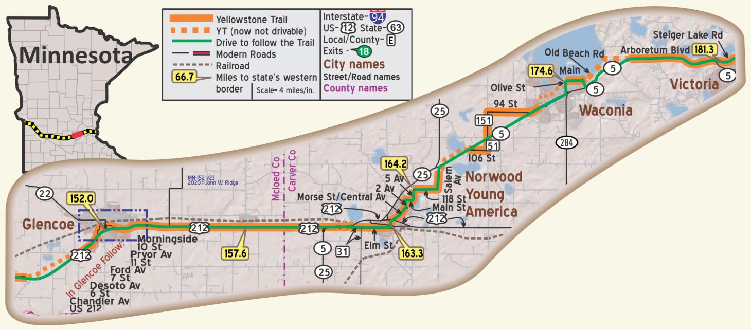
MN-174.6 Waconia
pop. 1,000; a pretty little town on Lake Clearwater. This famed lake, together with Paradise Isle, is one of the outstanding beauty spots of Minn. Boating and fishing at its best. Hotel North Star has clean rooms, not modern. Menzel Garage is good and has wrecker. MH-1928*
The 1928 Mohawk-Hobbs Guide (above) is interesting because it calls the lake “Lake Clearwater” when it seems that it was always called Lake Waconia, and, although the name of the island in the lake was called “Paradise Island” in 1927 and 1928, that name lasted only for a brief time and reverted back to “Coney Island.”
Yellowstone Trail travelers, no doubt, stopped to see Lake Waconia 100 years ago just as you can see the lake, beach and park today. Coney Island Resort, formerly a drawing card to its famous Coney Island, is now gone. At present, Carver County is working to eventually return the island to a recreational and historical site.
9 W. First St. Waconia City Hall, a red brick civic building designed in 1909 to accommodate city offices, fire station, library, senior center and public hall. It is noted for its locally unique architecture.
555 W 1st St. Carver County Historical Society Museum. This museum is on the move and they know about the Yellowstone Trail. Much preservation work occurs, along with activities in the museum itself. It’s a jumpin’ group. Ask for directions to the Andrew Peterson historic orchard farm which the Society owns.
48 W. Main St. (Yellowstone Trail). Mock Cigar Factory and House, nicely painted green and white. It was a false-front factory and attached Italianate house (c.1875) owned by E. H. Mock, proprietor of an early Waconia industry, and is on the Register of Historic Places because the property is associated with important American history events.
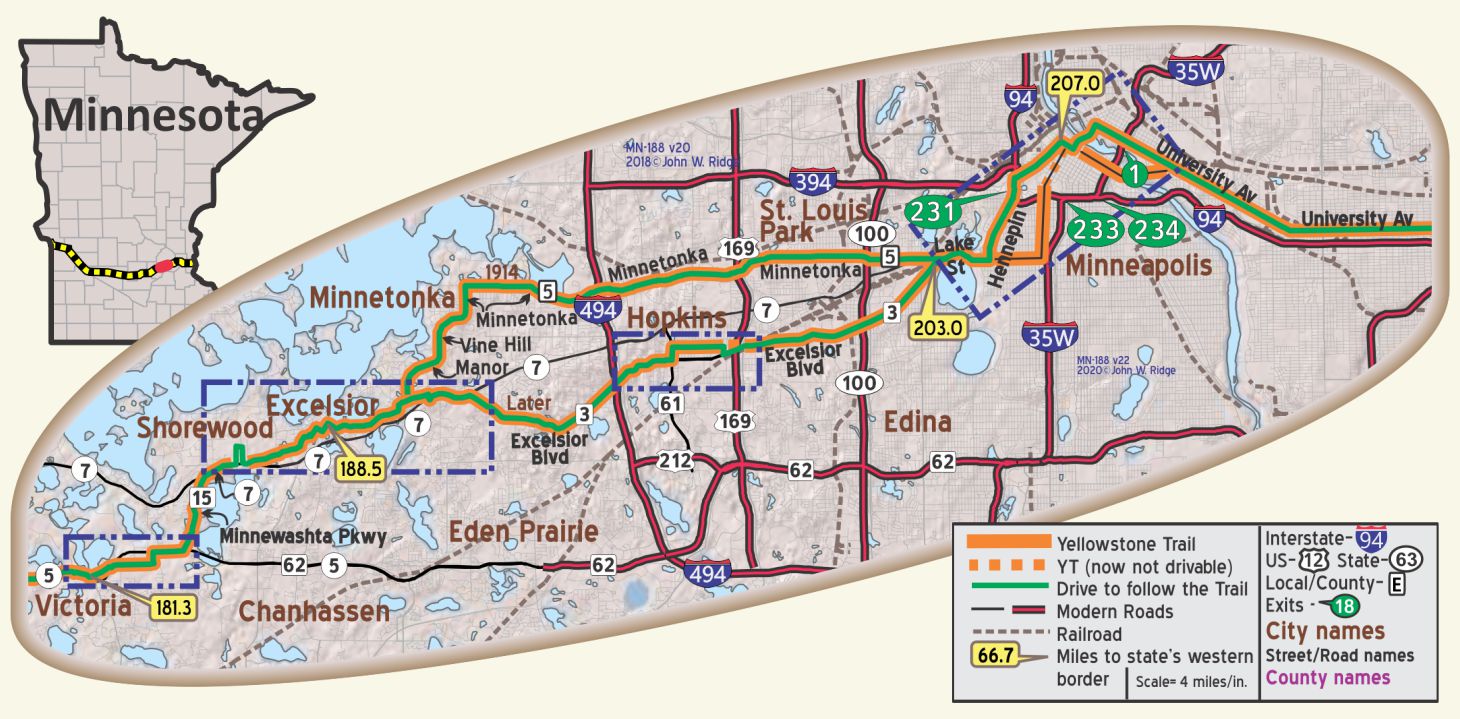
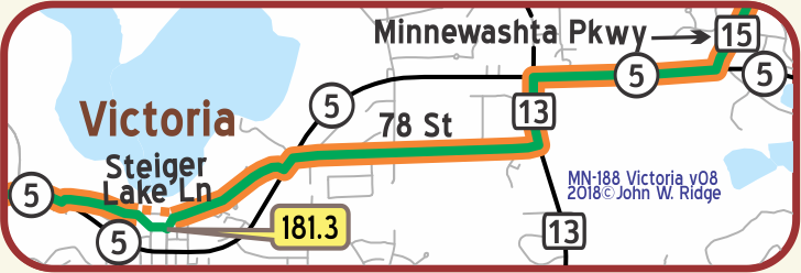 MN-181.3 Victoria
The City of Victoria is known as the “City of Lakes and Parks.” It is surrounded by lakes and borders the University of Minnesota Landscape Arboretum and Three Rivers Park District’s Carver Park Reserve.
Just east of Victoria, watch for the jog between Steiger Lake Rd. and 78 St. along MN 5. Traveling from the west the turn to the north to Steiger Lake Rd. is hard to see. It is just east of the Dairy Queen! For several blocks in the middle of Victoria the original YT cannot be followed, but now Steiger Lake Rd. can be followed. However, west bound travelers will need to work around a few blocks of one-way streets.
 MN-187 Shorewood
Today there is still a street named “Yellowstone Trail” running on the original alignment through Shorewood.
Yellowstone Press is located on this winding, hilly street amid an area of lovely homes. The western end of this section requires a detour because of the modern intersection with MN 7.
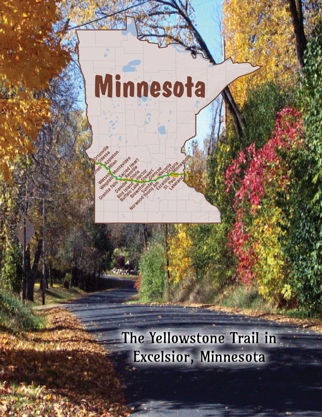
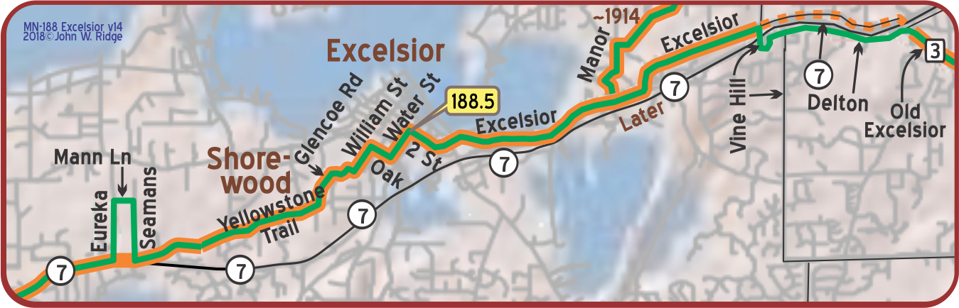
MN-188.5 Excelsior
305 Water St. Excelsior/Lake Minnetonka Historical Society Museum. Turn off of MN 7 at County MN 19 then right at Water St. “The hub of all activity in this quaint little town,” said a reviewer.
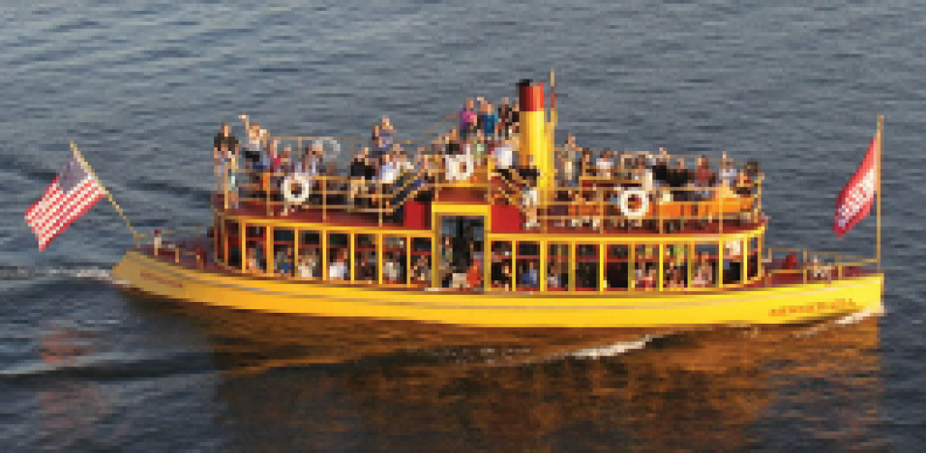
The Society runs the 1906 (restored) Steamboat Minnehaha on Lake Minnetonka tours.
The Society’s mission is “to preserve, document, and classify the physical history of the Lake Minnetonka area.”
37 Water St. The Museum of Lake Minnetonka is an all-volunteer organization that maintains and operates the 1906 Lake Minnetonka “streetcar” steamboat, Minnehaha. Take a ride. You will hear about the place in history the Minnehaha held in the early 1900s as you travel from Excelsior to Wayzata. The steamboats were not converted streetcars; they were constructed and painted to look like one as they transported vacationers to their lake cottages. After 1921 automobiles and better roads did the job. Four steamships were eventually scuttled, including the Minnehaha, and three were scrapped. Raised in 1980, the Minnehaha sat for 10 years before being totally restored and returned to service in 1996.
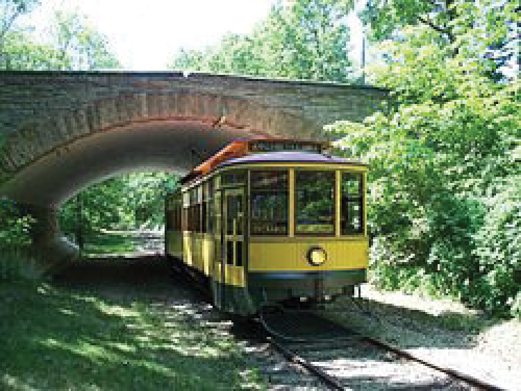
The Excelsior Streetcar Line near US 7. The Line’s station is between 3rd and George Sts. The electric trolleys reached Excelsior in 1905 after regular railroads such as the Milwaukee Road and the Great Northern ceased running tourists to resorts west of Minneapolis. Those trolleys were running when Yellowstone Trail travelers toured the area. Board at the Water St. stop between 3rd and George St. or at Old Excelsior Blvd. near Minnetonka Blvd. Reservations are not required. Cars are restored historical artifacts more than 100 years old. “We do not operate them in the rain. Occasional mechanical problems may force us to alter or cancel our schedule,” they say.
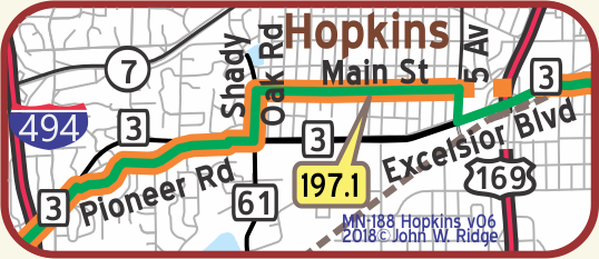 MN-197.1 Hopkins
pop. 4,000; a factory suburb of Minneapolis. Sustained largely by the Minneapolis Threshing Machine Co. which employs nearly 1,000 men. Hopkins Motor Co., Ford, is good on all cars. Free camp at Fair Grounds. MH1928*
703 Excelsior Ave. (the 1921 Yellowstone Trail) Yellowstone Trail Garage. Now site of Hopkins Honda Collision Center.
33 – 14th Ave N (earlier Yellowstone Trail) Hopkins Historical Society. A resource center of over 10,000 photos and other collections depicting the history of Hopkins and area. Click here for Hopkins Historical Society.
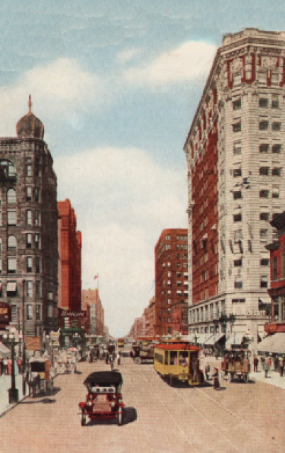
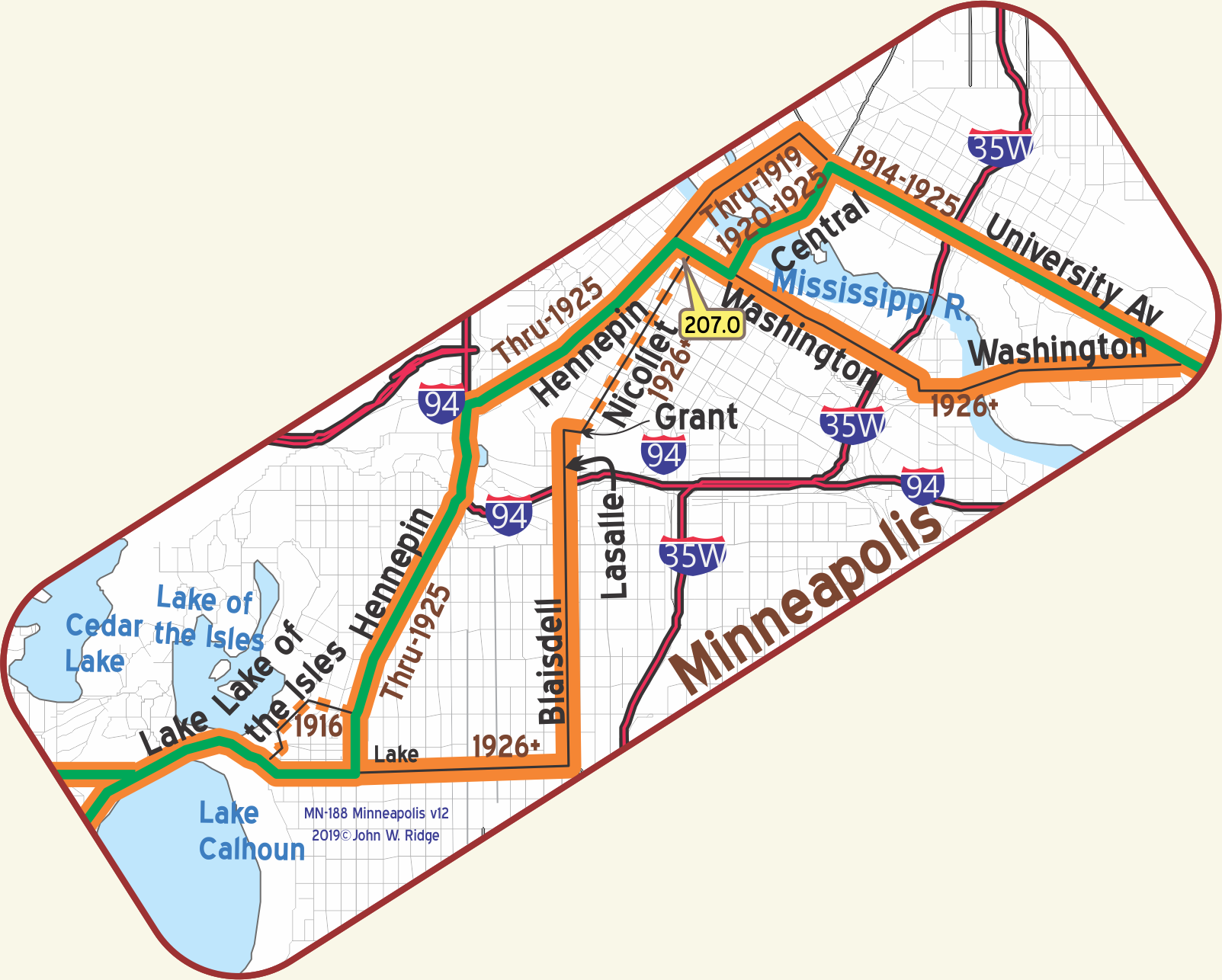 MN-207.0 Minneapolis
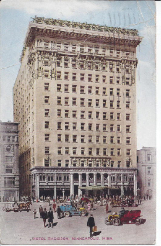
Minneapolis, situated on both sides of the Mississippi River, is one of the most beautiful cities in America. Its wonderful lakes, splendid boulevards and many parks are most enjoyable. A trip through the huge flour mills is very interesting. The high-class Auto Club is at 13th and LaSalle Ave. Municipal Tourist Camp, 50c, at Minnehaha Park, on Miss. River (southeast part of city). MH-1928*
HOTEL RADISSON well managed and high class.
Large and luxurious rooms; outside ones best. Sgl. $2-$6.50; dbl. with toilet $4-$5; with bath $5-$10.
CURTIS HOTEL the largest and one of the best liked in the Northwest. All rooms with bath; all rooms light. Sgl. $2-$3; dbl. $3-$4; twin beds $4.50-$6. Lunch 60c; dinner $1.MH-1928*
Since the Trail flowed right through downtown Minneapolis, many 100-year-old “skyscrapers” are visible there. Those sites described below surely would have been visited by the Trail’s travelers.
500 Nicolet Ave. The Andrus Building. Main office of the Yellowstone Trail Association from 1918-1923. From 1924-1926 the office was at 816 2nd Ave. S and finally from 1927-1929 it was at the “Evanston Building.” From these offices flowed hundreds of thousands of maps, weather reports, newsletters, research statistics and letters to individuals. Unfortunately, only a few original pieces of information remain. The organization ceased operation in 1930. Most official records and all undistributed publications were lost when the office was closed.
821 Marquette Ave. Foshay Tower. Set well back from the street and closer to 9th St. is a 1929 “skyscraper,” its 32 floors with the name FOSHAY emblazoned on the top are still easily visible today. Built to resemble the shape of the Washington Monument, it was finished just in time for the 1929 Stock Market crash. Story has it that some businessmen jumped from the tower at the prospect of financial ruin. Today it serves as a 4.5 star hotel called W. Minneapolis -The Foshay Tower. Do see the museum on the 30th floor.
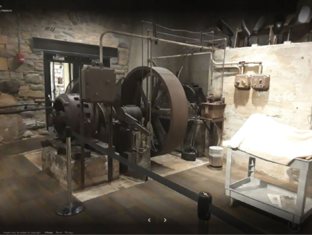
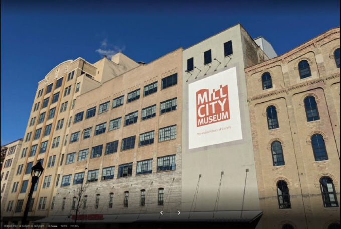
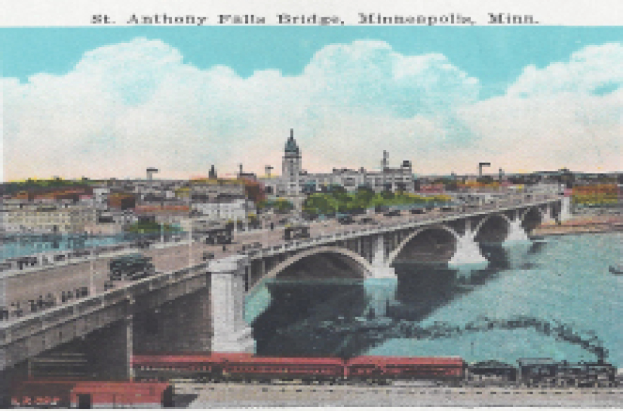
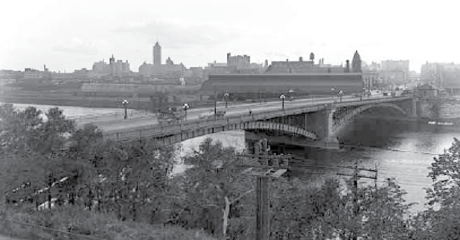
704 S 2nd St. Mill City Museum is a Minnesota Historical Society museum and a “must see.” It opened in 2003 built in the ruins of the Washburn “A” Mill next to Mill Ruins Park on the banks of the Mississippi River. Every working day, approximately 175 railroad cars of wheat were processed at the Washburn “A” Mill during its heyday. The area’s historic milling district used the power of falling water at St. Anthony Falls. Flour milling boomed and numerous mills along this stretch of river changed the way food was produced, marketed, and distributed.
The Mill City Museum focuses on the founding and growth of Minneapolis, especially flour milling and the other industries that used water power from St. Anthony Falls. The mill complex, dating from the 1870s, is part of the St. Anthony Falls Historic District. We include this site because of its powerful story-telling displays of the history of the Twin Cities.
You can see the Stone Arch Bridge and St. Anthony Falls from the roof. GPS: 44.97870, -93.25750.
1 Portland Ave. St. Anthony Falls Visitor Center and Lock and Dam.
St. Anthony Falls figured largely in early Trail literature. Exhibits at the visitor center provide information about the falls and its place in Minnesota history.
100 Portland Ave. Stone Arch Bridge. Built by railroad baron James J. Hill in 1883, the bridge allowed for increased movement of people and goods across the Mississippi River. It served as a working railroad bridge until 1978, but is still seen as a symbol of the railroad age.
201 3rd Ave. S (Yellowstone Trail). Chicago, Milwaukee, St. Paul and Pacific (The Milwaukee Road) Minneapolis’ oldest surviving railway station, built 1897–9, with an earlier 1879 freight house. They are also significant for their architecture and association with the milling district. Now a commercial complex known as The Depot.
Before you leave Minneapolis, relax and spend a little time driving around the city’s many lakes. Find peace and solitude from this otherwise urban environment. After all, Minnesota has 10,000 lakes and some are right here. Lake Nokomis, Cedar Lake, Lake of the Isles, Lake Harriet, Lake Calhoun, (now called Bde Maka Ska) all have their eponymous parkways, bicycle, and walking lanes.
Find Minnehaha Parkway on the southside to reach Minnehaha Falls, Minnehaha Park, Longfellow Gardens and a replica of Henry Wadsworth Longfellow’s home in Massachusetts. Minnehaha Falls was a big attraction in Trail days. The 1917 Automobile Blue Book describes the Falls as “unrivaled for picturesque beauty. No cascade has ever been so celebrated in song and story and none claims a surer charm for the visitor.” Near the Falls you will see a bronze statue of Hiawatha and his love, Minnehaha, placed there in 1912. Also nearby is Lake Hiawatha.
Longfellow’s epic (22 chapters) poem, The Song of Hiawatha, is a fictitious and tragic love story of two Indians set on the southern shore of Lake Superior, but many claim that this falls was mentioned in the poem. Minneapolis and the Cult of Hiawatha, found in Historyopolis.com, says, “Minneapolis claimed the verse as its own, even though it was set ‘on the shores of Gitchee Gumee.’ The urban landscape was reshaped by the poem’s iconography. Minnehaha Park was christened in 1889; Lake Amelia became Lake Nokomis in 1910; Rice Lake was reborn as Lake Hiawatha in 1925.
NOTE– The 1914 First Year Book shows that the route of the YT from the west ends at the train station just south of the Capital in St. Paul. The case is that here, as in most other places, the route during 1912 and 1913 was not well documented.
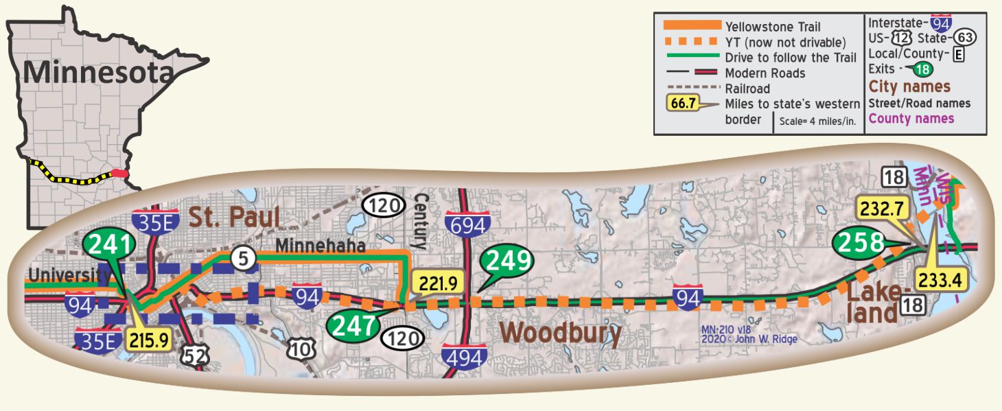
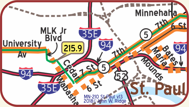 MN-215.9 Saint Paul
population over 300,000; is located on terraces running back from the Miss. River. It is the capital of the state, the oldest city in the Northwest and is a very important industrial and distributing center. The Ford plant covers 186 acres. Visit the magnificent State Capitol, Cathedral of St. Paul, Como Park and the noted city market. The Auto Club is at 4th St. and Smith Ave. Alverdes Restaurant is good, lunch 65c, dinner $1. St. Paul City Camp, in beautiful Cherokee Park, overlooking the Mississippi, 50¢. MN-WPA*
SAINT PAUL HOTEL is finest. Has air of distinction. Splendid large lobby. Sgl., $3-$3.50; dbl. $4-$8; suites up to $15; all baths. Unexcelled dining; lunch 60¢-$l; dinner $1.50; coffee shop. MH-1928*
350 Market St. St. Paul Hotel. From 1910 until today, the St. Paul Hotel has been regarded as one of the nation’s premier hotels. The famous, from Charles Lindbergh to John F. Kennedy, have stayed there. It displays century-old charm and decor along with the modern.
The St. Paul Grill has a startling display of beverage bottles in the bar.
200 Tower Ave. Fort Snelling, originally known as Fort Saint Anthony, was a military fortification located high on a bluff at the confluence of Minnesota and Mississippi Rivers. Built in 1819 to ward off any Canadian or British invaders, the Fort stayed active until 1946. The Fort is a National Historic Landmark. During the summer, costumed personnel interpret life at this early post. GPS 44.89360, -93.18690.
193 Pennsylvania Ave. E. The Minnesota Transportation Museum. In the 1907 Jackson Street Roundhouse, is a fully functional railroad roundhouse, one of the last of its kind in the country. It is highly interactive, offering train rides and hands-on exhibits about surface transportation history of Minnesota. This site has been used for rail transportation since the first railroad came to Minnesota in the 1860s.
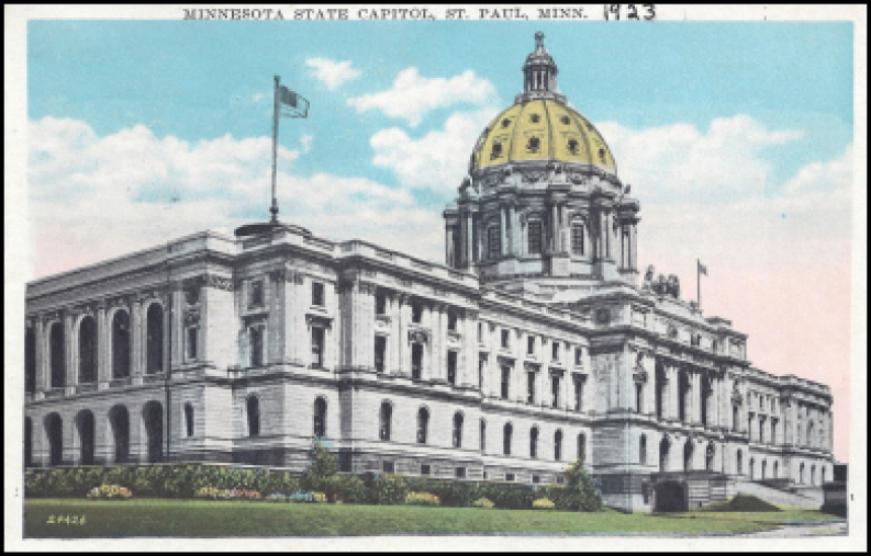
75 Rev. Dr. Martin Luther King Jr. Blvd. The Minnesota State Capitol. (The Yellowstone Trail ran along the west side of the capitol building.) The 1905 domed capitol building, the third and final building for the capital city, features a large, gilded statue of four horses in front of the main entrance. They represent the power of nature: earth, wind, fire, and water.
10 E Exchange St. Fitzgerald Theater (that’s F. Scott Fitzgerald). The Fitzgerald Theater is the oldest active theater in Saint Paul. Built in 1910, it gets rave reviews for “not a bad seat in the house.”
214 Fourth St. E. Union Depot. Begun in 1917 and completed in 1923 (World War I intervened), this station replaced the original 1881 structure which saw as many as 150 trains a day. In 1971, the station saw the last of railways and stood idle. In 2005, the Ramsey County Regional Railroad Authority renovated the station as an intermodal transit hub served by Amtrak trains, Metro Transit light rail, and intercity bus lines. Since its renovation in 2012, the place has hosted special events. Go look at the marvelous space.
240 Summit Ave. James J. Hill House. The rugged stone, massive scale, and ingenious mechanical systems of this magnificent Gilded Age mansion recall the powerful presence of James J. Hill, builder of the Great Northern Railway. The 1891 house has13 bathrooms, 22 fireplaces, 16 chandeliers, a reception hall nearly 100 feet long, and a two-story, skylit art gallery. It was once the largest private residence in the state.
GPS: 44.94540, -93.10930. Pause and enjoy all of the neighborhood. Many old, large historic houses call Summit Ave. home.
~Auto Shows Along the Yellowstone Trail~
↔
“The way to get good roads is for the government to present every intelligent man with a Ford.
The owners of cars are our best road builders.
Let a man buy a machine and he is ready at any time to
get out and work for highways that are a credit to the state.”
Northern Wyoming Herald (Cody), August 20, 1915.
↔
Ah, yes! They are of a piece, those two, car and road entwined like two lovers, needing each other. Henry Ford had been mass producing his Model Ts for seven years by 1915, priced “for the common man.” It was R. E. Olds, incidentally, and not Henry Ford, who built the first operational automotive assembly line. His runabout, also known as the Curved Dash, was the world’s first mass-produced car, built between 1901 and 1907. Any number of other brand names came rolling out of factories to ever voracious buyers. This former “rich man’s toy” had taken hold of the nation’s fancy.
It may have been fine cruising around town at the regulated eight miles per hour, or driving out to the farm at 15, avoiding chuck holes. Detroit even had a bit of concrete. There was a big desire to go distances with the new black beauty on a respectable road. But outside of towns it was a different story. So, lacking that, an auto show was the next best thing to actually going somewhere for boys with their toys.
- The world’s first auto show, the Paris Motor Show in 1898, was founded after the French Automobile Club created an international outdoor motor show that required exhibitors to prove their “seriousity” by driving their cars from Versailles to Paris, says the Historic Vehicle Association Time-line website.
Some other major auto shows in the U.S. during the Yellowstone Trail era were listed by the Historic Vehicle Association:
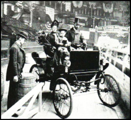
- 1900: An American horseless carriage show was held in Madison Square Garden and drew roughly 10,000 spectators at 50 cents each (about $13 in today’s money). Among the highlights was the appearance of Ransom Eli Olds’ prototype for a new body style known as the “runabout.” It wasn’t the first automobile show held in the United States. It wasn’t even the first held at Madison Square Garden. But it is considered the first modern automotive show. The week long event, sponsored by the Automobile Club of America, featured 66 exhibitors displaying 31 newfangled autos and a variety of accessories to pimp the ride.
- 1901: The Chicago Auto Show opened for eight days in the Coliseum Exposition Hall. Over 4,000 spectators attended. Prices for exhibit space on the main floor ranged from $1.00 to $1.50 per square foot.
- 1907: The Detroit Auto Show, renamed the North American International Auto Show in 1989, was first held at Beller’s Beer Garden in Riverside Park.
- 1910: Detroit’s first Auto show was held at the light guard armory in 1899, but the 1910 show was something of a landmark. It was the first time that many of the vehicles were exhibited complete with all of their equipment for the customer.
- In 1924, a new convention hall was completed at Woodward and Canfield in Detroit. “Some automotive historians said that the hall contained more exhibition area on one floor than any other showplace in the country,” wrote Robert Tate in The Detroit Auto Show: A Brief History of Style and Innovation published on the Internet 1/29/2020.
- 1912-1913: The first detachable steering wheel and electric headlights drew a curious crowd at the Detroit Auto Show.
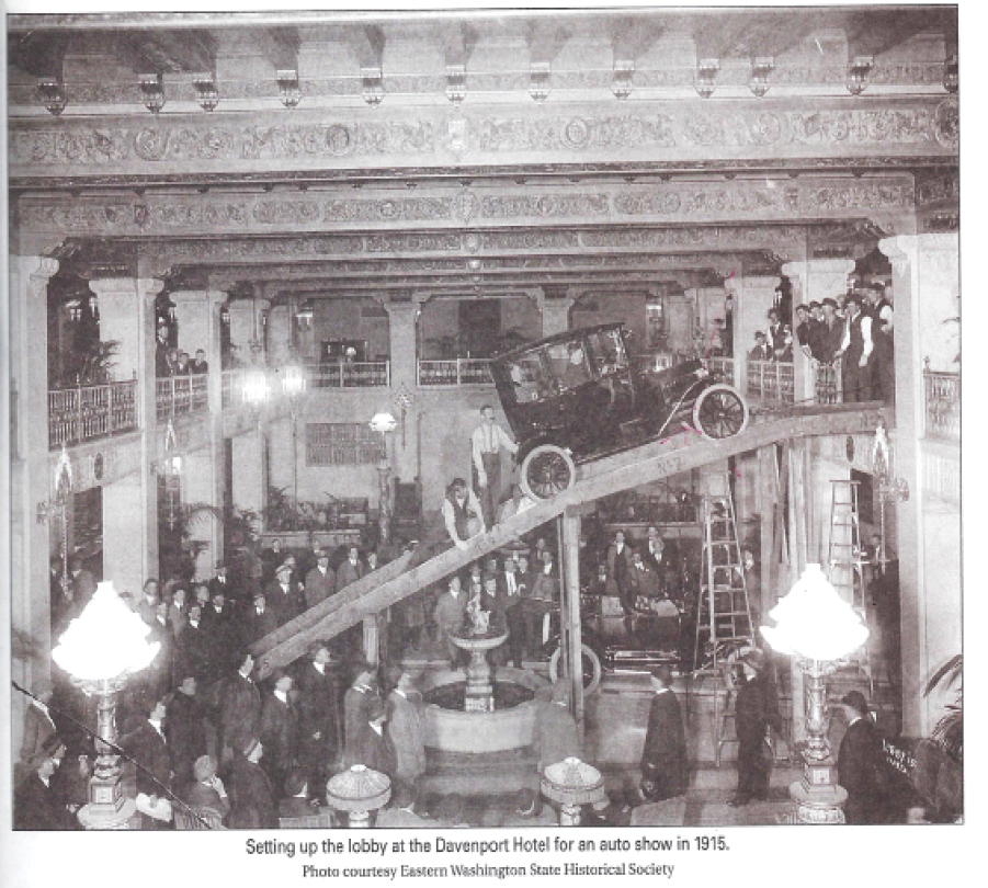
- 1915: Davenport Hotel, Spokane, Washington (see photo)
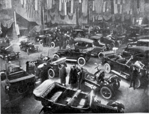
- 1917: Billings, Montana (see photo)
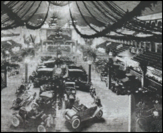
- 1919: Milwaukee at the state fair (see photo)
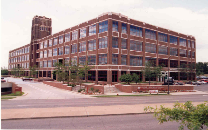
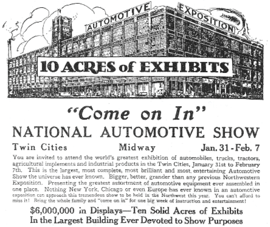
- 1920 January: 2550 University Ave. between Minneapolis and St. Paul is the large Willys-Overland building built in 1915 for automotive shows. It was modestly billed as “the largest, most complete, brilliant and entertaining Automotive Show in the universe.”
Today the remodeled building houses offices.
Click here for current location of old Willy’s-Overland building.
- 1924: Milwaukee’s 16th Annual Auto Show at the Milwaukee Auditorium.
- 1933: The Pierce Silver Arrow, a concept car designed by James R. Hughes, was introduced at the New York Auto Show.
![]()
Motor Age listed the coming auto shows and contests for 1914. Six of the 17 shows were held in Europe and Canada, and 13 of the 34 contests were not in the U.S. (mostly in France). But that list shows a veritable boiling pot of interest in everything auto on two continents.
Headlines such as STATE FAIR AUTO SHOW THIS YEAR A $1,000,000 DISPLAY heralded the coming of the 1919 auto show at the Milwaukee State Fair appearing in newspapers in 1918. The ads allayed fears of shortages caused by World War I, saying, “Despite rumors that have been given nationwide circulation, production of passenger cars will be continued at an output as nearly equal to the demand as supply of labor and material will permit.”
Continuing on, the ad added, “The State Fair Auto Show will be held in the Automobile Building as usual. It is impossible to make the Auto Show any bigger this year than last year, for the reason that the display of motor cars is confined to the Automobile Building, the largest structure on the Fair grounds, no other space being available for expansion.”
Colby Phonograph (Wisconsin) September 5, 1918.
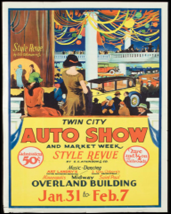
A widely advertised auto show as “the world’s exhibition of automobiles” was the 1920 National Automotive Show between Minneapolis and St. Paul in the Willys-Overland Motor Company building. $6,000,000 in displays, 10 Acres of Exhibits sang the headlines. “Largest, most complete, better, grander” were just some of the hyperbolic encomiums littered about by the press to describe something more than just a show of autos. Farm equipment, Vaudeville acts, live orchestras, style shows and, to attract the ladies while their husbands ogled the new Oldsmobiles or Packards, washing machines, food shows, vacuum cleaners, etc. You get the picture.
The Twin Cities did not act in a cooperative way until 1918 at the Willys building. Previously, each city had held its own event. The joint enterprise became very successful, advertising “double the exhibits.”
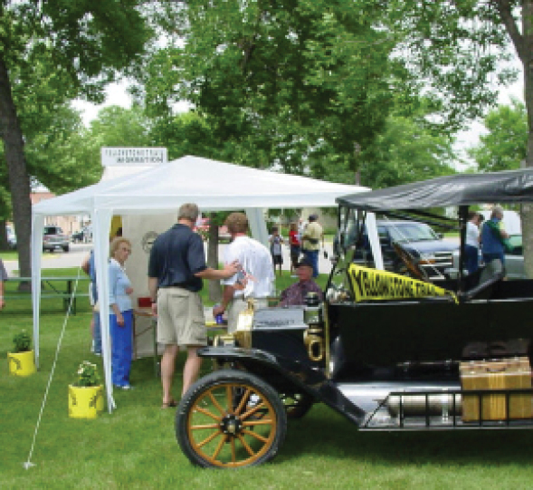
We do not know if the Yellowstone Trail Association produced an exhibit in other auto shows held along the 3,600 miles of Trail, but we suspect they did. Not many publicity opportunities were missed by General Manager Hal Cooley. The Association did make it to a Twin Cities show because Cooley profusely thanked them for display space in the following paragraph in the 1922 Western Magazine:
Due to the courtesy of the management, space was provided in the Twin City Automobile Show held February 4-11 for an exhibit and information booth of the Yellowstone Trail Association. On display was a section of the Trail across the continental divide near Butte, the majestic Rocky Mountains being worked out in bold relief, and showing the New Davis Grade crossing the main range with only a 4% climb. Photographs by J. E. Haynes Co. of Yellowstone National Park were shown through their kindness. The rest of the exhibit was made up of a display of Trail literature, markers, and publicity features. The Association desires to express its gratitude to the Automobile Show for the kindness shown.
Today, the famous Detroit auto show was canceled for 2020, perhaps for the first time in its over-100 year history, due to the coronavirus. Now called the International North American Auto Show, Wikipedia described it as, “… among the largest auto shows in North America and is regarded as the foremost venue for [car] manufacturers to unveil new products.” It will resume in June, 2021 in Cobo Hall where it has been for 55 years.
Two major car shows beat the coronavirus: Los Angeles in late November, 2019, and Chicago in early February, 2020, just before all gatherings were canceled. New York’s show scheduled for late August-early September, 2020, has been canceled.
The reader may conclude that public health concerns beat America’s 120-year love affair with the auto.
A Mystery at the Museum
[A note about researching the Yellowstone Trail]
While researching the Yellowstone Trail, our visit to the Hennepin History Museum in Minneapolis, Minnesota, yielded an unexpected and mysterious short article: “The Yellowstone Trail Markers.”
It is in the Summer, 1963 issue of Hennepin County History, p. 23. The article is a report, with pictures, of a “recent” visit to several nearby Yellowstone Trail route markers. The pictures in the article were taken from along West 22nd St. along Blaisdell and at Pillsbury and Pleasant Avenues. Our modern boots-on-the-ground search found no trace of those markings.
The mystery?
Our inspection of all available Yellowstone Trail Association publications and papers always had reported a Hennepin Ave. route, as did several Automobile Blue Books.
Bewildered, we re-opened the search for the Minneapolis route. By that time we had collected later Blue Books and they showed the Blaisdell route. “Officially” or not, the route had been, de facto, changed to the “new” route on Lake, Blaisdell, and Nicollet (pronounced Nick-o-let locally). Mea Culpa.
Oh, and the General Manager of the Yellowstone Trail Association
might easily have followed the newer route between his home and
his office in downtown Minneapolis.
Just sayin’.

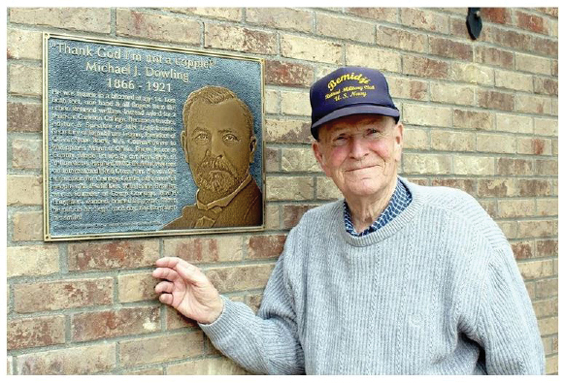
Michael Dowling about 1919, Renville County Dowling-for-Governor Club, Olivia

This photo of Michael Dowling, showing his prosthetic legs, was taken in 1920 by Lee Bros. Photography.
Photo by the Minnesota Historical Society.
Trailblazer Dowling ~ “Thank God I’m not a cripple”!
It was cold and raining that April day of 1921, but that was to be expected in spring in Minnesota. The weather didn’t matter to the hundreds who had come to stand silently outside of the house on Olivia’s DePue Avenue. What mattered was that a good man had died and they were there to pay their respects.
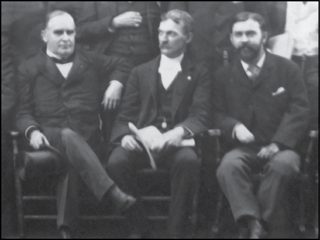
Michael Dowling had cast his net widely in his 55 years. He had become known in the worlds of politics, good roads, education, newspapers, banking, innumerable charities, wounded WWI veterans, and the Yellowstone Trail Association.
A true Renaissance Man, he.
Tragedy
In truth, he should have died 41 years earlier when, as a boy of 14, he got caught in a blizzard and froze both his legs and left arm and some fingers of the right hand.
In that rude farmhouse where he sought refuge, gangrene set in, forcing the doctor to saw off the affected limbs below the knees and elbow.
But he didn’t die.
Instead, he boldly asked for and received false limbs and a year at Carleton College and swore he would not be a ward of any county for the rest of his life.
His accomplishments would take pages to recite.
They are detailed in his papers held at the Minnesota State Historical Society.
We will mention only two aspects: politics, and good roads and the Yellowstone Trail Association.
He was a fearless Irish advocate in all the causes in which he believed, with a ringing voice and a ready wit. His life was an inspiring one; his mantra, “Thank God, I am not a cripple!”
Dowling’s Political Life
Politically, he was a Republican, becoming Speaker of the Minnesota Assembly, then secretary of the National Republican League and, thus, came to the attention of President McKinley.
The Spanish-American War (1898) was a war against Spain’s colonization of the Philippines which the U.S. joined. Later (1899-1901) the independent-minded Filipinos fought the American intrusion.
In 1900 Dowling went to the Philippines at the request of McKinley to investigate the school systems there and prepare a plan for schools which the U.S. Army could carry out. There was a whiff of suspicion about that mission, implying Dowling was to spy for the U.S. which he vigorously denied.
Dowling’s six months there resulted in 10 articles for the Minneapolis Journal and many letters home.
Barry Prichard, Dowling’s grandson, has produced a valuable book, Bolos, Bandits, and Bamboo Schools (Richards Pub. Gonvik, MN, 2009), which is a compilation of those writings and a good history lesson.
The Philippine experience also produced a comic opera based upon a true story of Dowling’s appearance before Sultan Sulu.
- The Sultan was not attending to Dowling’s discussion of schools, so Dowling slowly removed one of his false legs.
- That got only a glance from this “self-made king.”
- Dowling removed the other leg. This got a longer glance.
- Then off came the right arm and a twist of his neck as though to remove his head.
The Sultan finally laughed and attended Dowling’s discussion.
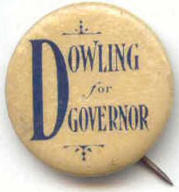 On the surface, his political career after his stint in the Minnesota Assembly may look like failure.
He did not win his run for the U.S. Senate seat, nor the Governor’s chair, nor a close run for Congress vs Andrew Volstead (author of the 18th amendment, Prohibition).
However, these forays led him to meet and work with people like himself, “movers and shakers” of the broader issues he cared about.
A Good Roads Man
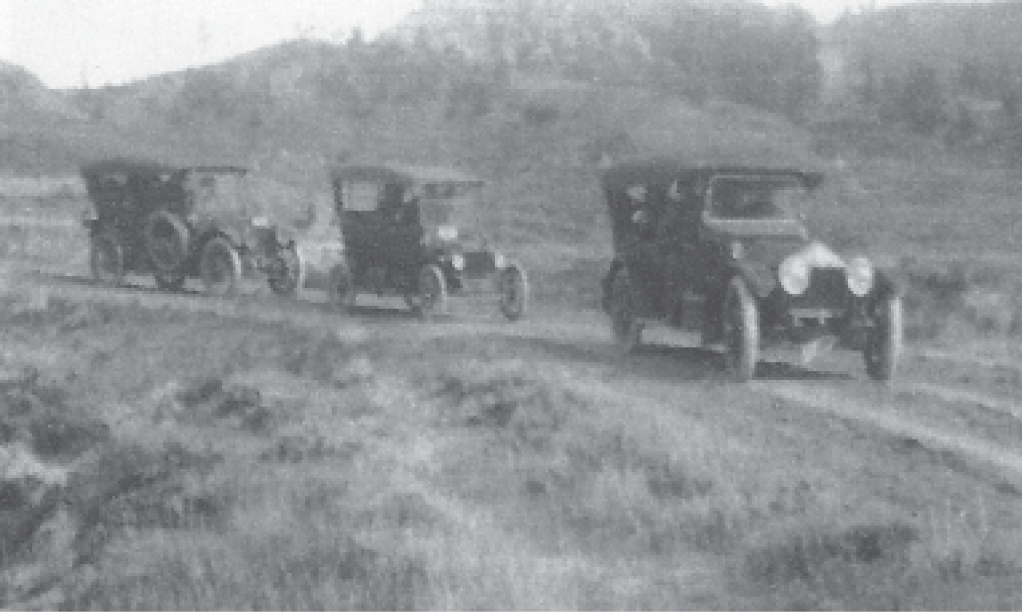
As an auto dealer in Olivia, Minnesota, and owner of the first car sold in Renville County in 1902, Dowling had foreseen the role of the auto in the development of 20th century America. He knew the value of roads as an absolute economic and cultural necessity which the federal government was ignoring. For instance, in 1910, before the Yellowstone Trail Association was born, Dowling directed Renville County’s winning participation in two “Best Roads” competitions. The Minneapolis Tribune sponsored the events as a way to inspire localities to drag their roads, drain their ditches, and push for graveling. The reward was bragging rights and a trophy (see photo).
The Yellowstone Trail Association caught Dowling’s imagination. He determined to drive the Trail along the whole of its barely discernible 1913 route from Minnesota to the Yellowstone National Park. He wanted to be the first to “blaze” the route that the Association had drawn on a map, to advertise it, and prove it could be done. It then consisted of grassy wagon trails, farmers’ muddy section lines, and mountain grades, with only about 120 miles graveled. Predicting that such a trip would be “safe, easy to traverse, and affordable” was stretching optimism remarkably.
So he piled his wife and three daughters into his especially equipped (right hand wheel and electric starter) Oakland 660 and, with two other families along, led a three-car caravan to the Park. Fording streams, wading through mud, and fixing punctures occupied the party, but they did it! They returned to welcoming ovations in Olivia. Such travel was considered extremely dangerous.
Recalling that trip five years later, this great optimist quipped, “If a man with one arm, a wife and three daughters could make such a trip, anyone could.”
Although the Association would not be expanding its route to the east for a year or two, Dowling jumped the gun and “blazed” the idea of a trail to Plymouth, Massachusetts in 1914. He took short cuts, but he did get the lay of the land.
He shipped his car through the Great Lakes to Buffalo, New York, and began looking for a space to locate the Trail on the popular Rochester-Albany-Boston corridor.
He was told that “there was no more room for colored markers on poles on that route.”
Indeed, eleven different trail colors festooned some poles already. He then traced a more southern route: southern New York to Hartford, Connecticut to Plymouth Rock. This was the route taken by the relay teams in the 1916 race from Plymouth Rock to Seattle.
Dowling’s grandson, Barry Prichard, published the detailed notes and pictures kept by his mother about those two historic trips in We Blazed the Trail (Richards Pub. Gonvik, MN, 2009). Buy this book in our online “Shop” at www.yellowstonetrail.org.
During his tenure as Yellowstone Trail Association president (1917-1918), Dowling:
- oversaw the establishment of at least ten tourist bureaus which gave out information to Trail travelers;
- approved the incorporation of the association;
- saw the northern route through the east, which was refused to him in 1914, become a reality;
- spoke at all state and national Yellowstone Trail Association conventions.
The calamity, which would have diminished lesser men, brought out Dowling’s strength of character.
He led an incredible life, and was an integral part of creating and popularizing the Yellowstone Trail.
This remarkable man invigorated the Yellowstone Trail Association as no other had.
His very appearance inspired resolve among the membership as he repeated, “Thank God I’m not a cripple!”
The authors wish to thank Barry and Michael Prichard, Michael Dowling’s grandsons, for their assistance.
↔
Travel Diaries and Hoopla in the Press
B. J. Danielson wrote this diary (below) during his 1927 camping trip west in his Ford named Rocky.
His full diary exposed a man of humor and infinite patience.
Danielson Diary Entries:
July 1:
12:00 p.m. Bought Ford
4:30 p.m. Wish I hadn’t bought it
July 17:
4:30 a.m. We get up and repair tires. By 6 o’clock we are on our way
8:30 a.m. Sunday morning when we should be praising the Lord, we are praising a flat
12:00 noon St. Paul, Minn. It’s high time we were fixing a flat tire … again.
July 18:
5:30 p.m. There is a mule colt in the road ahead of us. No, beg your pardon, it’s a jackrabbit.
July 19:
9:00 a.m. Just crossed the Missouri River at Mobridge.
Rough detour on dirt road. These roads are like sponges in wet weather and rocks in dry.
8:30 p.m. We are driving in the face of a bad looking thunderstorm.
The prairie is fiery with lightening and we are trying to make it to the next town.
9:30 p.m. The storm has broken and we are marooned on the prairie.
Both the wind and rain are terrific and our old bus is about ready to topple over.
We manage to skid along under the shelter of some hills
where we spend the night with the wind howling like a hungry coyote.
↔
For centuries, hand written accounts of people’s experiences were more than just words. Writing style, drawings, and blood, sweat and tears left on paper gave detailed insights into the writer. The same can be evident in a trip diary. Letter-writing and journalism seemed more popular and necessary one hundred years ago, so keeping a diary while traveling was probably more naturally done.
Today, cell phones can record a travel moment visually and audibly with just a click; a phone call can replace written description.
A Twitter communique of only a few characters can transmit the basics of who, what, where, when.
But……. to see what the traveler saw requires words, an attitude, and a mood of the diarist.
To the student of history, diaries are golden primary sources, written close to the action. One hundred years ago writing took time and a more active participation with words, possibly revealing more than intended by the writer. Long-distance travel was fairly new then, so trips that were made were sort of an understood benchmark in that family’s story, demanding a more full account. However, trip diaries did not always assure complete accuracy.
Some may have exaggerated the dangers due to fright at the moment. Some, because of frustration or anger, may have exaggerated the number of flats they had that day or the ferocity of rain. Waiting for three days for auto repair parts to arrive could surely make one frustrated. In their own words, long ago travelers on forgotten roads teach us about our culture.
The trip diaries kept along the Yellowstone Trail that we have come upon in our research showed us that trip “diaries” come in various forms. Some were kept literally day-by-day, some appeared as a series of post cards sent home, some abbreviated diaries appeared in newspaper articles submitted by returned travelers or were sought after by reporters. Some formed the bases of articles written as advice to potential travelers.
All of the diaries that we found referred to traveling to or from the west. No one seemed to have written about their travels east. Could it be that the roads were better there and, thus, not worth writing about? Picture post cards of historic sites seemed more important to verify one’s trip east than hardships on the road.
Whatever the form of the missive, the diaries we have seen seem to gel around a few themes. The leading topics were problems (with auto, road, or lack of map), descriptions of surprising events, or of the scenery.
Problems, Problems
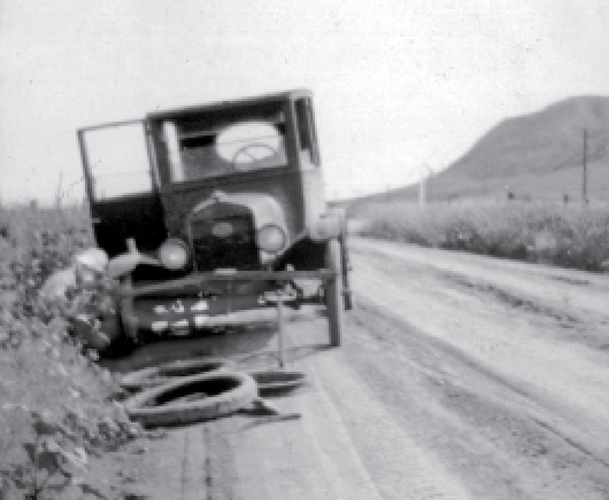
Paul G. Hoffman, president of Studebaker Corporation, told about a “long” 60 mile trip from southwest Chicago to Hobart, Indiana, in “America on Wheels,” a chapter of Winifred Dixon’s Westward Hoboes (1921). He, his parents, grandpa and aunt were well equipped for the journey with extra spark plugs, inner tubes and casings, springs, tools, and lunch. They started on a Saturday morning, but never made it to Hobart.
Hoffman wrote:
I tried to shift from third to second gear to climb a hill and failed. When the car was out of gear there was no service brake. We started to roll backward. My aunt screamed, tossed out the lunch basket, and followed it herself in a flying leap. … we reached a fork in the road, and we had no maps. We went right. We should have gone left. It began to rain. Considerable time was lost in putting up the curtains. The road became a bog into which we sank. I cut brush to give the wheels traction. We got out of the first mudhole, in a short way we sank again.
They stayed at a friendly farmer’s home overnight, turning toward home the next morning having gone 45 miles. Grandpa seriously gashed his forehead on the radiator. Crankcase oil leaked out and the engine froze. The ladies got on a streetcar and went home.
The Ross family account of crossing Snoqualmie Pass before the Yellowstone Trail arrived included:
This required the car’s seven passengers to hoist the vehicle up the steepest grades by hand via a pulley system devised with 200 feet of rope and the sturdiest tree we could find.
In the Marmarth, North Dakota area, we read from Arthur Williams that:
… that was a dirt road. You shouldn’t travel it in the rain. Not even our old Model T could get through. That gumbo mud built up on our wheels and it was just like you had the brakes on.
The tale of gumbo was repeated countless times on and off the Yellowstone Trail. Tales of tipping over, meager camping facilities, negotiating hills backwards (to favor the gravity-fed gasoline supply), and treeless North Dakota and eastern Montana garnered the most ink along with road and auto troubles in diaries.
… And Yet They Endured
The Yellowstone Trail seemed damned about as much as it was praised in diaries. Allen Cooper, speaking about South Dakota’s Standing Rock Reservation, said:
The road traveled was the Yellowstone Trail. None of it was paved; all of it was poorly marked.
In many places the only markings were smears of yellow paint on fence or telephone post.
And R. S. Spears wrote in Outing Magazine Vol 68, 1916 about his motorcycle trip to the Yellowstone Park and his problem of no Yellowstone Trail signs in Minneapolis:
I do not know of any more trying experience than seeking a road out of a city with such picturesque and winding streets as those of Minneapolis. With a map of both the Twin Cities before me, I am quite unable to discover my route. I saw no signs for the Yellowstone Trail and people could not give me understandable directions for finding it. I know I crossed the Mississippi twice! “Just keep a-goin” until I run into the Lakes, or Lake Ave. or something. Or “You can’t miss it. Not after you turn right, go around the lake then hit, let’s see four? blocks out. Then you’re all right.”
… Oh for some signs!
Conversely, we read from Mrs. Anna McKee of Minnesota about a 1920 trip through northern Illinois and Iowa:
I am proud of the Yellowstone Trail as it is the best highway I have traveled on. The Jefferson and Lincoln Highways are good roads but work on the latter trail necessitates constant detouring. We passed over hard surface roads for a distance of 40 miles in some instances.
And Edgar Wilcox, in Haggerty’s Car Culture 1923 announced that:
The Yellowstone Trail is well marked – a yellow square (about 16″ square) bearing two black circles between which are the words “Yellowstone Trail” and in the center a black arrow pointing to the Park. The sign came to be a faithful guide and friend to us in the hundreds of miles that we followed the trail to Spokane.
Troubles seemed to overshadow the descriptions of the beautiful scenery or the Yellowstone Trail, but yet they saw things. Descriptions allow us to see what travelers saw and endured.
Descriptions
An unknown (to us) writer recalled a trip in 1922 from Cheyenne, Wyoming, north through western Montana and Washington, then down to their new home in California. This diary mentioned Butte, Missoula and camping at a small town on the way to Spokane.
They were most likely on the Yellowstone Trail.
He wrote,…
“My mother wrote such an excellent account of the trip west in those times that I shall not cover it.
This is her wonderful account of our trip.”
The following is just a bit of her description.
Sat. eve drove thro’ mountains and mountains, around curve after curve & hairpin turns – one place where just as we reached the bottom of one hill it turned and went down in just the opposite direction & big cars all have to stop and back a little to make the turn. Fords and Maxwells can make it without. Of course there’s a sign before you get there telling you it’s coming & there’s a railing around it so you can’t jump off. And the figure 8’s and S’s we did cut. Such roads – but it’s certainly wonderful that they can make roads at all in such places.
Notes from an August, 1914, trip from Minnesota to the Yellowstone National Park were submitted to the Winona Republican-Herald upon the family’s return by E. M. McLaughlin:
From Huron, South Dakota, we went to Aberdeen. There we got on to the real trail to the park, called the Yellowstone Trail. It is marked with yellow posts and across the prairie with yellow stones. The roads are good in Minnesota and eastern South Dakota. In the western Dakotas and eastern Montana there are only grass trails with lots of stones and holes. Lots of new roads are being made across Dakota and Montana, so the trail takes temporary routes, sometimes fifty miles from a railway and fifteen to twenty from a house. The Little Missouri River has to be forded at Marmarth, but when we crossed, it was so swollen by rain that it could not be forded by teams to say nothing of autos, so we crossed on the railway bridge.
William C. Bettis had a different goal from most for keeping a diary in 1921. He was apparently a professional traveler who sold his travel booklets and who appeared on the lecture stage. Mrs. Bettis took notes, noting the good and the bad. A trip to the Pacific Coast carried the reader with them from Toledo to California. The booklet is heavy on description and advice, but there is little bad about the Yellowstone Trail, except to say that there are several detours due to road work. One exciting description of his trip, written as though to experienced travelers, follows:
There are a lot of experiences you would have had by this time also. For example, you may have been high up on a shelf road, one of those roads cut into the side of a mountain. You are away up among the clouds, a sheer mountain road towering over you on one side and a drop of hundreds of feet on the other. This road may be wide enough for just one car with nothing to prevent you from driving into the chasm. With both feet on the pedals and a death grip on the wheel you are swinging in and out around short, sharp curves, and suddenly you see a sign that reads PREPARE TO MEET THY GOD. No matter how experienced you are, this will send a shiver up your spine.
Unusual Tales
When something unexpected happened, the diarist was sure to include it.
Chances are that the surprises are what people remembered the longest. This tale hit the Antique Motor Cycle magazine, summer 1999, about something that happened back in 1922, as told to his son by Allen Cooper (again). It revealed a happening on the open road – stranded parties. Cooper was on his 61-inch Harley-Davidson.
We excerpt his tale here of stopping in western South Dakota as an example of kindness on the road 100 years ago:
- There were few habitations and fewer gas pumps in the stretch between the river and McIntosh.
- Miles out on this barren and deserted road a parked car showed up.
- Four men in work clothes flagged me down.
- Their old Chevrolet touring car bore Pennsylvania license plates.
- Their car had quit on them suddenly, “like we had turned off the switch.”
- They were laid off coal miners on their way to the Butte mines for work.
- It was plain they were on a close budget. None of them seemed to know anything about a car except how to drive it.
- The prospect of a big towing or repair bill could not have depressed them more.
- I asked to look at it.
- They readily agreed.
- It appeared that it was ignition failure.
- A wire had broken off right next to the battery.
- A few minutes’ work stripping off some insulation and clamping the bare wire under the cable clamp completed the circuit.
- I had never seen four happier fellows.
- They insisted they owed me something, but my reply was perhaps they could pass on the favor to someone in trouble.
↔
A diary kept by Montana’s Spencer “Bill” Lauson c.1921 suggests that long-distance travel wasn’t quite as we expect it to be today:
- My brother Dwight said I was welcome to ride with him and his family from Billings to Chicago.
- I looked out the door and saw that the reconditioned Studebaker was filled to the roof with baggage, with only a small space left for the family dog.
- In addition to the three members of my brother’s family, an oversized lady with her teenaged daughter planned to ride for the first 150 miles – all five of them jammed in the front seat.
- I didn’t fancy myself sitting on the fat lady’s lap.
- ‘I think you could sit on the front fender’ my brother casually suggested.
- If I were to save money on my travel, this would have to do.
- I carried no luggage – there wasn’t any room – except for a towel, soap and razor which I had hastily stuffed into my pockets.
- I had little idea how futile these cleanup efforts would be in the war against dust, grit and mud.
- Shortly after we passed the outskirts of Billings it began to rain.
- We were following the old Yellowstone Trail which would take us to Chicago.
- The road turned into a slippery gumbo, and the old Studebaker would slide and fishtale as it hit a stretch of the unpredictable mixture of clay and rain.
- I hung on to the fender with white knuckles, trying to dodge clumps of mud that were thrown from the car’s wheels.
The last unusual happenstance occurred in 1923 and was recalled by Lydia McKay.
- She and three other women were returning east to Brainerd, Minnesota, in a Star automobile after a 13-state tour.
- Two women occupants of another car were traveling west, beginning a tour.
- As was the custom then, McKay stopped to chat with the other woman driver.
- What a surprise! They were all from Brainerd and met purely by chance on the Yellowstone Trail in South Dakota.
- Pictures were taken of the surprising event, tales of broken tie rods and poor roads were told, and tires were kicked.
- Attesting to the generosity of people, McKay reported that at one point the foursome saw a rainstorm approaching on the prairie.
- They simply drove into a nearby farm and asked to spend the night on the farmer’s porch out of the rain.
- Consent was cheerfully given, followed by dinner and breakfast for the travelers.
Hoopla
Because long-distance travel was not usual, when a touring party reached town, frequently there was a big greeting awaiting them. There was the crowd greeting the Michael Dowling party of three cars as they arrived home from their 1913 Yellowstone Trail trailblazing trip. See Trail Tale: Dowling.
Some local newspapers seemed more intent upon recording the local greeting offered the travelers than upon the trip reported by the travelers.
Only a year before the Yellowstone Trail arrived, we see in the Minneapolis Tribune of Aug. 30, 1911, how an auto tour was received in Minnesota:
- Officials of the St. Cloud Automobile Club piloted the tour to Clear Lake where the pilot car stopped for tire troubles.
- At Anoka, R. A. Cooper and Dr. E. A. Lyman in the pilot car were met by a delegation of five automobiles from Minneapolis.
- Among those who welcomed the visitors were H. J. Clark, president of the Minneapolis Automobile Club and G. Roy Hill, secretary.
- A special car from the Minneapolis Tribune met the tourists first, giving them copies of the morning editions in which were full telegraphic accounts of the tour.
- Officials of the Veerac Motor Company piloted the tourists through the factory where the ladies were given roses and the men cigars.
After such a reception given the tour group in Anoka, we can only guess about the hoopla which awaited the group in Minneapolis. We have no information.
From Diaries into Books
Frank L. Wentworth turned his six year camping trip into a fascinating 436-page book, On the Road With Lizzie (his affectionately named Model T). Frank crossed the nation several times between 1924 and 1930, seemingly choosing the route as his mood and the weather dictated.
He moved about unhurriedly, spending weeks at single campsites, absorbing the environment and those who moved about him.
Wentworth thanks his three daughters for help in preparing the book.
Considering the amount of minute detail and the names of people he had met, he must have kept a careful diary which his daughters may have unraveled with him.
Another interesting book appeared in 2008.
Dorothy was just a girl when her father, Yellowstone Trail trailblazer Michael Dowling, took his family west in 1913.She kept a diary, complete with pictures.
Her son, Barry Prichard, and she turned that diary into the book, We Blazed the Trail.
The reader can get a good view of that exciting adventure along uncharted tracts of land through pictures and through the eyes of a 13-year-old.
Earnest N. Smith, writing in American Motorist, December, 1925, described his latest run from Vancouver, B.C. to Chicago, one of several transcontinental trips he had taken.
He concluded with this poignant paragraph:
“But best of all it … [the TRIP]
helped me see our country as I had never seen it before.
It had given me a schooling,… a patriotic education.”
There came to mind the sentiment of the ancient traveler of Rome who, returning after a long absence, said:
“I am a part of all that I have seen.
And all that I have seen is part of me.”