
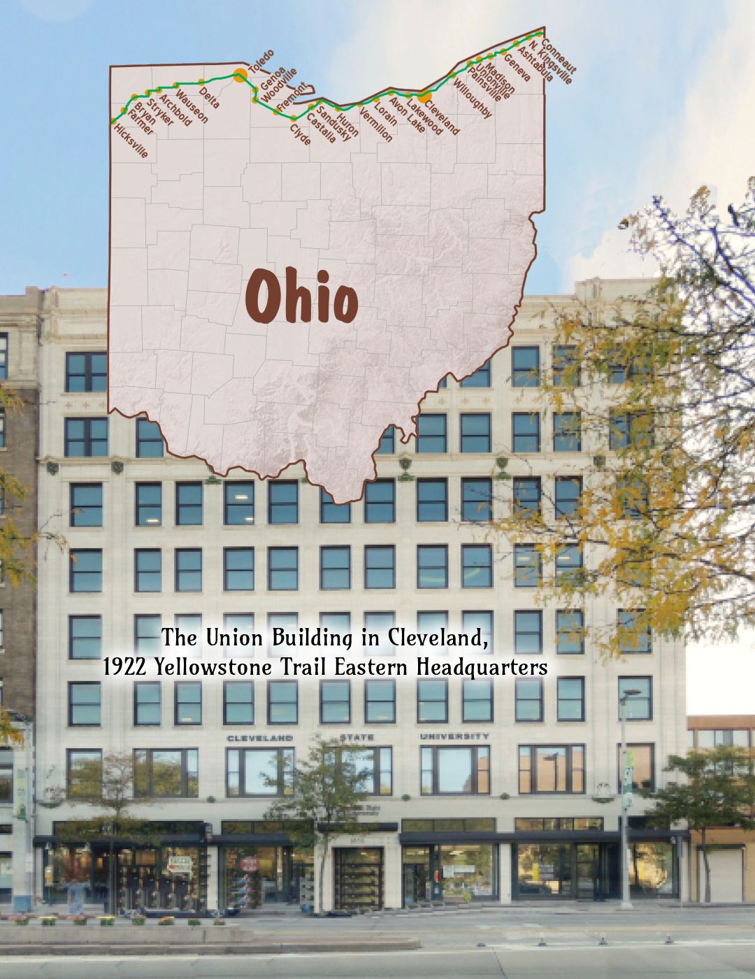
 The map’s green circle markers
are modern highway exit numbers
used for current location reference.
 The map’s yellow rectangle mile markers show path of YT and distance to state’s west border. Click the corresponding number in text for directions and more information.
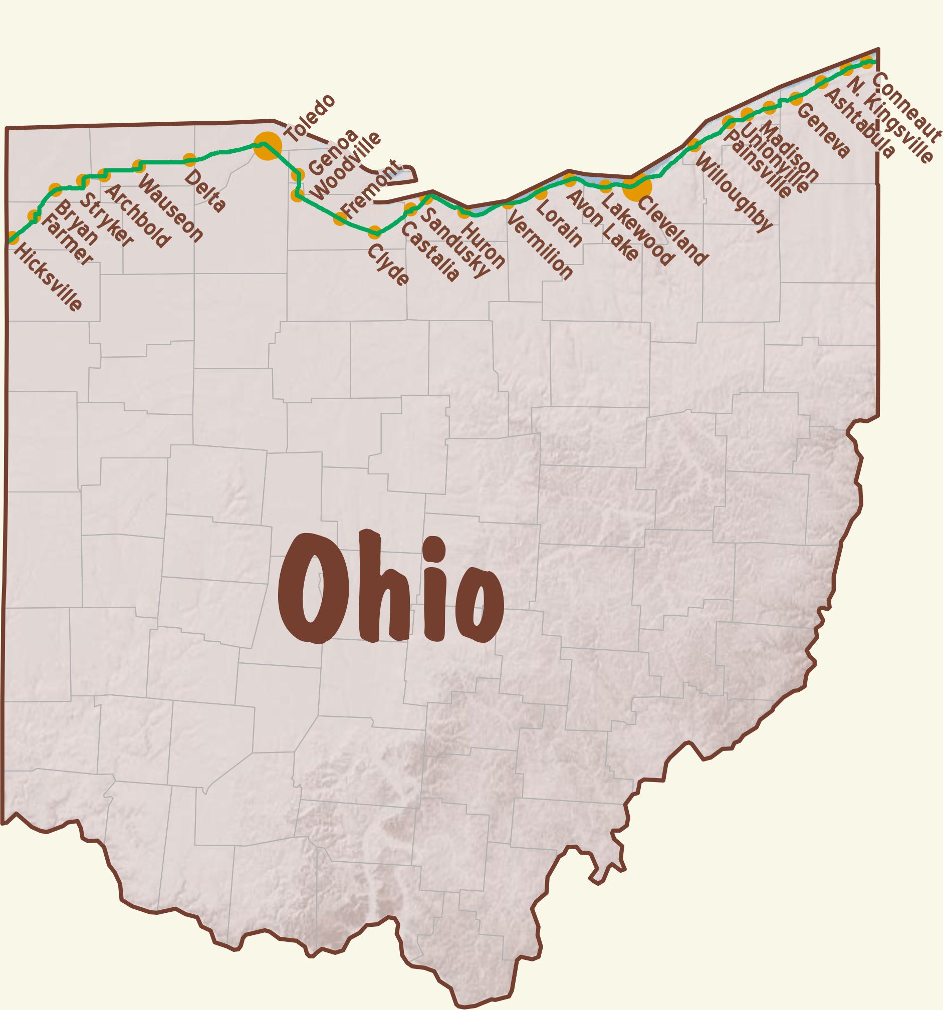
 For Directions, click the Ohio YTA Mile Marker Numbers (below) linking you to a real-time map.
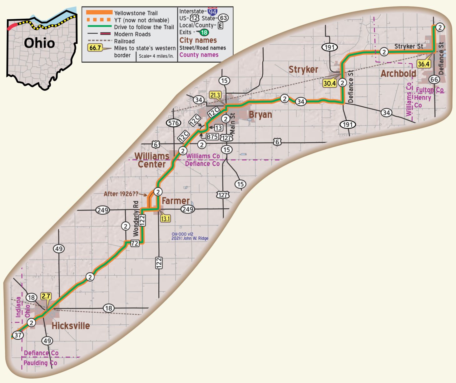
OH-002.6 Hicksville
(754 alt., 2,445 pop) a busy shipping point for farm and dairy products in the center of a melon- and tomato-growing district. It supports a canning factory, a cigar factory, two wood-working shops, and two grist mills. WPA-OH*
W High St. (Yellowstone Trail/US 2). The Land Office (1837). The Land Office is so named because in 1837 the Hicks Company of New York sent A. P. Edgerton to sell its 140,000 acres of land in Hicksville. He built a one-story square land office in the Greek Revival style and developed the land from swampy forests to good farmland. It currently houses Hicksville Historical Society collections. Read more here at Hicksville Historical Society website.
OH-021.3 Bryan
(pop. 3,641, alt. 764 ft.), the county seat of Williams county, was established as such before any town existed here. The town is situated on a ridge which is supposed to have been at one time the shore of Lake Erie. Bryan is sometimes called the “Fountain City,” because of its many flowing artesian wells. BB-1920v4*
From west of Toledo to northwest Indiana to southern Michigan through Bryan extended the Black Swamp—a wasteland 120 miles long and from 20 to 40 miles wide, thickly forested and filled with malarial bogs and pools of water. Immigrants gave it a wide berth as they pushed on toward Indiana or Illinois. An early surveyor made this entry in his journal: Water! Water! Water! tall timber! deep water! Not a blade of grass growing, nor a bird to be seen. WPA-OH*
Extensive reclamation work was carried on during the latter half of the century as farming proved a profitable undertaking on this virgin soil. Today the only reminders of the blight that once infested the region are the parallel rows of drainage ditches running across the fields like strings on a harp. WPA-OH*
Communications from Fort Wayne, Indiana, through to Sandusky speak of the Black Swamp. The authors lived in the area for a year and saw nothing deleterious. All we noted was the rich soil and the vast tomato crops which drew seasonal pickers for the Heinz ketchup factory.
One Courthouse Square, corner of High St. (Ohio 2, the Yellowstone Trail, and Ohio 34,) and Main St. Williams County Courthouse.
The Romanesque courthouse with its high clock tower was built in 1888 and is listed on the National Register of Historic Places, and it is part of the Bryan Downtown Historic District roughly bounded by Walnut, Beech, Maple, and Bryan Sts.
400 N Portland St. Spangler Candy Company. Established 1906 first as a producer of baking powder, baking soda, and corn starch at 204 W High St. By the time the Yellowstone Trail passed by on High St. in 1916 travelers could also buy candy. Over 100 years later a traveler can now visit the Portland St. factory for candy and for a tour.
OH-030.4 Stryker
115 N Depot St. Stryker Depot built in 1900, is on the National Register of Historic Places.
The Depot houses the Stryker Area Heritage Council Museum.
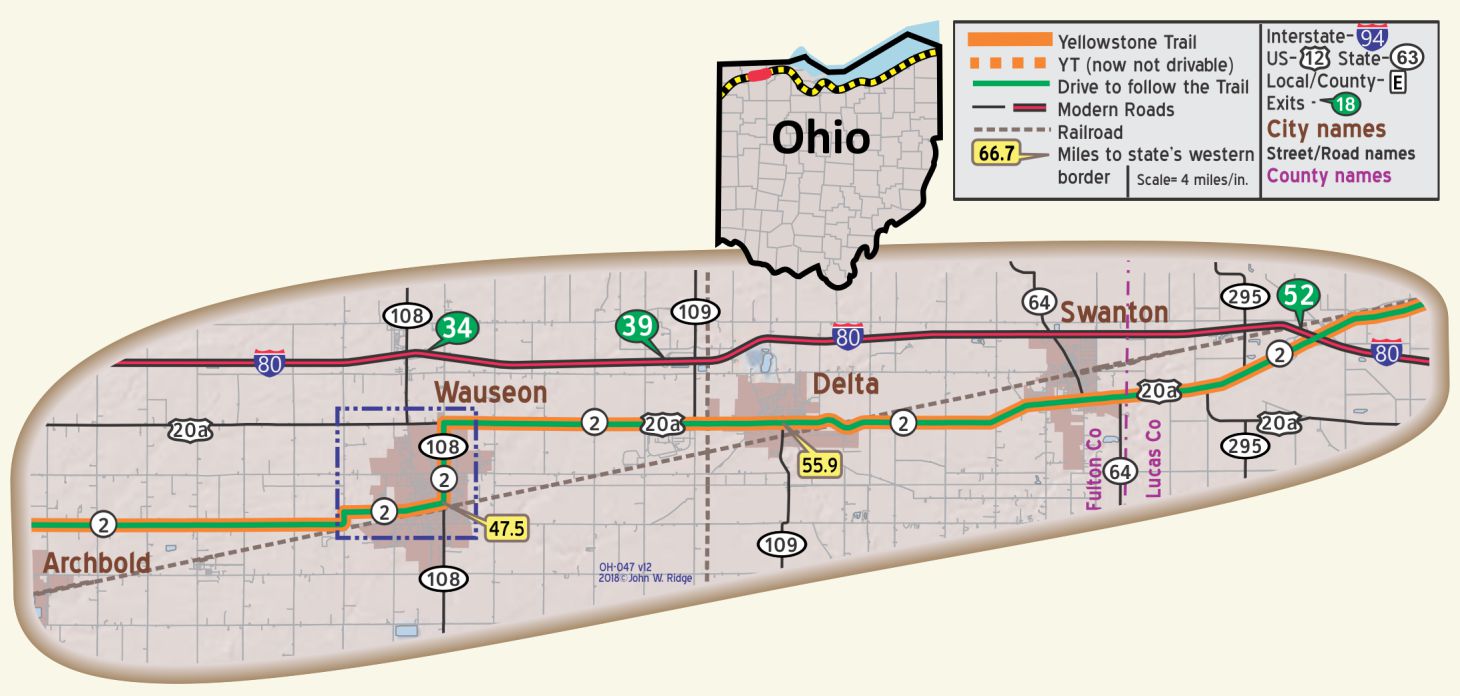
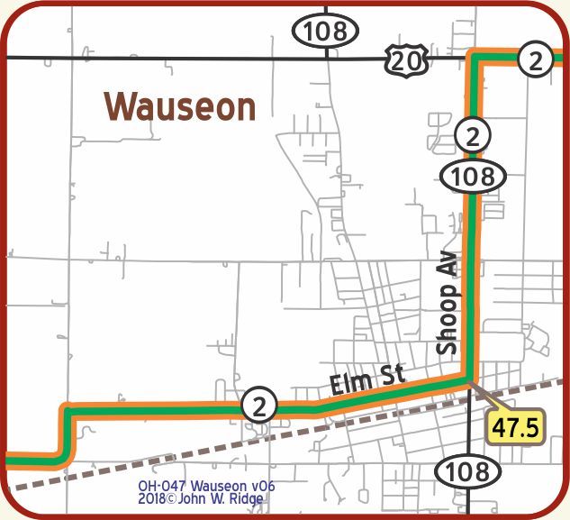
OH-047.5 Wauseon
 229 Monroe St. Fulton County Historical Society. Displays include mastodons, tales of lives of Native Americans, the lives of frontier pioneers, Underground Railroad abolitionists, and soldiers from many military conflicts.
Depot St. The Lake Shore and Michigan Southern (LS&MS)Railroad Depot. Depot St. is between Fulton and Brunell Sts. This 1896 Depot is on the National Register of Historic Places. Currently Amtrak still passes the depot each day. The depot houses artifacts relevant to the history of the eight railroads that once traversed the county, and a large “O” gauge model train display.
S Fulton and Chestnut Sts. Fulton County Courthouse. On the National Register of Historic Places. Opened in 1872 and is still in use today.
OH-081.00 Toledo 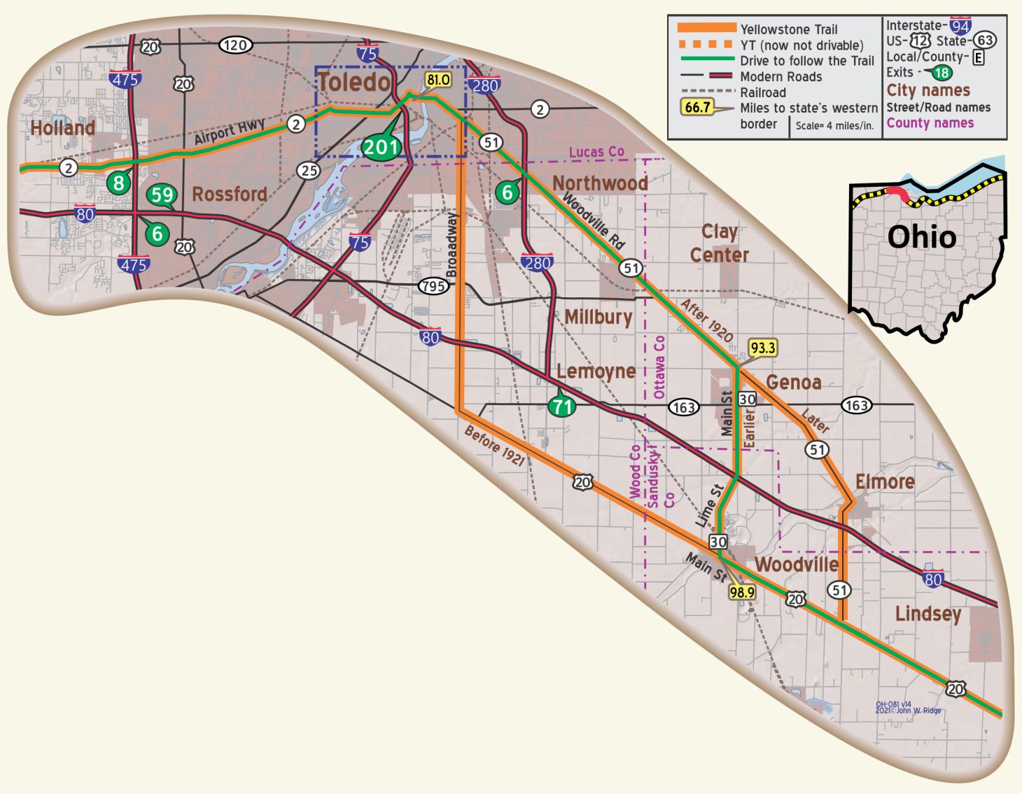 Toledo is interesting historically. The river drive leads past Fort Meigs on the Maumee rapids, which was held by the Americans under Harrison against the British in 1813. Also on the river are Fort Miamis and Turkey Fort, which played an important part in the early development of this country. In later days Toledo was the center of operations in the so-called Ohio-Michigan war over the line of division between the two states. BB-1920v4*
Toledo possesses natural gas and is noted for its varied manufactured products. It is also a great market for lime, plaster and cement. It is the home of the Overland and Ohio electric automobiles and is one of the greatest automobile distributing centers. The art museum, one of the finest buildings of its kind in any American city, is a source of particular pride to the citizens of Toledo. BB-1920v4*
Toledo has been called “Glass City” ever since Edward Drummond Libbey came to town in 1888 and brought his New England Glass Works with him. Later, joining with glassmaker Michael Owens, the company of Libbey-Owens Glass became the leading glass company in the U.S. There were other glass companies, such as the Toledo Mirror and Glass Company, so the city lived up to its name. Even today it is commonly so called.
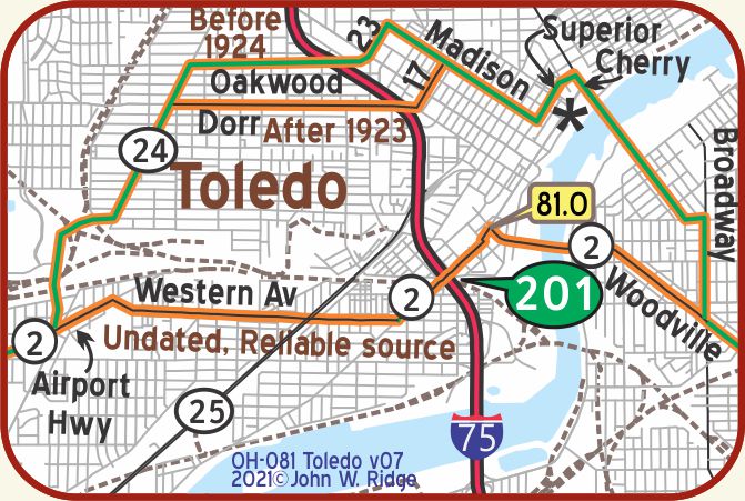
The Toledo of today would hardly be recognized by Yellowstone Trail travelers of 100 years ago. Downtown Toledo has mostly financial institutions and small restaurants.
We saw few, if any, shops, unless they were hidden on the ground floors of skyscrapers.
Mobile food stands provided lunch for the more budget-conscious office worker.
Three hotels of the Yellowstone Trail era are still in business.
While they were not on the Trail, we include them here because of their historicity and because they were available to Trail travelers as described in Blue Books of 1920 and 1925:
The Waldorf Hotel corner of Summit & Madison with the facade of lower floors covered nicely (this is now an apartment complex).
Hotel Monticello (now called the Davis Building) is well kept at Jefferson Ave. & Michigan St., houses miscellaneous agencies and businesses.
Hotel Lorraine (now called Lorraine Motor Hotel) offers low cost housing at Jefferson Ave. and 12th (closed).
2445 Monroe St. The Toledo Museum of Art was founded by Edward Drummond Libbey who collected art works and opened the first museum in rented rooms in 1901. In 1912 Libbey moved the museum to its present location in the imposing columned building with the wonderful, wide entry steps. Today there are 30,000 pieces in 6 buildings on 36 acres with many programs that invite participation. Returning to its roots, the museum has added a Museum of Art Glass Pavilion.
2001 Collingwood Blvd. Toledo History Museum. Located in the historic Milmine-Stewart House, 1874, the museum offers a glimpse into Toledo’s rich and diverse past.
Lime was first produced in 1872 in Woodville and still today there are at least three lime plants near Woodville. They call themselves the “Lime Center of the World.”
107 E Main St. Woodville Historical Museum. Contains a collection of local historical items.
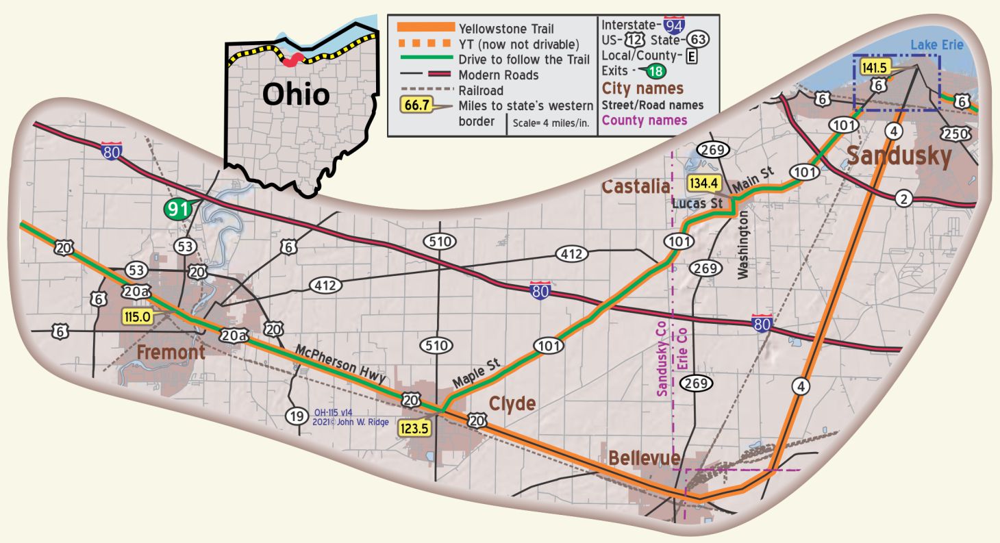
OH-115.0 Fremont
(pop. 12,500, alt. 630 ft.) abounds in historic memories from its earliest days. A British post was established here during the Revolution and, during the war of 1812, the one successful land battle on American soil was fought at this point. This is known as the battle of Ft. Stephenson. BB-1920 v4*
Fremont was the home of Rutherford B. Hayes, thrice governor of Ohio and president of the United States. His remains lie at rest in beautiful Oakwood Cemetery near this city. At the south edge of town in a beautifully wooded park stands his old home, known as Spiegel Grove, now the residence of Col. Webb C. Hayes, who has recently deeded it to the Ohio archaeological and historical society for use as a state park. In the grove is a handsome Hayes memorial library and museum building, erected by the state and formally opened in 1916. It contains the priceless 10,000 volume library of Americana gathered by President Hayes, as well as military, historic and personal souvenirs. This building is open to the public every week day afternoon. BB-1920v4*
1337 Hayes Ave. Spiegle Grove. President Rutherford B. Hayes Presidential Center. Entrance to the Hayes Center is at the corner of Hayes and Buckland avenues. (GPS: 41.34187, -83.12666). Of the eight presidents associated with Ohio, two (Hayes and Garfield) lived near the Yellowstone Trail.
The facility consists of two buildings – the Hayes Home and Hayes Museum. The museum houses Hayes’ personal belongings as well as documents from all U.S. Presidents. The Hayes grave site is nearby. The Library consists of 100,000 volumes of American history. He was president 1877-1881.
514 Birchard Ave. Sandusky County Historical Society Museum. A Victorian home built in 1884 houses artifacts of local interest. Rutherford B. Hayes was one of the Society founders.
OH-123.2 Clyde
124 W Buckeye St. Clyde Museum. The museum is in a white-steepled former church. The Clyde Museum features unique historical items such as Indian artifacts, pioneer to industrial era items, and stories of famous people from the Clyde area.
198 E Maple St. home and museum of General James McPherson, hero of the Civil War. (cor. of US 20 “McPherson Highway”/Yellowstone Trail, and Ohio 101). A National Register of Historic Places Property & Ohio Historical Society Marker Location. It is small with a small sign on a busy corner so it could easily be missed.
222 W McPherson Hwy. (Yellowstone Trail). Route 20 Diner. A few years ago this diner was called the Yellowstone Trail Diner.
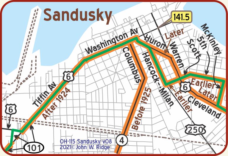
OH-141.4 Sandusky
(pop. 19,989, alt. 629 ft.) lies on the shore of Sandusky bay, the best harbor on the great lakes, large, landlocked [sic] and 18 miles long. This city commands a fine view of the harbor. The older portion of the city was laid out in rectangles with large reservations for park spaces and public buildings. A few hundred yards back from the lake is a public square on which fronting the lake are the principal churches and public buildings. The first Methodist Epicopal church west of the Allegheny mountains is still standing here. It is interesting to note that this church was built by an appropriation from Congress. BB-1920v4*
Sandusky is the most convenient point of departure for the islands of Lake Erie, among them Put-In-Bay, the scene of Perry’s victory, in honor of which a huge monument was recently erected. On the eastern of the two peninsulas which inclose the bay is Cedar Point, the “Atlantic City of the west.” It is the largest summer resort on the great lakes, and can be reached by boat or automobile. BB-1920v4*
1 Cedar Point Dr. Cedar Point is still there on the eastern peninsula, only now it is the “roller coaster capital of the world” on 364 acres of amusement park, hotels and restaurants. What would Yellowstone Trail era travelers think now!
404 Wayne St. Follett House Museum. Corner of Adams and Wayne Sts. Each of the four floors of the 1827 mansion tells the history of Sandusky. There are documents from “Prison Island” and the Civil War. It is on the National Register of Historic Places, and is in a neighborhood of great old houses.
1415 Columbus Ave. Cooke-Dorn House State Museum, built 1844. Sandusky is known for its collection of limestone buildings including this Greek Revival.
107 Columbus Ave. Sandusky State Historic Theatre. The Sandusky State Theatre has been in operation since 1928 functioning as a top Vaudeville theatre, movie palace, and world-class performing arts center. In 1992, the Theatre underwent a major renovation and has since become Erie County’s largest not-for-profit arts organization featuring live performing arts. It is on the National Registry of Historical Places.
403 E Adams St. The Rush R. Sloane House was a famous stop on the Underground Railroad during and before the Civil War. The house is not open to the public but just driving by might stir your interest in U.S. history. Read more here.
The Yellowstone Trail ran close to Lake Erie. Thus, travelers on the Trail had many opportunities to view the lake. We can only surmise that travelers stopped at whatever marinas and lighthouses were there 100 years ago. That lake-hugging route along Lakes Erie and Ontario was popular among trail organizations – so popular, in fact, that the Yellowstone Trail Association was not permitted to put up its signs along the lakes in New York until after 1918 because of the plethora of 11other trail “colors” that were present.
WAYSIDE – Ohio Blue Hole. From the 1920s to 1992 a favorite stop for travelers was the mysterious Blue Hole, just one half mile north of Castalia on the banks of Cold Creek. It was a road side attraction that kids looked forward to, having been bored to death by miles of flat Ohio corn rows. The Hole was mysterious and beautiful; a 75-foot pool of crystal clear water bubbled up from an aquifer of unknown depth. The Castalia Trout Club was formed to manage the property; they added bridges, paths, a water wheel, and water aeration for the added trout. However, its fame paled and another Blue Hole was opened an additional one half mile north. This one was owned by the state of Ohio which utilized the wonderfully clear water as a fish hatchery. The same source of water from that aquifer, now-known to be 60 feet down, feeds this newer Blue Hole which entertains a new generation of kids who find magic in fish idling by in deep, clear water. Read more here.
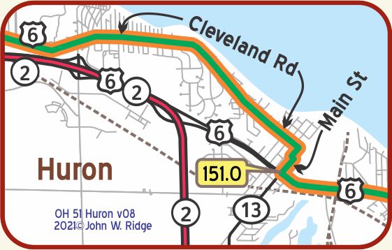
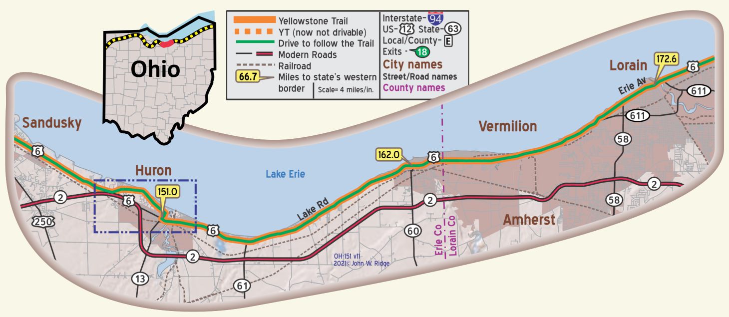 OH-151.0 Huron
(599 alt., 1,820 pop.), at the mouth of the Huron River, has a natural harbor that made communications with the interior of Ohio comparatively easy a century ago. When the completion of the Huron-Milan canal diverted shipping and building to Milan, the town’s propelling force was lost. Decades passed before fishing, and later coal and iron ore transshipping, and finally the tourist business restored Huron to some semblance of its former self. WPA-OH*
The Huron Lighthouse (visitors not allowed beyond the cement pier), opposite the end of N. Main St., was built in 1934 to supersede the lighthouse erected in 1847, which stands near by. It has an outer white light of 7,500 candlepower, visible for 17 miles. WPA-OH*
 The highway continues to follow the lake shore. Between Vermilion-on-the-Lake and Huron, a succession of resorts, tourist camps, dance halls, amusement parks, and institutional camps attract thousands of vacationists each summer. Hundreds of cottages dot the low wooded shore along miles of sandy beaches. WPA-OH*
A word that the traveler will see on signs and hear is “Firelands.” Here is the term’s origin: Erie County had its origin in the Revolutionary War. Connecticut towns were burned in the historic raids of Benedict Arnold and British General Tyron; 500,000 acres of Ohio were awarded by the Connecticut Assembly in 1792 for compensation to the fire-sufferers. Those acres are now Huron and Erie Counties. This area is therefore known as “The Firelands.”
333 Williams St. The Huron Historical Society Museum is located on the lower level of the Huron Public Library. There are exhibits about Huron and its waterfront history.
Main St. at the harbor. Huron Harbor Pierhead Lighthouse. A lighthouse was first placed at this point in 1847. Then in 1936 a new lighthouse was built using the “art-deco” style. Directions: From US 6 follow Williams St. north to the lake. It will end at Wall St. Turn right onto Wall St. and follow that for a short distance to Main St. Turn left onto Main St., and follow that to the end where there is a small parking area. You can now walk out to the lighthouse on the pier, but the last part is difficult -somewhat rocky. Although the lighthouse that the Trail travelers would have seen is not there, the view is the same. There is also a white pyramid lighthouse at the harbor.
120 Ohio St. (at Lake Park) Christ Episcopal Church built in 1839. On the Register of Historic Places.
NOTE: Just northwest of OH-151.5 in Huron, the intersection of Main St. and Cleveland Rd. was rebuilt and relocated so following Williams St. for a very short distance is probably necessary.
OH-162.0 Vermilion
(604 alt., 1,605 pop). Like many other towns along Lake Erie, Vermilion is both a fishing center and a tourist resort. Somnolent in winter, the town comes to life with the first touch of spring; all manner of boats come out of hiding, and the fields are webbed with great stretches of nets drying and undergoing repairs. Tourists are passing through the town in large numbers. An annual regatta is held here in August which attracts boating enthusiasts from the various lake ports. WPA-OH*
Liberty Ave. (US 6, Yellowstone Trail). The downtown area is Harbour Town, an 1837 Historic District and the center of the community. It features old buildings repurposed as restaurants, shops, marinas, and more. Community-wide revitalization efforts have encouraged property owners to retain the unique charm of their businesses and homes.
13115 W Lake Rd. (US 6, Yellowstone Trail) 1.5 miles west of Vermilion. Lakeland Lodges. Although their website does not state the history of the place, we believe that it saw Yellowstone Trail travelers because a reviewer said that it “looked the same today as it did on a 1926 postcard.”
Also, their website encourages the reader to “step back in time to when life was simple …” and describes “cozy cottages and bonfires on the beach,” certainly reminiscent of Yellowstone Trail days.
Two buildings of special note probably seen by Yellowstone Trail travelers are:
1.) 5581 Liberty Ave. Old Vermilion Banking Company Building. Built 1907 in early 20th century Beaux Arts style. Seems to be a newly refurbished wine bar.
2.)5780 Liberty Ave. Old Pelton Home. Built about 1820 by Capt. Josiah Pelton. Was once called Old Shore Inn. Not well maintained. A private dwelling.
There are 41 buildings on the National Register of Historic Places in Vermilion. Ten of them are homes of ship captains, which is not surprising because of Vermilion’s connection with shipping on Lake Erie. Fourteen buildings are on or near the Yellowstone Trail.
51211 N Ridge Rd. Benjamin Bacon House Museum and Carriage Barn.
Go about five miles south of Vermilion on Vermilion Rd. to Ridge Rd. Benjamin Bacon House Museum and Carriage Barn 1845 at Mill Hollow in Vermilion River Reservation. Bacon was an early settler. The museum features themes of daily living and includes the profound effect the railroad had on the economy and on people’s lives.
OH-172.7 Lorain
(pop. 50,000, alt. 610), lies at the mouth of the Black River. Though comparatively new, it is an important point for shipbuilding, as for over 3 miles the stream exceeds 200 feet in width, with an average depth of 15 feet. It is now the fourth port on the lakes in receipt of ore and an important point for shipbuilding and steel making. BB1920v4*
Annual production of sandstone in Lorain County alone totals approximately 700,000 cubic feet. In a landscaped ravine on Milan Ave. back of the town hall is Old Spring Park, with outdoor tables and benches made from large grindstones. WPA-OH*
309 W 5th St. Black River Historical Society’s Moore House Museum. It was the home of Mayor Moore and family in the 1920s. It has been restored to reflect life at that time period in the City of Lorain.
617 Broadway. Palace Civic Center. Rebuilt in 1928 after the 1924 tornado and called the Palace Theater, it featured silent films, vaudeville acts, the great Wurlitzer organ and more every evening. Gothic on the outside, opulent Italian Renaissance inside, sculptures everywhere. Apparently money was no object for Warner Bros., the owner. In 1977 the declining theater was purchased by the city, and after Herculean fund raising efforts, it emerged as the successful Palace Civic Center. It is worth taking a look, and Yellowstone Trail travelers may have.
The symbol many people have come to identify with Lorain is the 1917 Lorain Lighthouse, or the “Jewel of the Port.” The lighthouse stands at the north end of the West Harbor Breakwater in Lorain Harbor. One must take a boat to tour the lighthouse. A museum and tour ticket office are located at 138 Alabama Ave. To get there, take US 6 (Erie Ave. and Yellowstone Trail) to the east end of the bridge over the Black River and then turn north from US 6 onto Alabama Ave.
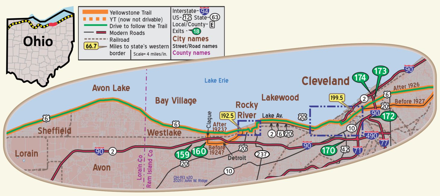
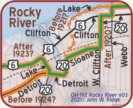
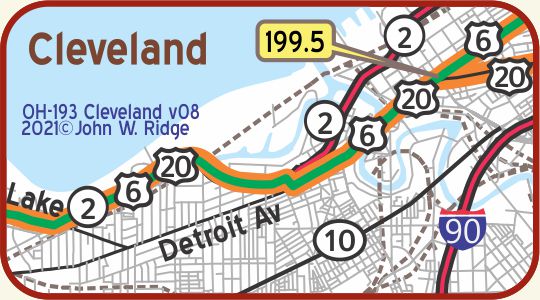
OH-199.5 Cleveland
West of Cleveland, US 20 (Yellowstone Trail) leads through a prosperous residential district. WPA-OH*
Cleveland (pop. 880,000, alt. 580 ft.) At the southeast corner of the public square, Euclid avenue, one of the most famous streets of America, begins. This street was once renowned for its private residences, but is now the principal retail thorofare of the city. Four miles out on Euclid avenue, beyond East 107th street, is University circle, which intersects the Cleveland park system and is a beautiful spot for a moment’s rest. BB-1920v4*
“Road conditions from Cleveland to Buffalo are not so good, but travel is never seriously inconvenienced. When roads are bad, cars are shipped by boat at a small expense.” Yellowstone Trail Association 1919 Route Folder.
 1501 Euclid Ave. (Yellowstone Trail). Playhouse Square, 5 theaters, 10 production spaces located in downtown Cleveland, is the “world’s largest theater restoration project.” Abstracted from their website: “These theaters, built in 1920-21 for vaudeville and movies, were ultimately impacted by the rise of television and population flight to suburbia and by 1969 all but one were boarded up.” Then a 20-year grass-roots effort restored them, one to its original 1920s elegance.
Euclid Ave & E 12th St. Hotel Statler, now Statler Arms. It is still a hotel with a nice lobby.
6709 Euclid Ave. Dunham Tavern Museum. Once a stagecoach stop on the Buffalo-Cleveland-Detroit post road, Dunham Tavern Museum today is the oldest building still standing on its original site in the city of Cleveland. The 1824 home of Rufus and Jane Pratt Dunham is now a designated Cleveland Landmark and is listed on the National Register of Historic Places. In stark contrast to the cityscape that surrounds it, the museum and its gardens offer a glimpse of history and insight into the lifestyles of early Ohio settlers and travelers.
19000 Lake St. foot of 1910 Detroit Ave. Bridge over Rocky River Gorge. The Westlake Hotel. The hotel opened its doors in 1925, at a cost of $3.5 million. Interurban lines, then busses, stopped just across the street for a direct trip to downtown Cleveland. After years of ups and downs in fortune and a half-million dollar fire, the site became renewed as a nice-looking 98-unit condominium complex. [Note: The entrance lobby is beautiful – full of plants.]
3900 Wildlife Way. Metroparks Zoo. By 1910, Cleveland’s Metroparks Zoo had started building exhibits where animals could roam freely outside of cages. In 2012, it opened the $25 million African Elephant Crossing, the zoo’s two-story indoor Rain Forest. Visitors will find many more animals from Asia, Africa and the Americas than did Yellowstone Trail travelers 100 years ago.
Lakefront Reservation is made up of three very distinct properties, Edgewater Park, Gordon Park and E 55th St. Marina on the shores of Lake Erie, together called the “Emerald Necklace.” The Emerald Necklace Centennial, 100th anniversary, was in 2017. In 1917, Yellowstone Trail travelers, no doubt, visited these parks, dipping a toe into Lake Erie to cool from long hours in non-air conditioned, dusty Model Ts.
Lorain Ave. and W 25th. West Side Market, established in 1912 and still going strong over 100 years later! Cleveland’s oldest public market is home to 100 vendors offering all manner of foods.
10825 East Blvd. Western Reserve Historical Society
History Center. Five miles east of downtown take US 6, Superior Ave. (Yellowstone Trail). Just across Doan Brook, turn south on to East Blvd. The museum has the state’s largest collection of regional history. It also includes the Crawford Auto-Aviation Museum with 200 rare autos and planes. And a restored 1910 carousel.
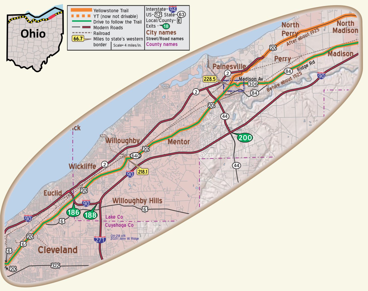 OH-218.1 Willoughby
(649 alt.,4,363 pop.), Originally called Chagrin, Willoughby was named for an instructor in the Willoughby Medical College. The school grew rapidly after its establishment in 1834 and had nearly 200 students when, in 1843, a Mrs. Tarbell discovered that her newly buried husband was not where he should have been—in his grave. The onus of blame for Mr. Tarbell’s unseemly disappearance fell on the school. Virtually the whole town rudely invaded the college building, turned the rooms upside down searching for Tarbell’s vagrant remains, bashed in furniture, and tossed fragments of cadavers through the windows. Evil days fell upon the college because of this episode, and in 1847 it closed its doors. Four teachers went to Cleveland to establish what later became the Western Reserve University medical school; others moved to Columbus and founded the Starling Medical School, now part of Ohio State University. WPA-OH*
The 19th century downtown district is on the National Register of Historic Places. As the downtown deteriorated, the residents saw an opportunity to reinvent the downtown, coupling historic preservation with a commercial center.
Today the old buildings house new, thriving businesses.
30 Public Square (on US 20, Euclid Ave.,Yellowstone Trail). Willoughby-Eastlake Public Library and History Center. No museum, but research materials are available.
25 Public Square. Indian Museum of Lake County Technical Center – Bldg B Corner of River St. and Center St. near US 20 (Yellowstone Trail). Visitors can see prehistoric items, 10,000 B.C. to 1650 A.D. locally or statewide, also Native American crafts, 1800-2012.
2 Public Square. The Willoughby Area Welcome Center is open year round in the historic Barnes House, adjacent to the Willoughby City Hall. This 104 year old “Cobblestone Cottage” provides information about the historic aspects of Willoughby and Lake County and other visitor services.
OH-221.9 Mentor
8095 Mentor Ave. President James A. Garfield National Historic Site (Lawnfield). The home of the 20th President (inaugurated March 1881, assassinated in July, died in September) features his private study, library, memorabilia and many original furnishings. The visitors center, in the carriage house, contains permanent exhibits of Garfield’s life and career.
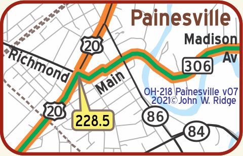 OH-228.5 Painesville
(702 alt.,12,237 pop.) A fixed character discernible today in the prim elegance of its old houses, the Western Reserve’s architect-builder, Jonathan Goldsmith, lived here 36 years in the 1800s. Painesville has several examples of Goldsmith’s work. WPA-OH*
Five of architect Goldsmith’s 1800s designs still standing today are:
1.) 106 E Washington St. The Gillette House, built of red brick, has long round-arched windows, two of which have tiny iron balconies, a Classic-columned side porch, and corbeled chimneys.
2.) 792 Mentor Ave. (Yellowstone Trail). The Rider Tavern, once a stop on the Cleveland-Buffalo stage route, was built in 1812. It is patterned after Washington’s Mount Vernon home. A two-story portico with square columns gives the tavern a stately beauty. This place on the Yellowstone Trail is still in business today as a Bed and Breakfast. It is known for its historically significant stop on the Underground Railroad. Of course, it is on the National Register of Historic Places.
3.) 391 West Washington St. Lake Erie College. A school for women was established in 1857. The school is patterned after Mount Holyoke College and has six buildings occupying a 40-acre campus. “Its varied program and individualized instruction carry out the ideal of its founders in furnishing to young ladies … a thorough education.” The grounds are still beautiful.
4.) 470 Railroad St. Railroad Depot. Built in 1893 by the Lake Shore & Michigan Southern Railroad, the building was considered the jewel of Painesville. In 1914, it became part of the New York Central, and in 1971 the last passenger train pulled out of the Painesville yard. In 1997, depot owner Edward Dunlap donated it to the Western Reserve Railroad Association for restoration.
5.) 415 Riverside Dr. (Ohio 84) Lake County Historical Society Museum. It houses the only collection of 1900s music boxes in the state of Ohio. A collection of these “Magical Musical Machines” demonstrates home entertainment from the turn of the century and vary in size from one foot to several feet. The museum also contains displays of trolleys, a Civil War wing and an historic Ohio frontier village.
348 Mentor Ave. Steele Mansion Inn. This 1867 mansion is a short walk from Lake Erie College in a “genteel” neighborhood. Now a small hotel and “Gathering Hub,” the large home has been returned to its original looks. After the Steele family occupied it, the home became part of the College, then an apartment house. Walk in and enjoy the restored old carved trim and the authentic appointments along with modern accouterments.
The Painesville City Hall, northwest corner of the public square, was designed by George Mugate, and this Classic Revival style edifice was completed in 1852.
The Mentor Ave. Historic District is bound by Liberty St. (east), Washington St. (south), Mentor Ave. (north) and terminating at the intersection of Washington & Mentor near Lake Erie College. This district, which includes 54 buildings, is significant both architecturally and historically.
OH-243.1 Unionville
UNIONVILLE (305 pop.), old and history-laden in the Western Reserve. At the northwest corner of the town’s crossroads is the New England House (tavern), an imposing three-story structure, first opened in 1805 as an inn. Here paused soldiers on their way to battle in the War of 1812; stagecoaches made overnight stops, and Negro slaves rested in their flight to Canada. During the 1830s and 1840s, when bog iron was mined in the vicinity, ironmongers and sailors rattled the 14-inch beams with their jollities. Old records and curios are on display. WPA-OH*
Ohio 84 and County Line Rd. (Yellowstone Trail). The UnionvilleTavern, described above, still stands as Unionville Tavern although it is popularly known as The Old Tavern. Beginning as two log cabins in 1798, this historic tavern was the first tavern in Ohio. It served as an inn before becoming known simply as the “Old Tavern.” By the mid-nineteenth century Unionville Tavern was an active Underground Railroad Station. There is still a tunnel under the building through which escaped slaves may have traveled. It served as a functioning inn until the early 20th century and a restaurant thereafter. In 2011 the Unionville Tavern Preservation Society was created with hopes of returning the decaying Tavern to its former historical status. During 2019 it was undergoing serious renovation, but stop by anyway. Explore www.savethetavern.org to see great pictures of the renovation process of this historic tavern. Unfortunately, due to COVID-19, all work on the building has been suspended until further notice.
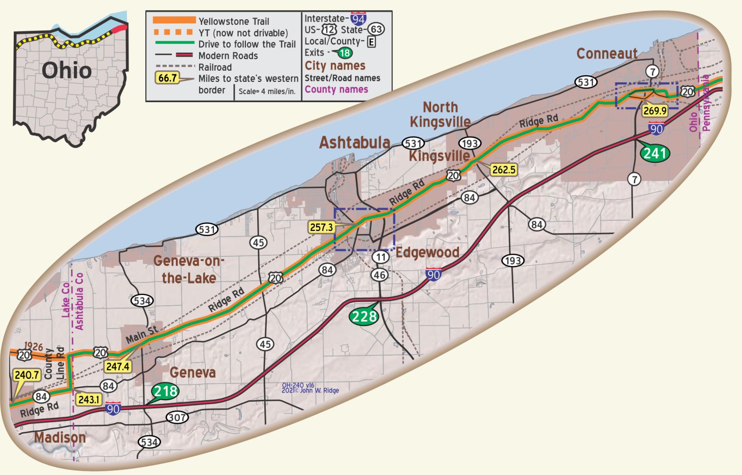
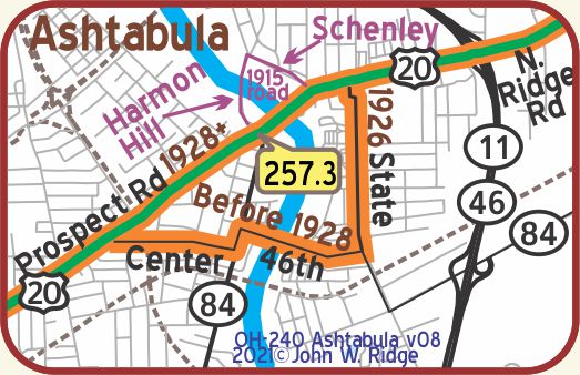 OH-257.2 Ashtabula
In 1831 it was incorporated, and carried on as a fishing and farm trading center. Strong abolitionist sentiment made it a key terminus on the Underground Railroad. On December 21, 1850, the Ashtabula Sentinel reflected the temper of the town on the slavery issue:
“Resolved, That we will not aid in catching the fugitive but will feed and protect him … and that we pledge our sympathy and property for the relief of any persons in our midst who may suffer any penalties for an honorable opposition or failure to comply with the requirements of said law.” WPA-OH*
The segment of the Yellowstone Trail from Cleveland, Ohio to Erie, Pennsylvania runs through a dairy and fruit country. The road is all concrete or brick, except two short stretches of macadam. 1926 Mixer’s Route Guide and Strip Maps.
The Yellowstone Trail Association had trouble with Ashtabula’s covered bridges in developing the Trail. It took several routes over the years.
Ashtabula has a strong maritime, abolitionist, and lake shore recreation history. It also promotes an amazing 18 covered bridges in the area. Locations of the bridges may be obtained by going to www.coveredbridgefestival.org.
1603 Walnut Blvd. Hubbard House. Built in 1841, the two-story brick house sits on the shores of Lake Erie. It served as a terminus for the Underground Railroad that carried escaped slaves across the lake to Canada. Today, the house is a museum dedicated to the region’s role in the abolitionist movement.
1071 Walnut Blvd. the Ashtabula Maritime Museum. Built in 1871 and located atop a cliff overlooking Ashtabula harbor, the museum is the former home of the Ashtabula lighthouse keeper and Coast Guard chief. The museum’s seven rooms house thousands of photographs and artifacts that tell the story of Lake Erie and Great Lakes shipping – the good and the tragic.
4726 Main Ave. Hotel Ashtabula. Built in 1920, it now no longer functions as a hotel. Once the “pride of Ashtabula, new, fireproof, and modern. Offering excellent food and room rates from $2.00 up” according to Mixer’s 1926 Route Guide and Strip Maps. The hotel ceased in 1965 but the restaurant ran until 1985. The building stood empty until 2014 when it was completely overhauled. On the National Register of Historic Places. Go look inside and see if any traces of the1920s remain.
West 5th St. from its 1200 block to the Ashtabula River. Ashtabula Harbor Commercial District. West 5th St. has also been known as Bridge St. because there is a bridge over the Ashtabula River at the end of it. The Ashtabula Harbor Commercial District is an historic district in the northern section of the city including 75 properties and buildings constructed largely between 1865 and 1878.
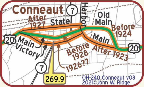 OH-269.9 Conneaut
CONNEAUT (ko’-ne-ot) (650 alt.,9,357 pop.), is at the mouth of Conneaut Creek. Its name is an Indian word variously interpreted to mean ‘fish,’ or ‘snow place,’ or it may be a corruption of gunniate, which means ‘it is a long time since they have gone.’ WPA-OH*
The natural harbor, around which Conneaut’s livelihood still centers, early attracted shipping of all kinds, causing the village to grow rapidly. Millions of tons of coal and ore are transshipped yearly from its docks, the coal to the upper Great Lakes, the ore to the steel mills in eastern Ohio and Pennsylvania. WPA-OH*
363 Depot St. Conneaut Railroad Museum. The railroad museum is housed in the old passenger depot (1900) of the New York Central railroad. The tracks are still in use. You will see trains, historical photos, a NYC video, and more.
230-238 State St. (US 20, the Yellowstone Trail). The Cleveland Hotel (c.1914), now Cleveland Hotel Luxury Apartments is on the Register of Historic Places. Writer Sharon Wick describes the renovated hotel today thus: “The Hotel has been brought back to its splendor and reminds us of the days when it was in its glory … you are delightfully surprised to see the original mosaic flooring, the original ceilings and the original fireplace. There are 3 full floors above ground and the lower level of the hotel that all have been made into 28 condos …”
246, 250, and 256 Main St. (Yellowstone Trail). Harwood Block, built in 1889, housed an opera house on its third floor until 1903. This was a major stop for touring companies between Buffalo and Cleveland. The third floor was then leased to the National Guard for drills, and after World War I became a dance hall. The stage is still intact. Several merchants now occupy the first floor.
“The historic architecture leads to the high Victorian Italianate mode. The cast-iron storefront was produced in Chicago and shipped to Conneaut on the Nickel Plate Railroad. With no instructions for its installation, Main Street was roped off and pieces assembled on the street, then attached to the building.” Gail Diehl, News-Herald, July 20, 1978.
501 Sandusky St. Conneaut Area Historical Society. There are many displays that speak of the area’s history as well as a research library.