
 The map’s green circle markers
are modern highway exit numbers
used for current location reference.
 The map’s yellow rectangle mile markers show path of YT and distance to state’s west border. Click the corresponding number in text for directions and more information.
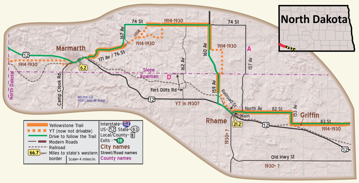 For Directions, click the North Dakota State (ND-) YTA Mile Marker Numbers below linking you to a real-time map.
ND-000.0 Montana/N. Dakota Line
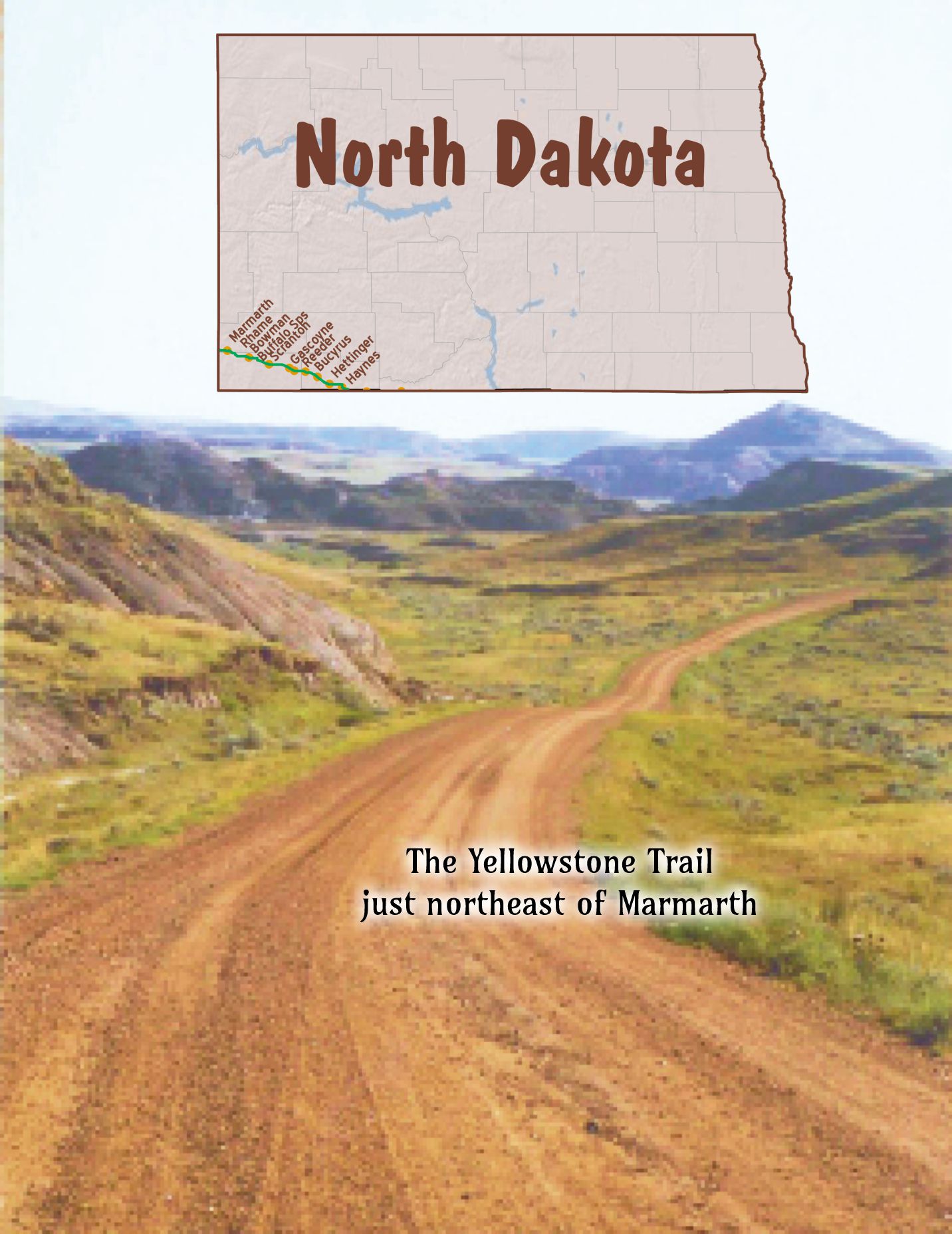
ND-006.2 Marmarth
(pop. 1,500, alt. 1,800 ft.), is a modern little city located in the most picturesque part of the famous Little Missouri river badlands. A drive of about six miles north of town takes one to the foot of Pretty butte, one of the most fantastic badland formations. There are extensive camping grounds in Marmarth. BB1921-9*
As the tourist nears Marmarth the Badlands of North Dakota are reached, these being one of the most curious natural formations; very interesting and picturesque. WPA-ND*
Marmarth is at the confluence of Little Beaver Creek, Hay Creek, and the Little Missouri River. Known as the “city of trees,” Marmarth is almost an oasis in the treeless Badlands country. The town had its inception in 1902, and grew rapidly following the advent of the Milwaukee R. R. in 1907. Proximity to the Little Missouri and its tributaries has not always been advantageous; the town has been flooded five times. Dikes have been put up around the town adjacent to the streams. WPA-ND*
Marmarth is a shipping point for cattle brought overland from range grounds in this State, Montana, and South Dakota. The stockyards, which cover an area of 45 acres, and contain 86 pens and 15 loading chutes, are built on the site of the old O-X (0 Bar X) ranch. Nearby, on Hay Creek, still stands the squat old ranch house in which Theodore Roosevelt was once a guest. WPA-ND*
It is a freight division of the C. M. & St. Paul R. R. Cozy Cafe is well liked. Marmarth Camp, 50c, wood stoves; a nice site on river.
ST. CHARLES HOTEL is best; 30 rooms, 6 with r. w., 3 with bath; sgl. $l-$2; dbl. $1.50-$2.50; with bath $3.
PHILIPS MOTOR CO., Ford, owner is master mechanic. Fine for all cars. Labor $1.50; phone 42 until 10 p. m. MH-1928*.
In 1911 Marmarth was the largest city in North Dakota on the Milwaukee Road. By 1917 it was the only town in North Dakota to have natural gas piped in for both commercial and domestic use.
The problem of crossing the Little Missouri River at Marmarth yielded many a story including the fording of the river in 1913 by Michael Dowling and the fund-raising efforts of the Yellowstone Trail Association. For the stories and pictures of the crossing, see Trail Tale: Marmarth Bridge, page <?>.
After a long period of stagnation, Marmarth, just south of the Little Missouri National Grassland, seems to be enjoying a renaissance of sorts.
The Bismarck Tribune says,
Population is 136 as of the 2010 census, but that doesn’t take into account the folks who drive through on Highway 12, the oil workers who drift into town and the paleontology scholars and volunteers who participate in summer dinosaur projects.
305 First St. W (US 12/Yellowstone Trail). Unique Antique Auto Museum. The Unique Antique Car Museum showcases its 50 refurbished antique vehicles, a miniature car collection and a vast collection of old license plates from1916, and a 1920s die cast toy collection.
51 Main St. The Mystic Theatre was built in 1914, and is now owned by the Marmarth Historical Society. It has a stuccoed exterior and seats 187 (another source says 109 seats). It was unusual for its time, as it was specifically designed for showing “motion pictures” 13 years before “talkies” happened. It opened April 22, 1914, and was packed.
It is listed on the National Registry of Historic Places. The Society still operates the theatre and hosts a cowboy poetry gathering in September of every year, along with local talent and visiting entertainers. In 2014 there was a big 100th birthday bash for the edifice.
118 N Main St. Pastime Bar (one block north of US 12/Yellowstone Trail) or, more formally, Pastime Club and Steak House. Don’t be scared off by the name. It’s just a cowboy bar that serves great food and has creative participatory entertainment. We ate there a few years ago and had the best, largest hamburgers we ever ate.
WAYSIDE – Marmarth Research Foundation in the Hell Creek Formation near Marmarth. Dr. Tyler Lyson of the Smithsonian has been digging for dinosaur bones and fossils in this Badlands area his entire life. His 501(c)(3) Foundation has attracted other professional university paleontologists. It is entirely private, but amateurs are invited to dig, for a fee, and careful attention is made to maintain scientific integrity. The site includes tents, a lecture hall/dining facility and a lab. There is an office in Marmarth.
ND-021.2 Rhame
(3,184 alt., 356 pop.), named for M. D. Rhame, district engineer of the Milwaukee R. R. when it was established in 1907, has the highest elevation of any town in the State. It is in a high valley between two large, flat, scoria-capped buttes. WPA-ND*
A 1924 Bulletin lists the Buttes Hotel and the Yellowstone Trail Garage.
Rhame’s first post office (1908) was a derailed boxcar. Before this, the mail was brought by stage and placed under the rock ledges of Post Office Butte for people to pick up their mail. The townsfolk celebrated their 100th anniversary in 2008.
SE corner of Main & 2nd Sts. is a log cabin built in 1912 as a whimsical-style gas station. It was most recently used as a community museum. The walls were made of logs from a camp at Ekalaka where they were assembled before moving to Rhame. The roof is covered with scoria rock and extended on the west side so as to cover the service area. Note the height of the trees in that area in this picture. No car has approached the building in many decades (see picture below).
As you travel east from Rhame you will notice less of a “badlands” scene, fewer volcano-like buttes and more rolling hills and cattle. You might even see a few oil pumps.
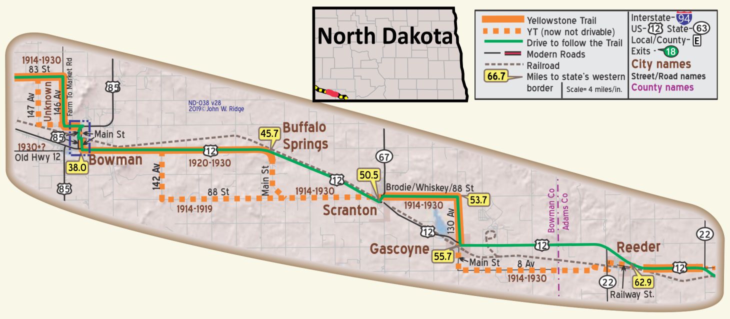 ND-038.0 Bowman
A live town in a grain and cattle raising area. Meals at Rudolph Hotel. Bowman Motor Co. is modern Ford Agency. Free camp site, no shade. Good new pay camp to be built.
RUDOLPH HOTEL is partly modern; 3 rooms with bath, dbl. $2.75; dbl. without r. w. $1.75. MH-1928*.
A 1924 Bulletin lists two more garages.
12 First Ave. NE. The Pioneer Trails Regional Museum is a regional research and repository museum reaching from within 100 miles of Bowman to include parts of Montana and South Dakota. As such, it has programs available on anthropology, archaeology, paleontology, botany, and others. Part of their mission is to conserve local historical artifacts and fossils. [Note: Western South Dakota and Western North Dakota are prime areas for organized dinosaur digging.] Guided tours of fossil sites are available as well as “hands on” digging. It is a sharp, energetic museum with a broad vision, a sod house, and a good book selection in its small shop. We stop in whenever we are in the area to view changing displays and their list of scientific guest speakers. Step into their small back yard and you will see a Yellowstone Trail sign.
If you are in Bowman in early September, you might see their annual Threshing Bee and display of 100-year-old farm equipment such as the huge Reeves Steam Tractor. Actual threshing happens and you can volunteer to experience what farming was like in Yellowstone Trail days.
WAYSIDE – About 30 miles north of Bowman is an oddity of nature. The Burning Coal Vein is a badlands landscape still in the making. For at least 200 years and until very recently a fire was smoldering in the coal layer several feet underground. As the burning turned the soil above it to ash, it collapsed, leaving large cracks in the surface of the badlands. The phenomenon still occurs on occasion, but the U.S. Forest Service has a policy of mechanically extinguishing the coal veins where they’re burning on the Little Missouri National Grasslands in order to prevent grass fires. A visitor might still see escaping gasses and slumping soil.
ND-045.7 Buffalo Springs
(2,850 alt., 75 pop.), was known briefly as Ingomar, but in 1907 received its present name, suggested by the nearby springs which once served as a watering place for the bison that roamed the plains. WPA-ND*
Gas, supplies and repair shop. Small free camp. MH-1928*
ND-050.5 Scranton
pop. 450; in a grain district; has several active coal mines. Scranton Garage is best; open until 10 p. m. ALBION HOTEL not modern, but clean rooms; dbl. $1.50; water and bath in halls. Good meals 50c MH-1928*
Named in 1907 for Scranton, Pennsylvania, because both were coal mining towns. Clay suitable for brick manufacture was discovered and today’s Yellowstone Trail traveler may see remnants of 1907 brick work on downtown buildings. Briquetting lignite coal was a big operation.
Many grain elevators today suggest a major grain shipping center.
ND-055.7 Gascoyne
(2,759 alt., 97 pop.), Northwest of town is a railroad Reservoir (swimming and picnicking facilities). WPA-ND*
pop. 90. Gas and small garage. MH-1928*
Pause as you travel the Trail. Look at Gascoyne, population 12. They have erected a small memorial to the Trail. It is a limestone hoodoo, found easily in these parts, painted yellow with a new Yellowstone Trail sign attached, flanked by two flags. Not bad for a very small village!
The name of the town in 1907 was Fischbein, a hamlet founder, but was changed to Gascoyne, a railroad foreman, in 1909 because “Fischbein” was too difficult for Morse Code spelling.
ND-062.9 Reeder
A typical farm center. Oelker’s Hotel is best; not modern. Free camp with stoves and tables. OELKER’S GARAGE, Ford, and good on all cars. MH-1928*
Reeder had a population if 181 in the 2000 census. It, like many other towns, got its name from a Milwaukee Road railroad employee. A strain of wheat has been named after the town.
Reeder citizens have repurposed their old school, which they say has retained its integrity from the first graduating class, 1916, to the last, 1993. It has retained the gym for physical workouts and transformed 12 rooms into motel-type rooms for hunting parties, wedding parties and any other overnight groups. Space is also available for quilting retreats, auction sales, etc. And what does this do for today’s Yellowstone Trail traveler? You could stop in, shoot some pool, exercise a little and see what’s cookin’. Quite a creative idea for a small town to stay vibrant. It includes the Dakota Prairie Enrichment Center, a 501(c)(3) organization.
Just to the west of Bowman 83 St. and 146 Ave. were, together, named “Farm to Market Rd.” a general name given to early regional roads.
The 1921 ND maps seem to indicate that the main route (and thus the YT) followed 147 Ave., now not usable.
It is no longer possible to travel between 6th St. and the railroad on the Main St. route of the YT. So just south of the railroad, use 1st St. between Main St. and 1st Ave.
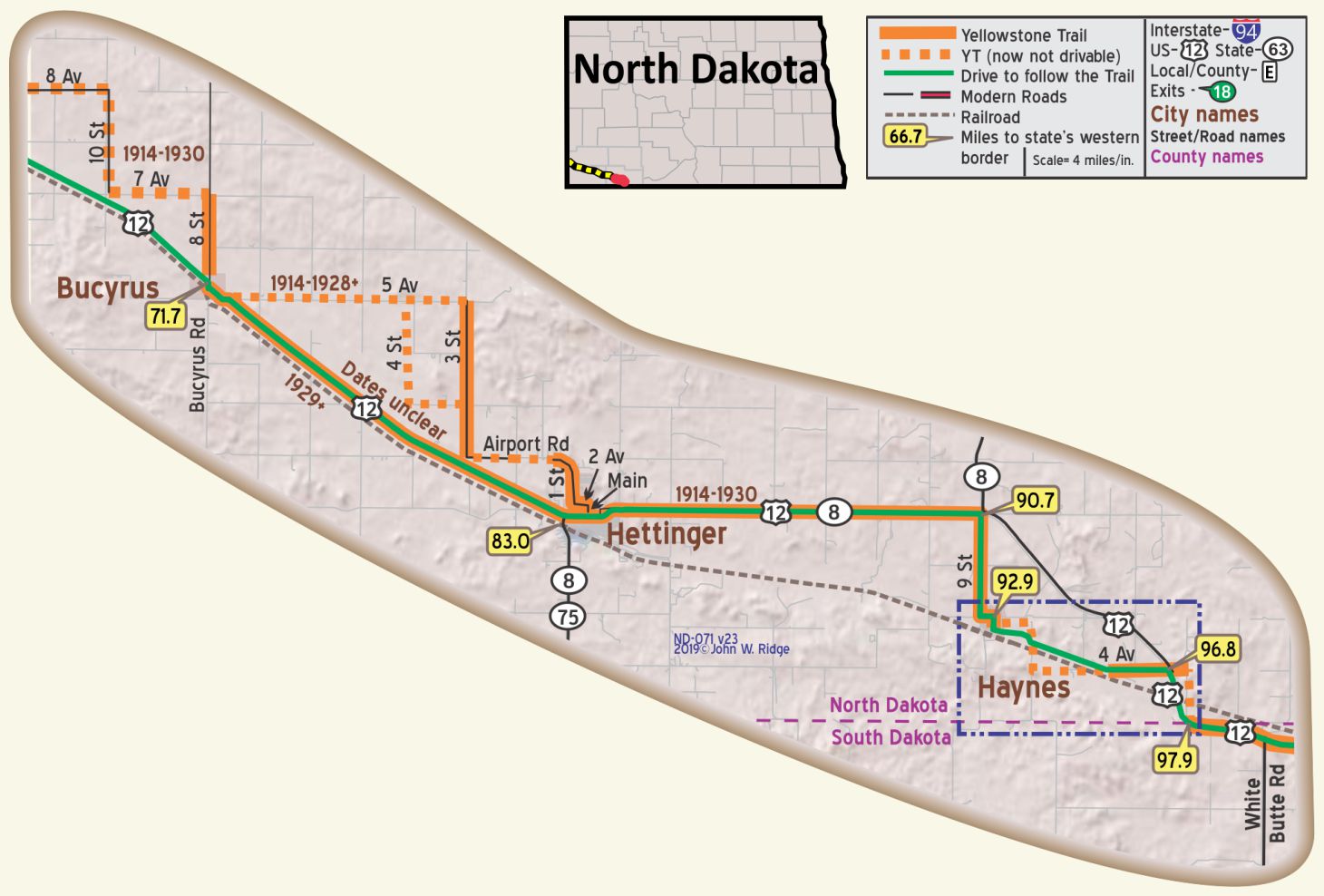 ND-071.7 Bucyrus
Bucyrus was first known as Dolan, in honor of the contractor for the Milwaukee Road Railway grading. During the grading for the tracks a new name was sought for the town, and Bucyrus, the trade name of one of the huge steam shovels in use, was suggested. Bucyrus once had a Yellowstone Trail Garage.
NOTE: The Bucyrus steam shovel and other large, early road building equipment were manufactured in another Yellowstone Trail town, South Milwaukee, Wisconsin.
The population of Bucyrus was 27 in the 2010 census. The town was struck by a wind-fueled wildfire on October 18, 2012. Thankfully two dozen residents of Bucyrus were evacuated before the fire and there were no injuries. However, much of Bucyrus was lost in the fire.
ND-083.0 Hettinger
(pop. 1,000, alt. 2,400 ft.). There are a great many interesting rock formations in this section worthy of note. On the north side of town are some high buttes capped with rock containing fossils of imprints of leaves, as perfect in outline as the day they were deposited there. There is a lake at the edge of town where a swim may be enjoyed. BB1921-9*
THE YELLOWSTONE HOTEL steam heat and r. w. in all rooms; sgl. $1.50-$2; dbl. $2; 3 rooms with bath $3
NOTE: There was also a Yellowstone Garage listed in 1924.
THOMPSON AUTO CO. is best for heavy cars; skilled men and modern bldg. Labor $1; ph. 17 until 10:30.
HETTINGER AUTO CO., Ford; large and modern. Ph. 24 until 10 p. m. MH-1928*
At Hettinger, one can get from the rocks on the buttes numerous beautiful imprints of leaves, also some fossils. On the side of the road east of Hettinger lie several petrified stumps. Sections of petrified trees can be found in abundance in this neighborhood.
As in the Yellowstone Trail days, the scenery here still offers the traveler broad plateaus, majestic buttes, rolling prairie and wide, windswept vistas. This book encourages the reader to experience the Yellowstone Trail as much as possible. Appreciating scenery is part of that experience.
During the years that the YT passed through and near Haynes before the routing of modern US 12, the local roads were crude and ill-marked. Maps produced by national companies had little definitive information about the alignment of the YT which apparently was defined by which roads were driveable that week. Most of the sources we located show the use of approximately the routes shown on the map.
In 2013 Hettinger folks were instrumental in getting state representatives to officially recognize the whole of US 12 in North Dakota (100 miles) as a “Memorable Highway in the State of North Dakota” The route is now marked with Yellowstone Trail signs. In the fall of 2016 the Adams County Record featured five articles which traced in depth the emergence of the Yellowstone Trail through Adams County and Hettinger “in an effort to increase awareness of this historical roadway.”
400 11th St. S. Dakota Buttes Museum is a complex of four redesigned buildings and outdoor exhibits displaying more than a century of life and times in Adams County. While you are there, look at the Yellowstone Trail kiosk and ask about Mr. O. T. Peterson and Rev. George Kenniston, two very early officers of the Trail Association. Also, ask about the self-guided tour brochure called Buffalo Trails in the Dakota Buttes which takes in 10 historic buffalo sites as well as current buffalo ranches.
ND-092.9 Haynes
Nearing the status of a ghost town, Haynes is a pleasant place to explore a bit and see a well maintained Yellowstone Trail hoodoo marker in the center of town (below). A “hoodoo” is a wind-formed obelisk of sandstone. The community keeps it painted yellow.