
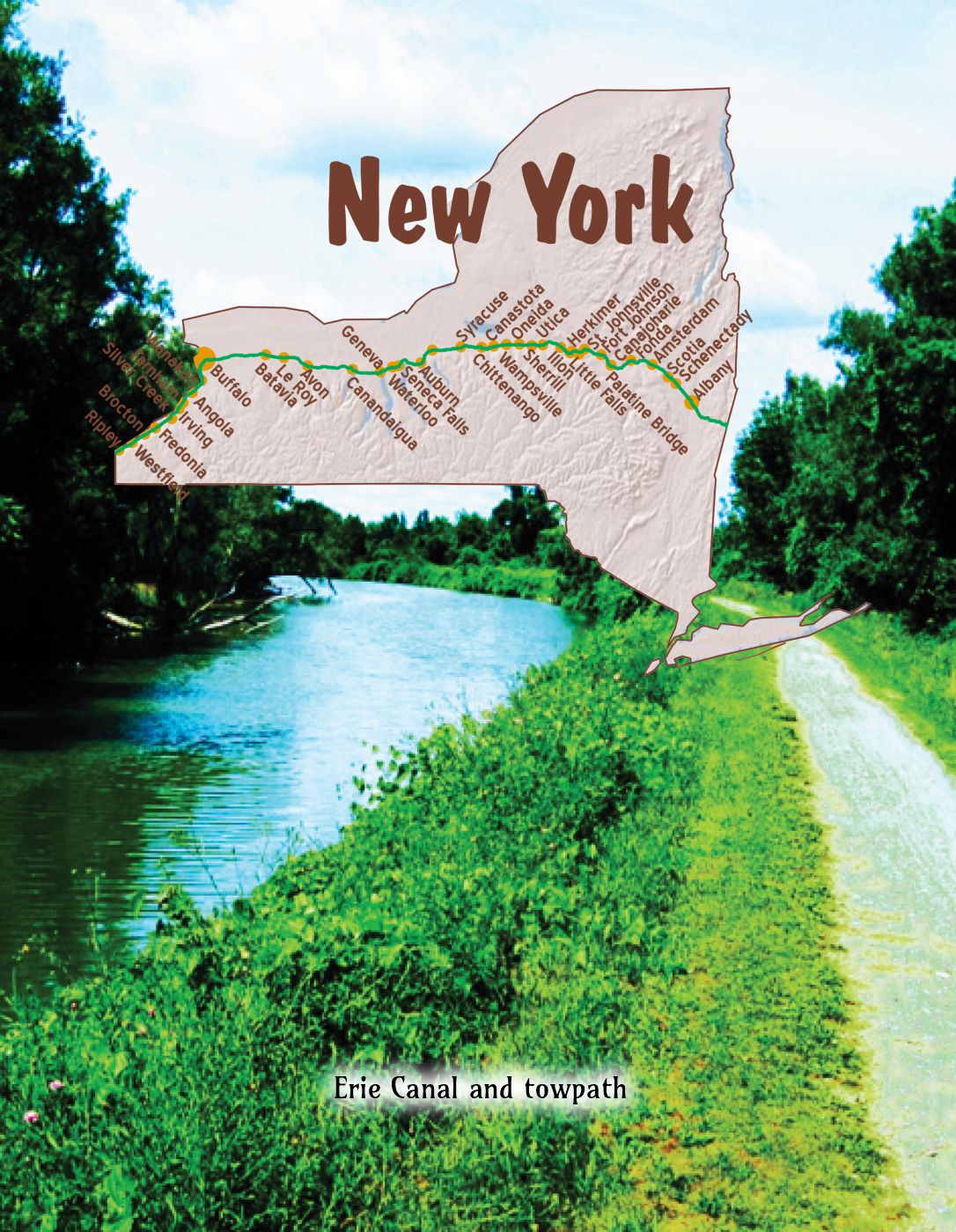
 The map’s green circle markers
are modern highway exit numbers
used for current location reference.
 The map’s yellow rectangle mile markers show path of YT and distance to state’s west border. Click the corresponding number in text for directions and more information.
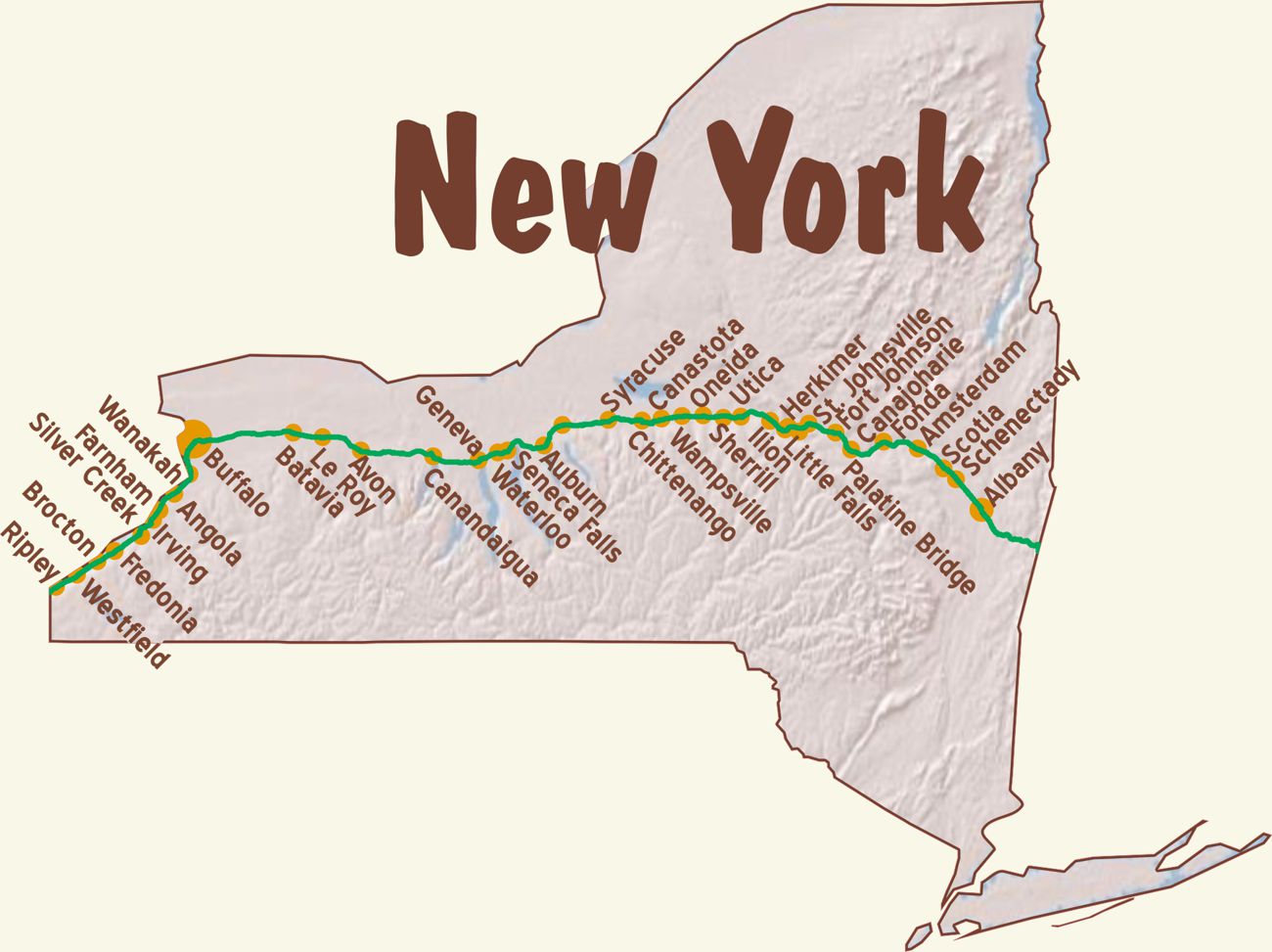
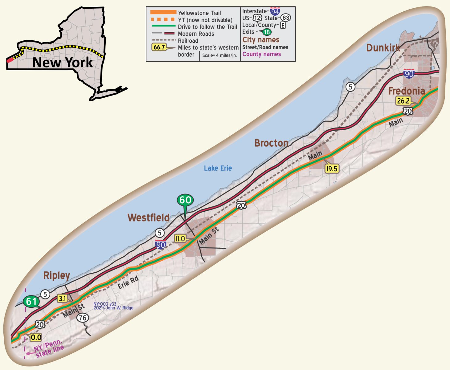 For Directions, click the New York YTA Mile Marker Numbers (below) linking you to a real-time map.
NY-003.1 Ripley
Ripley was for a long time the State’s busiest hasty marriage site. Rival justices had large signs in front of their homes, neon-lighted at night and open for business 24 hours of the day: out-of-State couples could take their pick. But since the passage of the Todd ‘anti-hasty’ marriage law, requiring three days to elapse between the license and the wedding, the marrying business has evaporated. WPA-NY*
At the time the Yellowstone Trail was routed through Ripley, its economy was built around grape-growing. Much of the recent economy of the town is based on growing fruit, especially Concord grapes.
10759 W Main St. (Yellowstone Trail/US 20). Kelly Hotel. This 1824 hotel had survived through thick and thin – through life as a stagecoach stop, through two visits from Abe Lincoln, through Prohibition and through the Great Depression. Unfortunately, it has not survived any longer and is up for sale at this writing. What will the seven reported ghosts do now?
NY-011.0 Westfield
(pop. 7,980, alt. 750 ft.), lies in the heart of the famous Chautauqua grape belt and is the home of Welch’s grape juice factory. The Chautauqua grape belt comprises a two to three-mile strip running about 30 miles east and west of the town, and a drive thru the beautifully kept vineyards during the early summer or late fall is well worth while. In the town, on West Portage St., may be seen the principal office of the Holland Land Co., of which Wm. H. Seward, Lincoln’s secretary of state, was the head. Opposite it is the old colonial home of the Sewards. Northwest of the village, about 10 miles on the old Portage road, is the quaint little fishing hamlet of Barcelona. This at one time was the Lake Erie port of entry and better known than Buffalo. The old lighthouse which still stands here was the first building in the state of New York to be lighted by natural gas. BB1921-1*
The present main WELCH PLANT (open), N. Portage St., erected in 1910, produces 3,000,000 gallons yearly and employs about 500 men and women. Other local industries include the grape juice division of Armour & Company and auxiliary shops manufacturing grape baskets. WPA-NY*
Many grape vineyards are seen along the Yellowstone Trail from the Pennsylvania state line to Westfield. Chautauqua County is the largest grape growing county outside of California. There are several winery tours and tastings available. Road Trip USA called Westfield the “Grape Juice Capital of the World.” Resident Dr. Charles Welch introduced the product to the world in late 19th century and the rest is history. Today the headquarters for Welch Foods are still in Westfield.
40 E Main St. (NY 20 and Yellowstone Trail) Westfield Main Diner. Westfield and Brocton were hotbeds of diner manufacturing in the 1920s. The original lunch car portion of the diner (a 1926 Ward and Dickinson) has lunch counter seating and a kitchen area. An additional room was built on in 1983. This is the closest operating diner to Silver Creek, factory site of Ward and Dickinson diners in the 1920s.
20 E Main St. Chautauqua County Historical Society and McClurg Mansion Museum. The mansion was built in 1818 by pioneer James McClurg and contains period furniture, artifacts, and farm machinery. “Its grand salons and formal rooms stood in sharp contrast to the rugged homes of neighboring frontier settlers,” says their brochure.
East Main Street Historic District is a national historic district encompassing 20 buildings and the Westfield Cemetery located along East Main St., the Yellowstone Trail. Within the East Main Street Historic District stand mid-nineteenth to early twentieth century residences.
E Main St. and South Portage. French Portage Road Historic District is a national historic district. It encompasses the nearly intact 19th century and early 20th century village core of 104 buildings.
~♦♦♦♦♦~
WAYSIDE – 10 Roberts Ave. Chautauqua Visitors Center. About 11 miles south of Westfield on NY 394 is the town of Chautauqua on Chatauqua Lake. The Chatauqua Institution was founded there as a summer school for Methodist Sunday School teachers and quickly expanded into a national speaker and entertainment bureau in late 19th and early 20th centuries. Wholesome topics and musical performances were the order of the day and, with no movies or television, the arrival of a Chautauqua presenter in a small, rural town in the West was a very popular event. Yellowstone Trail Association Field Representative and fund raiser, Rev. George Keniston, was a popular Chatauqua speaker and an ordained minister c. 1914.
Chautauqua Institution. Today, for nine weeks each year, from late June through late August, the Chautauqua Institution offers an extraordinary blend of arts, lectures, opera, symphony, dance programs, and recreational activities. One can rent one of the many Victorian cottages and attend events or lounge around Chatauqua Lake. An Athenium Hotel is also on the grounds, dating from the mid 1800s.
Lucille Ball-Desi Arnaz Museum and Center for Comedy. Keep driving south about 19 miles farther on NY 394, then NY 474, then NY 60 to Jamestown and the Lucille Ball-Desi Arnaz Museum and Center at 2 W 3rd St. You are correct. They had nothing to do with the Yellowstone Trail, but the guide at Chatauqua told us that they were as much “Americana” as the Chatauqua lecturers and entertainers.
Costumes, memorabilia, and awards are only some of the things on display.
Also, see the Lucille Ball Memorial Park in Celoron, NY, just minutes to the west. A new statue of Lucy replaces the 2009 one, considered by most to have been “scarey, looking totally unlike Lucy and hated.”
~♦♦♦♦♦~
NY-019.4 Brocton
(740 alt.,1,301 pop.), celebrates the memory of Deacon Elijah Fay by holding a grape harvest festival each autumn, with pageants, street fairs, and dances. Deacon Fay began experimenting with grape culture around 1811, trying several varieties that failed, but was finally successful with the Isabella and Catawba, and later with Concord, which has since become the favorite of the region. WPA-NY*
Jct. of Main St. (NY 20/ Yellowstone Trail) with Lake and Highland Aves. Brocton Arch, a double arch over the street, placed on the National Register of Historic Places in 1996. Brocton Arch is an historic “welcome arch.” It is a 1913 freestanding steel arch over a public thoroughfare bearing the community’s name. It is a rare double span, four-way street arch.
41 W Main St. Green Arch Restaurant is a 1931 Mulholland diner, another long-standing reminder of the glory days of diners.
2 W Main St. St. Stephen’s Hotel. According to Wikipedia,
The St. Stephen’s Hotel has been a fixture at the center of Brocton since the mid-1800s. It was bought and sold several times… Recently (2012) local resident Al Seavy has bought it and has begun to return the St. Stephen’s Hotel to its former glory.
WAYSIDE – Seven miles south of Brocton (take Co 380, then Co 58 east) is the tiny village of Lily Dale. Founded in the 1870s as a spiritualist mecca, it was very popular for those who rejected Darwinism and who “longed to believe in life after death and who wanted to contact the spirits of the dead,” says Mac Nelson, author and emeritus professor at State University of New York – Fredonia. There were summer programs of lectures and other activities featuring authors and leaders in research into psychic phenomena. In his fascinating book, Twenty West (State University of New York Press, Albany, 2008), Nelson says, “Spiritualism survives today as an entertainment and a small formal religion.” He reports that, “Even today, most of the residents are spirit mediums and if you are there on a Sunday, you might visit a service wherein a medium attempts to contact the dead.” Perhaps Yellowstone Trail travelers stopped by.
NY-026.2 Fredonia
(pop. 6,000, alt. 767 ft.), is in the heart of the “grape belt,” and often called the “Athens of Chautauqua” on account of its excellent schools. Here large quantities of nursery stock and grape juice are produced. It is the birthplace of the Woman’s Christian Temperance Union. This park, in the center of the village, was named for Gen. Lafayette, who visited here in 1826. BB1921-1*
[Families with] wealth from the grape belt have settled here, and their handsome homes do much to eclipse the grape juice and conserve plants, wineries, nurseries, and seed companies. Natural gas was discovered early in the nineteenth century and exploited almost immediately for lighting; the streets of the village are said to have been the first in the world to be lighted by gas. WPA-NY*
[Note: The site of the first gas well is marked by a stone monument downtown.]
The Fredonia Commons Historic District was listed on the National Register of Historic Places in 1978. The U.S. Post Office was listed in 1988. And we are still in wine country.
52 E Main St. (Main at White. NY 20/Yellowstone Trail) the White Inn Bed and Breakfast. The building was built in 1868 as a private home for the Devillo White family and opened on June 1, 1919 as an expanded public hotel. Several rooms on the upper floors are part of the original structure as is the foyer and University Room on the main floor. It still exudes charm and elegance in a stately, pillared, huge white home. It was recently renovated. Melanie Gambino, present owner, was most interested in the fact that the historic Yellowstone Trail ran right past the front door. [Closed as of 2020?]
280 Central Ave., State University of NY- Fredonia. SUNY Fredonia is a comprehensive, public, residential, liberal arts university located in beautiful Western New York. Founded in 1826, the university is among the oldest in the SUNY system.
9 Church St., Fredonia Opera House, two blocks from the Yellowstone Trail. Built in 1891, this premiere performing arts center has a year-round schedule of live events, concerts, films. Guided tours are available.
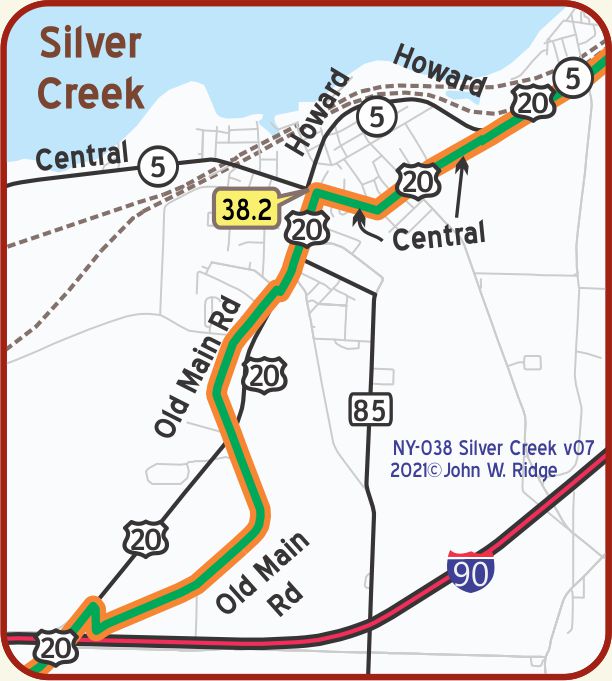
NY-035.2 Silver Creek
(pop. 3,500, alt. 726 ft.), situated on Lake Erie, is widely known for its manufacture of grain- cleaning and canning factory machinery distributed thruout the world. BB1921-1*
The grape belt here is five or six miles wide and extends to Harbor Creek, Pennsylvania, 55 miles away, comprising half of the grape acreage of the State, mostly Concord in variety. … but the big grape boom began in the early 1890s. Businessmen, professional men, and everyone who could shake loose a down payment bought farms and set out vines; production swelled to such a degree that it pushed the bottom out of the market, ruining many who had invested their last dollar. By 1900 the grape juice industry, founded by Dr. Thomas Branwell Welch, got under way and offered a new market for the grapes. Today annual shipments from Chautauqua County average about 5,000 carloads of grapes, and about one third again as many are used locally in making wine and unfermented grape juice. WPA-NY*
Silver Creek lies at the eastern end of Lake Erie and became an important shipping harbor before the advent of railroads. Today one can enjoy the recreational facilities and marina offered by the proximity to the lake.
From approximately 1907 to 1933 (roughly the Yellowstone Trail years) Silver Creek was on the Buffalo-to-Erie main line of the Buffalo & Erie Railway, a high-speed electric inter-
urban railway. It was abandoned by order of the New York Public Service Commission to promote highway transportation.
1277 Central Ave. (NY 5/ Yellowstone Trail) Dolly Dimples Waitress Statue. She’s about 12 feet tall and stands outside of Valvo’s Candy store. It classifies as roadside kitch that the Society for Commercial Archeology would be interested in.
Diners were built here by Ward & Dickinson from 1924 to the late 30s, but we can find no museum dedicated to diners or address of the manufacturing plant.
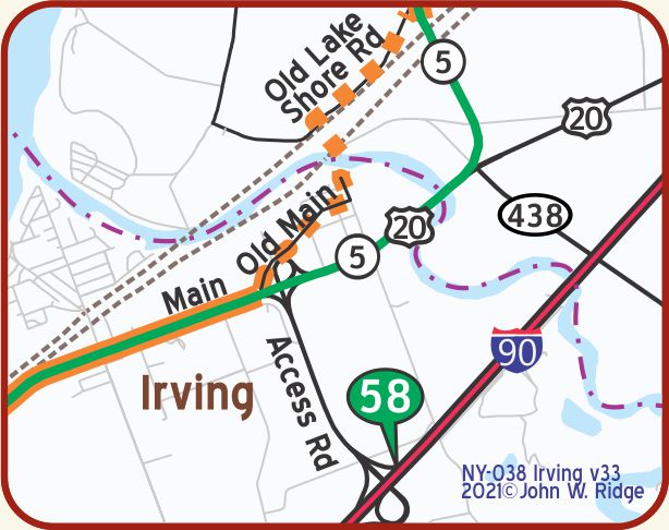
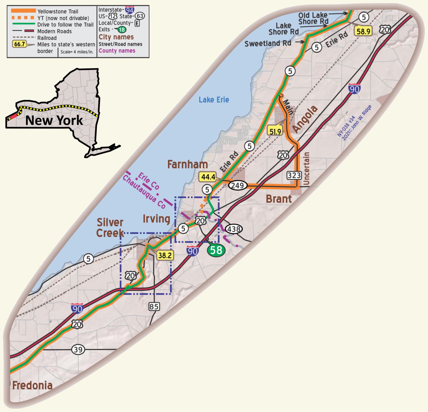
NY-044.4 Farnham
At Farnham the Yellowstone Trail trundled on straight east on what became modern NY 249 before turning north on what became modern NY 323 and joining what became NY 5. NY 5 was so numbered in 1924, just before the 1925-26 meetings of representatives of the federal government and states led to the Great Renumbering.
NY-051.9 Angola
8351 Erie Rd. (Yellowstone Trail). The Evans Historical Society and 1857 Museum.
NY-055.7 Derby
6472 Old Lake Shore Dr. (Yellowstone Trail). Frank Lloyd Wright’s Graycliff House. Graycliff Conservancy preserved and restored the home built for Isabell Martin between 1926 and 1931. It is high on a bluff overlooking Lake Erie with views of Canada. See also Wright’s Martin House Complex in Buffalo.
NOTE: Mileages after NY-061.8 are understated by 0.4 miles because of the late discovery that the YT followed Lake Shore and Old Lake Shore roads rather than NY 5, Erie Rd.
 NY-062.8 Wanakah
A village on the shore of Lake Erie. NY 5 (Lakeshore Dr./Yellowstone Trail) is the major east-west road which runs right through the village. The Township of Hamburg Park and Beach offers a stellar sand beach, swimming and boating opportunities. Yellowstone Trail travelers didn’t have those amenities 100 years ago, but they did have the lake in which to rinse off the dust of gravel and dirt roads.
WAYSIDE – Although the great Niagara Falls area was not noted as being on the Yellowstone Trail in their literature or the many maps of the Blue Book Company or other contemporary mapping companies, it would be foolish to think that Trail travelers would not take a short side trip to the Falls.
Rochester, however, was noted by the YT Association as being on the YT on some early material but the Batavia route, used in this book, emerged as both the de facto and then the official route.
 NY-074.5 Buffalo
Buffalo was laid-out in 1803-04 and became a military post in 1812. It extends along one side of the Niagara river, with Canada lying on the opposite shore, Along the entire length of this river were fought some of the fiercest battles of the war of 1812. Its rich historical sentiment, and the fact that at its northerly door are to be seen the world-famed falls of Niagara, has made Buffalo a mecca for the tourist. BB1921*
(pop. 506,775, alt. 630 ft.), combines manufacturing and commercial facilities with delightful residential conditions. Though generally regarded as an inland city, it is in reality one of the great ports of the world. Buffalo has gigantic industries, made possible by the great hydroelectric development at Niagara Falls. The immense iron and steel mills and outlying coal elevators are interesting commercial features of the city, which also lays claim to possessing the world’s greatest grain elevators. With the opening of navigation in 1918, Buffalo added to its already substantial transportation facilities one of the greatest artificial waterways in the world-the New York state barge canal. BB1921*
It has a preponderance of asphalt paved streets and improved state highways extend in all directions. Among the most noteworthy thorofares are Niagara street, Broadway, Main street, [the Yellowstone Trail in 1920, presently closed] Delaware Avenue… On the corner of Genesee Street and Delaware Avenue may be seen the castle-like residence of President Millard Fillmore.
At 1168 Delaware Avenue, near Ferry Street, on September 13, 1901, President William McKinley died of 2 gunshot wounds fired at him Sept. 6. On the same avenue, at number 641, near North Street, at the Wilcox house, Theodore Roosevelt was sworn in as President. BB1921*
There are about 30 museums in and immediately around Buffalo of interest to the traveling history buff. The following four were selected only because they were standing during the years that Yellowstone Trail travelers might have visited them. Check the web or an AAA Tour Book for the locations of others which might interest you.
263 Michigan Ave. Buffalo Transportation/Pierce Arrow Museum. The Pierce-Arrow Car Company is a symbol of one of Buffalo’s significant eras of growth and prosperity. This museum preserves the company’s long history.
1285 Elmwood Ave. Albright-Knox Art Gallery. Founded officially in 1862 as the Buffalo Fine Arts Academy. The Academy is the governing body of the Albright-Knox Art Gallery and is among the country’s oldest public arts institutions in the United States. Since its inception as The Buffalo Fine Arts Academy in 1862, the museum has been dedicated to acquiring, exhibiting, and preserving modern and contemporary art. Its present stately building opened in 1905.
1020 Humboldt Pkwy. Buffalo Museum of Science is a science museum located at Martin Luther King, Jr. Park in the northeast of the downtown district, near the Kensington Expressway (NY 33). The historic stately building was opened in 1929, a little late in the life of the Yellowstone Trail Association, but still available to Trail travelers. The excellent attractions include astronomy, the science of technology, and more about science.
1 Museum Ct. Buffalo History Museum. Housed in a stately 1901 building, its south portico meant to evoke the Parthenon in Athens. The museum serves to collect, research, interpret, and share the Niagara Frontier’s rich history. It annually presents a wide array of programs and activities for all ages.
143 Jewett Pkwy between Woodward Ave. and Summit. Frank Lloyd Wright’s Martin House Complex. Wright’s Prairie Style design applied to a large residence, consisting of six connected buildings containing a collection of art glass and furnishings all designed by Wright.
140 North St. at Delaware Ave. (Three blocks off the Yellowstone Trail). Hotel Lenox. The hotel opened its doors in 1896 as a luxury-suite hotel for the prominent and wealthy.
It was renovated in 2005, but kept its historic charm. It is advertised as the only hotel in Buffalo that has been in continuous operation since the late 1800s. It is a large hotel with its two large wings and recessed center looking quite imposing.
364 Pearl St. and labeled 2 Fountain Plaza. The Genesee Hotel/Hyatt Regency. The 1882 Genesee House was rebuilt as an office building in 1923, and became Hyatt Regency in 1983. Seemingly very sturdy for its description is thus: Renaissance-Revival building, steel frame, concrete slab floors, two floors of cast iron facade, and copper roof.
3165 Main St. (NY 5/Yellowstone Trail). Lake Effect Diner. According to their website, the Lake Effect Diner
is one of the last few dining car-style diners left in America. With old-fashioned milkshakes and a hearty menu of home favorites, Lake Effect has become a popular destination for locals and travelers.
262-274 Delaware Ave. Hotel Touraine. Erected in 1902, converted to apartments in 1982. Unique to Buffalo is this flamboyant Gothic Revival style with four-story annex (added 1923). The hotel originally had 250 rooms. One feature of the building was the installation of 100 bathrooms. Each room had a modern shower attachment. The tubs used were exhibited at the Pan-American Exposition and won a gold medal.
Lafayette Square (Washington, Clinton, Ellicott Sts.) Hotel Lafayette. The hotel opened in 1904 with two additions finished in 1917 and 1926 in a French renaissance style in red brick with trim of white terra cotta. It is now a boutique hotel and apartments with a smart black awning.
 NY-113.1 Batavia
(pop. 15,000, alt. 890 ft.) is known as a thriving commercial and industrial hub as well as an historic town. Batavia is another name for Holland, just as Britannia is another name for England. Perhaps the most historic landmark in western New York is the old Holland Purchase land office, located at Batavia, which has been preserved as a museum and which contains the greatest of revolutionary relics. The two old guns in the front of the building were cast in New York state arsenal which manufactured arms in 1812. BB1921-1*
131 West Main St. (Yellowstone Trail). Holland Land Office Museum. Built in 1804. Owned by the Holland Purchase Historical Society, the museum exhibits early farming tools, uniforms, and local records. The Holland Purchase included practically all of New York State west of the Genesee River, some 3,300,000 acres, sold in 1793 to a group of Dutch capitalists.
Joseph Ellicott surveyed it and was instrumental in the founding of scores of towns and villages, including Buffalo, but his pride was Batavia; “I intend to do all I can for Batavia because the Almighty will look for Buffalo.” WPA-NY*
NY-123.3 LeRoy
23 E Main St. (Yellowstone Trail). The Jell-O Gallery and Historic LeRoy House. LeRoy is the birthplace of Jell-O gelatin dessert, “America’s Most Famous Dessert.” It is at the rear of the Historic LeRoy House, an 1822 period house with three floors open to the public that interpret the house as it was used from 1830 to 1930. It contains a display of old transportation means – horse drawn sleds, carriages, an old Cadillac. The Gallery tells the story of Jell-O, from its rocky beginning in 1897 to today. “Jell-O advertising is a story of 100 years of American culture,” says Gallery director Lynne Beluscio. About 10,000 people visit the little Gallery every year. General Foods closed the Jell-O factory in 1964; Kraft Foods now manufactures Jell-O in Dover, Delaware.
 NY-130.2 Caledonia
3095 Main St. (Yellowstone Trail). Big Springs Historical Society Museum. Objects in the collection include those that represent the history of Caledonia’s Seth Green Fish Hatchery (the oldest in the northern hemisphere), military artifacts, and rare paper broadsides.
16 North St. Caledonia Fish Hatchery, 150 year old descendant of the Seth Green Hatchery, still using some of the original 1870s buildings, including the main hatchery, according to the New York State Conservationist, April, 2014. There is a small display, interesting especially to those who have never seen a hatchery before. Today the state fish hatchery specializes in brown trout. One can see various life stages of fish throughout the year. On the property there is also a small picnic area and historical information. We really liked this place. Bring quarters if you’d like to feed the fish.
NY-137.3 Avon
(583 alt.,2,337 pop.), is a farming and canning center with a considerable milk industry. The region is a horse-breeding area, and the annual Avon Horse Show draws a large gallery of spectators. WPA-NY*
Up to about 1860 Avon was a noted health resort. The United States Hotel and a dozen others were filled with guests who came to drink of the sulphur springs. Old registers carry the names of princes, dukes, and counts, Presidents and Senators. WPA-NY*
55 E Main St. (Yellowstone Trail). Avon Inn. Built in 1820 and listed on the National Register of Historic Places, this beautiful Greek Revival mansion carries on a century old tradition of dining and lodging. The 200-year-old house has 14 guest rooms, and is decorated in ante-bellum style, not in Colonial period. A few years ago we stepped inside but did not stay there. The 2018 renovation was stunning.
On NY 39, about 2 miles south of Avon at 2100 Avon-Geneseo Rd. the Avon Five Arch Bridge is a remnant of a railroad bridge over the Conesus Outlet at Littleville. It was added to the National Register of Historic Places in 2012. It was built 1856-57 by the Genesee Valley Railroad to span the Conesus Outlet. The 200 ft. long x 12 ft. wide limestone bridge was part of the Rochester – Avon – Geneseo – Mt. Morris line. The line was electrified in 1907 with 13 runs daily. In 1941 the Avon – Mt. Morris section was abandoned and the rails removed. Today the bridge is in very good condition.
283 E Main St. Tom Wahl’s Restaurant, a fun ‘50s place. Although not of the Yellowstone Trail era, this fast food restaurant apparently feels historic to the residents who list it right along with historic things to see in Avon. “It is not a fast food place,” insists the retired owner. “It is a place that sells good food fast.” We list it here because it is legendary to the residents and is on the Trail.
 NY-161.6 Canandaigua
After purchasing from Massachusetts all of New York State west of Geneva and extinguishing the Indian title to a large part of the tract, Phelps and Gorham appointed William Walker as their agent and he opened here the first office for land sales in America. The first party of settlers, led by General Israel Chapin, arrived in May 1789, and within two years the town was overrun with emigrants from New England moving west over the Great Western Turnpike and up the Mohawk Valley. Here the Ontario Female Seminary, organized in 1825, was a pioneer in the education of women. WPA-NY*
The ONTARIO COUNTY COURTHOUSE, top of the Main St. hill, is a two story gray brick Greek Revival structure built in 1858. Here was held in 1873 the trial of Susan B. Anthony and her associates, who had voted in a national election in Rochester. In 1937 women began jury service in this same courthouse where the pioneer suffragettes were found guilty of voting. WPA-NY*
US 20 and NY 5 rise gradually out of the flatlands to the westernmost Finger Lakes town of Canandaigua. Iroquois legend has it that the 11 narrow finger lakes were created by the hand of God. Five lakes bear the names of nations of the Iroquois Confederacy (Cayuga, Onondaga, Oneida, Seneca, and Tuscarora).
55 N Main St,. Ontario County Historical Society. Three exhibit galleries focusing on local history and a research library comprise this museum. Rotating exhibits spotlight life in various regions of New York. It is an elegant-looking building with tall, white columns.
295 N Main St. (Yellowstone Trail). The Gideon Granger Homestead and Carriage Museum 1814. Listen to stories of the four generations of Grangers who lived in this magnificent home from 1816-1930. Gideon was Post Master General under Jefferson and Madison. Over 50 horse-drawn vehicles are on display. Watch out, though. The arrow on Main St. is misleading. It shows an immediate left turn when it should show an arrow that points ahead for a block and then turn left.
151 Charlotte St. Sonnenberg Gardens and Mansion State Historic Park. Surrounded by 50 acres is a 40-room Queen Anne-style mansion built 1885-87 by Frederick Thompson, a New York City bank financier. Today, visitors can view many of its stately rooms of mixed architectural styles, and nine formal gardens.
Canandaigua Historic District, roughly Main St. (NY332/ Yellowstone Trail) from Chapin to Saltonstall Sts. encompassing Howell, Gibson, Gorham, Bristol, Bemis and Center Sts. GPS: 42.88611, -77.28019.
There is a nice city park along the lake front.
You are entering the Finger Lakes wine country. Just east of Canandaigua in the small town of Flint right on NY 5/Yellowstone Trail, is the Amberg Winery, a good introduction to this large wine-producing area before you.
 NY-177.7 Geneva
Among the foremost of the manufacturing establishments are the Geneva Cutlery Co., the largest razor factory in the world, the Standard Optical Co., United States Lens Co., and Fay & Bowen Engine Co. manufacturers of airplane and marine engines. Some of the largest fruit and ornamental nurseries are located here. Prof. William R. Brooks, a distinguished citizen of Geneva, has discovered more comets than any other man in the world. Geneva is an ideal stopping place for tourists, several pleasant drives into the surrounding country over improved roads radiating therefrom. BB1921*
The William Smith College for Women, adjoining Hobart College on the west, was founded in 1906 by Geneva’s philanthropist, William Smith, who, ironically, was a bachelor with little use for women. Smith students attend Hobart classes.
South Main Street Historic District has several buildings on the National Register of Historic Places. The street follows a long linear park, running along the shore of Seneca Lake. Although the Yellowstone Trail just skimmed the north tip of the lake, one could assume that the summer Trail travelers stopped for a quick frolic in the cool waters. GPS: 42.85774, -76.98176.
Cayuga-Seneca Canal, a New York Sate barge canal, connects Seneca Lake at its northern tip with the Erie Canal to the north east. It passes through Waterloo and Seneca Falls. It was approved by state voters in the early 20th century to compete with railroads.
NY-184.9 Waterloo
Several churches and homes on the National Register of Historic Places are on Main St. (US 20/ Yellowstone Trail) and Williams St. one block north.
31E Williams St. The Waterloo Library and Historical Society (WLHS). The Queen Anne Victorian style building opened in 1881. The Waterloo Library was constructed specifically as a library and has operated continuously as a library in its original building under its original charter. An annex to the Waterloo Library, Terwilliger Hall museum, displays photographs and maps from as early as 1806 which give a sense of what life was like in the village at the turn of the 19th century.
14 E. Williams St. The Mary Ann M’Clintock House is part of the Women’s Rights National Historical Park headquartered in neighboring Seneca Falls. On July 16, 1848, Mary Ann M’Clintock hosted a planning session for the First Women’s Rights Convention. At this session she, Elizabeth Cady Stanton, and several others drafted a document they called the Declaration of Sentiments. It was ratified on the second day of the First Women’s Rights Convention and signed by 100 men and women. Modeled on Thomas Jefferson’s Declaration of Independence, this document proclaimed that “all men and women are created equal.”
E Main St. National Memorial Day Museum tells the story of Memorial Day. Waterloo is the birthplace of that holiday.
Cayuga-Seneca Canal. The Seneca River, now the Cayuga- Seneca Canal, always has been an economic engine for the communities of Waterloo and Seneca Falls. The Seneca Lock Navigation Co., a private enterprise formed in 1813, dammed three sets of rapids and installed locks to allow goods to be transported to the Erie Canal. In 1818, a canal was opened between Cayuga and Seneca Lake. In 1825, a canal was begun to connect Seneca Lake with the newly constructed Erie Canal at Montezuma and the Cayuga-Seneca Canal was put into use in 1828. The Cayuga-Seneca Canal locks were modified in 1918 when New York State created the New York Barge Canal System.
 NY-188.6 Seneca Falls
In the WESLEYAN METHODIST EPISCOPAL CHURCH BUILDING, corner of Fall and Mynderse Sts., now an automobile showroom, was held in July, 1848 the first American woman suffrage convention, which, presided over by Henry B. Stanton, Mrs. [Elizabeth Cady] Stanton’s sympathetic husband, proclaimed that ‘women have the right-or ought to have the right-to vote and hold office. WPA-NY*
At the entrance to the Fall St. bridge is the SENECA FALLS HISTORICAL SOCIETY, which has several pieces of Mrs. Stanton’s furniture, including her rosewood piano. WPA-NY*
 Seneca Falls is on Seneca River, part of the Cayuga-Seneca Canal and three miles from the head of Cayuga Lake. The Cayuga-Seneca Canal connects to the Erie Canal and upstate New York’s Finger Lakes Region. The Cayuga-Seneca Canal is 12 miles long, built in c.1825 and combines the unique experience of inland water and deep-lake cruising.
The whole village is a buffet table for history buffs. Stand on the bridge over the Cayuga-Seneca Canal which once led to the Erie Canal. Seneca Falls was the model for the fictional Bedford Falls of the film “It’s a Wonderful Life” and many civic activities remind the visitor of that fact. The mid-1800s hub of action for the women’s suffrage movement was here. While the New England 1830s religious reform movement was going on just east of Seneca Falls, at the other end of the religious scale, one can visit agnostic Robert Ingersoll’s home in nearby Dresden. See Trail Tale: Freethinkers, page <?>.
136 Fall St. (Yellowstone Trail). Women’s Rights National Historical Park Visitor Center. Women’s Rights National Historical Park tells the story of the first Women’s Rights Convention held in Seneca Falls on July 19-20,1848. It is a story of struggles for civil rights, human rights, equality and global struggles that continue today. Be sure to see the absolutely astounding group of statues of the 1848 inspiring thinkers and their words within the Visitor Center. The park includes: Wesleyan Chapel, Elizabeth Cady Stanton House, Hunt House, and Visitor Center.
Wesleyan Chapel is where the action took place. When we first visited Wesleyan Chapel in 1999 it was a sorrowful shell with only holes for windows and not even four complete walls. It was a joy to see it restored completely by 2015.
32 Washington St. Elizabeth Cady Stanton House. Part of the National Women’s Rights Park. Stanton was instrumental in organizing the women’s suffrage convention.
On E Bayard St., near the Ovid St. Bridge, is a very life-like statue showing Amelia Bloomer introducing Elizabeth Cady Stanton to Susan B. Anthony. An historic chance meeting on the street.
89 Fall St. The Seneca Falls Heritage Area Visitor Center.The Heritage Area’s Visitor Center serves as an orientation point for local and regional history, providing a historical overview of the Reform Movements, specifically the Women’s Rights Movement, and the development of transportation and water powered industry. An interactive exhibit gallery gives visitors a look at life in historic Seneca Falls and area.
Seneca Museum of Waterways and Industry is located within the Heritage Area Visitor Center. The Museum illustrates how the Seneca River and the Cayuga-Seneca Canal powered the rise of industry and fostered cultural development, helping to spread social reform movements.
108 Fall St. The Gould Hotel, 1919. It was called The Clarence Hotel for awhile. The Movie “It’s a Wonderful Life” starring Jimmy Stewart and Clarence the Angel was shot in Seneca Falls, the town named Bedford Falls in the 1947 movie, which gets trotted out every Christmas. Revitalized in 2009 and again in 2018, the hotel now describes itself as a “modern boutique hotel and again a vibrant social center and premier destination.” We hope this last renovation retained the hotel’s unique historicity.
NY-A196.8 Cayuga (1920-1921 route of Yellowstone Trail)
The Cayuga Museum of History and Art. Shows the history of Cayuga, also featuring music, book clubs and movies. A jumping place.
Cayuga-Seneca Canal locks were modified in 1918 when New York State created the New York Barge Canal System. State engineers replaced five locks with a large two-flight lock having a 49-foot lift that required a great pool of water for its operation. This spelled the demise of the Flats area. Buildings were destroyed or moved to create Van Cleef Lake.
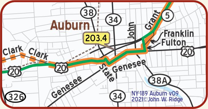 NY-203.4 Auburn
(pop. 36,000, alt. 643 ft.), an attractive summer resort, is situated in the beautiful Finger lake district. One can visit a different lake every day in the week and return to the city at night. On South Street is the old William H. Seward house, where the civil war secretary of state lived; he was instrumental in the purchase of Alaska for the U. S. There is a statue to his memory in Seward park. The town also boasts of several nationally known industries including the Columbian Rope Co., one of the largest rope manufacturing plants in the world, and the International Harvester Co. BB1921-1*
33 South St. Wm. Seward House Historic Museum housed in a home originally built in 1816 but modified and expanded by Seward. Seward was a U.S. senator, a presidential candidate, and then Secretary of State under presidents Abraham Lincoln and Andrew Johnson. Seward is perhaps remembered for negotiating the 1867 purchase from Russia of Alaska, which became known as “Seward’s Folly.” The house is a National Historic Landmark.
180-182 South St. Harriet Tubman Home for the Aged and the Harriet Tubman residence. Both, along with her grave in Fort Hill Cemetery (located near South St./NY 34 between Tubman House and Seward House) have been desiganted as National Landmarks. Tubman was a “chief conductor” on the Underground Railway during the Civil War. The original Home still stands, but was renovated in 1953 by the African Methodist Episcopal Zion Church.
203 Genesee St. Cayuga Museum of History and Art and Case Research Lab Museum. The Museum’s mission has become focused on the Case Research Lab and the history of Cayuga County and the Finger Lakes region. It is housed in the Willard-Case mansion, built in 1836 next door to the Case Research Laboratory.
The Case Research Laboratory is where Theodore Case invented the process of putting sound on film in the early 1920s, creating the “Talkies” for the movie industry. Visitors can tour the lab, see original equipment, and learn about this world-changing invention that came from a backyard laboratory in Auburn, NY.
South Street Area Historic District on the National Register of Historic Places. Roughly, South St. and adjacent properties from Metcalf Dr. to Lincoln St.
NOTE: At least until about 1927 the YT entered Auburn on Clark St. from the west, as it does now, and followed the part of Clark which is now north of US 20. It is difficult to get on and off of that section of Clark. According to both the BB-1919 and 1927, Clark was called Aurelius.
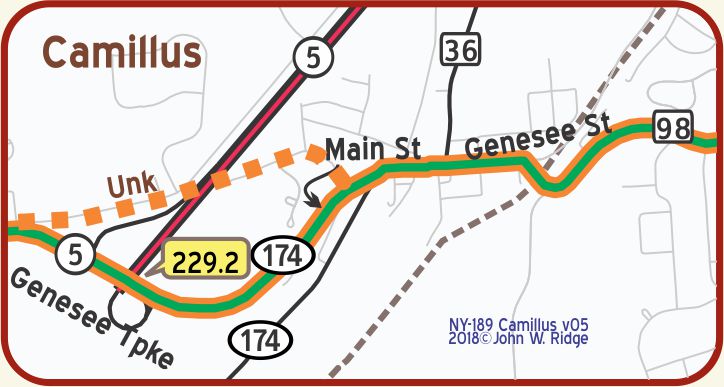 NOTE: NY-229.2 Syracuse – The 1923-1924 highway map of New York published by the Binghamton Automobile Club shows, a “more” main highway from Syracuse to Chittenango following a route not unlike the modern NY 5, but there is no indication that it was used by the YT.
NY-229.2 Syracuse
(pop. 171,717, alt. 400 ft.), is an important commercial center. In 1798 salt works were established here and the manufacture of salt was its leading industry, but now its manufactories are diversified, including the construction of electrical apparatus, automobiles, typewriters and agricultural implements. The Solvay Process Works, at Solvay, west of the city, is one of the most extensive producers of soda products in the world. BB1921-1*
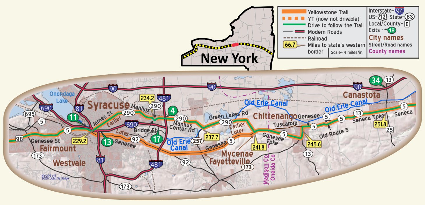 Right from Syracuse on Milton Avenue to the Solvay Plant, 2.1 m., which here manufactures the well-known Arm and Hammer brand of soda. Facing the factories are the employees’ small frame houses, their exteriors crusted with the ever-present limestone ash. WPA-NY*
318 E Erie Blvd. (in the shadow of I-690) the Erie Canal
Museum is a museum about the Erie Canal across New York. It is located in the 1850 Weighlock Building, the only remaining weighlock building in America. The lock was one of five stopping points on the Erie Canal where the state weighed the boatloads of freight to charge a toll.
There are 95 properties listed as being on the National Register of Historic Places in Syracuse. Several of these are on Genessee and James Sts., the Yellowstone Trail, but most are private homes and not open to view. However, the National Registry buildings on the Armory Square Historic District, bounded by S Clinton, S Franklin, Walton, W Fayette, and W Jefferson Sts. give one a view of a Syracuse of 100 years ago.
NY-245.4 Chittenango
1710 Lakeport Rd. Chittenango Landing is a mile north of downtown Chittenango. At the Landing is a Canal Boat Museum with information about canal boats. Outdoors is a restored 3-bay dry dock once used for repairing and building canal boats. Its an easy drive and very interesting.
WAYSIDE – Old Erie Canal State Historic Park runs along the Erie Canal from DeWitte, west of Chittenango to Rome, 36 miles to the east. It is a very skinny park designed for walking or bicycling and accessed from parking lots at the several cross-streets.
NY-251.6 Canastota
(420 alt.,4,113 pop.), is noteworthy architecturally for the preservation of old canal buildings lining the canal. Another unusual feature is the number of wood Second Empire houses, with their flush board surfaces carefully chiseled to simulate stone jointing. WPA-NY*
Canastota is within Old Erie Canal Historic Park.
122 N Canal St. Canastota Canal Town Museum is located in an 1860 canal-era building just across the street from Old Erie Canal Park’s trail in downtown Canastota. The museum displays canal-related artifacts and exhibits on local businesses that thrived because of the canal. It contains a replica of a canal boat’s cabin to give visitors a sense of what it was like to live on the canal.
 NY-254.2 Wampsville
(480 alt.,280 pop.), is the smallest county seat in the State. It was selected as a compromise to settle a dispute between factions favoring Canastota and Oneida. The courthouse, with its dome and its Corinthian portico, lonesomely dominates its rural surroundings. WPA-NY*
NY-257.4 Oneida
(437 aIt.,264 pop.), geographic center of the State, a city of broad, shaded streets and well-kept homes, produces caskets, and period furniture. The establishment of Oneida resulted from a shrewd bargain made by Sands Higinbotham, owner of the city site, with the railroad whereby it received free right of way across his land, plus ground for a station, on the condition that it stop every passenger train at the depot ten minutes for refreshments at Higinbotham’s Railroad House restaurant. Settlers came to this important stop, and Oneida became a thriving village. WPA-NY*
435 Main St. Madison County Historical Society at Cottage Lawn, home of Oneida founder Sands Higinbotham. The museum is furnished with period pieces from the Higinbotham collection along with Madison County artifacts displayed throughout the 19th century home.
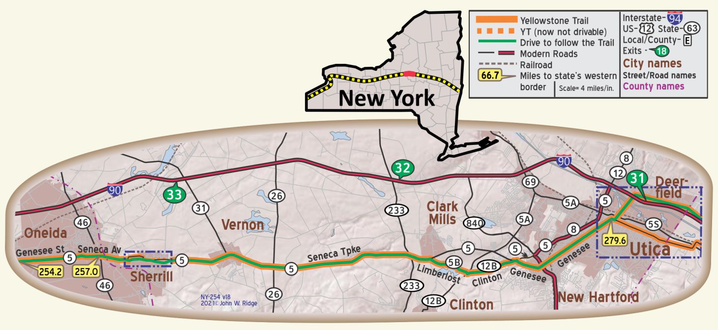
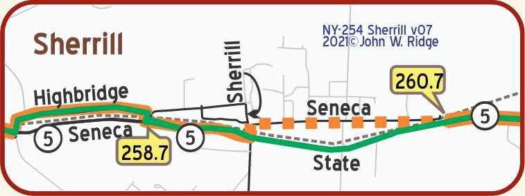 NY-259.7 Sherrill
At the T-junction with Sherrill Road, stand the Oneida Ltd., Factories (open, apply at office for guide), in which Community Plate, the ‘silverware for brides,’ is made. The conducted tour through the plant, a two-and-a-half-hour jaunt, follows the processes of manufacture from raw material to finished, boxed silverware. WPA-NY*
Sherrill is more or less a suburb of Oneida.
The Oneida, Ltd. silver plating company rose out of the ashes of a cult known as the Perfectionists. They were a successful communal society which made silver plate until outside and internal pressures against their “religion” and culture broke up the community in 1881, leaving a company worth $600,000. Cult members were company shareholders, so, although the community dissolved, Oneida, Ltd. was retained and became one of the leading producers of silver plated tableware in the U.S.
170 Kenwood Ave., between Oneida and Sherrill. The Mansion House.
According to their website, The Oneida Community (1848-1880) was a religiously based, socialist group of about 250, dedicated to living as one family and to sharing all property, work, and love. They called their 93,000 square foot home the Mansion House. Today, this National Historic Landmark houses a museum with permanent and changing exhibitions, a gift shop, residential apartments, overnight lodging, and banquet and meeting space.
NOTE: At NY-279.6 Utica:. The YT route south of the river in Utica cannot be followed as well as the northern (NY 5) route. However, on the southern route, the area near Turner St., with its giant abandoned factory that produced Savage Arms and became a huge shopping mall, is a fascinating area to explore, but rough and muddy and depressing. [Late August, 2020, the building was consumed by a gigantic fire.]
The recent intentionally invited influx of refugees from around the world into Utica is fueling a substantial recovery from “rust belt” days.
Note that Turner St. does not cross NY 55, thus interrupting the older YT route. You need to work your way through.
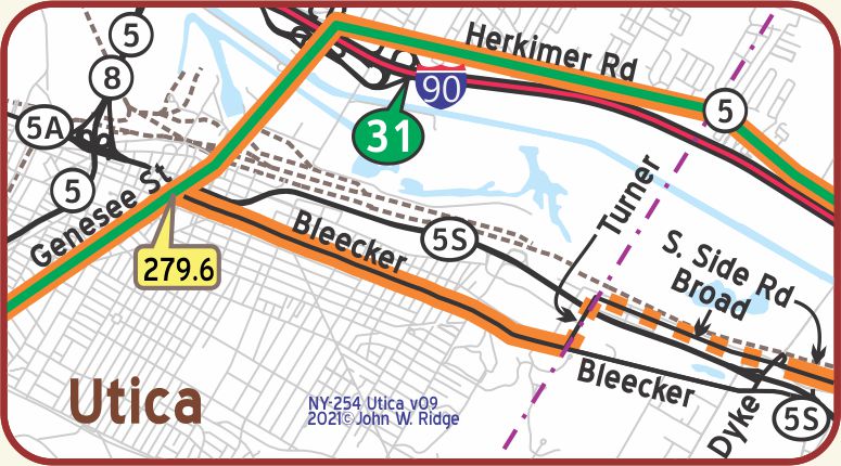 NY-279.6 Utica
(pop. 94,000, alt. 800 ft.), is county seat and largest city in Oneida county and the commercial and industrial center for western section of the Mohawk valley. To the north, a short distance beyond the river and flats, are the picturesque Deerfield hills, beginning of the scenic highlands which stretch away toward the Adirondacks and the St. Lawrence river. WPA-NY*
Utica has grown in population and wealth principally thru its extensive manufactures. It is clearly linked with the surrounding country by road and rail; and has interurban electric service. The section of which Utica is the center is one of the largest producers of dairy products in the state, and perhaps the most important eastern cheese market. BB1921-1*
One enters here the Mohawk Valley that follows the Mohawk River and Erie Canal east.
1608 Genesee St. Oneida County Historical Society
Museum. The Society was founded in 1876 and has served since that time to collect, preserve, and make accessible the past heritage of Oneida County and the upper Mohawk River Valley. Services center around a research library, a museum exhibit area, and weekly programs featuring guest artists, authors and historians. See the History of Transportation exhibit.
3 Rutger Park. Roscoe Conkling House, 1829. Conkling was a powerful, controversial Republican politician in a volatile political age, 1860s to 1880s. Conkling believed in protective tariffs and was against civil service reform, preferring political appointments. It is on the National Register of Historic Places. At this writing the Conkling house is slowly undergoing a much needed restoration. Joe Parmley, founder of the Yellowstone Trail Association, was such a fan of Conkling’s that in 1885 when Parmley arrived in South Dakota, he named his fledgling town Roscoe. The town is still there and is still so named.
Genesee and Bleeker Sts. are old streets, both on the Yellowstone Trail. About 10 properties are listed on the National Register of Historic Places in addition to the below. As you drive, note the gracious, historic buildings that were standing right there when the Yellowstone Trail travelers drove these streets 100 years ago.
Lower Genesee Street Historic District National Register of Historic Places. Roughly bounded by Genesee, Liberty, Seneca, and Whitesboro Sts. (both sides).
259 Genesee St. Stanley Theater. Originally built to be a movie palace, the Stanley opened on September 10, 1928 with 2,963 seats. On the Register of Historic Places, it now features live performers and community productions.
841 Bleecker St. (Yellowstone Trail). Memorial Church of the Holy Cross built 1891. This Episcopal Church right on the Trail may have been visited by Trail travelers 100 years ago. It is on the National Register of Historic Places.
102 LaFayette St. Hotel Utica. The date was March 11, 1912 when the hotel opened its doors. It was an era of prosperity and growth for our nation. Developers could afford to build with elegance. As their website says, “It was a time when gentlemen tipped their hats to ladies – a time when white-gloved hands held open doors with a welcome gesture. Saluting bellhops jumped eagerly for luggage and for tips.
It was a time when Judy Garland sang bird-like for guests from the mezzanine, and Mickey Mantle signed autographs out front for crowds. If the walls of this hotel could talk, they would tell the stories of Eleanor Roosevelt’s visits to the
kitchen to compliment the chef for his Bananas Foster, or perhaps of F.D.R.’s trips to the Gentlemen’s Cafe to relax after the Democratic Convention.”
We stayed recently in this great place which has managed to keep its historic aura in public spaces such as in its beautiful lobby. It is now a Double Tree by Hilton hotel.
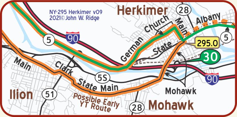
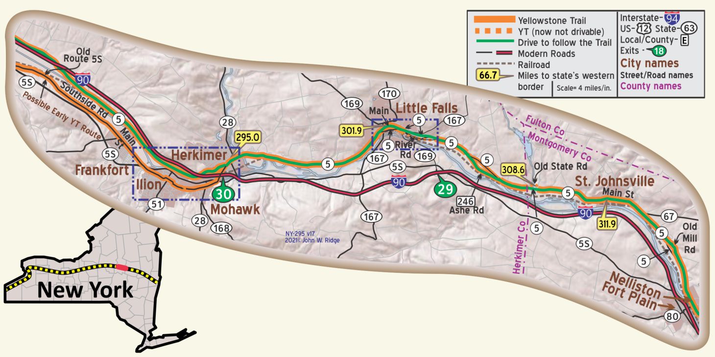 NY-295.0 Herkimer
(pop. 7,520, alt. 406 It.), the seat of Herkimer county, in a picturesque section of the Mohawk valley, near the mouth of West Canada creek. Like many another Mohawk Valley town, Herkimer is an industrial center and a shipping point for dairy products. The principal industry is the manufacture of roll top desks. BB1921-1*
The Standard Furniture Plant, at Washington St. and Eastern Ave. a six-story brick building covering an entire village block, is one of the largest producers of office desks in the United States. WPA-NY*
 The Erie Canal runs along the southern border of Herkimer. In 2000, the United States Congress designated the historic route of the Erie Canal, as the Erie Canalway National Heritage Corridor.
400-406 N Main St. at Court St. The Herkimer County Historical Society Museum traces 200 years of agriculture, industry and life in Herkimer County.
NOTES:
NY-293.0 – NY-295.0: Southside Rd. (old 5 S) is a good, mostly rural road with no view of the canal.
NY-295.0 Herkimer: At GPS: 43.02874, -74.97377 is a tree-covered aqueduct of the old Erie Canal.
NY-302.3 through NY-304.3: The YT route is open only on the west end, but provides a glimpse of the old road construction and the canal and locks. Had a good picnic near the sewer treatment plant.
NY-308.6: New bridge going around old YT bridge.
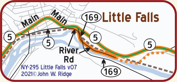
NY-301.8 Little Falls
There are beautiful drives along the Mohawk river. The barge canal and Lover’s Leap offer an inspiring view on the south side of this stream. BB1921-1*
 Occupying both sides of the Mohawk River, Little Falls, (440 alt.,10,112 pop.), is an industrial city with dilapidated taverns on the canal banks and stately Victorian mansions on the crooked, hilly streets. A boom town of the old Erie Canal era, the city has never outlived the influence of that waterway; and its successor, the Barge Canal, remains an integral part of industrial and mercantile life. WPA-NY*
The region became the largest cheese market in the country. Herkimer County cheese is still a favored trade name for the products of the middle western States. The ruined three-arch Aqueduct, foot of Bridge St., was erected in 1822 to provide access for boats from the Erie Canal on the south bank of the Mohawk to Little Falls on the north bank. The 70-foot central arch still stands; although the northern pier is fast disintegrating, the ruins are interesting as revealing the interior structure of the masonry. WPA-NY*
The Little Falls Gorge is a rugged pass where the valley tapers down to a narrow cut. Two highways, two railroads, and the Barge Canal squeeze through between the sheer stone cliffs. The river here is a mad raceway, supplying water power to the factories that line its bank; the Barge Canal is a one-mile channel cut through solid rock. WPA-NY*
In Little Falls at the corner of E Main St. and NY 5 turn south on River Rd., go 0.6 of a mile. There you will see old Lock E17 on the Mohawk River/old Erie Canal. GPS: 43.03795, -74.84312.
319 S Ann St. Little Falls Historical Society Museum.
Little Falls Gorge at Little Falls is one of the great faults or dislocations of the earth’s strata, which mark the southern Adirondack region. It runs from the south east side of Little Falls to the Pinnacle, 10 miles northwest and two miles north of Dolgeville. The bottom of the Gorge is the channel of the great Iromohawk River in which the modern (25,000 years old) Mohawk River has carved a smaller channel. The Gorge walls rise 300 feet. The Little Falls Gorge, with its exposed rock and strata forming a record of geological history and its evidences of titanic water and glacial forces, is a place of much interest to geologists. WPA-NY*
WAYSIDE – 123 Old State Rd. about 7 miles east of Little Falls is Beardslee Castle. The Beardslee family had a long history in New York, producing engineers, statesmen, builders, lawyers and investors. The “castle” was built in 1860. A small power plant was added and Third generation Beardslee, Guy, succeeded in mechanizing his farm and those around him. This was to become the first rural electric power in the country.
After a tumultuous 100 years including fires, repeated flooding, a failed eatery and on-and-off abandonment, it is now a beautiful restaurant with the bar in the “dungeon.” One can view the whole valley through the second floor banquet room’s floor-to-ceiling windows.
Unfortunately, Yellowstone Trail travelers would have driven right past the shambles in the 1920s. •
About one mile farther east is an arched bridge which carried the Yellowstone Trail and then later NY 5 traffic over Upper Canada Creek.
Workmen at the site with whom we chatted were interested in the fact that the Yellowstone Trail ran on that bridge before NY 5.
NY-311.9 St. Johnsville
(360 alt.,2,283 pop.), is a mill town producing felt shoes and underwear and a farm shipping and trading center. The village displays several interesting Greek Revival houses, those at 30 Bridge St. and 11 and 13 Washington St. being especially notable.
WPA-NY* [Note: 11 and 13 Washington St. are half a block from NY 5/ Main St./Yellowstone Trail].
This is another town which owed its economic existence to trade on the Erie Canal.
Just east of the south end of the Bridge St. bridge over the Mohawk River is Enlarged Double Lock No. 33 Old Erie Canal, now filled in. It is an historic Erie Canal lock. It was built in 1824 and enlarged in 1840. The south lock was enlarged in 1888. It is built entirely of large cut limestone blocks mortared with hydraulic cement. Lock 33 fell into disuse after the opening of the New York State Barge Canal in 1918. Since 1997, it has been reclaimed and restored by local volunteers. When we saw it recently, it was filled in with soil but still recognizable as a narrow lock.
It was added to the National Register of Historic Places in 2002.
Two miles east on NY 5 is Fort Klock (GPS: 42.98576, -74.64882). This is just a single fortified 1750 house built by Johannes Klock, not a fort in the Western sense with military barracks, etc. Citizens fortified their homes and sheltered their neighbors in times of crisis against Indians or the British, depending upon the year. This one contains 18th and 19th century exhibits and some antiques. A schoolhouse, Dutch barn, and blacksmith shop are also there.
WAYSIDE – Saltsman’s Hotel Restaurant. An historically interesting place about 10 miles north of the YT in Ephratah. Go north of Palatine Bridge and east of St. Johnsville at Ephratah. “Celebrating over 200 Years as a Destination Restaurant.”
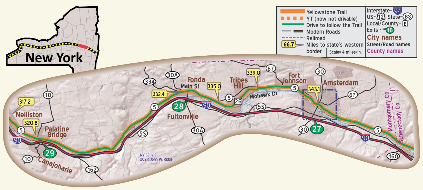 NY-332.4 Fonda
(300 alt., 1,120 pop.), is an important manufacturing village and freight transfer point. The main street faces on the railroad right-of-way, and the frame homes climb the hillside. The Fonda, Johnstown & Gloversville Railroad, which provides a freight outlet for the glove district, carries principally animal products and gloves. Fonda itself is a center for the manufacture of fabric gloves. In the summer its busses carry vacationists to southern Adirondack lake resorts. WPA-NY*
Fonda was named for an ethnic Dutch settler, Douw Fonda, who was scalped by Indians during the Revolutionary War. Henry Fonda, the famous actor, wrote about his ancestors in his 1981 autobiography:
Early records show the family ensconced in northern Italy in the 16th century where they fought on the side of the Reformation, fled to Holland, intermarried with Dutch burghers’ daughters, retained the Italianate name ‘Fonda.’ Before Pieter Stuyvesant surrendered Nieuw Amsterdam to the English, the Fondas, instead of settling in Manhattan, canoed up the Hudson River to the Indian village of Caughnawaga. Within a few generations, the Mohawks and the Iroquois were butchered or fled and the town became known to mapmakers as Fonda. My Life by Henry Fonda (New York: Dutton, 1981).
NY-340.6 Fort Johnson
2 Mergner Rd., Old Fort Johnson, Montgomery County Historical Museum. Old Fort Johnson is the original 1749 limestone house, on the north bank of the Mohawk River, built by Sir William Johnson, the British Superintendent of Indian Affairs. A pallisade was built around the house during the French and Indian Wars, thus the name of “Fort Johnson.” Like Fort Klock, this is just a house fort.
The Old Fort is a museum showing the social, cultural, military, and industrial past of the Mohawk Valley. The Old Fort has been the setting for many historical books. Read about its exciting history at www.oldfortjohnson.org. It is on the National Register of Historic Places.
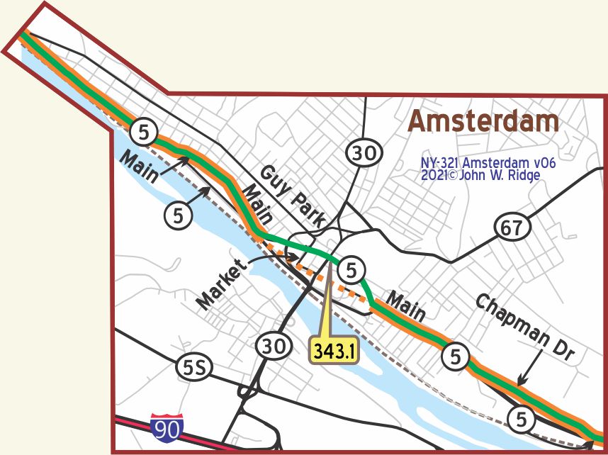 NY-343.1 Amsterdam
The city of AMSTERDAM (288 alt.,33,640 pop.), straddles the Mohawk River at the mouth of Chuctanunda Creek, which has supplied water power to local industries. Guy Park Avenue, two blocks north, is in its western part a street of well-kept mansions on landscaped grounds. The rest of the city is given over to the frame and brick homes of workers and the heavy brick buildings bordering boisterous Chuctanunda Creek, within which are produced rugs and carpets, brooms, underwear, fabric gloves, linseed oil, and pearl buttons. In normal times more than 9,000 people are employed and large quantities of wool, silk, and flaxseed are imported as raw materials. More than half the population is mainly Italian and Polish. WPA-NY*
NOTE: Amsterdam has one-way streets and some convoluted traffic patterns. You may have to explore a bit!
Amsterdam hosts at least 15 properties on the National Register of Historic Places. It also shares the honor of the New York State Barge Canal on the Register with Canajoharie, Fonda, Glen, Minden, Mohawk, Palatine and St. Johnsville.
366 W Main St. ( Yellowstone Trail ) Guy Park, also known as Guy Park State Historic Site and Museum, is a house built in 1774 in the Georgian architectural style for Guy Johnson, the nephew and son-in-law to Sir William Johnson, 1st Baronet, the British Superintendent for Indian Affairs in colonial New York. [See Fort Johnson above, and yes, Guy married his cousin Molly.] It sits just behind railroad tracks off Main St. in the heart of Amsterdam. The mansion underwent substantial renovation due to Hurricane Irene in 2011.
Directly to the rear of Guy Park is Lock No. 11 of the Barge Canal where the locking of canal barges was once observed. The floodgates, or movable dams, were raised in winter to allow the ice free passage and were lowered during the canal season to regulate the flow of water.
The Mohawk Carpet Mills and Bigelow-Sanford Carpet Mills and others operated here for over 100 years due to easy canal transportation and water power supplied by the 300 foot drop in the rapidly flowing Chuctanunda Creek. Imports of wool, cotton, dyes and jute supported the employment of thousands, and the survival of an industry. By the mid 20th century the mills began closing, lured by newer factories in the south and cheap labor in China. Today the town is engaged in renewal efforts.
Just west of Amsterdam there is a viewing place for visitors to see the Erie Canal. Locks #12 and #11 are along NY 5. The old Erie Canal was a dug canal, but from 1909 to 1912 they “canalized” the Mohawk River, putting in locks and dams.
NOTE: NY-357.5 Scotia: The YT Bridge over the Mohawk River has been redone. 1920 AAA strip map suggests it was more north/south than now.
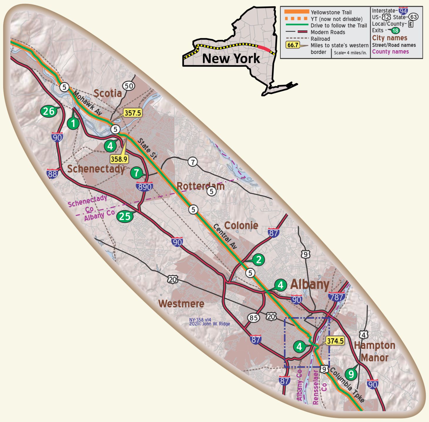 NY-357.5 Scotia
Erie Canal Lock #9. Continuing on NY 5W, about 3 miles west of Scotia, NY 103 S joins NY 5. The entrance to Lock 9 Park in Rotterdam Junction is just south of the intersection, before the bridge. The Erie Canal has been enlarged to encompass the Mohawk River.
1 Glen Ave. The Glen-Sanders House. Set alongside the Mohawk River, this historic home was built in 1658 by Alexander Lindsey Glen, Agent for the Dutch West India Company and fur trader. Astonishingly, the kitchen of this house, part of the original one room dwelling, still stands! He named this settlement “Nova Scotia,” or New Scotland. Over the years, additional rooms were added to this substantial stone home by Glen and his son Abraham.
The Glen Family was host to many historical figures including General George Washington.
In 1765, Alexander Glen’s great-granddaughter, Debra Glen and husband John Sanders became the sole owners of the Glen Estate. From that date until 1961 the house remained in the possession of the Glen family handed down from generation to generation. Today it is an inn.
14 Mohawk Ave. (NY 5/Yellowstone Trail). The Abraham Glen house was built in 1730 by the son of Johannes Glen from the Glen-Sanders Mansion. The house stayed in the family until 1842. Then the Collins family bought it and that is when Collins Park began. It is possible that there was an underground passage to escape Indian attacks or other enemies. Slaves also lived in the house. It is a rare surviving example in the region of a Dutch Colonial heavy timber frame house. It was extensively modified at the beginning of the 20th century but still retains its basic form and original materials. In 2004 it was listed on the National Register of Historic Places.
NY-358.9 Schenectady
Don Rittner, Historian of Schenectady County, wrote in the present Yellowstone Trail Association 2005 Fall newsletter, the Arrow, that “In Schenectady County, approximately 14 miles from three historic roads made up our part of the Yellowstone Trail: the 1663 King’s Highway, the 1802 Albany-Schenectady Turnpike, the 1926 US 20/NY 5.”
The Schenectady Times Union.com reported in December 27, 2005, that the city of Schenectady recently passed a resolution to designate that 14 mile section of Schenectady County as the Yellowstone Trail.
432 State St. (Yellowstone Trail). Proctor’s Theater. Built in 1926 by F. F. Proctor, Proctor’s on State St. in Schenectady was a popular vaudeville theater. In 1930, Proctor’s hosted the first public demonstration of television with the help of General Electric. However, the Great Depression led to the decline of the theater.
After changing hands multiple times and almost being torn down in the 1970s, a group of concerned citizens banded together to save Proctor’s. It re-opened in 1979 and since then, it has become the motivating factor for the revitalization of Schenectady’s downtown area.
15 Nott Terrace Heights. The Schenectady Museum of Innovation and Science.
In 1887, Thomas Edison moved his Edison Machine Works to Schenectady. In 1892, Schenectady became the headquarters of the General Electric Company. GE has retained its administrative core in Schenectady, but many of the manufacturing jobs have been relocated to the Sun Belt and abroad.
The museum maintains an archive of historical GE information and photography in its Hall of History. The archives also include 110 radios, 60 televisions, 15,000 patents, 5000 books, and 1000 films. Many of the items relate to the history of Schenectady and General Electric.
In an area bounded by Lenox Rd., Nott St., West Alley and Union Ave., the Yellowstone Trail traveler, just as today’s traveler, would find some 130 homes dating from the early 1900s when the neighborhood was created as an exclusive residential community for corporate executives of General Electric.
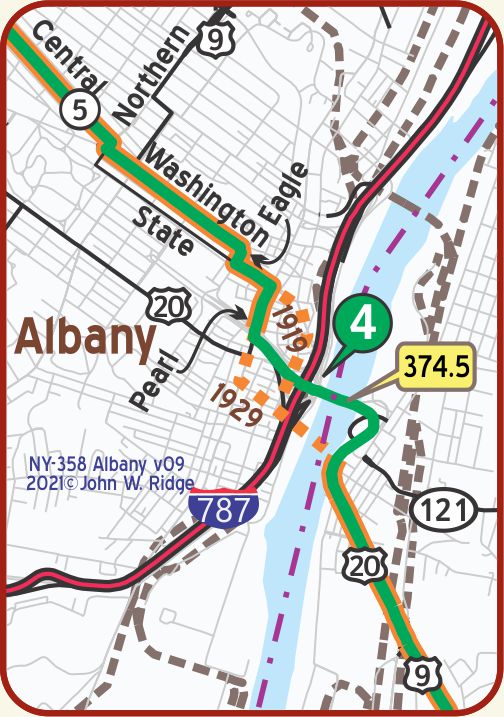 NY-374.0 Albany
Albany was the meeting place of the first Colonial congress, held 1754, to formulate a plan for a union of the several colonies. It was also the key to the primitive highway of central and northern New York which the French and Indian and revolutionary wars brought into new importance. During these conflicts military expeditions frequently passed thru en route to lake George, lake Champlain, Canada, lake Ontario and the Niagara frontier. WPA-NY*
Between Albany (130,447 pop.) and Schenectady, State 5 is bordered by almost unbroken lines of small suburban homes occupied by commuters to the two cities. WPA-NY* [Note: State hwy 5 was the Yellowstone Trail]
Nearly all departments of the state capitol are open to the public several hours a day; also the state museum. BB1921-1*
In the Educational building (Washington avenue, nearly opposite Capitol) is the state library, one of the best schools for librarians in the U. S. BB1921-1*
Albany exhibits a dramatic skyline with the capitol showing prominently.
9 Ten Broeck St. Ten Broeck Mansion, home of the Albany County Historical Association. Built in 1797-98 for the Ten Broeck family, then eventually given to Albany County in 1948. A variety of programs is given focusing on the history and culture of Albany.
State St. and Washington Ave. New York State Capitol. The Yellowstone Trail runs right past the iconic capitol building on Washington St. It opened in 1899 and was a show-stopper for the Yellowstone Trail travelers when they passed by around 20 years later.
Washington Park and neighborhood is designated Washington Park Historic District because of the many historic houses facing the park, each with its own story, and the story of the park itself. As far back as 1686 the park area was deemed public property by city charter and has been so used ever since. The park lies between Madison Ave. and State St., from Willett to Lake Sts., 81 acres including a lake. It was named Washington Park in the early 1800s.
547 Central Ave. (Yellowstone Trail). West Hill. Jack’s Diner. Another diner, you say? Well, yes. Diners are an Eastern phenomenon and this one is on the Yellowstone Trail. We wanted to include Miss Albany Diner, which is on the National Register of Historic Places, but sadly, it is closed. Forever.
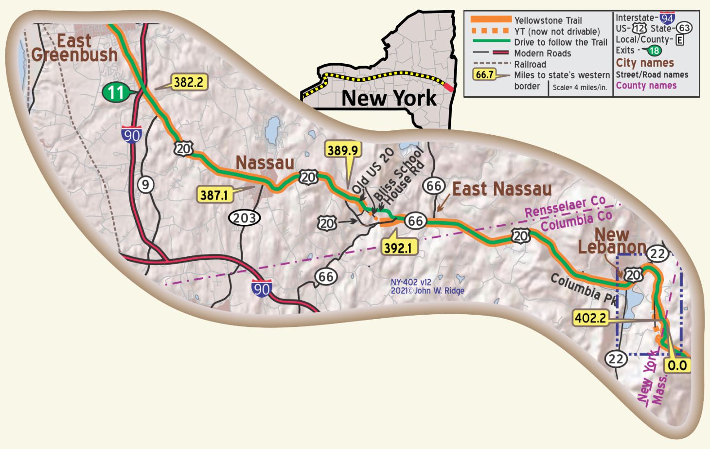 NY-399.8 New Lebanon
Between New Lebanon and the Massachusetts border is the site of the Shaker Museum/Mount Lebanon Shaker Society.
[This Shaker Village is not to be confused with the more advertised Hancock Shaker Village a few miles to the east in Massachusetts.]
It can be reached from NY-401.4 by following the original Yellowstone Trail running on Darrow Road or from NY-399.8 (at New Lebanon) running on Shaker Road.
This National Historic Landmark holds the remnants of a Shaker settlement of 1787. The United Society of Believers in Christ’s Second Appearing is more commonly referred to as “Shakers” because of the very active singing and dancing related to their religious services.
The website https://www.shakermuseum.us/ describes the religion thus:
The Shakers believe in the millennialist principle of establishing “heaven on earth” through the practices of communitarian social organization, pacifism, celibacy, gender equality, and the public confession of sin.
There is still a Shaker community in existence in Maine.
The Museum’s holdings span over 200 years related to all aspects of the American Shakers. The museum is in the 1854 Wash House and features special programs and events. The Visitors’ Center is in the 1838 granary. Several buildings such as the Meeting House (1787), the Great Stone Barn (1860), the Poultry House (1870) and the Brethren’s Workshop (1829) are in different areas of the property. Did you know that the first free lending library in the U.S. (1804) was here? Other religious retreat groups use some of the10 buildings and 30 acres of the original village, as does a private boarding school, the Darrow School. Entry to the historic buildings is by guided tour only.
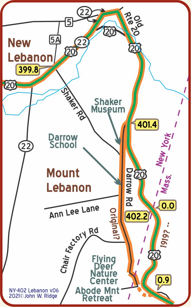 NOTE: At NY-401.4, there is an intersection of US 20 and Darrow Rd. Various of the Automobile Blue Books and other sources result in some confusion about whether the YT initially followed Darrow Rd. or the “new” road, now US 20, at the New York/Massachusetts border.
It is probable, but not established, that the original route of the YT followed Darrow Rd. and intersected the modern US 20 at MA 000.9, at a point across US 20 at the east end of the existing wayside. *See USGS maps and Google Maps Earthview.
Driving Darrow Rd. today provides an up-close view of the Berkshires and an interesting visit to a lesser known Shaker village and its museum as well as an overgrown section of a pre-1900 road. Some of the historic Shaker buildings in this rural area house the Darrow School, a New England private high school (founded 1932), the Flying Deer Nature Center, and the Abode Mountain Retreat.