
 The map’s green circle markers
are modern highway exit numbers
used for current location reference.
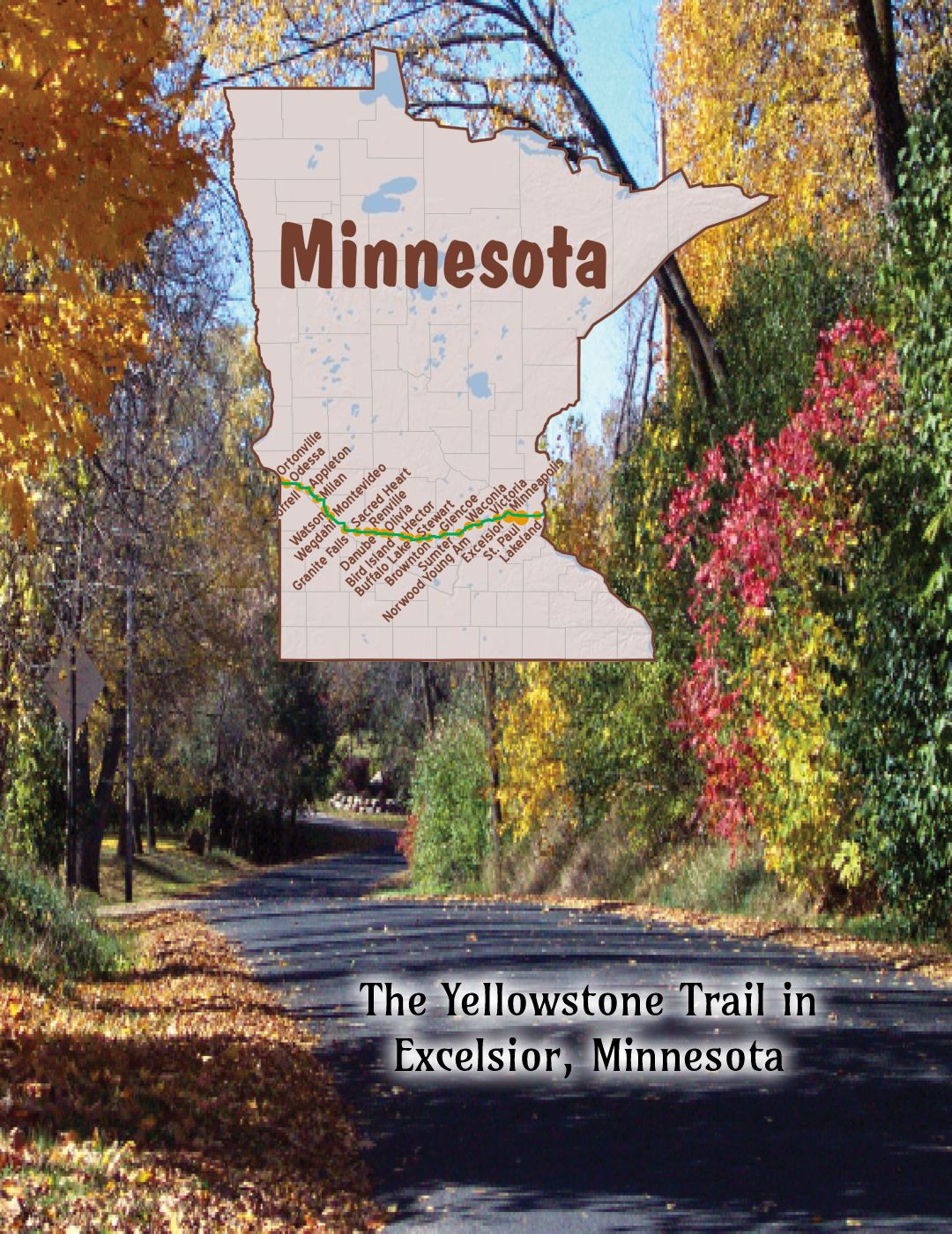
 The map’s yellow rectangle mile markers show path of YT and distance to state’s west border. Click the corresponding number in text for directions and more information.
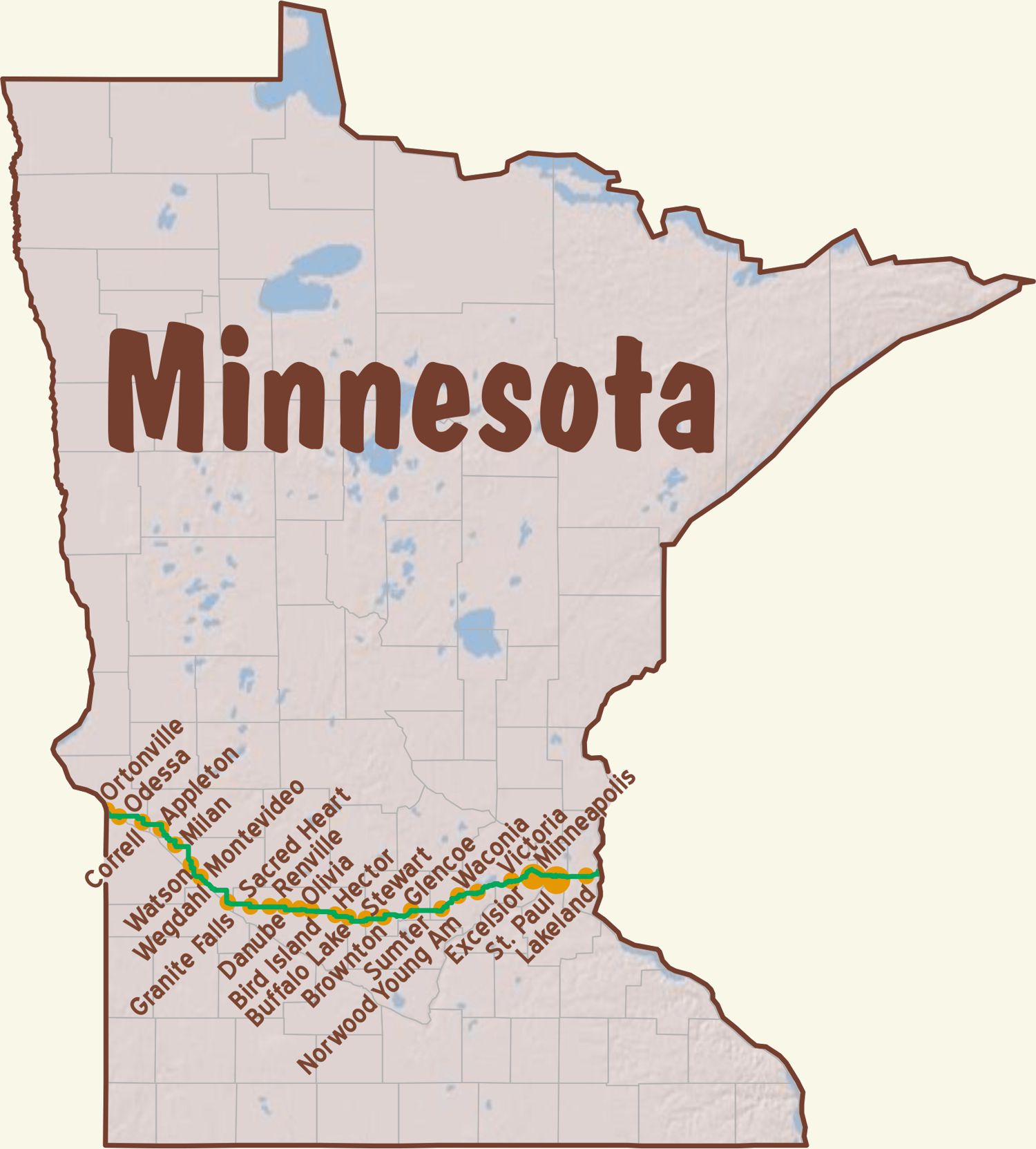
 For Directions, click the Minnesota (MI-) State YTA Mile Marker Numbers (below) linking you to a real-time map.
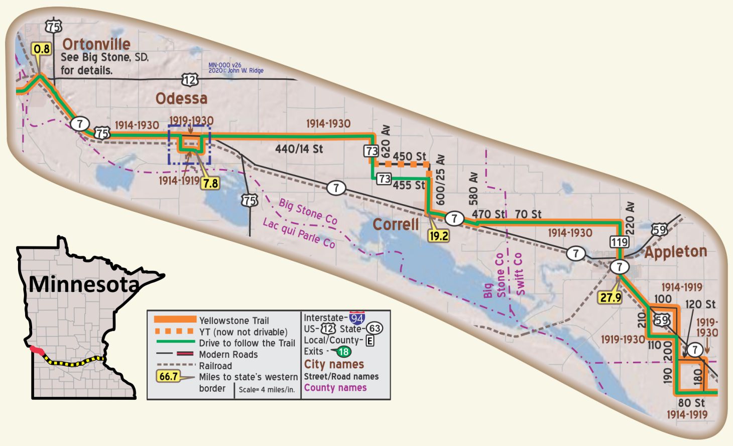
MN-000.0 S. Dakota/Minnesota Line
MN-000.8 Ortonville
pop. 2,500, alt. 990 ft.), situated at the foot of Big Stone lake, a body of water nearly a mile wide and about thirty miles long, is a summer resort of considerable importance. The scenery of the Minnesota valley and along Big Stone lake is most picturesque and attractive. BB1921-10*
COLUMBIAN HOTEL modern and well kept; all outside rooms. A. P. $3.25; with bath $3.75; breakfast 50c; lunch or dinner 75c.
H. J. McDOWELL GARAGE services all cars and reputed best. Open late. Ph. 24-J. MH-1928*
Today the town is known for its granite-quarrying and canning industries. Seven large quarries operate throughout the year and provide an income to hundreds of families. WPA-MN*
The Big Stone Lake Area comprises Ortonville, the Big Stone Lake and Park, and crosses the state line to Big Stone City, South Dakota. The area jointly features many outdoor activities connected with the lake. There is also hunting and a corn festival. The lake is the headwaters of the Minnesota River. From here to Granite Falls you are in the Minnesota River Valley.
Between Ortonville and Big Stone Lake is an abandoned Marsh Rainbow Arch Bridge which crosses the Minnesota River. It once carried the Yellowstone Trail.
Click Here for Ortonville’s Marsh Rainbow Arch Bridge History.
The bridge is a fine example of a now rare concrete bridge type. It can be seen from the US 12 bridge, and you can get closer by taking County 37 which turns off of US 12 and walking a bit. It is a footbridge now. Similar bridges near the Yellowstone Trail can be found in Anaconda, Montana, and Chippewa Falls, Wisconsin.
Big Stone County Historical Museum Jct. Hwys 12 and 75. You can’t miss this. There is a huge coat hanger-like sculpture set in concrete in the yard. It is called Paul Bunyan’s boat anchor. The museum features wildlife collections. Note the Yellowstone Trail sign displayed in the front yard. See also the 1909 “Muskegon Boat” that once plied the waters of Big Stone Lake.
Ortonville Commercial Historic District 2nd St., Madison and Monroe Aves., between Jefferson and Jackson Aves. GPS: 45.30611, -96.44639. Long-serving commercial district is noted for its uniform Victorian buildings. It is representative of the region’s small towns but unique for their purple granite trim, and the district contains 19 properties built between1879 and 1922.
A downtown landmark, the 1892 Columbian Hotel, burned down in 2012, another historic loss for the traveler on the Yellowstone Trail.
MN-007.8 Odessa
Odessa and towns south (Correll, Appleton, Milan) are prime sites for bird watching: white pelican nesting colonies, flyway zones, and shorebirds which have been migrating through the area for eons. Yellowstone Trail travelers of 100 years ago may have watched just as present travelers are now doing.
Big Stone National Wildlife Refuge, just south and east of Odessa, is home to 230 bird species.
Main Ave. and 2nd St. GPS: 45.25973, -96.32894. Odessa Jail is Odessa’s oldest public building, built in 1913. It is a rare surviving example of the freestanding brick jail houses once common in small Minnesota towns (also seen in Montana).
MN-019.2 Correll
pop. 180; garage, gas and supplies. Small pay camp, 25c. MH-1928*
MN-027.9 Appleton
pop. 1,700; a grain growing and dairying center. Brown’s Hotel has running water; dbl. $1.75. APPLETON AUTO CO., Ford, finely equipped and best for all makes. Labor $1; phone 235 for tow car until 10 p. m. MH-1928*
Bordering the river in the northeastern section of Appleton is a beautiful park, formerly a slum district. It was recently laid out and constructed as part of a Federal relief program. WPA-MN*
All of its 32 streets, except Minnesota St. are named for local veterans who died in combat.
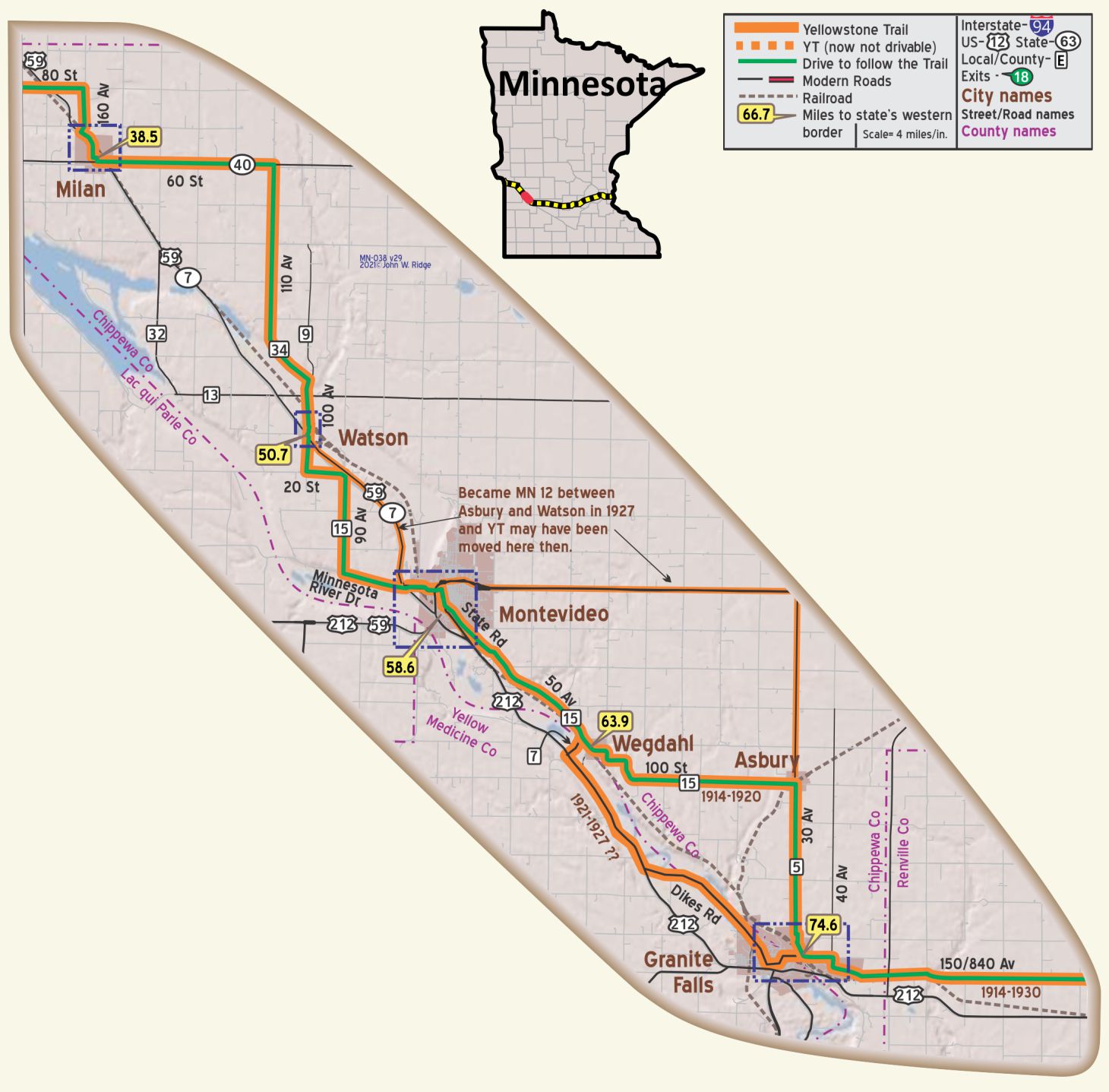 MN-038.5 Milan
pop. 600; a center of diversified farming. Halling’s Garage is good. Nelson’s Hotel has running water and serves good meals. Free camp space. MH-1928*
Whether the town of MILAN (1,010 alt., 548 pop.) 95 per cent of whose citizens are Norwegian, was named for the Italian city, is not known. An unusual gala event, the Lefse Fete, is held in Milan in August. WPA-MN*
Today Milan is still a leading center of Scandinavian culture and ethnic arts.
Route of YT on 2nd in Milan is uncertain.
MN-050.7 Watson
Goose Capital of the World.
Click here for information.
WAYSIDE – Running just south and west of the Yellowstone Trail along the Minnesota River between Ortonville and Watson are various state and federal wildlife management areas known for bird watching. Just north of the Lac qui Parle Mission and about two miles west of the Trail is Lac Qui Parle State Park, known as a stopover for thousands of migratory Canada geese, bald eagles, pelicans, and other waterfowl. GPS: 45.02370, -95.86860.
NOTE – This section gives a feeling for the indirectness of the original YT and some sections are gravel. The pavement around MN-021.3 is marked “minimum maintenance” but was quite driveable in recent years.
WAYSIDE – Just west of Watson and south of Milan near the junction of Co 13 and Co 32 at the Minnesota River is Lac qui Parle Mission. The site was established in 1835, where the first Dakota dictionary, grammar, and gospel were completed. A chapel built by the WPA features artifacts and exhibits related to the Dakota and missionaries who worked with them.
MN-058.6 Montevideo
Between Montevideo and Granite Falls the route is in the valley of the Minnesota River.
pop 4,900; a county seat and has beautiful 30-acre park on Chippewa River; a great shipping point for hogs and milk-fed chickens. Eandguard’s Cafe is best. Pine camp site in park.
HOTEL RIVERSIDE modern and very well kept; sgl. $1.25-$1.50; dbl. $2; with bath $2.50-$3.
CLAY MOTOR CO., leads by far; 24 hr. serv.; Labor $1; phone 165. MH-1928*
(922 alt., 4,319 pop.), seat of Chippewa County, was named for the capital of Uruguay; Smith Park, on the western edge of town, is a 35-acre Tourist Camp (free kitchen facilities). The bluffs of the city offer a remarkable panorama of the merging valleys of the Minnesota and Chippewa Rivers. WPA-MN*
151 Pioneer Dr., Jct. of Hwys 212 & 7 Chippewa City
Pioneer Village. Here is a “must see.” About a mile north of Montevideo you will come upon Historic Chippewa City. It was platted in 1868. Then Montevideo was platted in 1870 and Chippewa City ceased to exist. Today one can see it rebuilt in 24 buildings preserved or period buildings moved in from various locations in the county. It is operated by the Chippewa County Historic Association. It’s fun to stroll there through yesteryear.
Along the Minnesota River is the Lagoon Park, there since 1919 and now a modern camp ground with all of the current facilities.
301 State Rd (Yellowstone Trail). Milwaukee Road Heritage Center Museum at the restored 1903 Milwaukee Railroad Depot. The place has equipment, memorabilia, and facilities to show what transportation was like in Montevideo for almost a century.
MN-067.5 Olof Swensson Farm
Museum
John Swensson turned his father’s original farmstead into a museum. The farmstead consists of 17 acres, an 1880s timber-framed barn, grist mill remains, family cemetery, and a 22 room brick farmhouse. Constructed in 1901, the house contains original furnishings from this unique Norwegian/Swedish family. We were surprised to see a sizeable family chapel within the farmhouse. It is listed in the National Register of Historic Places.
MN-074.6 Granite Falls
pop. 1,800; in midst of fine stock and grain farms. Keegan Hotel has rooms with running water. Winter Garage is largest. Free camp on river, is fair. MH-1928*
(922 alt., 1,791 pop.), is on a boulder-strewn bluff overlooking the Minnesota Valley. In the valley Archean granites are exposed; these rocks belong to the oldest era of geological history. The founders of the town were attracted by the power possibilities of the falls. WPA-MN*
At Granite Falls Dam, if you are there in early summer, notice the beautiful American White Pelicans in residence when the water is high. With large, black tipped white wings, these great birds dive gracefully and live seemingly cooperatively.
On the northern edge of town, running NW to SE is Dikes Road, a gravel road on top of dikes. The Yellowstone Trail of 1921-30 ran on this road.
163 Ninth Ave. Volstead Museum. This was the home of Congressman Andrew Volstead, most known as the author of the Volstead Act which enforced the 18th amendment to the U.S. Constitution which banned the production of alcohol (known as Prohibition). It was ratified in 1919 and repealed in 1933 with the 21st amendment. He also authored the important “Cooperative Act” which allowed farmers to band together to bargain with companies for a fair price. Agricultural “cooperatives” still stand today.
At MN 23 and MN 67 near the Minnesota River is the Yellow Medicine County Historical Museum. This museum’s displays tell a story of the geology and archaeology of the Minnesota Valley, Native American history, and pioneer life in the county. Ask them about the oldest granite in the world, granite gneiss about 3 billion years old, that is visible in the area.
WAYSIDE – Nine miles south of Granite Falls in Hanley Falls is Minnesota’s Machinery Museum. A five-building complex displays a large collection of tractors, vintage cars, old farm implements, and a farm house used in Yellowstone Trail days.
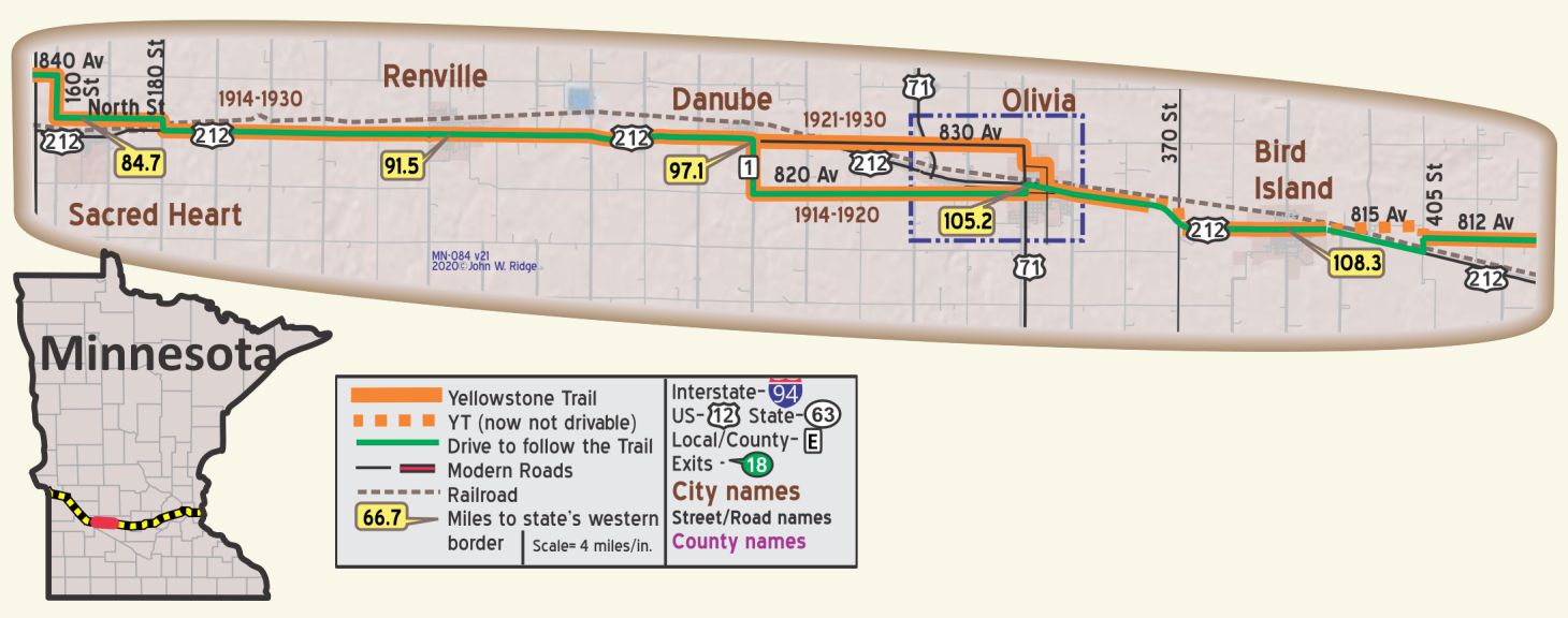 MN-084.7 Sacred Heart
pop. 800; named by the Indians, not a Catholic town; has some of largest quarries of best granite in the state. Free camp space in City Park
SACRED HEART HOTEL most pleasant and claimed best between Aberdeen and Minneapolis; sgl. $1.25-$1.75; dbl. $2; with bath $2.50. Breakf. 50c; dinner 75c; no lunch.
STAVNE’S GARAGE, is best for repairs; labor 75c; open until 11 p. m. MH-1928*
The 1914-built Sacred Heart Hotel on the main drag is still there!
The Sacred Heart Historical Society won National Register of Historic Places status in May, 2018 and is in line to receive grants from the Minnesota Historical Society to preserve the building for reuse.
300 5th Ave. W (US 212) Sacred Heart Area Museum. It is in a Lutheran church built in 1916 and displays and preserves the history of the Sacred Heart area.
MN-091.5 Renville
202 N Main St. Renville City Historical Museum in a late 1800s schoolhouse. The museum features many materials regarding former resident Michael Dowling, an amazing man who, despite triple amputations, was a “Good Roads” leader, teacher, and newspaper publisher. He later moved to Olivia where he was a banker, garage owner, president of the Yellowstone Trail Association 1917-1918, and friend of President William McKinley. For Dowling’s inspiring biography, see Trail Tale: Dowling, page <?>.
MN-097.1 Danube
pop. 300; country hotel; Service Garage leads. MH-1928*
Danube Depot Museum. After 30 years of life near Olivia, Minnesota, the depot was rolled back into Danube and settled in the shadow of the Water Tower, near its original site. It houses railroad and local history. The traveler today should look up to see the water tower and follow it to find the historic depot.
There recently was formed “The Yellowstone Car Club” to honor the historic highway that ran through Danube.
MN-105.2 Olivia
pop. 1,800 in the midst of many fine farms and dairies. YELLOWSTONE CAFÉ is liked, inquire here for good rooms. Small free camp space.
IKE’S REPAIR SHOP, Ford; is far best; well equipped; phone 200 until 9 p. m.; after 9 ph. 170 for wrecker. MH-1928*
Designated as the “Corn Capitol of the World” by the Minnesota Senate, that motto is borne out by the startling 50-foot tall ear of corn statue. The area has the highest concentration of seed research companies of any place on the globe. “Corn Days” are celebrated the last weekend in July which we have attended, representing the Yellowstone Trail Association. Fun!
801 E Lincoln Ave. (MN 212, Yellowstone Trail) corner of E Lincoln and 9th St. S. Here stood the Olivia State Bank, Michael Dowling, President, and next door was Dowling’s Garage at 803-807 E Lincoln Ave. You already met Dowling if you read about Renville, 14 miles west of Olivia.
500 East DePue St. The historic Renville County Courthouse, built in 1902, is architecturally significant as a fine Victorian monumental building with a mixture of French, classic, and Georgian styles. The newly renovated building with its copper domes is worth seeing.
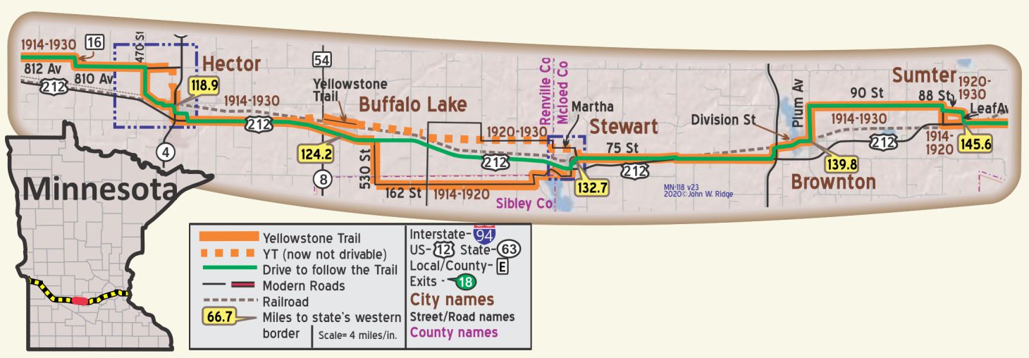 MN-118.9 Hector
pop. 900; a farming community; rooms in homes. Hector Motor Co. leads, has wrecker. Good free camp in park. MH-1928*
(1,018 alt., 864 pop.), is in a region formerly known for excellent water-fowl shooting. While extensive drainage eliminated much of the game, Mongolian pheasants, recently introduced into the locality, are now quite numerous. A free Tourist Park. WPA-MN*
206 S Main St. is Rural American Bank, built in 1916. And the building is still recognizable as pure Prairie School.
US 212 E (Yellowstone Trail). Hill’s Unique Gifts. You’ve got to stop here. It is a delightful tourist trap. We mention it because it once had large, yellow Yellowstone Trail signs out front, but now they are somewhat muted. There are thousands of unique items you don’t need but would find kooky. See for yourself. Hill’s is the Yellowstone Trail’s answer to the kitsch of Highway 66.
November 6, 1919 Hector Mirror:
HECTOR BUSINESSMEN OPPOSE CHANGE IN ROUTE OF TRAIL
The Club Room of the Village Hall was crowded with citizens to discuss a matter it having been reported that the State Highway Commission was to change the route of the Yellowstone Trail. The Club voted unanimously against such a proposed change, and voted to pay Hector’s allotment for the upkeep of the Yellowstone Trail.
NOTE: A state highway commission does not “move the Yellowstone Trail;” it declares a different highway a state highway and it is up to the Yellowstone Trail Association to move its signs to the new, better highway. This threat seems to have jarred the group into paying their dues.
MN-124.2 Buffalo Lake
pop. 460; in a stock and grain-raising area. Rooms at Yellowstone Hotel; not modern. Frank’s Garage is best. Free camp, two blocks from Trail. MH-1928*
US 212 still is called Yellowstone Trail in Buffalo Lake. There is a senior housing complex at 703 W Yellowstone St. Many businesses are on it, but the old Yellowstone Trail Hotel, on that road and once the life blood of the village, is no more.
MN-132.7 Stewart
(1,063 alt. 541 Pop) on the eastern edge of a 50-mile undulating plain covered with rich glacial drift. West of the lakes scattered in the eastern part of this expanse, the horizon is broken by moraines. WPA-MN*
pop. 550; rest room at community hall; country hotel, small garage, free camp space. MH-1928*
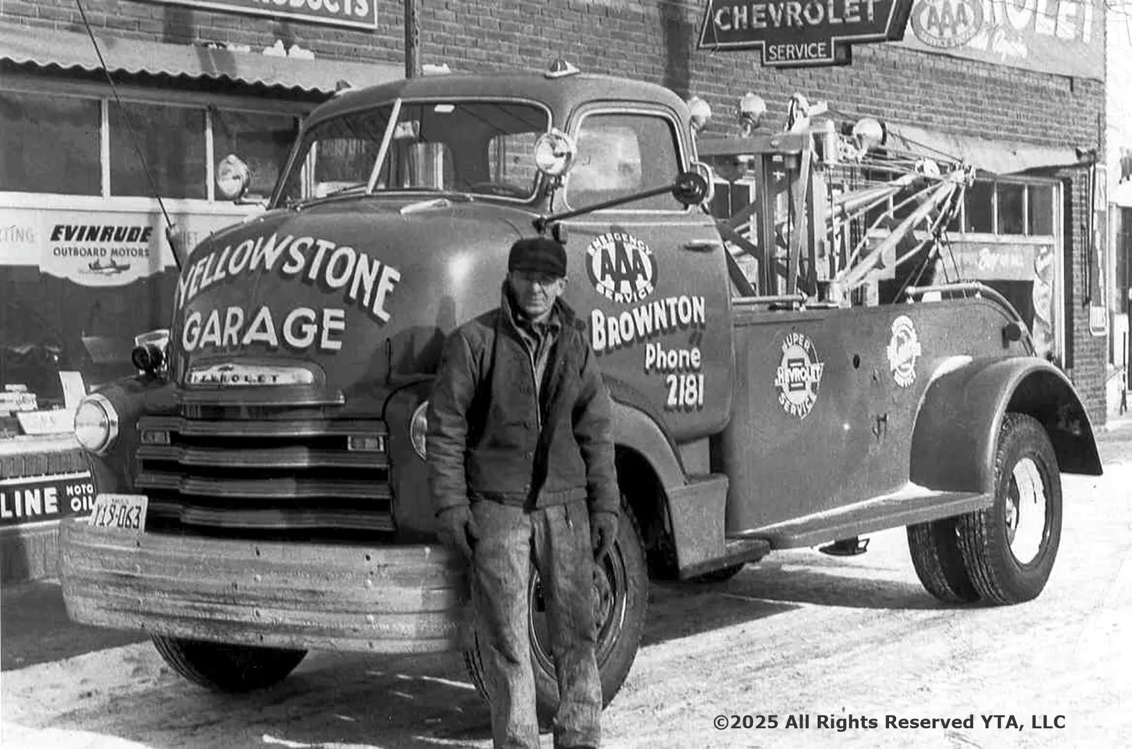
MN-139.8 Brownton
pop. 650; stock and grain raising supply principal revenue. Commercial Hotel is best, not modern. Yellowstone Trail Garage has best mechanics. Free camp space two blks. from trail. MH-1928*
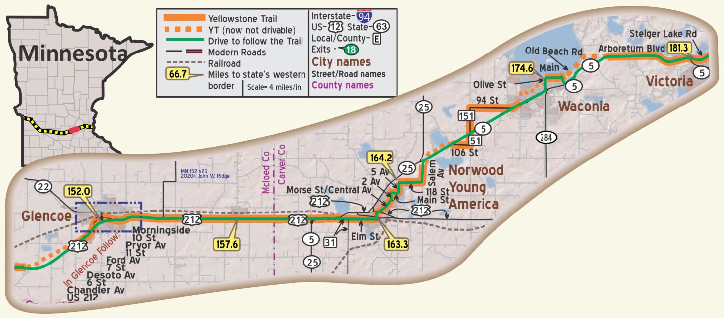 MN-152.0 Glencoe
pop. 1,750; an old and substantial town; a cattle-shipping point; best rooms in homes; Sweet Shop for lunch. Beneke Garage has good mechanic. Nice free camp in oak grove. MH-1928*
Glencoe was named for its resemblance to a valley in Scotland. City Hall, County Courthouse, and Carnegie Library all were built at the turn of the 20th century (thus probably seen by Yellowstone Trail travelers) and all are on the Register of Historic Places.
MN-163.2 Norwood Young America
Norwood pop. 550; a village; country hotel. Lunow’s Garage is reasonable and has skilled mech. Free camp space; no conveniences. The Grivelli house has rooms and serves excellent home-cooked meals, 60c. Good Buick garage. MH-1928*
Norwood Eastbound: Choose to either stay on the later YT, or, follow the earlier YT and go north from Norwood. Leave Highway No. 212 and follow the Yellowstone Trail Highway No. 5.
NOTE FROM MH-1928: No. 12 (today is 212) via Chaska has fewer turns and better surface but the Yellowstone Trail passes many beautiful lakes and is much prettier and a little shorter. MH-1928*
Norwood and Young America became one city on January 1, 1997.
Elm and Hazel Sts. (Elm is the Yellowstone Trail.) Winter Saloon. GPS: 44.76791, -93.929036. A c.1890 saloon with attached living quarters, Norwood’s oldest and best preserved drinking establishment and a prominent feature of its downtown. In the 1890s the second floor was used by fraternal organizations. It is also known as Harm’s bar since it was in the Harm family for three generations. The price of a liquor license in 1891 was $2.08, $1,500 in 1954. On the National Register of Historic Places.
224 Hill St. Norwood Methodist Episcopal Church. GPS: 44.76793, -93.92818. Built 1876, this small, architecturally interesting church looks freshly painted white with red trim. It appears to be in active use, cared for, and welcoming.
MN-174.6 Waconia
pop. 1,000; a pretty little town on Lake Clearwater. This famed lake, together with Paradise Isle, is one of the outstanding beauty spots of Minn. Boating and fishing at its best. Hotel North Star has clean rooms, not modern. Menzel Garage is good and has wrecker. MH-1928*
The 1928 Mohawk-Hobbs Guide is interesting because it calls the lake “Lake Clearwater” when it seems that it was always called Lake Waconia, and, although the name of the island in the lake was called “Paradise Island” in 1927 and 1928, that name lasted only for a brief time and reverted back to “Coney Island.”
Yellowstone Trail travelers, no doubt, stopped to see Lake Waconia 100 years ago just as you can see the lake, beach and park today. Coney Island Resort, formerly a drawing card to its famous Coney Island, is now gone. At present, Carver County is working to eventually return the island to a recreational and historical site.
9 W. First St. Waconia City Hall, a red brick civic building designed in 1909 to accommodate city offices, fire station, library, senior center and public hall. It is noted for its locally unique architecture.
555 W 1st St. Carver County Historical Society Museum. This museum is on the move and they know about the Yellowstone Trail. Much preservation work occurs, along with activities in the museum itself. It’s a jumpin’ group. Ask for directions to the Andrew Peterson historic orchard farm which the Society owns.
48 W. Main St. (Yellowstone Trail). Mock Cigar Factory and House, nicely painted green and white. It was a false-front factory and attached Italianate house (c.1875) owned by E. H. Mock, proprietor of an early Waconia industry, and is on the Register of Historic Places because the property is associated with important American history events.
MN-181.3 Victoria
The City of Victoria is known as the “City of Lakes and Parks.” It is surrounded by lakes and borders the University of Minnesota Landscape Arboretum and Three Rivers Park District’s Carver Park Reserve.
Just east of Victoria, watch for the jog between Steiger Lake Rd. and 78 St. along MN 5. Traveling from the west the turn to the north to Steiger Lake Rd. is hard to see. It is just east of the Dairy Queen! For several blocks in the middle of Victoria the original YT cannot be followed, but now Steiger Lake Rd. can be followed. However, west bound travelers will need to work around a few blocks of one-way streets.
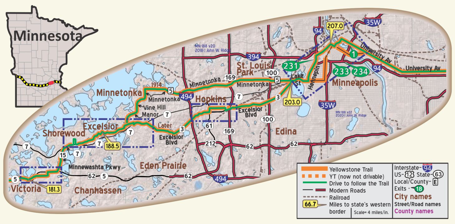 MN-187 Shorewood
Today there is still a street named “Yellowstone Trail” running on the original alignment through Shorewood.
Yellowstone Press is located on this winding, hilly street amid an area of lovely homes. The western end of this section requires a detour because of the modern intersection with MN 7.
MN-188.5 Excelsior
305 Water St. Excelsior/Lake Minnetonka Historical Society Museum. Turn off of MN 7 at County MN 19 then right at Water St. “The hub of all activity in this quaint little town,” said a reviewer.
The Society runs the 1906 (restored) Steamboat Minnehaha on Lake Minnetonka tours.
The Society’s mission is “to preserve, document, and classify the physical history of the Lake Minnetonka area.”
37 Water St. The Museum of Lake Minnetonka is an all-volunteer organization that maintains and operates the 1906 Lake Minnetonka “streetcar” steamboat, Minnehaha. Take a ride. You will hear about the place in history the Minnehaha held in the early 1900s as you travel from Excelsior to Wayzata. The steamboats were not converted streetcars; they were constructed and painted to look like one as they transported vacationers to their lake cottages. After 1921 automobiles and better roads did the job. Four steamships were eventually scuttled, including the Minnehaha, and three were scrapped. Raised in 1980, the Minnehaha sat for 10 years before being totally restored and returned to service in 1996.
The Excelsior Streetcar Line near US 7. The Line’s station is between 3rd and George Sts. The electric trolleys reached Excelsior in 1905 after regular railroads such as the Milwaukee Road and the Great Northern ceased running tourists to resorts west of Minneapolis. Those trolleys were running when Yellowstone Trail travelers toured the area. Board at the Water St. stop between 3rd and George St. or at Old Excelsior Blvd. near Minnetonka Blvd. Reservations are not required. Cars are restored historical artifacts more than 100 years old. “We do not operate them in the rain. Occasional mechanical problems may force us to alter or cancel our schedule,” they say.
MN-197.1 Hopkins
pop. 4,000; a factory suburb of Minneapolis. Sustained largely by the Minneapolis Threshing Machine Co. which employs nearly 1,000 men. Hopkins Motor Co., Ford, is good on all cars. Free camp at Fair Grounds. MH1928*
703 Excelsior Ave. (the 1921 Yellowstone Trail) Yellowstone Trail Garage. Now site of Hopkins Honda Collision Center.
907 Main St. (earlier Yellowstone Trail) Hopkins Historical Society. A resource center of over 10,000 photos and other collections depicting the history of Hopkins and area.
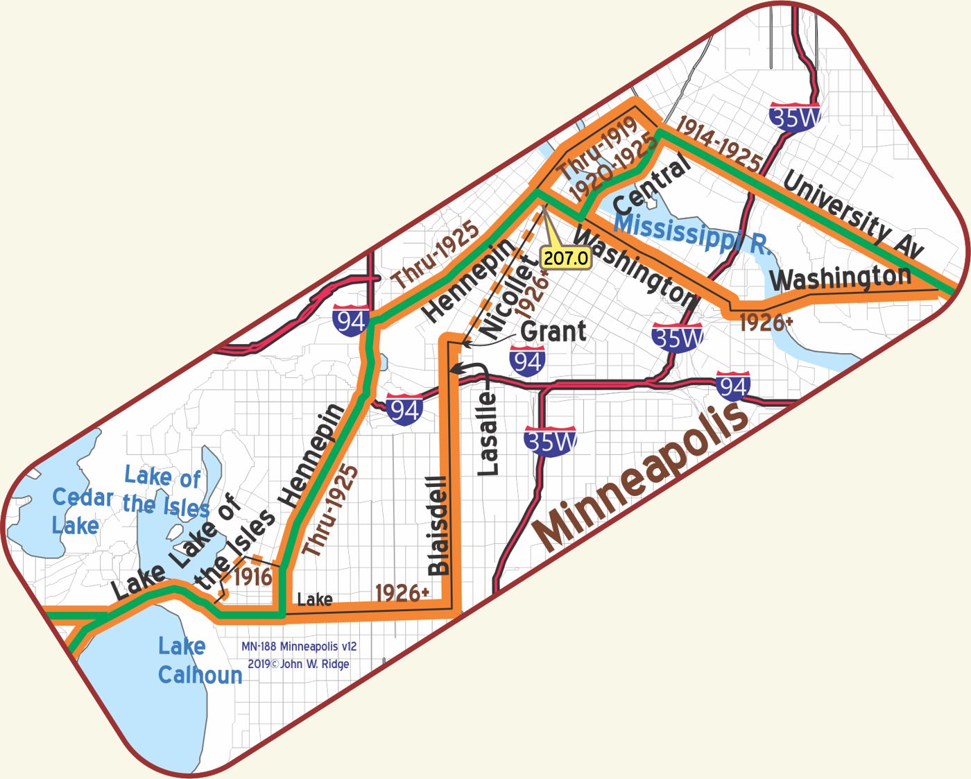 MN-207.0 Minneapolis
Minneapolis, situated on both sides of the Mississippi River, is one of the most beautiful cities in America. Its wonderful lakes, splendid boulevards and many parks are most enjoyable. A trip through the huge flour mills is very interesting. The high-class Auto Club is at 13th and LaSalle Ave. Municipal Tourist Camp, 50c, at Minnehaha Park, on Miss. River (southeast part of city). MH-1928*
HOTEL RADISSON well managed and high class.
Large and luxurious rooms; outside ones best. Sgl. $2-$6.50; dbl. with toilet $4-$5; with bath $5-$10.
CURTIS HOTEL the largest and one of the best liked in the Northwest. All rooms with bath; all rooms light. Sgl. $2-$3; dbl. $3-$4; twin beds $4.50-$6. Lunch 60c; dinner $1.MH-1928*
Since the Trail flowed right through downtown Minneapolis, many 100-year-old “skyscrapers” are visible there. Those sites described below surely would have been visited by the Trail’s travelers.
500 Nicolet Ave. The Andrus Building. Main office of the Yellowstone Trail Association from 1918-1923. From 1924-1926 the office was at 816 2nd Ave. S and finally from 1927-1929 it was at the “Evanston Building.” From these offices flowed hundreds of thousands of maps, weather reports, newsletters, research statistics and letters to individuals. Unfortunately, only a few original pieces of information remain. The organization ceased operation in 1930. Most official records and all undistributed publications were lost when the office was closed.
821 Marquette Ave. Foshay Tower. Set well back from the street and closer to 9th St. is a 1929 “skyscraper,” its 32 floors with the name FOSHAY emblazoned on the top are still easily visible today. Built to resemble the shape of the Washington Monument, it was finished just in time for the 1929 Stock Market crash. Story has it that some businessmen jumped from the tower at the prospect of financial ruin. Today it serves as a 4.5 star hotel called W. Minneapolis -The Foshay Tower. Do see the museum on the 30th floor.
704 S 2nd St. Mill City Museum is a Minnesota Historical Society museum and a “must see.” It opened in 2003 built in the ruins of the Washburn “A” Mill next to Mill Ruins Park on the banks of the Mississippi River. Every working day, approximately 175 railroad cars of wheat were processed at the Washburn “A” Mill during its heyday. The area’s historic milling district used the power of falling water at St. Anthony Falls. Flour milling boomed and numerous mills along this stretch of river changed the way food was produced, marketed, and distributed.
The Mill City Museum focuses on the founding and growth of Minneapolis, especially flour milling and the other industries that used water power from St. Anthony Falls. The mill complex, dating from the 1870s, is part of the St. Anthony Falls Historic District. We include this site because of its powerful story-telling displays of the history of the Twin Cities.
You can see the Stone Arch Bridge and St. Anthony Falls from the roof. GPS: 44.97870, -93.25750.
1 Portland Ave. St. Anthony Falls Visitor Center and Lock and Dam.
St. Anthony Falls figured largely in early Trail literature. Exhibits at the visitor center provide information about the falls and its place in Minnesota history.
100 Portland Ave. Stone Arch Bridge. Built by railroad baron James J. Hill in 1883, the bridge allowed for increased movement of people and goods across the Mississippi River. It served as a working railroad bridge until 1978, but is still seen as a symbol of the railroad age.
201 3rd Ave. S (Yellowstone Trail). Chicago, Milwaukee, St. Paul and Pacific (The Milwaukee Road) Minneapolis’ oldest surviving railway station, built 1897–9, with an earlier 1879 freight house. They are also significant for their architecture and association with the milling district. Now a commercial complex known as The Depot.
Before you leave Minneapolis, relax and spend a little time driving around the city’s many lakes. Find peace and solitude from this otherwise urban environment. After all, Minnesota has 10,000 lakes and some are right here. Lake Nokomis, Cedar Lake, Lake of the Isles, Lake Harriet, Lake Calhoun, (now called Bde Maka Ska) all have their eponymous parkways, bicycle, and walking lanes.
Find Minnehaha Parkway on the southside to reach Minnehaha Falls, Minnehaha Park, Longfellow Gardens and a replica of Henry Wadsworth Longfellow’s home in Massachusetts. Minnehaha Falls was a big attraction in Trail days. The 1917 Automobile Blue Book describes the Falls as “unrivaled for picturesque beauty. No cascade has ever been so celebrated in song and story and none claims a surer charm for the visitor.” Near the Falls you will see a bronze statue of Hiawatha and his love, Minnehaha, placed there in 1912. Also nearby is Lake Hiawatha.
Longfellow’s epic (22 chapters) poem, The Song of Hiawatha, is a fictitious and tragic love story of two Indians set on the southern shore of Lake Superior, but many claim that this falls was mentioned in the poem. Minneapolis and the Cult of Hiawatha, found in Historyopolis.com, says, “Minneapolis claimed the verse as its own, even though it was set ‘on the shores of Gitchee Gumee.’ The urban landscape was reshaped by the poem’s iconography. Minnehaha Park was christened in 1889; Lake Amelia became Lake Nokomis in 1910; Rice Lake was reborn as Lake Hiawatha in 1925.
NOTE– The 1914 First Year Book shows that the route of the YT from the west ends at the train station just south of the Capital in St. Paul. The case is that here, as in most other places, the route during 1912 and 1913 was not well documented.
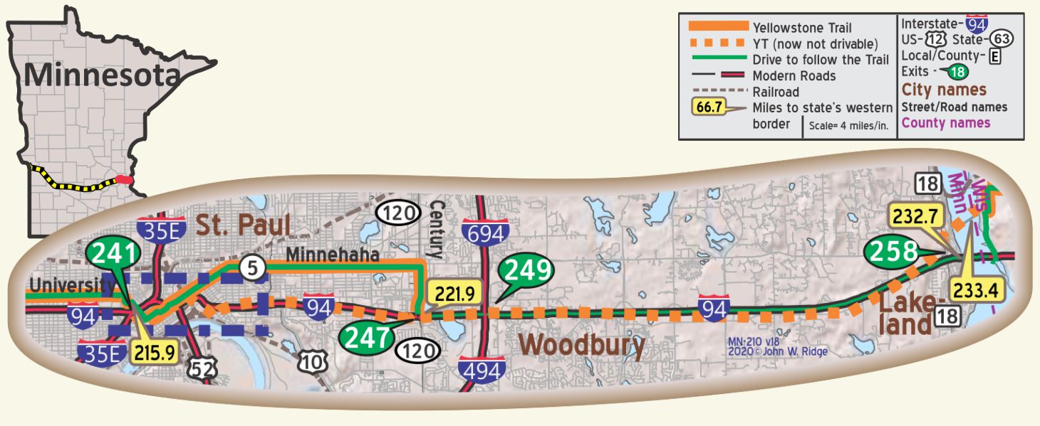 MN-215.9 Saint Paul
population over 300,000; is located on terraces running back from the Miss. River. It is the capital of the state, the oldest city in the Northwest and is a very important industrial and distributing center. The Ford plant covers 186 acres. Visit the magnificent State Capitol, Cathedral of St. Paul, Como Park and the noted city market. The Auto Club is at 4th St. and Smith Ave. Alverdes Restaurant is good, lunch 65c, dinner $1. St. Paul City Camp, in beautiful Cherokee Park, overlooking the Mississippi, 50¢. MN-WPA*
SAINT PAUL HOTEL is finest. Has air of distinction. Splendid large lobby. Sgl., $3-$3.50; dbl. $4-$8; suites up to $15; all baths. Unexcelled dining; lunch 60¢-$l; dinner $1.50; coffee shop. MH-1928*
350 Market St. St. Paul Hotel. From 1910 until today, the St. Paul Hotel has been regarded as one of the nation’s premier hotels. The famous, from Charles Lindbergh to John F. Kennedy, have stayed there. It displays century-old charm and decor along with the modern.
The St. Paul Grill has a startling display of beverage bottles in the bar.
200 Tower Ave. Fort Snelling, originally known as Fort Saint Anthony, was a military fortification located high on a bluff at the confluence of Minnesota and Mississippi Rivers. Built in 1819 to ward off any Canadian or British invaders, the Fort stayed active until 1946. The Fort is a National Historic Landmark. During the summer, costumed personnel interpret life at this early post. GPS 44.89360, -93.18690.
193 Pennsylvania Ave. E. The Minnesota Transportation Museum. In the 1907 Jackson Street Roundhouse, is a fully functional railroad roundhouse, one of the last of its kind in the country. It is highly interactive, offering train rides and hands-on exhibits about surface transportation history of Minnesota. This site has been used for rail transportation since the first railroad came to Minnesota in the 1860s.
75 Rev. Dr. Martin Luther King Jr. Blvd. The Minnesota State Capitol. (The Yellowstone Trail ran along the west side of the capitol building.) The 1905 domed capitol building, the third and final building for the capital city, features a large, gilded statue of four horses in front of the main entrance. They represent the power of nature: earth, wind, fire, and water.
10 E Exchange St. Fitzgerald Theater (that’s F. Scott Fitzgerald). The Fitzgerald Theater is the oldest active theater in Saint Paul. Built in 1910, it gets rave reviews for “not a bad seat in the house.”
214 Fourth St. E. Union Depot. Begun in 1917 and completed in 1923 (World War I intervened), this station replaced the original 1881 structure which saw as many as 150 trains a day. In 1971, the station saw the last of railways and stood idle. In 2005, the Ramsey County Regional Railroad Authority renovated the station as an intermodal transit hub served by Amtrak trains, Metro Transit light rail, and intercity bus lines. Since its renovation in 2012, the place has hosted special events. Go look at the marvelous space.
240 Summit Ave. James J. Hill House. The rugged stone, massive scale, and ingenious mechanical systems of this magnificent Gilded Age mansion recall the powerful presence of James J. Hill, builder of the Great Northern Railway. The 1891 house has13 bathrooms, 22 fireplaces, 16 chandeliers, a reception hall nearly 100 feet long, and a two-story, skylit art gallery. It was once the largest private residence in the state.
GPS: 44.94540, -93.10930. Pause and enjoy all of the neighborhood. Many old, large historic houses call Summit Ave. home.