
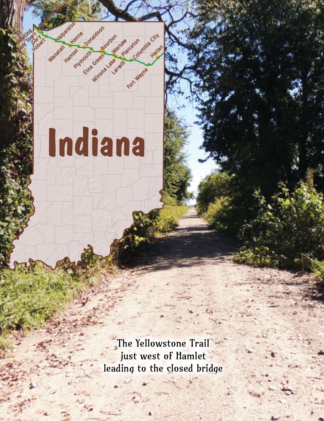

 The map’s green circle markers
are modern highway exit numbers
used for current location reference.
 The map’s yellow rectangle mile markers show path of YT and distance to state’s west border. Click the corresponding number in text for directions and more information.
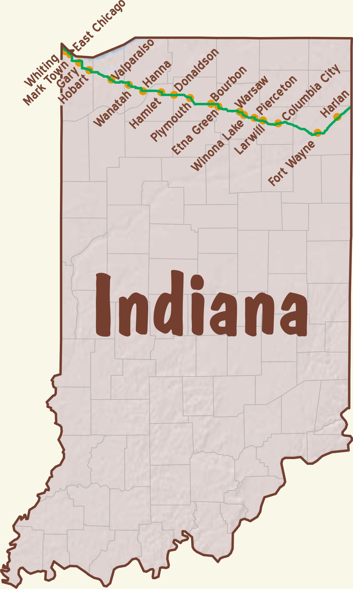
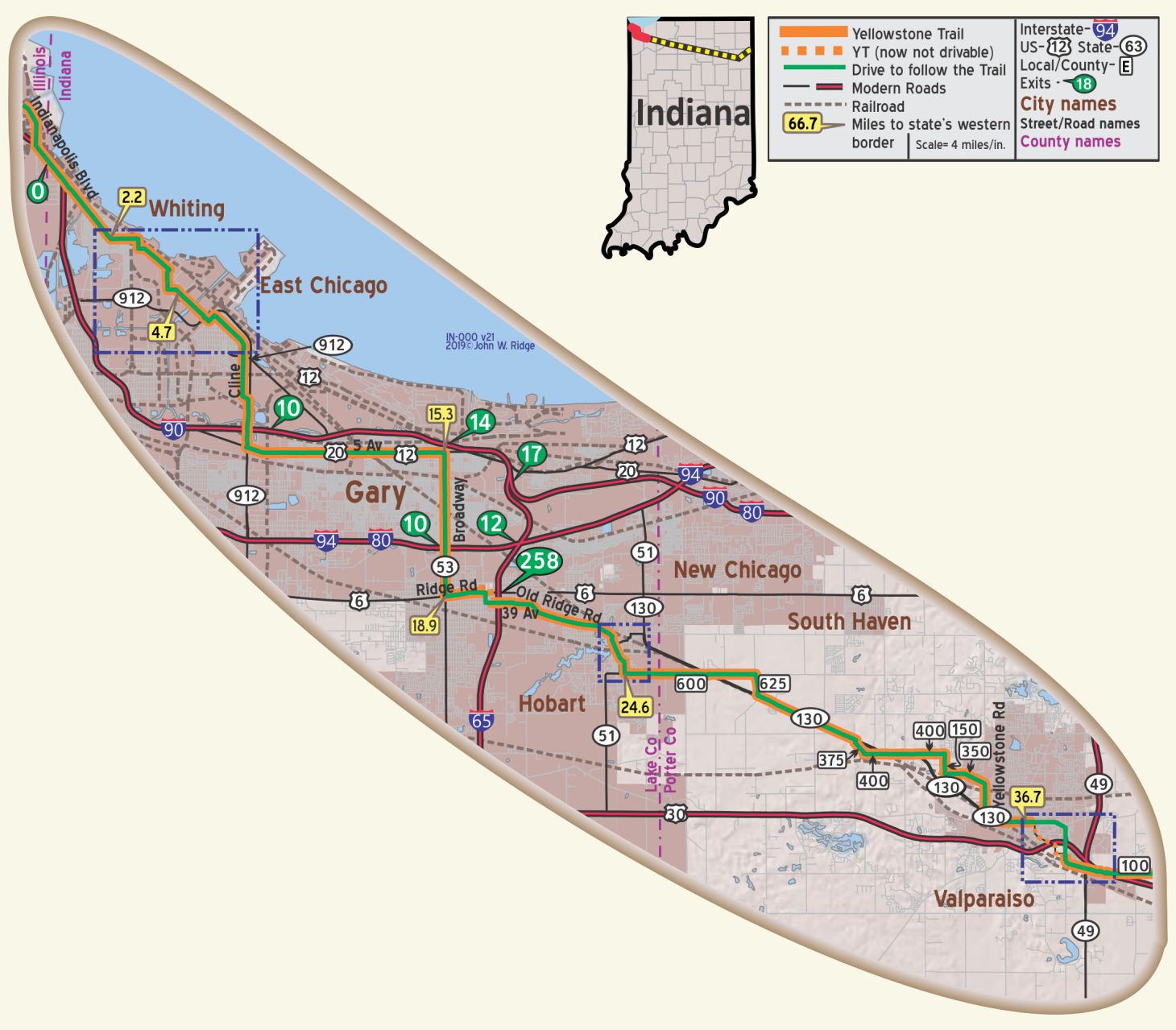 For Directions, click the Indiana YTA Mile Marker Numbers (below) linking you to a real-time map.
IN-000.0 Illinois/Indiana Line
IN-002.1 Whiting
In 1923, Standard Oil Company refinery employed over 4,000 workers. WPA-IN*
Note that the Yellowstone Trail follows Standard Ave. (named for Standard Oil), the historic route close to refineries on both sides.
1610 119th St. Whiting-Robertsdale Historical Society has articles of local importance.
At the intersection of Indianapolis and 119th avoid Cleveland.
IN-004.2: This area is heavily industrialized and roads have been and are being reshuffled to meet modern needs. You may have to explore a bit to find your way. The original YT may have more closely followed Dickey St.
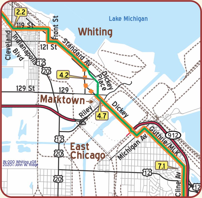 IN-004.7 Marktown
For the heritage traveler, Marktown is a very unusual and serendipitous find. It is part of East Chicago, not a separately incorporated city, but it is isolated within a massive industrial plain.
Starting in 1917 the Marktown Site was built by Clayton Mark Sr. to be used as housing for his Mark Manufacturing (steel) Company employees. It was to include housing for 8,000 workers and all conveniences of a model village on 20 acres. In 1923, Mark sold his company with only a fraction (200 houses) of the community built.
Restoration and preservation are not thriving. Some of the 1917 houses are still standing today, but many are in decay. Surrounded by busy highways and petroleum smells and derelict steel mills, apparently fewer want to live there.
Check the Marktown website for information and tours.
IN-006.0 East Chicago
East Chicago with its port at Indiana Harbor became one of the great shipping centers of the Nation. The most important industry to enter the region was steel. Inland Steel had established a plant in East Chicago in 1893; and when US Steel Corporation decided in 1905 to erect its greatest mills on the sand dunes, the industrial future of the region was assured. WPA-IN*
Here was the world’s largest cement plant. East Chicago (western section) is separated from the Indiana Harbor section by a vast rail yard that served as the rail gateway to Chicago and the west. A canal system of waterways joins the Calumet River to Lake Michigan.
2401 E Columbus Dr. East Chicago Historical Society has useful information about this complex area.
NOTE: IN-7.8: Cline St. and IN 912 south of East Chicago run parallel. Today’s driver must switch from one to the other of those two roads by using one of the exits, probably 7.
NOTE: IN-15.1: The YT followed 5th Ave. which is now one-way so 4th Ave. may be needed to be used.
IN-015.3 Gary
Gary came into being when massive mills were built along miles of lakefront and tens of thousands of workers were brought in. With US Steel firmly entrenched as a magnet, other enterprises were drawn to the region. WPA-IN*
220 W 5th Ave. Gary Historical & Cultural Society on US 20. They preserved Gary’s first building – The Gary Land Company Building (1906) – and maintained it as an historical museum. Population, at this writing, has shrunk more than 50% of its former size with devastation visible along the Trail.
NOTE: IN-20.1: Just west of I-65 the YT followed Missouri St. between what are now known as Ridge Rd. and 39th Ave. (was Old Ridge Rd.) Missouri St. is now partially overrun by an I-65 interchange. The existing parallel streets are poorly marked. Tennessee or Louisiana Sts. may be used today.
IN-023.1 Hobart
Hobart morphed from a major railroad and shipping hub in the late 1800s to a residential community for employees of area industries from the 1920s. Street railway service to Gary began in 1914, just before the Yellowstone Trail arrived.
Hobart is uncovering history by restoring the original facades, original brickwork and authentic architecture of downtown buildings.
The historic district holds some preserved buildings which were on the Yellowstone Trail.
Included are:
the First State Bank built 1888 (301 Main St.);
the Friedrich Building built 1910 (614 E Third St.);
and a neat First Unitarian church on Main St. built in 1874.
Deep River County Park is a beautiful, serene park featuring Wood’s Historic Grist Mill, built in 1838 by John Wood and rebuilt in 1876 by his son, Nathan.
706 E 4th St. Hobart Historical Society Museum contains local artifacts.
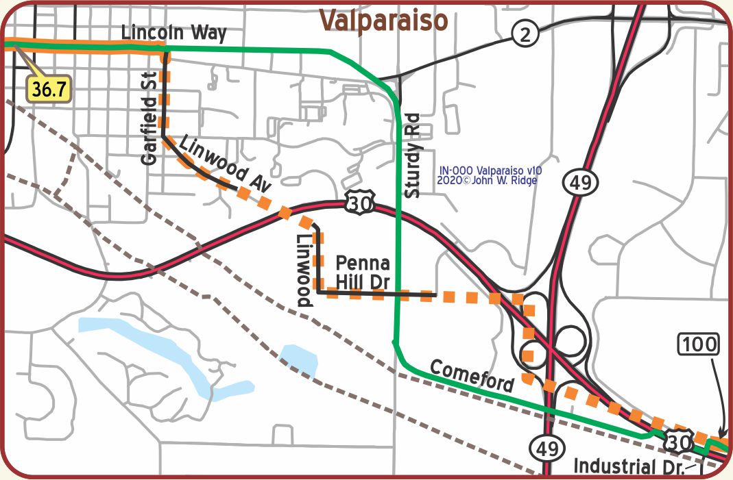 IN-036.7 Valparaiso
Under Henry Brown’s excellent management Valparaiso University became nationally known as the “poor man’s Harvard,” and in 1914-15 boasted a student body of 6,000, second only in size to that of the older Eastern university. WPA-IN*
The Indiana Steel Company Plant (visitors welcome), in the northwestern part of town, produces 80 per cent of all the magnets made in the United States. WPA-IN*
The Yellowstone Trail and the later routing of the Lincoln Highway run together for a short distance in Valparaiso. Author Michael Buettner says,
It is probably safe to assume that with the completion of the original US Route 30 alignment between Valparaiso and Fort Wayne, the Yellowstone Trail immediately relocated to match the federal route. The Lincoln Highway would make it a triumvirate of routes after its relocation in 1928. As a result, this is the only region in the United States where the two groundbreaking automobile trails shared a common corridor.”
The route of the Yellowstone Trail from Valparaiso to Fort Wayne looks like a series of “stair steps” along section lines.
Glaciation has left numerous kettle lakes and knobs in this hilly area of northwest Indiana. Many glacial erratic can be found throughout the city.
The downtown square contains several historic buildings, preserved from the 1800s and on the National Register of Historic Places around, roughly, today’s Lincolnway (the Yellowstone Trail) and Franklin St.
The Porter County Museum of History is one block from Lincolnway (the Yellowstone Trail), next door to the Memorial Opera House, on Indiana Ave. near Franklin. Housed there since 1916, the museum has an eclectic collection ranging from local historic tools to a World War II P-38 tough can opener, dubbed the “John Wayne.” Also contained are Dr. Noah Amstutz’ inventions which led to the cathode ray tube and TV. The rear of the building is an old jail.
Next door, 104 E Indiana Ave., is the restored 1893 Memorial Opera House, now called Memorial Hall. It featured John Philip Sousa at the turn of the century and the Marx Brothers in 1919.
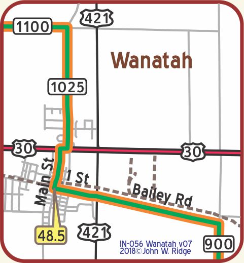
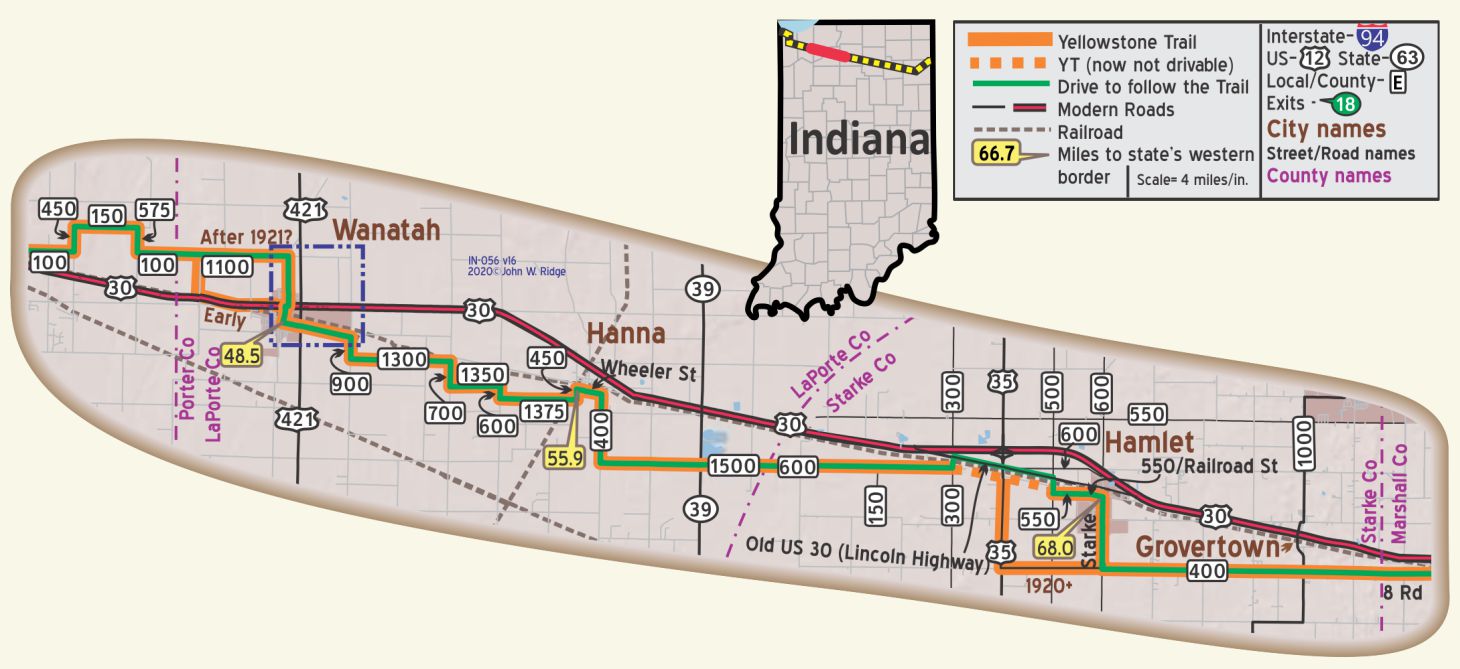 IN-048.5 Wanatah
Wanatah is a farming village named for Wa-na-tah, an Indian chief who is said to have been noted for his laziness. WPA-IN*
Keep an eye out for Yellowstone Trail markers on the well marked Trail in Wanatah.
West Cross St. (one block west of the Yellowstone Trail). Wanatah Historical Society. An active group, they promote awareness of the area’s rich history. They have a fully restored 1888 wooden caboose filled with railroad memorabilia from more than fifteen different railroads.
IN-068.0 Hamlet
HAMLET, (702 alt., 519 pop.), was platted in 1863 by John Hamlet. It owes its existence to its location at the crossing of the Pennsylvania and New York Central Railroads, and is a shipping point for the surrounding country. WPA-IN*
4 W Davis St. Waymire’s Corner Tap around the corner from Starke St., the Yellowstone Trail. The building, built c.1915, housed the former Hamlet Café and Hotel, also called the Yellowstone Trail Hotel. The Hamlet Café was reputed to be a stop for Al Capone; John Dillinger was also seen on the Trail.
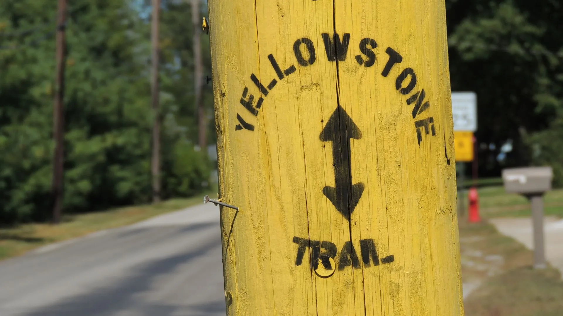
Keep an eye out here, too, for Yellowstone Trail signs. There was an interesting hand-painted Yellowstone Trail sign on a telephone pole at the corner of Indiana and Starke Sts.
Hamlet is quite interested in the Trail, having hosted several annual “Yellowstone Trail Fests.” Everyone turns out for the themed activities involving their portion of the Trail, including old car runs, foot races on the Trail and scrap metal sculpture.
The Lincoln Highway is marked north of the tracks at N300E and N500E. It is Old US 30, which was the Lincoln Highway. It provides a good detour for the closed Trail.
NOTE: Near Hamlet, between N400E (US 35) and N300E, the YT has long been abandoned leaving a bridge over Robbins Creek (GPS: 41.38943, -86.63514). The bridge, still standing, is described at https://www.bridgehunter.com/bridge/73331.
Between US 35 and N500E the road is still formally known as the Yellowstone Trail and is driveable gravel but the intersection with US 35 may prove difficult. The signs that stood here and reflected the fate of the YT are now removed. They read: “Yellowstone Trail, Bridge Out, Dead End, Road Closed.”
IN-076.7 Donaldson
There is another hand-painted Yellowstone Trail sign here on 8th St.
NOTE: The YT follows a zigzag route across the tracks.
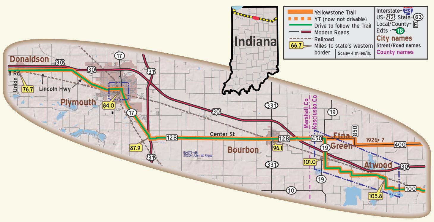
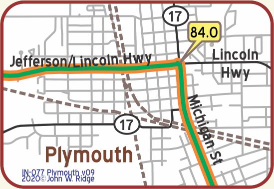
IN-084.0 Plymouth
(pop. 3,838, alt. 790 ft.), is a thriving town at the junction of three railroads. It has extensive manufactures of basket and box works and has beautiful streets and residences. At Twin Lakes, 3 miles southwest, is Pottawatomie Park, named for the Native American tribe who once inhabited this section. BB1921-4*
The Yellowstone Trail runs along the tracks from Jefferson to Laporte and on Laporte between the tracks and Michigan. BB1924*
NOTE: Plymouth sits at the intersection of five early routes, each celebrated in the Marshall County Museum.
123 N Michigan St. (Yellowstone Trail). Marshall County Museum. This vibrant museum really jumps. In addition to county and city memorabilia, interactive displays and guest expert presenters, they have a Transportation Center room. Five highways crossed Marshall County, the Yellowstone Trail being one of them. The history of those roads is told with audio stories, and the “Train Room” is a big draw, especially among the “train guys” who add to the moving display and manage it. Can one ever take the kid out of the man?
The Michigan Street Bridge across the Yellow River (one of 5 notable bridges) carried the Yellowstone Trail in downtown Plymouth. A blog entitled “Hoosier Happenings” described the bridge, saying that the Michigan St. concrete bridge was built in 1916-17 and that “ It was constructed in place of the early metal Michigan Road bridge, probably in keeping with the construction of the Yellowstone Trail following the alignment and bringing additional vehicular traffic across the bridge.”
NOTE: IN-087.9: The intersections of US 31 with Co 12B and with Michigan Rd. are inadequately marked. Use care.
IN-096.1 Bourbon
(840 alt., 1,145 pop) active farm trading village. There is a Monument to the Old Town Pump. In the heart of the town, this colored rock monument, topped with a stone likeness of the old pump, replaces with a fountain the original supply of drinking water. WPA-IN*
Bourbonites are very proud of the memorial to the town pump that now is located in Sit Park on the corner of Old US 30 and Main St.
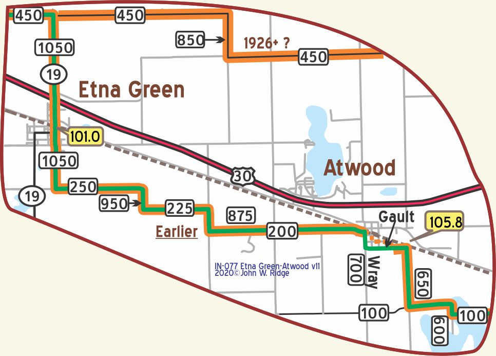 IN-101.0 Etna Green
The right angle turns taken by the Yellowstone Trail in the area are good examples of the effects of rectangular surveys.
IN-105.8 Atwood
NOTE: Several streets in Atwood are no longer driveable. Use Gault (east/west) and Wray (N200W) (north/south). The YT apparently followed (from the west) W200N past Wray, south on Harrison, east on High, south on Green, east on Gault to N650W. Note the curve between Green and High, an indication that it was used as a highway. These streets not labeled on this map.
NOTE: IN-105.8 – IN-113.8: One source, the 1926 Rand McNally map, shows the YT running north of Atwood and east of Etna Green. on what became US 30. Had the Trail been rerouted there?
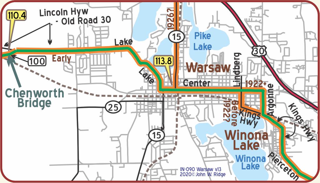
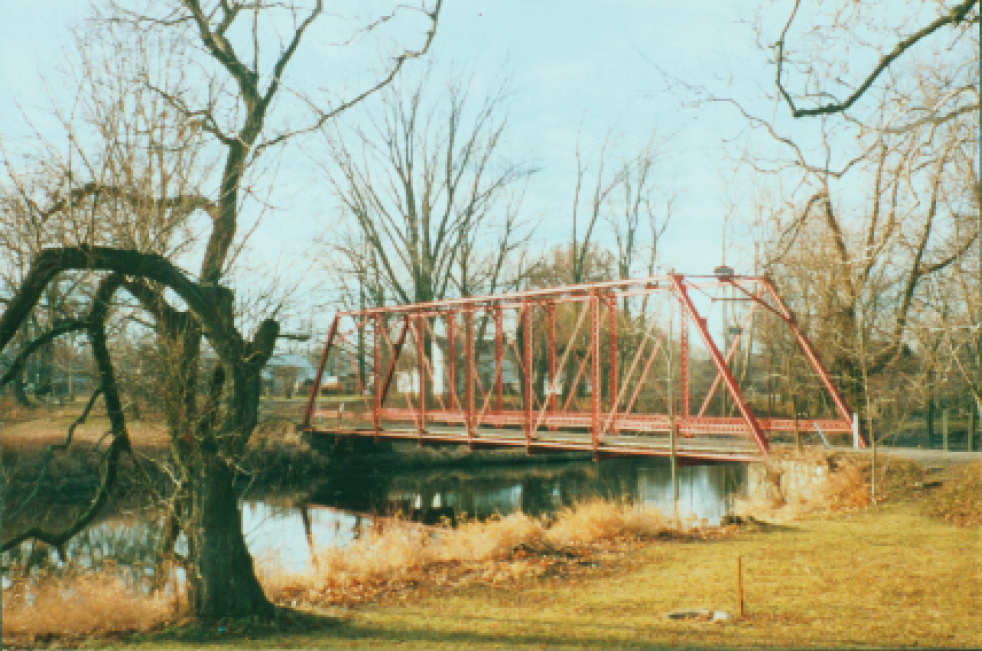 IN-110.3 Chinworth Bridge
The Chinworth Bridge crosses the Tippecanoe River between the old Yellowstone Trail and the 1928 Lincoln Highway, now called Old Highway 30. At almost 125 years old, the bridge now carries no vehicles, but hosts families out for a walk or just communing with nature. As it is near the site of the Chinworth Bridge Trailhead, it is also an inviting site for canoeists, picnicers and hikers at the nearby Tippecanoe Rest Park. The Kosciusko County Historical Society now owns the Park and leases the bridge.
The bridge is the last remaining Pratt through truss single-span bridge in the county, the kind once found throughout the country.
There once was a post with yellow bands and a “Y” in a black circle at the south end of the bridge marking the Yellowstone Trail, although neither the Yellowstone Trail nor the Lincoln Highway was routed over the bridge.
 The Chinworth Bridge (41.24697,-85.91077) connecting the YT and the 1928 version of the Lincoln Highway just west of Warsaw is described in BridgeHunter.com.
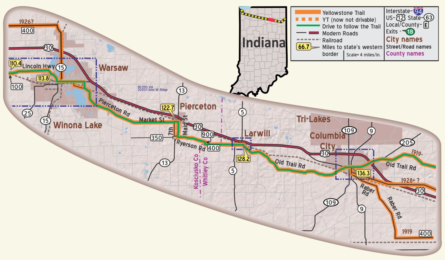
IN-113.8 Warsaw
(824 alt., 6,378 pop) the seat of Kosciusko County is in the heart of Indiana’s lake region. Two plants manufacturing surgical supplies are among the largest in the Nation and there are also cut glass and vacuum-cleaner factories. The northern part of town, now the finest residential district, was formerly a swamp that served as a rendezvous for horse thieves and counterfeiters. WPA-IN*
505 S Detroit St. Warsaw Cut Glass Company, Inc. In 1912 Warsaw Cut Glass opened for business. The building is constructed of rejected paving bricks from Warsaw’s street department. The long, narrow building features many high windows to allow as much natural light as possible (there were no electric lights). One main shaft drives two floors of cutting with 55 workers. The shaft, and the original leather belts, are in use today as one of the last American facilities practicing the art of cutting glass.
121 N. Indiana St. Kosciusko County Old Jail Museum. Located in downtown Warsaw, this Gothic Revival building was built in 1870. On the National Register of Historic Places, it currently serves as the headquarters for the Kosciusko County Historical Society. The Old Jail Museum & Genealogy Library are housed here. The sheriff and his family lived in the jail building and the sheriff’s wife provided the meals for the inmates.
IN-116.2 Winona Lake
Located around the eastern shore of Winona Lake, the Winona Lake Historic District includes various historic buildings that attest to the area’s history as a Chautauqua and Bible conference hotspot. “Chatauqua” was a New York organization that sponsored Christian speakers nation-wide. Famed preacher and professional baseball player Billy Sunday lived here; famous photographers taught here; The Winona Lake School of Theology was located here from 1920 to 1970. Today some restored original structures make it an historic summer resort.
100 9th St. Winona History Center in Westminster Hall of Grace College has pictures of early autos and Yellowstone Trail-era photos and more about Chatauqua and Winona’s significance.
IN-122.6 Pierceton
Many art studios and antique shops line IN 13, the Yellowstone Trail, in downtown Pierceton.
NOTE: The 7th St. route of the YT has an unknown date.
IN-128.2 Larwill

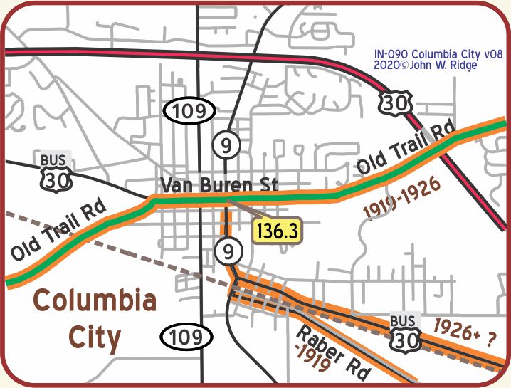
IN-136.3 Columbia City
108 W Jefferson St. Whitley County Historical Museum.
It is housed in the Columbia City home of Thomas Riley, Marshall, Indiana Governor and 28th Vice President of the U.S. under Woodrow Wilson.
The museum complex consists of the Marshall House, an Annex, and an outhouse.
Van Buran and Walnut Sts. There is an old operating gas station with original canopy.
Van Buren and Main Sts. Whitley County Courthouse. Van Buren Street was the Yellowstone Trail. The 1888 courthouse accorded travelers on the Yellowstone Trail a good look at its sculptures of animals and birds.
An historic district, bounded by Jefferson, Walnut, Ellsworth, and Wayne Sts., contains historic buildings, repurposed and thriving.
WAYSIDE – This Wayside is really worth the 27 mile drive north of Fort Wayne to Auburn. The most beautiful classic automobiles of all time are displayed on three floors of the 1974 Auburn Cord Deusenberg Auto Museum at 1600 S. Wayne St.
Over 100 antique autos are shown in the former Auburn Automobile Company building. These original Duesenberg, Cord, Auburn, Cadillac, and Rolls Royce beauties are so polished they hurt the eye. In 1926, Errett Cord, then the owner of Auburn Company, partnered with Duesenberg Corporation, famous for its racing cars, and used it for a line of high-priced luxury vehicles. He also put his own name on one of the first front-wheel-drive cars, the Cord L-29.
Wikipedia says “The Auburn Automobile Company administration building is part of the campus where cars were hand-assembled, rather than mass-produced. The showroom and administrative buildings were designed in Art Deco style.” The facility’s buildings were declared a National Historic Landmark in 2005. Because luxury cars were out of the question during the Great Depression, the company’s doors closed in 1937.
The Museum once served as the factory headquarters of the company beginning in 1930. It’s Art Deco decor is a fitting backdrop for these gorgeous cars. This is not a static museum. Each Labor Day weekend the autos are outside on parade – literally – which draws hundreds of spectators. Some exhibits have interactive kiosks that allow a visitor to hear the sounds the car makes and to see related videos.
Perhaps the best display of this Museum is a history of luxury cars and their need for good roads.
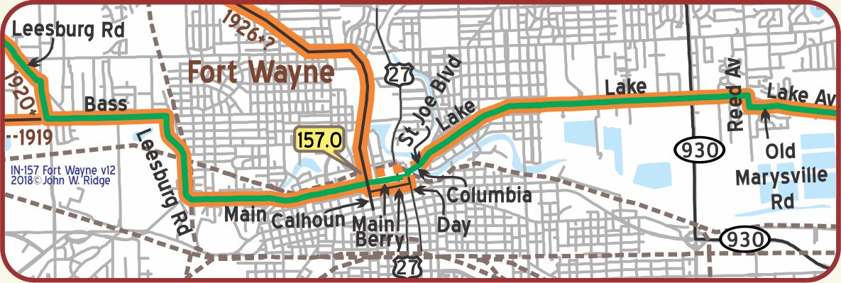
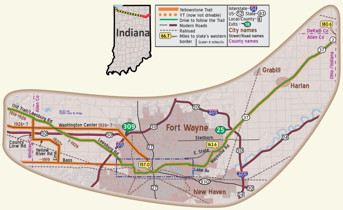 IN-157.0 Fort Wayne
Fort Wayne has interesting historic buildings.
Most prominent are four churches, all built in the mid-1800s.
Four Historic Landmarks are listed below:
The Pennsylvania Railroad Station, also known as Baker Street Station (1914)
2701 Spring St. University of Saint Francis, John H. Bass Mansion (1902)
216 E Washington Blvd. Masonic Temple (1926)
715 S Calhoun St. Allen County Courthouse (1902)
302 E Berry St. The History Center. Old castle-like 1893 building on the Yellowstone Trail. The Center also oversees the historic Barr Street Market (adjacent to the building), the oldest public space in Fort Wayne. Today the Center maintains a collection of more than 26,000 artifacts. The largest of these is the very building in which the society has resided since 1980-the 1893 City Hall building.