
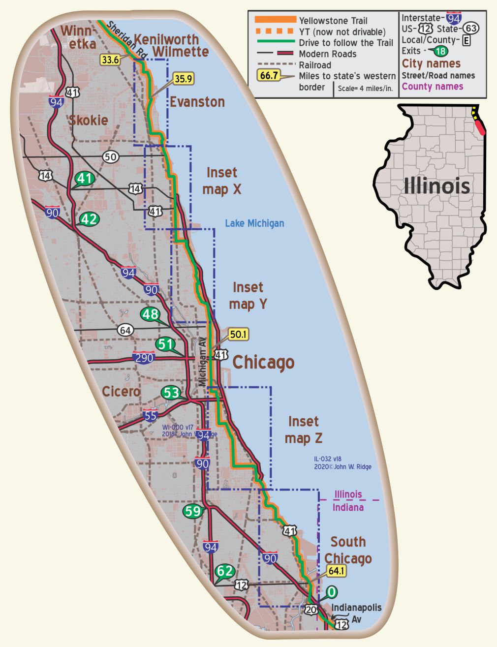
 The map’s green circle markers
are modern highway exit numbers
used for current location reference.
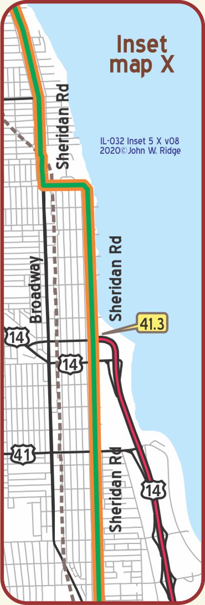
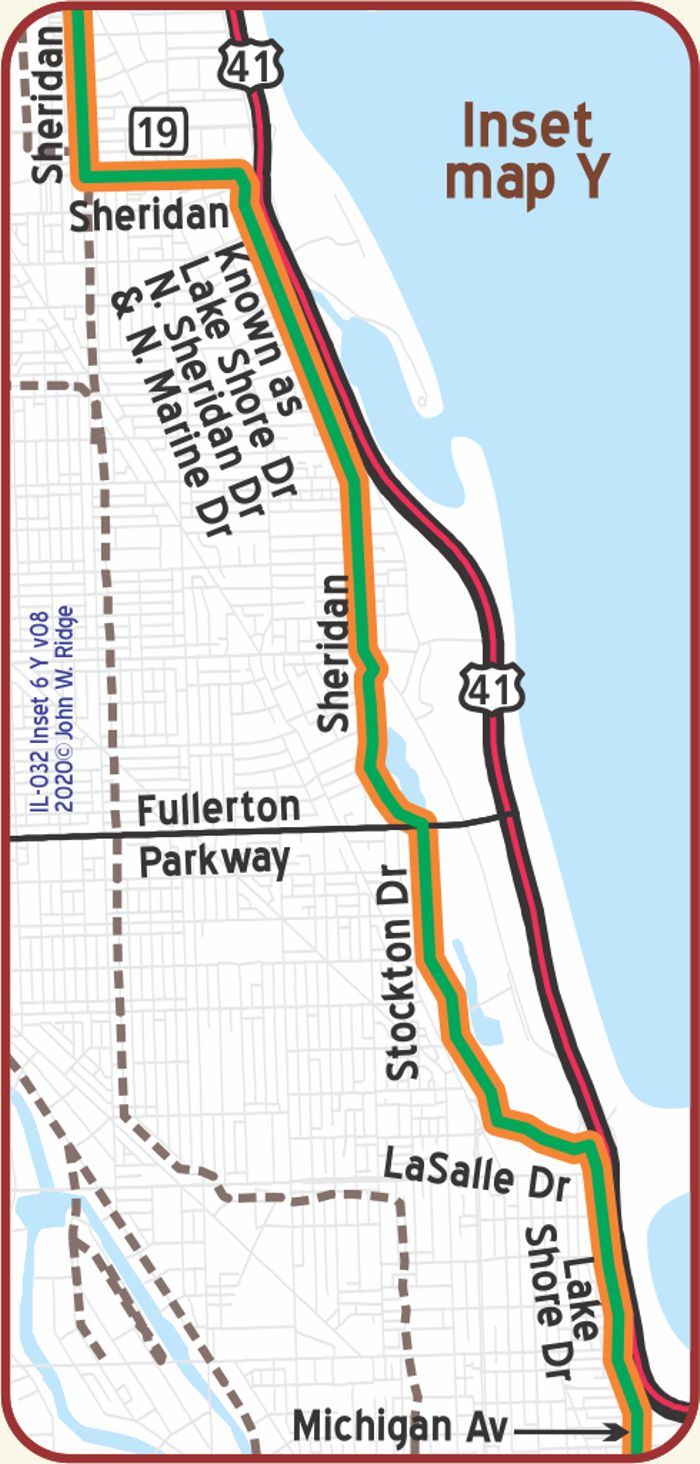
 The map’s yellow rectangle mile markers show path of YT and distance to state’s west border. Click the corresponding number in text for directions and more information.
 For Directions, click the Illinois YTA Mile Marker Numbers below linking you to a real-time map.
IL 000.0 Wisconsin/Illinois Line
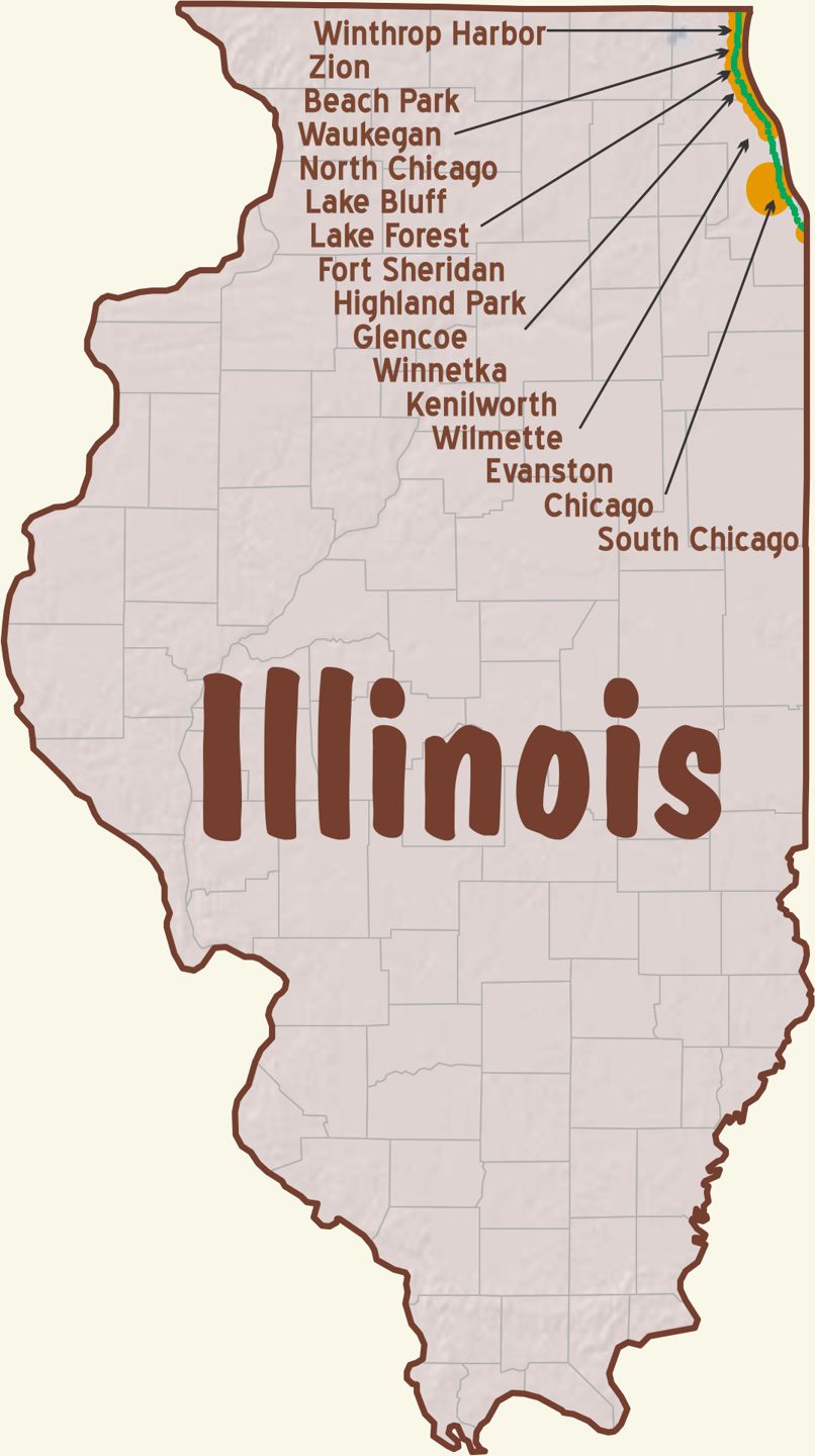
IL-000.9 Winthrop Harbor
is located midway between Waukegan and Kenosha, directly upon the famous Sheridan road. It has a splendid shore line and is surrounded by wooded plateaus, bluffs and picturesque ravines. Here, are located, among other industries, the Winthers Motor Co. and the Linga Carburetor Co. The town is served by the C. & N. W. and the C. & M. electric road. BB1921-10*
(598 alt, 661 pop.), grew out of the acquisition in 1892 of 2,700 acres of dairy farm land by the Winthrop Harbor and Dock Company, which planned to develop a harbor and establish an industrial town. With the collapse of the plan, dairying continued as the chief occupation of the community, and today its sole industrial plant is an ultra-modern dairy near the North Western station. WPA-IL*
IL-003.2 Zion
(pop. 5,000, alt. 938 ft.) is the seat of the singular religious community founded by John Alexander Dowie in 1900, 6,000 acres being purchased by him here at that time. The principal industrial feature of this town is the Zion lace manufactory, which was conceived and founded by Dowie, he being the first man to import a general line of lace machines and skilled lace weavers and designers from England into the United States. The industry was purchased by Marshall Field & Co., of Chicago, several years ago, and they have since greatly enlarged the plant until it is now the greatest and largest of its kind in the world. Zion City has three fine parks. Beulah park, one mile north of the city, on Sheridan road, is one of the most beautiful wooded ravines between Chicago and Milwaukee. BB1921-10*
(633 alt., 5,991 pop.) Zion was founded by a man who believed the world to be flat despite his having taken a trip around it. The town enforces one of the most stringent sets of blue laws in the country. WPA-IL*
In 1899 Chicago real estate offices were buzzing with rumors of a big land deal on the North Shore. On the night that marked the end of the nineteenth century, the man behind the deal revealed himself as John Alexander Dowie (1847-1907), Scottish faith-healer who, four years before, had founded the Christian Catholic Apostolic Church. He announced his plan for the city of Zion, a community where the tenets of that church would govern every phase of life. “Our motto,” affirmed Dowie, “the unalterable and unassailable truth that where God rules, man prospers … our object, the establishment of the rule of God in every department of the government.”
Zion had not, until recently, modified the essential structure of theocratic government. The church owned all industries and commercial establishments but one. The use and sale of liquor, tobacco, playing cards, oysters, pork, and clams are prohibited. No trains stopped in Zion on Sunday. In 1939 Wilbur Voliva, Dowie’s successor, lost his control as overseer; titles to real estate were being transferred to individuals; other modifications of the theocratic government and managed economy seemed imminent. WPA-IL*
Left on this road is the entrance to Dunes Park (adm. 10c), 0.5 m., 1,500 acres of duneland along three and a half miles of beach. This typical dune region, with pine and oak woods, cactus, juniper, and bearberry clinging to windblown sandhills, has been kept in its natural state. WPA-IL*
1300 Shiloh Blvd. Shiloh House. An elegant 25 room mansion built at the turn of the 20th century by Zion’s founder, Rev. Alexander Dowie. Now it is owned by the Zion Historical Society.
The route of the Yellowstone Trail was also known as Sheridan Road. Sheridan Road extended many miles south into Chicago. To read more, see Trail Tale: Sheridan Road, page <?>.
IL-009.0 Waukegan
(pop. 16,069, alt. 596 ft.), is located on Lake Michigan, 35 miles northwest of Chicago and 48 miles south of Milwaukee. Waukegan and North Chicago, in all except municipal administration, are one community, and the center of activity for the large number of naval training station men off duty. The harbor is used as a home port for many of the gun and training boats under command of the Great Lakes naval training station, which immediately adjoins the community. There are many beautiful ravines hereabout which are rapidly being bought up and improved by the Waukegan park board for the benefit of the public. BB1921-10*
The shops and residences of Waukegan are on a bluff overlooking Lake Michigan. The lowlands between the base of the bluff and the waterline of the city harbor are jammed with factories that back the piers and railroads. Here are produced gas, tool steel, locks, chemicals, machinery, sausage, babbitt, envelopes, asbestos products, outboard motors, refrigerating units, ornamental and industrial steel fences, ignition contacts, and pharmaceuticals. Coal, coke, and raw materials comprise the bulk of the cargoes landed at Waukegan. WPA-IL*
Lincoln spoke at Waukegan in 1860. Jack Benny was born here 39 years ago.
[Note: Jack Benny fans would get the joke.]
1917 N Sheridan Rd. (Yellowstone Trail). Waukegan History Museum is in the 1843 home of former Chicago mayor, John C. Haines. Exhibits, photographs, and artifacts tell the history of Waukegan. Among the most noted objects is the bed that Lincoln slept in when visiting Waukegan.
1800 N Sheridan Ave. Jack Benny Center for the Arts in Bowen Park. It is possible that Jack Benny knew the Yellowstone Trail because when the Trail arrived in Waukegan about 1915, Jack was 21 and forming various performing groups before moving on to fame and fortune with comedy and a violin.
203 N Genesee St. Genesee Theatre, 1927. As it is one block west of Sheridan Rd., it may have been visited by Trail travelers. Recently renovated for $23 million, it now hosts Broadway shows, comedians, and more.
NOTE: Between IL-009.5 and IL-007.5, IL 137 follows a newer multi-lane road while the YT followed Sheridan Rd. At the south end of this stretch, for three blocks, follow Liberty and Genessee to detour around the closed old route.
IL-011.7 North Chicago
(673 alt., 8,466 pop.), North Chicago and Waukegan constitute a continuous industrial area with 65 diversified industries manufacturing more than 200 commodities. Along the lake-shore east of the business district is Foss Park (May 30-Sept. 15; camp sites 50c a night or $2 a week, including stoves, tables, chairs, and running water), a 34-acre recreational tract. The stretch of wooded bluffs and sandy beach has complete playground equipment, with facilities for boating, tennis, baseball, dancing, and swimming. WPA-IL*
The GREAT LAKES NAVAL TRAINING STATION, (9 to sunset; guides at entrance gates), only major naval unit in the Middle West, is one of four in the United States. In 1937, 2,943 recruits, ranging in years from 18 to 25, trained here. About 245 men leave the station each month, after 12 weeks of intensive training, for assignment to ships or naval trade schools. The station was first designed to accommodate 1,500, but during the World War (1918) the area and structures were increased to receive and train 50,000 men. WPA-IL*
Sheridan Rd. Great Lakes Naval Museum just south of Waukegan.
The Museum is located near the front gate at Farragut Ave., just off Sheridan Rd. (Yellowstone Trail). The museum’s mission is to select, collect, preserve, and interpret the history of the U.S. Navy, featuring the Navy’s only “boot camp.”
The original 39 buildings (of the present 1,153) were standing when the Trail went by on Sheridan Rd. In 1917, just before the U.S. entered World War I, there were 165 acres and 1,500 sailors. Today, there are 50 miles of roads on the 1,628 acres.
IL-015.1 Lake Bluff
(pop. 1,000, alt. 683 ft.), is situated, as the name would imply, on the high bluffs of Lake Michigan, and is a favorite place with many Chicagoans, and particularly desirable as a family resort. There are many pretty summer homes located here, and bathing on the beach, one of the finest along the lake, is a popular pastime. Nearby is located the Great Lakes naval station. BB1921-10
One block off of Sheridan Rd. (Yellowstone Trail) is Lake Bluff’s 1905 brick Town Hall. It overlooks the village green and gazebo. Its pocket commercial area was recently recognized as a National Register Historic District. Originally founded as a Methodist camp in the 1870s, current ads tout the friendliness, cohesiveness, and quiet of a small town. There are great mansions, but also small houses built in the days of the Methodist camp and Chatauqua. (Chatauqua were on-going cultural lectures occurring across America.)
Scranton Ave. The 1904 vintage redbrick train station with its castellated tower still serves commuters to Chicago. The Metrarail train (Union Pacific line) runs parallel and close to Sheridan Rd. right through town. One hundred years ago the Yellowstone Trail ran right through the middle of most towns.
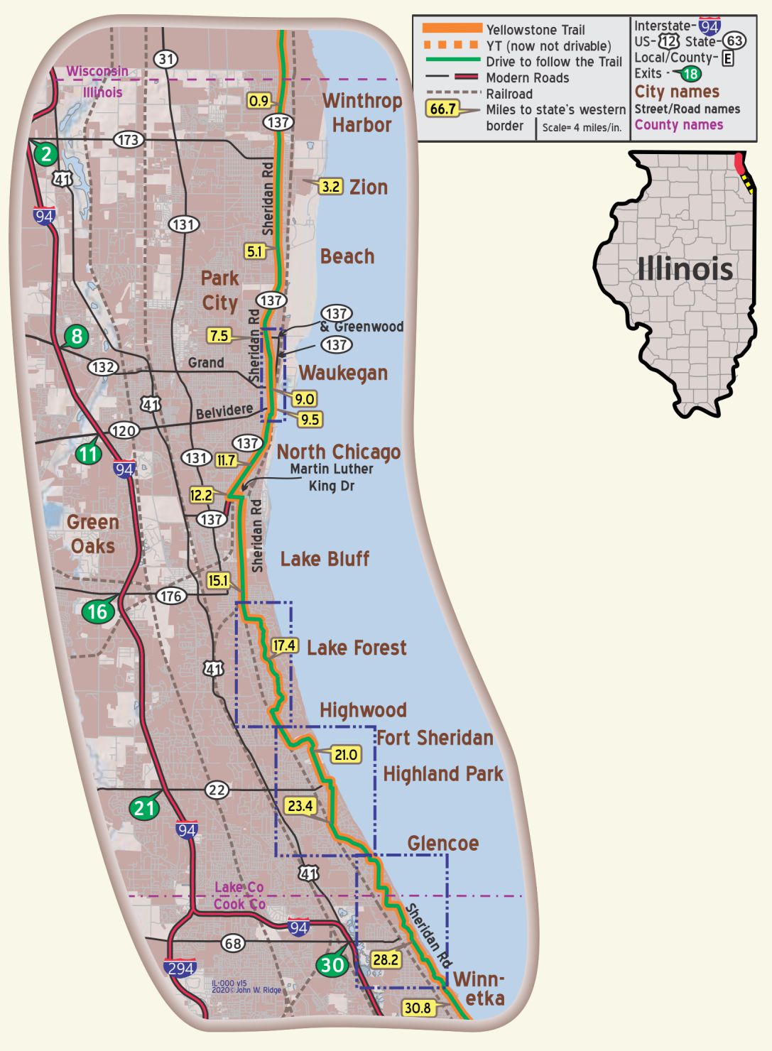
 IL-017.4 Lake Forest
(pop. 5,000, alt. 704 ft.), situated on the shores of Lake Michigan, 28 miles from Chicago, is a city of beautiful homes and surroundings, its site being diversified by picturesque ravines and bluffs. Many Chicagoans make their summer home here, while others are all the year round residents. It contains the Lake Forest university and Lake Forest academy, two leading educational institutions. BB1921-10*
(713 alt., 6,554 pop.), is known as the wealthiest of the North Shore suburbs. Magnificent estates, many surrounded by high iron fences, border both sides of State 42. Large groves of timber outline beautifully landscaped lawns; statues, formal gardens, pavilions, and stone benches are placed with an eye to beauty and functional use; occasionally a tennis court or swimming pool is visible from the road. The architecture of the costly homes, many silhouetted against the blue waters of Lake Michigan, ranges from the elaborate pre-World War styles to the straight-line modernity of Frank Lloyd Wright. WPA-ILw*
This affluent city is one of several comprising the “North Shore,” a geographical area known to all.
555 N Sheridan Rd. (Yellowstone Trail). Lake Forest College, founded in 1857, is a four year coed, residential, private liberal arts college.
700 N Sheridan Rd. Across Sheridan Rd. from the college stands the Presbyterian Church. The bituminous limestone used in the construction of the present 1886 building was salvaged after the 1871 Chicago fire from the Second Presbyterian Church in that city.
NOTE: Between IL-018.9, at Westleigh Rd., and IL-020.1, at Old Elm Rd./Simonds Way, the route of the YT is not well documented. It is hypothesized without evidence that it followed a now obscured route nearer the cemetery.
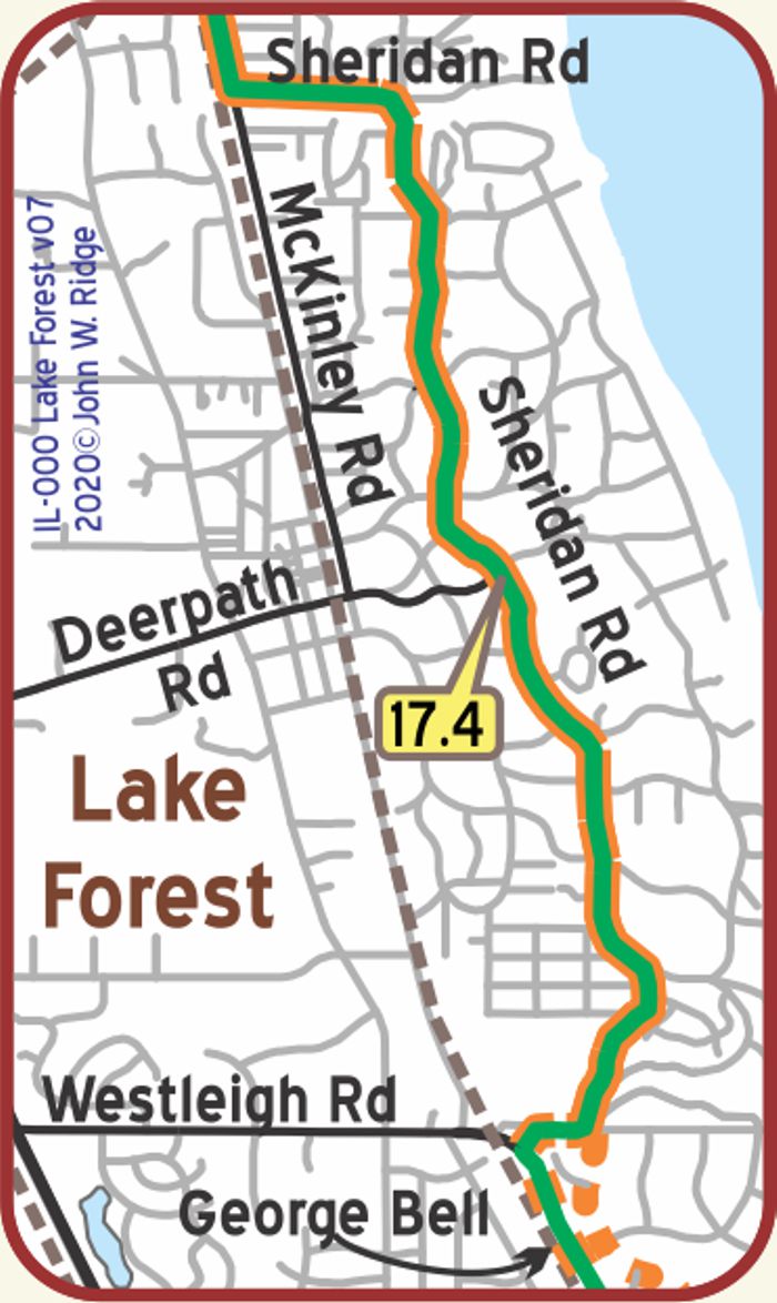
 IL-021.0 Fort Sheridan
built a quarter of a century ago, c.1890, it is beautifully situated on Lake Michigan and is, at present, the largest general hospital in the United States, having a 5,000 bedding capacity for patients. During the war it was a training camp for officers, and since the armistice its work has been devoted entirely to the reconstruction and rehabilitation of wounded soldiers. BB1921-10*
Separating the “town” of Fort Sheridan from the military Fort is difficult. The Fort Sheridan website says that Fort Sheridan is a residential neighborhood spread among Lake Forest, Highwood, and Highland Park in Lake County. It was originally established as Fort Sheridan, a United States Army Post named after Civil War Cavalry General Philip Sheridan.
In 1984 parts of Fort Sheridan were designated a National Historic Landmark District by the National Park Service as the site “possesses national significance in commemorating the history of the United States of America.”
When the main fort was officially closed by the Army in1993, the majority of the property was sold to commercial land developers. Approximately 90 acres of the southern end of the original post were retained by the Army; there the Army now operates the Sheridan Reserve Center and recruit training center complex.
IL-023.0 Highwood
Highwood is situated just west of Sheridan Rd. Highwood is a quiet North Shore residential community with lovely homes built from stone, brick, and masonry by local Italian stonemasons. Highwood is also a community shaped by Fort Sheridan; Highwood’s business district was once so notorious for its bars and taverns that its knickname was “Whiskey Junction.” From Evanston to Kenosha, Highwood was the North Shore’s only wet community.
IL-023.4 Highland Park
(691 alt., 12,203 pop.), one of the largest residential suburbs of the North Shore, stands on the site of two Potawatomi villages. White settlement began with the construction of the Green Bay House (1834), a tavern on the Chicago-Milwaukee post road, now Waukegan Road.
On Sheridan Road, opposite the entrance to Lake Shore Country Club, is an Indian trail marker, a bent tree that the Potawatomi twisted as a sapling to mark one of their trails. WPA-IL*
Hotel Moraine on Yellowstone Trail &Sheridan Rd. BB1925*
Like other North Shore towns, Highland Park sits on top of a high bluff running along 6 miles of Lake Michigan shoreline with deep, wooded ravines extending up to 1 mile inland.
Pioneering architect, Frank Lloyd Wright, designed several “Prairie Style” homes here with some, like the Willits House, on the National Register of Historic Places. A mansion owned by basketball star Michael Jordan and designed by Wright is located just north of Highland Park. Oak Park, to the west, can claim the most homes by Wright in one place, at least 17.
In addition to several houses designed by Wright, the National Register lists homes in Highland Park designed by other prominent architects.
200 Ravinia Park Rd. Ravinia Festival Park. A few feet off of Sheridan Rd. is the oldest outdoor music festival in the country. It started in 1904 as an amusement park to lure riders to the newly founded Chicago and Milwaukee Electric Railroad. No doubt Yellowstone Trail travelers stopped here. The tradition of live annual open-air summer musical performances continues to today. We went when the weather was absolutely perfect.
326 Central Ave. Highland Park Historical Society. It is housed in a 12 room Italianate Victorian house which preserves the history of Highland Park and surrounding area.
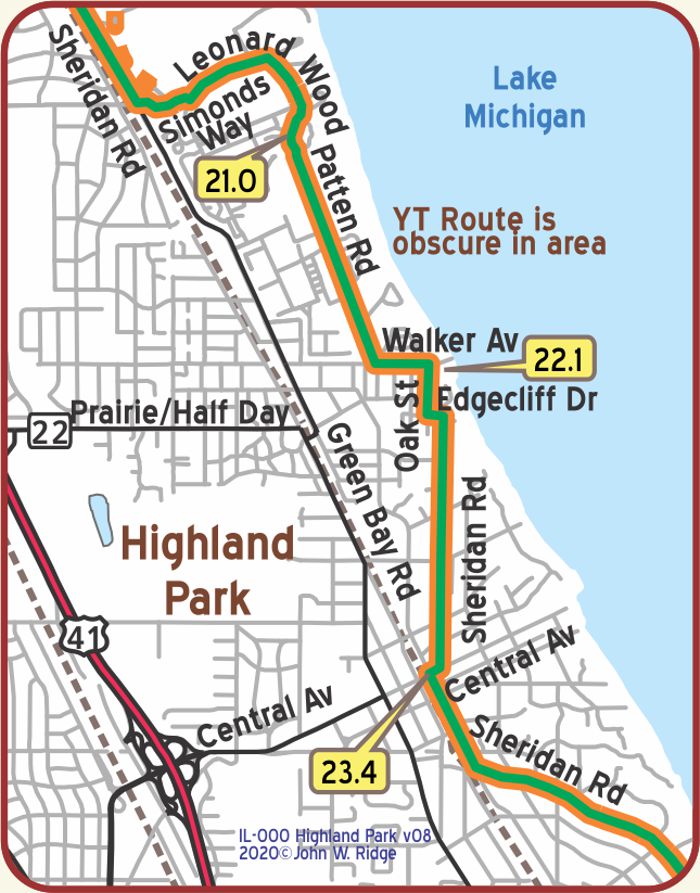
 IL-028.2 Glencoe
(673 alt., 6,295 pop.), was first settled about 1836, and was incorporated as a village in 1869. The name is a compound of “glen,” suggestive of the site, and “Coe,” the maiden name of the wife of Walter S. Gurnee, one of the founders. The Gurnee House (private), a three-story yellow brick building with elaborate porches and gables, still stands on Green Bay Road, opposite the North Western station. It was built in the 1870s. WPA-IL*
There are 9 Frank Lloyd Wright homes in Glencoe, two of which are on Sheridan Rd.
Glencoe is part of a unique walking/biking trail that runs along on the Old Green Bay Rd. to the North Shore villages. It is called the Green Bay Trail. The Green Bay Trail began as the road between Chicago and Green Bay, Wisconsin. At the end of the 19th century (1898), the North Shore Electric Railroad ran a line from downtown Chicago north to service commuters from the many developing suburbs. For most of the early 20th century, what is now the trail was used as the right-of-way for the North Shore Line. When the railroad abandoned the Shore Line route, the villages along the line cooperated in purchasing the right-of-way to be used as a walking and bike trail. Today, the trail is utilized by thousands of runners and walkers. The Old Green Bay Rd. runs parallel to and within a couple of blocks of the Yellowstone Trail for some of it.
375 Park Ave. The Glencoe Historical Center and Eklund Garden hosts exhibits, events, and a research center. At this writing they are featuring the end of World War I Centennial.
NOTE: IL-029.7 In this area the Yellowstone Trail has a
ravine and twists and turns with beautiful homes along the side. About as close to an open road that one can find in a city.
 IL-030.8 Winnetka
On Tower Road, L. of the highway, is the Water Tower (1893) of the community-owned and operated water plant. The plant, at the base of the steep bluff on which the tower stands, is integrated with the municipal electric plant, resulting in numerous economies in the operation of both. WPA-IL*
This affluent North Shore village is located approximately 16 miles north of Chicago. As you drive along Sheridan Rd., the Yellowstone Trail, note the many large, stately and beautiful homes with backyards that look upon the lake.
The Chicago, North Shore, and Milwaukee electric interurban railway was built through Winnetka and the North Shore in the first decade of the 1900s, and the line through Winnetka was removed in 1955. This is now the Green Bay Trail bicycle path.
411 Linden Ave. Winnetka Historical Museum. The collections of the Winnetka Historical Society reflect and document the development of the Village since the 1830s and include archives, over 3,000 photographs, and artifacts.
784 Sheridan Rd. Christ Church-Epicopal. “The Church on the Hill” is aptly named because of its location on a hill on Sheridan Rd. Dedicated in 1905, it was surely viewed by Yellowstone Trail travelers on Sheridan Rd.
IL-032.2 Kenilworth
(615 alt., 2,501 pop.), is named for Sir Walter Scott’s novel, and many of the streets in its hilly residential section commemorate places or characters in the book. WPA-IL*
15 miles north of downtown Chicago. As of the 2010 census it had a population of 2,513. It is the newest of the nine suburban North Shore communities bordering Lake Michigan, and is the only one developed as a planned community. In January 2011, Forbes named Kenilworth “the most exclusive neighborhood in the Midwest.”
IL-033.6 Wilmette
(pop. 4,943, alto 614 ft.), is a pretty suburb 14 miles north of Chicago. Here many of the most prosperous business men of the city make their homes the year round, while others spend only the summer months. There are many very fine drives in and around this picturesque village that would prove most enjoyable. BB1921-10*
The village is named in honor of Antoine Ouilmette, a French-Canadian fur trader.
The Village of Wilmette is a beautiful suburb, known for its “lakefront, tree lined streets, green street lanterns & brick streets,” says the Wilmette website.
The North Shore Channel was constructed by the Chicago Sanitary District in 1909 and 1910 to control the flow of water from the Chicago River to the lake. Clay excavated from the channel was deposited nearby as landfill which became the Willmette Harbor and Washington (later Gillson) Park. The second major engineering project was the construction of Sheridan Rd. to replace the old Green Bay Trail. The
Yellowstone Trail route through the area was established in 1915 on Sheridan Rd. so that road was built by then, allowing Trail travelers views of Washington (later Gillson) park and the large harbor and Lake Michigan.
100 Linden Ave. at Sheridan Rd. The Baha’i Temple is one of only seven Baha’i Temples in the world and the only one in the U.S. They held their first religious service in the uncompleted building in 1922. After many pauses in its construction, it was finally completed in 1953. The beautiful, white lace-style exterior detail is set off by the lush landscaping and fountains. The white tower is visible as one drives along Sheridan Rd., and surely those travelers on the Yellowstone Trail viewed it abuilding.
609 Ridge Rd. The Wilmette Historical Museum. Besides chronicling local history, the history society sponsors an annual Spring Housewalk, celebrating the preservation of local homes.
The Oak Circle Historic District is a 2.4 acre historic district. It includes fifteen single-family homes representative of the Prairie School and Craftsman styles of architecture. The Oak Circle Historic District is on the National Register of Historic Places.
Ouilmette North Historic District is a 46 block area placed on the National Register of Historic Places for local significance. It extends from Chestnut Ave. on the north to Sheridan Rd. on the east to Lake Ave. on the south to 13th St. on the west.
1122 Central Ave. The Wilmette Theatre. Built in 1914, and after several renovations and changes in ownership, the theatre still thrives. From silent Mary Pickford to the “talkies” to “Pirates of the Caribbean” and art films, the Wilmette Theatre drew and still draws crowds. It is certainly historic.
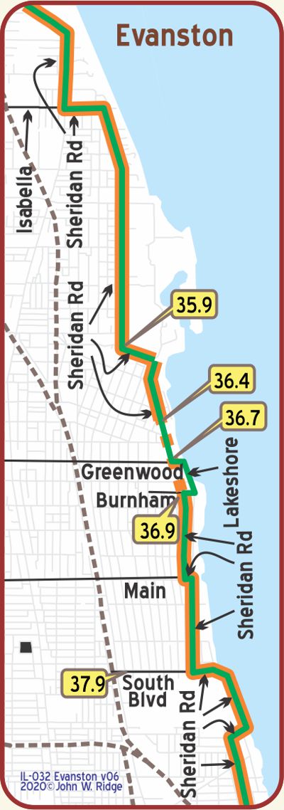 IL-035.9 Evanston
(pop. 35,000, alto 601 It.), one of Chicago’s pretty and aristocratic suburbs, is located at Lake Michigan. It is the headquarters of the National Woman’s Christian Temperance Union (WCTU), Northwestern University and Garrett Biblical Institute. BB1921-10
1730 Chicago Ave. Frances Willard Memorial Library and Archives. Northwestern University and Garrett Biblical Institute were both founded by strong Methodists who, long before Prohibition in the 20th century, voted Evanston dry in 1863 and so it remained until the 1970s. It is no surprise, then, that the headquarters and president of the Woman’s Christian Temperance Union, Frances Willard, were situated in Evanston.
1841 Sheridan Rd. might be the place to start if you want to visit the Northwestern University campus. This place has maps and undergraduate information. Like other huge urban universities, Northwestern is not just in one place. But a visit to view a slice of a major midwest university is worth the time.
225 Greenwood St. Evanston History Center in a chateau-style house built in 1894, once home to U.S. vice president Charles Dawes. It strives “to capture and teach Evanston’s rich history,” they say.
NOTE: The YT route between IL-036.4 and IL-036.7 is now used by a parking lot with north bound traffic. Going south is detoured around the area, follow posted signs. The YT route between IL-036.7 and IL-036.9 is indeterminate.
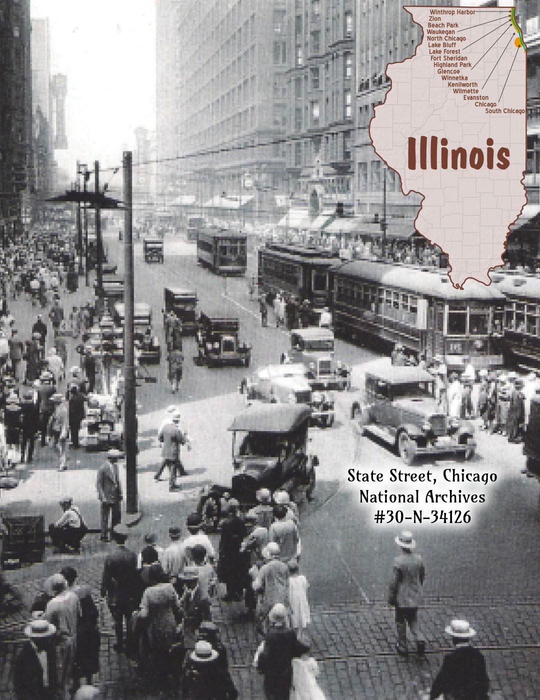
 IL-050.1 Chicago
Chicago is today (1921) the second largest city in America as well as the largest railroad center in the world. Its population as given by the 1920 federal census is 2,701,705. Thirty-nine railways, including twenty-four great railway systems, about 40 per cent of the railway mileage of the U. S. terminate in Chicago, in addition to which there are a large number of belt lines, etc., greatly increasing the trackage within the corporate limits. Chicago has more than 11,000 factories; the output of its manufacturing zone is $6,500,000,000 annually. It is the distributing center of the U. S. and the financial center of the west, the metropolis of the richest agricultural section in the country and the focus of its primary facilities for industrial development. It also has the largest market for live·stock and is the first grain board in the world. Fifty million people live within one night’s ride of this great city. BB1921-10*
It is impractical to mention here the historical, manufacturing, artistic, or cultural attractions of Chicago and their location in relation to the Yellowstone Trail. There is no sign of the old Trail left to see in Chicago. In about 1915 when the Trail went through, the Yellowstone Trail Association found little support or interest by the citizens. This is not surprising and was portent to the things to come in major eastern cities. After all, they had roads to choose from in their cities. Should travelers wish to head west, there was the Yellowstone Trail Association Chicago bureau to supply them with maps and a connection to the next bureau in Milwaukee which would send them on to Minneapolis, etc. For a more full explanation, see Trail Tale: YTA, page <?>.
The August 22-28, 1920, This Week in Chicago booklet advised visitors and residents to see entertainments that Yellowstone Trail travelers could have seen and could still be seen today: Grant Park, Academy of Sciences and the Zoo at Lincoln Park, Field Museum of Jackson Park, Newberry Library at Walton Place, Michigan Ave., and Clark St.
 In 1922, one could select any of five tours of Chicago offered by T&S Tours for $1.00/hour. Four tours were within Chicago city limits; one tour to North Shore towns was all day for $5.00. “Just call Harrison 3566 or show up at their office 302 South Clark St.”
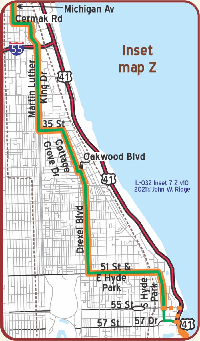
But the Trail did go through Chicago on a long complicated route:
Sheridan Rd. to Michigan Ave. zigzagging to Drexel, then to 57th St. where today it is under US 41.
Then US 12 into Indiana. When we mapped and followed the Trail through Chicago for the first time, we found ourselves among the huge Esso gas tanks in south Chicago.
The traveler today would do well to check the maps on these pages to find a more driveable route to avoid those gas tanks.
1601 N Clark St. Chicago Historical Society.
Monroe at State St. (two blocks west of the Yellowstone Trail, Michigan Ave.) The Palmer House. This historic hotel with an opulent frescoed lobby is very close to the Art Institute of Chicago and close to many famous sites tourists want to see. Surely, some Yellowstone Trail travelers stayed here.
 The first Palmer House was opened on September 26, 1871 and burned down 13 days later in the great Chicago fire. Rebuilt on the same spot in1875, seven stories of iron and brick. Opulent again. Rebuilt in1923-25 to 25 stories and opulent. Surely the Yellowstone Trail travelers would have seen the tallest hotel in Chicago as they passed by two blocks away on Michigan Ave. Today it is called The Palmer House-A Hilton Hotel and has amenities unlikely in the 1920s.
7th and Michigan. (Yellowstone Trail). The Blackstone Hotel, now the Renaissance Blackstone Chicago Hotel, is housed in a 1910 beaux arts building across the street from Grant Park. This elegant hotel is 0.8 miles from the Field Museum. Since it was right on the Yellowstone Trail and near other tourist attractions in Chicago, it is no wonder that Trail travelers may have stopped here.
The hotel has housed many of the world’s colorful, famous, and infamous from presidents to crooks in the past 100 years. Unfortunately, it became shuttered and bought and sold until 2008 when it reopened after renovation, the owners staying true to its historic elegance, while adding contemporary amenities.
Chicago Cultural Center and its Tiffany dome. Entry at 78 E Washington St. About 110 N. Michigan Ave. (the Yellowstone Trail.) Atlas Obscura says that this architectural wonder on Michigan Avenue, the former Chicago Public Library, should be visited to see the most magnificent Tiffany dome ever created. Colorful mosaics, 1,134 square feet of them, including 30,000 panes of glass is the largest of its kind in the world. Completed in 1897, the dome is estimated to be worth $35,000,000 today.
910 S Michigan Ave. The Karpen Building. Built in 1911 for a furniture store, then owned by Standard Oil; it now houses a bank. In Yellowstone Trail days it also housed a company that produced valuable auto road guides. The Automobile Blue Books were essential to drivers in this pre-road map era. Volumes covering 12 geographical areas of the U.S. were published every year from 1901 to 1929 guiding drivers, mile-by-mile, along various routes. Difficult to follow today when one is directed to “turn left at the red barn.”
3301 S Indiana Ave. (between 33rd St, and Martin Luther King, Jr. Dr.) the address of the former iconic Pilgrim Baptist Church. The 1890 renowned church burned in 2006, almost entirely, rendering the landmark a shell. Fortunately, plans, backed by many organizations, made the shell a National Museum of Gospel Music in 2019.
IL-057.9: Between E Hyde Park Blvd. and S Lake Shore Dr., the YT followed E 55th St., which now is closed at S Lake Shore Dr. Using E 57th (near the Museum of Science and Industry) is advised. South of this point the actual alignment of the YT to 67th St. is obscure.
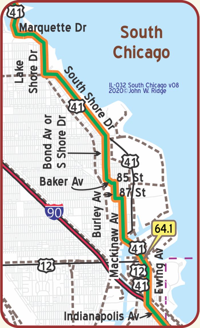 IL-064.1 South Chicago
The YT crossed the Indiana border on Indianapolis Blvd., which now is nearly under the I-90 Skyway. From Indianapolis Blvd. north the trail follows US 41 on Ewing Ave.