
 The map’s green circle markers
are modern highway exit numbers
used for current location reference.
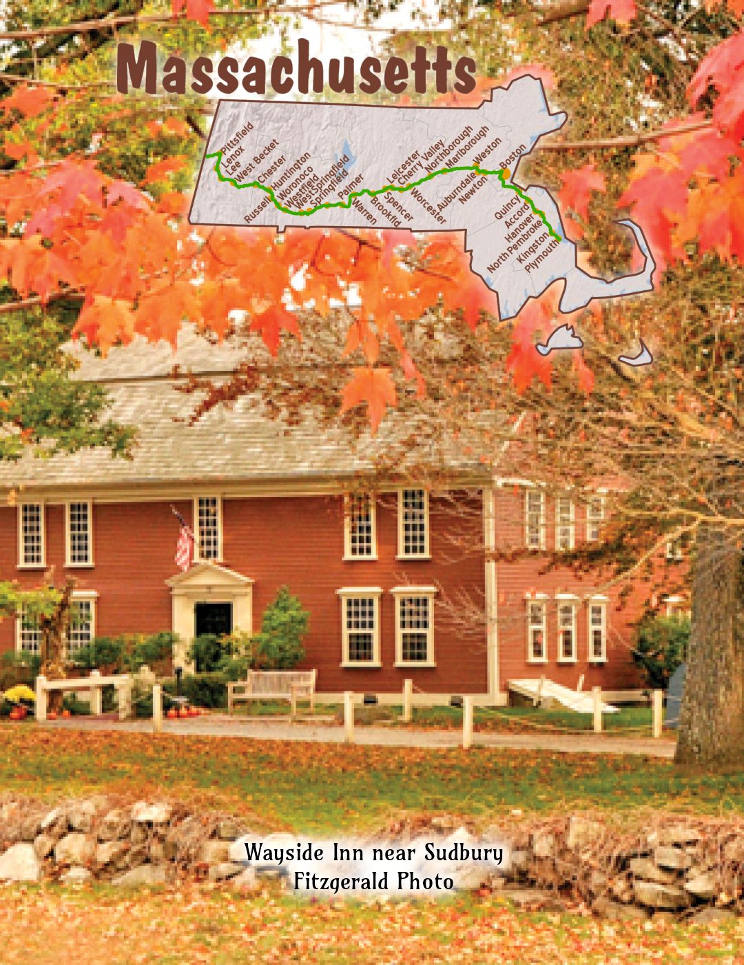
 The map’s yellow rectangle mile markers show path of YT and distance to state’s west border. Click the corresponding number in text for directions and more information.
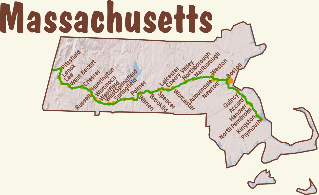
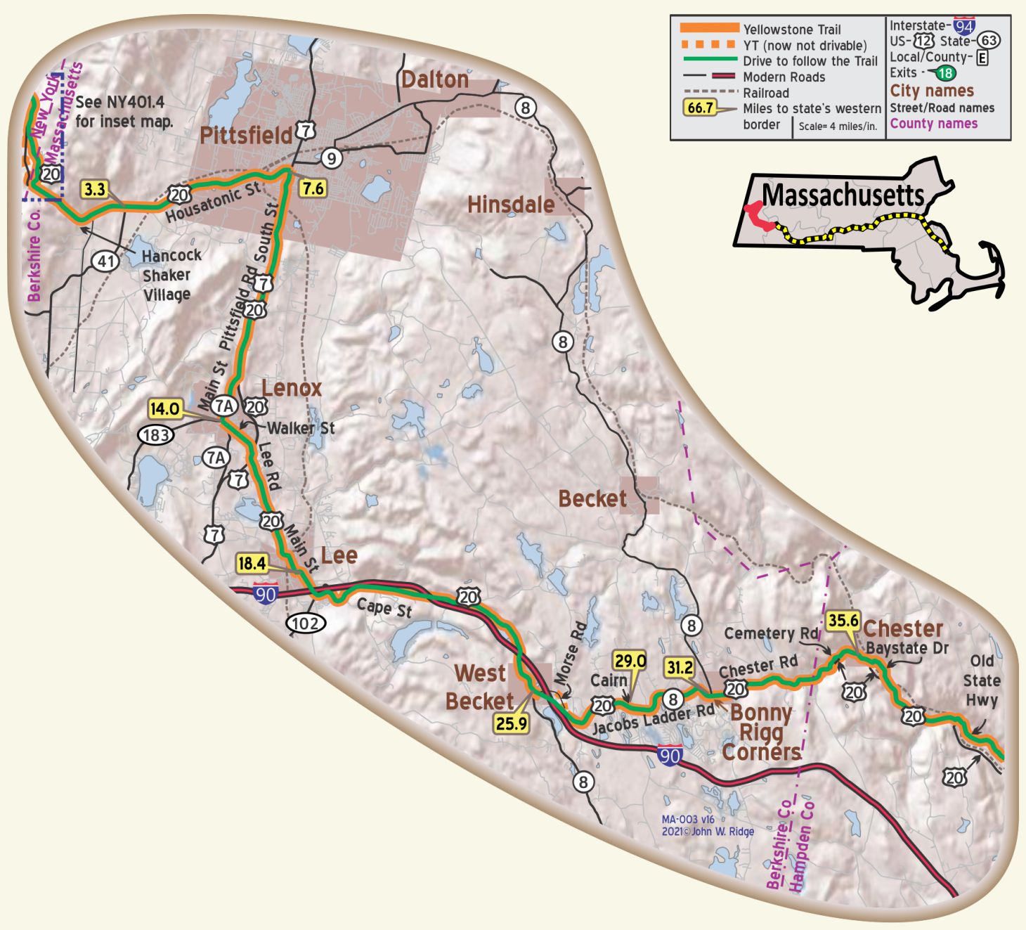 For Directions, click the Massachusetts YTA Mile Marker Numbers (below) linking you to a real-time map.
MA-000.0 New York/Massachusetts Line
MA-004.0 Hancock Shaker Village
The Shakers were one of the earliest religious cults to sprout in New York and Massachseetts. Its distinguishing tenets were celibacy, community of property, spirituality, and refusal to take oath or bear arms. The social unit was the large ‘family’ housed under one roof, but the men and women eating and lodging separately. The physical paroxysms accompanying their religious exercises gave rise to the name ‘Shaking Quakers’ later abbreviated to Shakers. WPA-NY*
A combination of communism, industry, and inventiveness built a prosperous society during the nineteenth century. Wide markets were found for Shaker herbs, garden seeds, blankets, brooms, and chairs. They were called ‘Shakers’ because of their active dancing during services. This United Society of Believers in Christ’s Second Appearing believed also in celibacy, so the sect’s exclusive dependence upon converts and the adoption of orphans to recruit its numbers led to a slow disintegration until today there is only a handful of aged Shakers left. WPA-NY*
1843 Housatonic St. (US 20/Yellowstone Trail). About 4 miles east of the New York border is Hancock Shaker Village. Established in 1783, Hancock Village thrived as an active Shaker community during most of the following two centuries. It brings the Shaker story to life with sixteen farm buildings, including the 1826 round stone barn. The Village is a National Historic Landmark.
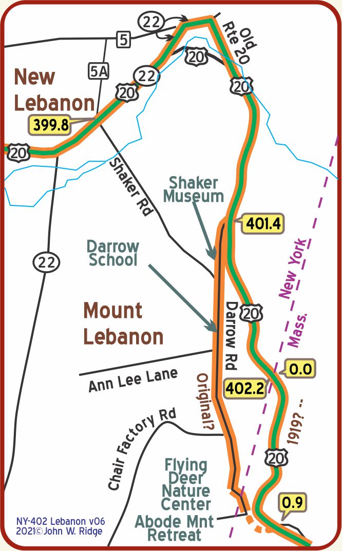 NOTE: MA-000.8: The probable original YT (now overgrown) headed west from Massachusetts into NY. Just within New York it passed the present Shaker Museum (not the Hancock Shaker Village in Massachusetts), which is just southeast of New Lebanon, NY, on Shaker Road. See blowup map (right) and driving note near NY-402.2 from the New York Mile-by-Mile page (bottom).
MA-007.6 Pittsfield
The town was incorporated in 1761 and named in honor of William Pitt, Earl of Chatham.
The manufacturing industries of Pittsfield include at least twenty-six separate lines of industry, and comprise about 100 establishments. Chief among these is the plant of the General Electric Co., covering 133 ½ acres of land, with a large output of electrical machines and devices. BB1921-2*
The old Appleton Mansion, girlhood home of the wife of Longfellow, is still standing on East street; it is now the Plunkett homestead. Longfellow spent several seasons at this house, writing there the “Old Clock on the Stairs” and other poems.
780 Holmes Rd. Herman Melville’s ‘Arrowhead’ home is the headquarters of the Berkshire Historical Society. The Society’s website says:
From 1850 to 1863 Melville and his family called Arrowhead home. It was here he wrote some of the most influential American fiction, including Moby Dick. Surrounded by nature, friends Nathaniel Hawthorne and Oliver Wendell Holmes, and inspired by majestic views, Melville settled into domestic and professional peace if only for 13 years.
The artifact collection represents over 200 years of history, available for exhibit and research. The archives contain over 200 cubic feet of manuscripts, 170 linear feet of books, maps, 350 oral history tapes, and 14,000 photographic images.
39 South St. Berkshire Museum. Art, history, and natural science are combined in interactive displays with an emphasis on youth activities. Greek and Chinese art, and paleontological items are displayed.
Pittsfield is located in the far western reaches of the Berkshire Mountains, an area well advertised as a “foremost destination for cultural events and natural beauty.” Some of the highlights are:
Tanglewood, summer home of the Boston Symphony Orchestra;
Jacob’s Pillow Dance Festival;
and various other festivals and museums.
NOTE: MA-007.6 (Pittsfield) to MA-031.2 (Bonny Rigg Corners): The Clason Maps for 1927 and other years show the route of the YT heading east from Pittsfield through Dalton, Hinsdale, and Becket and south to Bonny Rigg Corners. YTA materials never identify that route and always indicate that Lenox and Lee are on the YT. Furthermore: Assuming the Scottish community of Bonny Rigg is the source of the name, the variants Bonnyrigg, Bonny Riggs and others are probably not correct.
WAYSIDE – Crane & Co. Museum of Papermaking, 66 Downing Industrial Park, is a little east of Pittsfield and off the Yellowstone Trail, but is an interesting historic place. Approach it from West Housatonic St. in Dalton. Crane has been producing special watermarked paper for the printing of money, bank notes, and postal notes since 1770 and still produces paper for the Bureau of Engraving and Printing in Washington, D.C.
MA-014.0 Lenox
(pop. 3,000, alt. 1,270 ft) occupies a slightly elevated plateau in the midst of a scenic highland section, mostly covered with forests, sprinkled with attractive lakes and traversed by several picturesque streams. BB1921-2*
Lenox is a quaint, prosperous town set in a pastoral area at the base of the Berkshire Mountains.
In the late 19th century wealthy families had summer “cottages” (mansions) here.
2 Plunkett St. Edith Wharton’s home, “The Mount,” is in the countryside, a little south of Plunkett St. This remarkable woman was a prolific writer and designer of homes and gardens. She designed “The Mount” and lived in it 1902-1911, but she spent most of her life in France. The home is a National Historic Landmark. She won the Pulitzer Prize for Age of Innocence in1920, the first woman to win in the fiction category. The home features her library, restored rooms and three acres of formal gardens.
6 Main St. Curtis Hotel. Built in 1829 on the site of an inn since 1770. It boasted many a famous guest, among whom were U.S. President Chester A. Arthur, Horace Greeley, William Tecumseh Sherman, and John Jacob Astor. The ground floor was restored historically, leaving it a stately colonial brick treasure. It is now senior housing.
104 Walker St. (Yellowstone Trail). Ventfort Hall. This 1893 Gothic-looking brick and brownstone 50-room mansion was built for J. P. Morgan’s sister Sarah and it witnessed a number of influential visitors of that age. The movie “The Cider House Rules” was shot in and around the Elizabethan-style mansion. By 1997 the house was seriously damaged, but saved and returned to elegance and offered as a museum and tribute to “the Gilded Age” with tours, lectures, exhibits, and events.
10 Willow Creek Rd. (one mile east of Lenox) Berkshire Scenic Railway Museum. The restored 1903 Lenox Station contains exhibits about railroading and the economy it built for the region.
WAYSIDE – 297 West St. Tanglewood, the summer home of the Boston Symphony Orchestra and summer music school. Summer concerts, student recitals, chamber groups, and entertainers all perform classical, jazz, and folk music in the various venues on the campus. The 550-acre estate includes Hawthorne Cottage where Nathaniel Hawthorne wrote several books. The first concerts began in 1936, six years after the demise of the Yellowstone Trail Association, but this historic entertainment site is worth the side trip.
Tanglewood’s main entrance is 1.4 miles west of Lenox on Route 183 (West St.).
MA-018.4 Lee
(pop. 4,481, alt. 900 ft.). Paper making was established here at an early date and flourished on a large scale for many years. Though since exceeded in quantity of production by other cities in western Massachusetts, it is still the leading business. An important industry now is marble quarrying. Several hundred thousand headstones have been shipped from Lee to mark the graves of U.S. soldiers, particularly in national cemeteries. BB1921-2*
85 Center St. Joe’s Diner has been a western Massachusetts institution since 1939. It is claimed that Joe’s Diner was the inspiration for Norman Rockwell’s 1958 Saturday Evening Post cover, “the runaway,” the little boy runaway and policeman treating him to a snack at a diner. The magazine cover is prominently displayed. It is not a classic diner architecturally, but just a very small greasy spoon with a devoted clientele. Reviewers say, “What makes Joe’s Diner special is that it is a slice of Americana. The walls are covered with photos of famous people who ate there.”
25 Park Pl. First Congregational Church of Lee. This beautiful Italianate church was built in 1858 and has the tallest steeple in the country. It’s white and can be seen from quite a distance.
Appalachian Trail Scenic Byway crosses Jacob’s Ladder. (GPS: 42.29036, – 73.15557). That is about five miles east of Lee and about three miles west of West Becket. There will be a sign, but don’t run over the hikers. It is called a Scenic Trail for good reason. This part of that scenic trail is especially beautiful through forests.
WAYSIDE – Norman Rockwell Museum – Stockbridge, MA. About five miles southwest of Lee on state hwy 102 is Stockbridge, home of the Norman Rockwell Museum. His paintings, especially those on the cover of the Saturday Evening Post magazine, reflected American culture and were popular world-wide. The museum displays many of the most popular pictures and explains how some of them were created. Most of his work was done post-Yellowstone Trail days, but this museum is included here because it is so much a picture of Americana in the 1930s and 1940s that it is a history lesson in itself.
WAYSIDE – Jacob’s Ladder. The part of the Yellowstone Trail now called Jacob’s Ladder Trail, begins just a few miles west of Lee in the Berkshire Mountains. It is a 35-mile-long Scenic Byway through historic rural landscape beginning here at Laurel Lake in the west and ending at Tekoa Mountain, near Russell, to the east in the southern Berkshires. As its name implies, the road climbs up into the lower Berkshire Mountains. The Yellowstone Trail traversed this route and, although today it seems a bit more “tamed” than 100 years ago, it still takes one back to a slower and simpler time of travel.
MA-025.9 West Becket
Nearby is Jacob’s Pillow, a long-time dance academy mecca. The Jacob’s Pillow Dance Festival is something truly special. Running from June through August, the festival features vibrant dance performances from over 50 international dance companies.
NOTE: Near MA-026.8 is a short stretch of Morse Rd. which carried the YT and old US 20, that was overridden by the building of I-90.
MA-028.9 The Cairn
Here at the summit of Jacob’s Ladder, at the corner of Fred Snow Rd., is a pile of rocks, the Jacob’s Ladder memorial cairn (GPS: 42.25860, -73.08640), which has stood for over 100 years to commemorate the 1910 opening of the road which was then perceived as a great accomplishment, opening transportation from central to western Massachusetts.
MA-031.2 Bonny Rigg Four Corners
Jacobs Ladder Scenic Byway alt. 1265. (GPS: 42.25870, -73.08595).
Here is the foot of Jacob’s Ladder; the climbing highway opens up many vistas of beautiful mountain country. WPA-MA*
On a small plateau lies Bonny Rigg Four Corners, a famous old stagecoach crossroads from which State 8 runs right. WPA-MA*
Jacob’s Well is a wayside spring dating from ox-cart days. Near the top of the Ladder new forests of white pine are slowly restoring the richness of the woodland, damaged by an ice storm in 1920. WPA-MA*
NOTE: Near MA-034.8 where Cemetery Rd. intersects US 20 is a bit of an old highway left when the newer US 20 smoothed the curve.
MA-035.6 Chester
(town, alt. 601, pop. 1363, sett. 1760, incorp. 1765), was incorporated as Murrayfield, in honor of John Murray, treasurer of the proprietors. Ten years later the citizens voted to change the name, apparently as a result of his Tory sympathies. When Murray left the country in 1778, he was forbidden to return. WPA-MA*
Agriculture, including the production of maple sugar from 1800 trees, and the mining of mica, emery, and corundum have been the chief occupations of the people. The granite quarries are less important than formerly. The advent of the railroad here drew the population away from Chester Center. WPA-MA*
US 20 drops gradually down into a marshy valley where lies Shaw Pond (camping); along its western bank, off State 8, is a thriving cottage colony. WPA-MA*
15 Middlefield St. (MA 20 & Yellowstone Trail). Chester Historical Society at The Old Jail, built in 1840. The Society’s mission is to preserve Chester’s heritage and historical buildings. The society maintains resources for local history or genealogical research, as well as a large collection of items from Chester’s industrial past.
10 Prospect St. Chester Railway Museum. Their website says:
The Western R.R. was completed and it was also the largest and most difficult railroad project ever attempted. When complete, it was the highest (1458 ft.) and longest (150 miles) railroad ever built (1841) and included the longest bridge in the world, across the Connecticut River at West Springfield, Massachusetts.
WAYSIDE – Keystone Arches near Chester. Along the length of the west branch of the Westfield River sit the first keystone arch railroad bridges built in America. They range in height to 70 feet and made possible the longest railroad in the world, the Western Railroad, in 1840. Most impressive of these edifices were ten keystone arch bridges.
The construction of the arches took place during the late 1830s, and the line opened in 1841. “The stated purpose was to reach the Erie Canal in Albany and get in on the orgy of trade with the interior,” said David L. Pierce of Friends of the Keystone Arches Inc. “The canal traffic never amounted to much, due to the fact that The Western Railroad (later Penn Central, CONRAIL and CSX) ended up bringing about an end to the canal era and launching the railroad revolution in earnest.”
From Chester take Middlefield St. At about 2.5 miles north, an information sign for the arches is easily found.
Middlefield-Becket Stone Arch Railroad Bridge District is on the National Register of Historic Places. Middlefield vicinity.
MA-035.8 to MA-036.4 and MA-038.7 to MA-042.7 are interesting sections of the old YT with some poor gravel and mostly nicely paved.
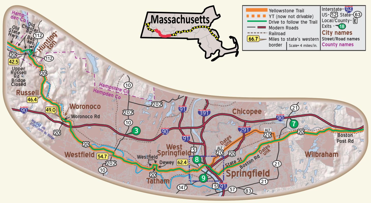 MA-042.5 Huntington
72 Worthington Rd. Norwich Bridge School. Huntington Historical Society manages this 1800s school which was so used until 1919. Since then it has been used for a variety of purposes. About 1971 it was restored to its original purpose and may be seen now as an old one-room school.
Huntington Village Historic District is on the Register of Historic Places. Roughly along E Main, Main, Russell, Upper Russell, and Basket.
MA-046.4 Russell
This is the last town on the east end of Jacob’s Ladder.
RUSSELL (town, alt. 266, pop. 1283, sett. 1782, incorp. 1792). Here in 1858 the Chapin and Gould Paper Mills were established. These paper mills, with those in Woronoco and Westfield, are the chief support of the area. WPA-MA*
The old highway followed Woronoco Rd. from MA-048.5 to MA-049.5.
MA-048.9 Woronoco
(alt. 255), is best known as the home of the Strathmore Paper Company Plant across the river. The village is at the junction with State 17. WPA-MA*
MA-054.7 Westfield
Westfield claims to produce 95 per cent of the world’s whips, and has the largest bicycle manufacturing plant. “Crane’s Linen” paper is also produced here. BB1921-2*
The Westfield Athenaeum (open weekdays, 9-9; Sun. 2-6), corner of Elm and Court Sts., overlooking the Green, is an attractive brick building with limestone trim, housing the library. On the upper floor is the Edwin Smith Historical Museum. WPA-MA*
87 S Maple St. Joseph Dewey House. The Joseph Dewey House is a Georgian colonial built in about 1735 for Joseph Dewey, whose family had been living in the Westfield area since the mid-17th century. It stayed in Dewey hands for about 100 years, then went through a succession of owners. In the 1970s, under threat of demolition, it was carefully restored to its early colonial state.
171 Main St. (US 20/Yellowstone Trail). Landlord Fowler Tavern. According to Mass.historicbuildings.com, it was built around 1761 (perhaps as early as 1755). Daniel Fowler was granted a tavern license in 1761 and the building continued to function as an inn until the 1830s. At the start of the American Revolution, Daniel Fowler served on the Committee of Correspondence, which met at the tavern. It is said that General Burgoyne, when he passed through this town as a prisoner from the field of Saratoga, spent the night at this tavern.
More recently, the former tavern has been restored and converted into apartments. The Fowler Tavern‘s original Connecticut River Valley broken scroll pediment doorway was removed in 1920 and placed in the Metropolitan Museum of Art in New York.
Westfield was home to several whip-making businesses, which gave it the name of “Whip City.” See Whip City History Bit. All of them are on the National Register of Historic Places, three are on the Yellowstone Trail, and all are in the expanded Westfield Center Historic District.
1259 Western Ave. Sackett Tavern, a National Underground Railroad Site, one of 14 such recognized in Massachusetts by The Network to Freedom, a program administered by the National Park Service to recognize and tell the story of resistance against slavery in the United States through escape and flight. This tavern was built around 1776 for Stephen Sackett, who ran the tavern. It changed owners several times until William Fuller restored it in 1962 with painstaking care to stay faithful to Georgian colonial construction and detail. It was sold again in the 1990s as a private residence.
70 Park St. Josiah Day House is the oldest known brick salt-box style home in the United States. By 1754 the house had been built and was handed down to family until 1902 when it came to the Ramapogue Historical Society. An addition was added in 1812. It was preserved in its original state and contains an enormous fireplace in each room plus many items and furniture of the Day family. It is on the National Register of Historic Places.
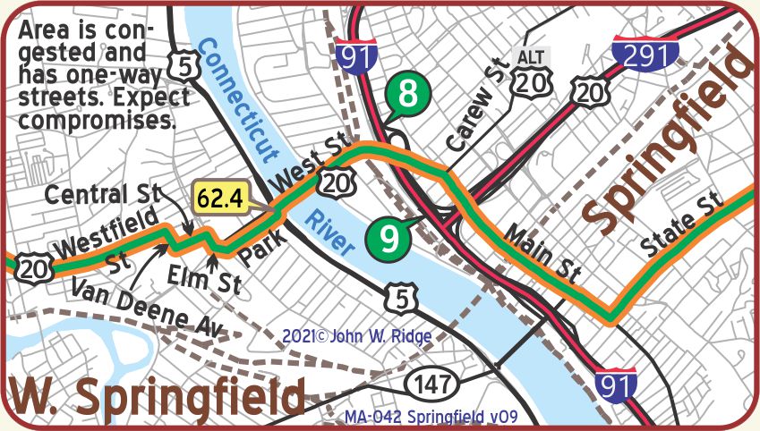
MA-062.4 Springfield
(pop. 129,556, alt. 204 ft.) is preeminently a manufacturing city. Among its products are rifles and revolvers made for the U. S. government, railway and trolley cars and sporting goods of various kinds. Webster’s Dictionary has been published here for many years. BB1921-2*
Eighty-two properties are on the National Register of Historic Places and several large commercial buildings (“Blocks”) on Main St., are on the Yellowstone Trail.
1571 Main St. (Yellowstone Trail). The Worthy Hotel is an historic hotel. Built in 1895 and advertised as “Springfield’s leading commercial and tourist house,” the Worthy Hotel was Springfield’s finest hotel until the opening of the Hotel Kimball in 1911. Located only two blocks south of Springfield Union Station and featuring 250 rooms, the Worthy Hotel’s period of greatest significance was from 1895 to 1925. It is on the National Register of Historic Places, and is currently an apartment building.
Bridge and Chestnut Sts. Hotel Kimball opened in 1911. Built in what was an affluent residential neighborhood, the Kimball was elegant, offering 309 rooms, and a large dining room and banquet hall. In 1912, room rates were from $1.50 to $3.50 per day. In 1985 the building was converted to 132 condominiums. It is still looking good today.
21 Edwards St. Springfield Museums: On this five-Museum Campus are the Museum of Fine Arts, Museum of History, Art Museum, Science Museum and the new Dr. Seuss
Museum. Need we say more?
One Armory Square, Suite 2. Springfield Armory National Historic Site. This National Landmark Site houses the world’s largest collection of American military firearms dating from colonial times and offers year-round programs, exhibits, and events.
The armory manufactured arms from 1777 to 1968 for all wars from the Revolution to Vietnam. This advantageous site was scouted by George Washington and General Henry Knox for an arsenal. Thus began a long history of invention and mass production of weaponry.
Note: The entrance to Armory Square is on Federal St. Armory Square is shared by Springfield Armory National Historic Site and Springfield Technical Community College (STCC). (GPS: 42.10731, -72.58131).
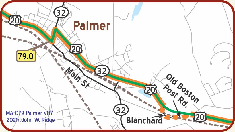
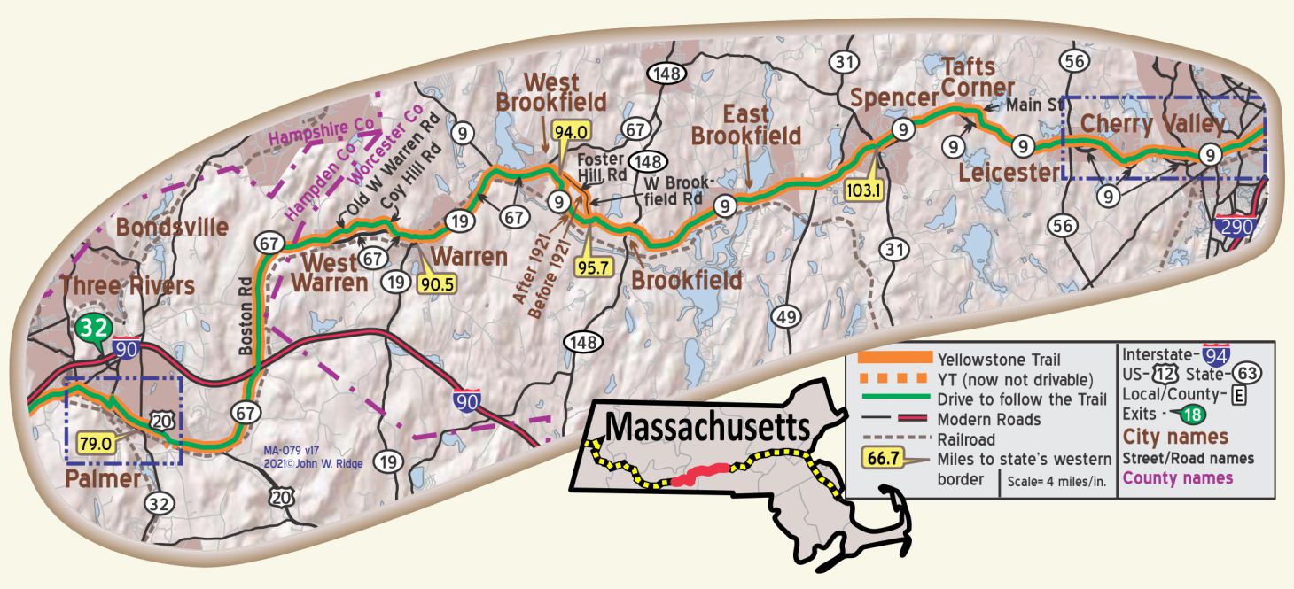 MA-079.0 Palmer
US 20 crosses the Quaboag River. A pile of stones in the middle of the river is the remains of Scott’s Bridge, built in Colonial days and used by General Washington on his way to Boston in 1775. WPA-MA*
Another quaint, pleasant New England town in a rural forest and hilly setting.
28 Depot St. (US 20/Yellowstone Trail). 19th century Union Station and Steaming Tender Restaurant. When the station opened in 1884 it was the third largest in Massachusetts, designed with Syrian arches over the windows. The station’s train platform has been removed. There is a 1915 Porter Steam Locomotive and its Tender displayed on the grounds along with a 1909 Parlor Car available for parties. The restaurant is in the station. Palmer is known as the “town of seven railroads” which were built through the town 100 years ago.
 NOTE: MA-079.0 Palmer – Old West Warren Rd. just NE of Palmer was not YT. Goodrich Northeast guide says road crossed tracks twice near modern interstate, but modern map shows no way to do it.
Crossman Bridge on Gilbert Rd. across the Quaboag River in West Warren. It is one of the few surviving lenticular pony truss bridges in Massachusetts. The 1888 bridge was rehabilitated and reassembled by 2008. The bridge is on the National Register of Historic Places.
NOTE: MA-088.1 West Warren: Goodrich Route Book suggests Warren Rd. was the YT at this location. (GPS: 42.21522, -72.22807).
MA-090.5 Warren
(pop. 4,200, alt. 600 ft.), is a picturesque little town with the Quaboag river flowing parallel with its main street. The old Keyes house, built in 1740, with a grand old elm tree in front, under which Gen. George Washington halted for a drink of water, is still in possession of the Keyes descendants, as is also the glass from which Washington drank. Marks mountain is another point of interest. BB1921-2*
The town has numerous thriving industries. The Warren steam pumps, with which many of the U. S. destroyers were fitted out during the late war, are made here. BB1921-2*
Warren is an old industrial town with a few “British” row houses (front doors close to the street), also some pretty Victorian homes and a village green, all placed in a quiet, woodsy, hilly setting.
According to the Warren Historical Commission, the Boston Post Road was the original main thoroughfare through Warren (now MA 67/Yellowstone Trail). “It took its name from its purpose – it was the route of the colonial postal service from New York to Boston established in 1673. About 100 years later, Postmaster Benjamin Franklin ordered mileposts marking the mileage to Boston. Some of these markers still stand.”
See Trail Tale: Boston Post Road, page <?>.
MA-093.6 West Brookfield
(pop. 1.400. alt. 604 ft.), is noted as place of first publication of Webster’s Dictionary. “Ye Olde Tavern” is a historic building where General Washington, Jerome Bonaparte and bride, and other notables were entertained. It was built in 1760 by Calvin David Hitchcock, and has been operated continuously since that time; it was known at one time as the Hitchcock tavern. Among interesting points are Indian Rock on Foster Hill Road, where George Whitfield preached. The constitution of the state of Massachusetts was drafted here. BB1921-2*
In the two-story Brick Building on Main St., Isaiah Thomas in 1798 edited the first newspaper of the Brookfields. Four years later Ebenezer Merriam & Co. acquired the paper and conducted a general printing business for 60 years. The sons of Ebenezer Merriam opened a printing shop in Springfield and published Noah Webster’s dictionary. WPA-MA*
Note: “Between West Brookfield and East Brookfield are last remaining mile posts placed by Benjamin Franklin as postmaster,” reported a friend. If a reader knows of other locations of other markers, please inform us. Click here for more information.
7 E Main St. (MA 9/Yellowstone Trail). Ye Olde Tavern. It was known as Hitchcock Tavern in 1760 when it was built by David Hitchcock and became Ye Olde Tavern in 1811. Their website says:
Built at West Brookfield in 1760, it was a center of colonial life in Massachusetts. Here many men and lovely ladies of olden times were entertained, for the Tavern was located on the Olde Bay Path [Boston Post Road?] over which sped the stages from Boston to Albany.
George Washington, John Adams, Jerome Bonaparte, and others stopped here.
The historic Tavern was extensively modernized in 2014. Reviewers are happy with the modernization. Some reminders of colonial times remain like the big fireplace, plank flooring and period furniture, but recessed lighting in a drop ceiling reminds us that change happens.
West Brookfield Center Historic District on the National Register of Historic Places. Roughly Central and Cottage Sts. from Sherman St. to Lake St. and W, N, and S Main Sts. from Chapman Ave. to Maple St.
27 Front St. (Central and Front). Quaboag Historical Society Museum in the old train station. This Museum represents the collected history of several small towns in the Quaboag Plantation area: North, East, West Brookfield, Brookfield, Warren and New Braintree. In this early history-laden part of the country there is certainly much to see.
MA-096.3 Brookfield
(pop. 1,500, alt. 850 ft.). Important point on the old stage route between Boston and Albany; the Brookfield Inn remains as a landmark of those days. Writing desk once owned by Louis XVI now in Merrick Public Library. Shoes and coated paper are the chief local industries. BB1921-2*
The Brookfield Inn (open), on State 9, with low ceilings, a taproom, and a sign dated ‘1771,’ still has the atmosphere of an ancient hostelry. WPA-MA*
8 W Main St. (MA 9/ Yellowstone Trail). Historic Brookfield Inn. From the Brookfield Inn website:
The Brookfield Inn was built in 1768, [other sources say 1771] and historically provided a resting place for presidents and aspiring presidents, as well as travelers from all over the world. Since its last heyday in the late 1940s and 1950s, the physical structure deteriorated significantly. Current proprietors, Paul and Melissa Puliafico, purchased the Inn in 1981, and began the process of loving restoration and rehabilitation of the building and property.
In 1789, George Washington traveled through New England, and this has become a basis for all of the ‘George Washington slept here’ claims.
It seems that Washington’s party would have spent the night in Brookfield except for an unfortunate incident.
As the story goes, Washington and his entourage stopped at Brookfield Inn, then owned by a Mrs. Bannister, and wanted to stay the night. Unfortunately, Mrs Bannister was suffering from a migraine headache and turned them away not knowing it was George Washington who wanted to stay the night. Washington moved on to Spencer where the innkeeper there was only too happy to oblige!
MA-099.9 East Brookfield
East Brookfield holds the recognition for the most recently incorporated town in Massachusetts. Although it was first settled in 1664, it wasn’t until 1920 that it was incorporated and named for its geographical location from the town from which it seceded, Brookfield.
108 School St. The Hodgkins School, first built in 1882, was the oldest operating school in Massachusetts until it was closed in 2002. It now operates as the East Brookfield Historical Museum.
MA-103.0 Spencer
(pop. 7,000, alt. 8l ft.), a residential and manufacturing village, is the birthplace of Elias Howe, inventor of the sewing machine, and of William Howe, original designer of the bridge technically known as the “Howe Truss.” Points of interest are the monuments to the two Howes, and one to Capt. Bemis, inventor of a means of taking the spikes out of spiked cannon. BB1921-2*
The Richard Sugden Public Library (open daily, 2-8), Pleasant St., is a brick building with brown stone trim, housing the Spencer Museum founded in 1874. This has a collection of Indian relics and historical objects. WPA-MA*
Spencer Town Center Historic District is on the National Register of Historic Places. Main St. between High and North Sts. was the original District. It has been substantially expanded over the years to cover almost 300 acres.
NOTE: MA-110.1-MA-111.1: Near Cherry Valley/Worcester: Another possible route suggested by its name and location is the block long “Great Post Road” between Apricot and Locust St. It needs good local research!
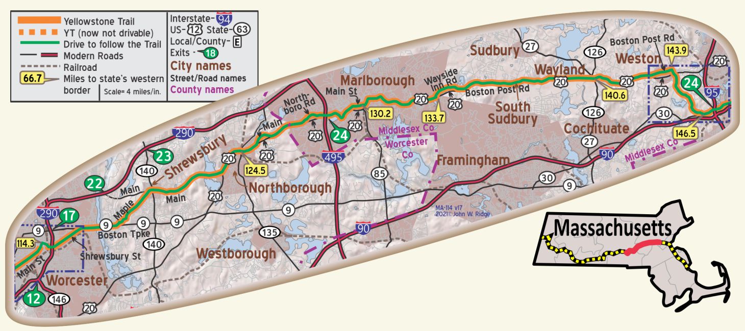 MA-113.6 Worcester
(pop. 190,000,. alt. 481 ft.), built upon nearly a score of gently sloping hills is the largest manufacturing city in the United States not on a waterway. It is the county seat of Worcester county. Worcester is one of the greatest machine tool centers in the United States and the center for rolling mill construction. BB1921-2*
40 Highland St. (Yellowstone Trail/MA 9). Salisbury Mansion. Built in 1772 by Stephen Salisbury, the mansion has been restored to the 1830s period with original furnishings and decor from 1740-1835.
30 Elm St. Worcester Historical Museum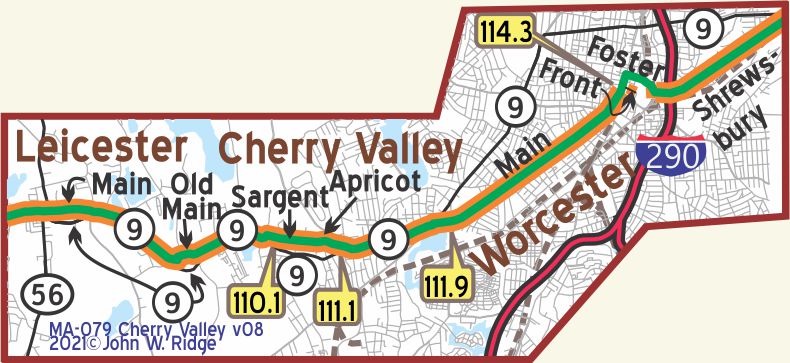 . Weapons, artwork and the textile industry of Worcester are exhibited along with the city’s history.
155 Shrewsbury St. (Yellowstone Trail). Boulevard Diner. The Boulevard Diner is an historic diner built by Worcester Lunch Car Company in 1936. It is a well preserved instance of a barrel-roof diner that the company made in significant numbers in the years before the Second World War, and the city’s best-preserved 1930s diner. It is listed on the National Register of Historic Places in 2000. Yes, this was built after the Yellowstone Trail era, but diners are Americana.
In Worcester, the YT came from the west on Main St. and turned east on Front St. to meet Shrewsbury St.
Most of Front St. does not exist and the detour around on Foster St. is required.
MA-124.3 Northborough
Twenty-three properties and seven districts have been nominated for the National Register of Historic Places. The Wachusett Aqueduct Linear District, along Wachusett Aqueduct from Wachusett Reservoir to Sudbury Reservoir has been listed on the Register of Historic Places.
52 Main St. (Yellowstone Trail). Northborough Historical Society. The history of the town goes back to 1660, the historical society to 1906. It boasts a fine collection of objects of Northborough art and history, with thousands of documents and pictures detailing the history of the area.
191 Main St. (Yellowstone Trail). Chet’s Diner. A classic American diner serves classic diner food; regulars give it 5 out of 5 stars. Little has been done to it since the 1950s, it is said. It is included here because “the diner” is an eastern phenomenon and part of the cultural history.
MA-130.4 Marlborough
At 277 Main St. is the John Brown Bell, taken by Marlborough soldiers from the engine house at Harper’s Ferry in 1861, and hidden in Williamsport, Md., until 1892, when it was brought to Marlborough. WPA-MA*
On the corner of Maple and Valley Sts. is the Dennison Factory which specializes in the manufacture of paper boxes, paper novelties, and office accessories. This is a branch, established in 1925, of the Dennison Manufacturing Company of Framingham.
There are rock walls everywhere east of Marlborough. That tells the traveler about the challenge it must have been to farm this New England land.
Shoe manufacturing continued in Marlborough long after the industry had fled from many other New England communities. Rice & Hutchins, Inc. operated several factories in Marlborough from 1875 to 1929 (while the Yellowstone Trail went through town on Main St.). Famous Frye boots were manufactured here through the 1970s, and The Rockport Company, founded in Marlborough in 1971, continues to maintain an outlet store in the city.
A researcher once found several diners in Marlborough: One moved to the Henry Ford Museum in Michigan, one moved to Chattanooga, Tennessee, and the former White City Diner, a Worcester Lunch Car No. 802, is now operated as the Tropical Cafe just off Main St. at 22 Rawlins Ave.
377 Elm St. The Peter Rice Homestead, home of the Marlborough Historical Society and Museum. House dates from 1688, the society from 1964. A survey conducted in 1994-5 revealed that literally hundreds of houses are historic, dating from the 1600s.
Reportedly, there are 1,767 Milestones between Boston and Springfield along the Old Boston Post Rd.
MA-133.6 Longfellow’s Wayside Inn
See Wayside on previous page and Trail Tale: Wayside Inn, page <?>.
MA-140.6 Wayland
Wayland Center Historic District is an irregular pattern along both sides of US 20 and MA 27. The District and all in it are on the National Register of Historic Places. Concord Road forms its northern border.
Weston Aqueduct Linear District. The area along the Weston Aqueduct from the Sudbury Reservoir to the Weston Reservoir is on the National Register of Historic Places.
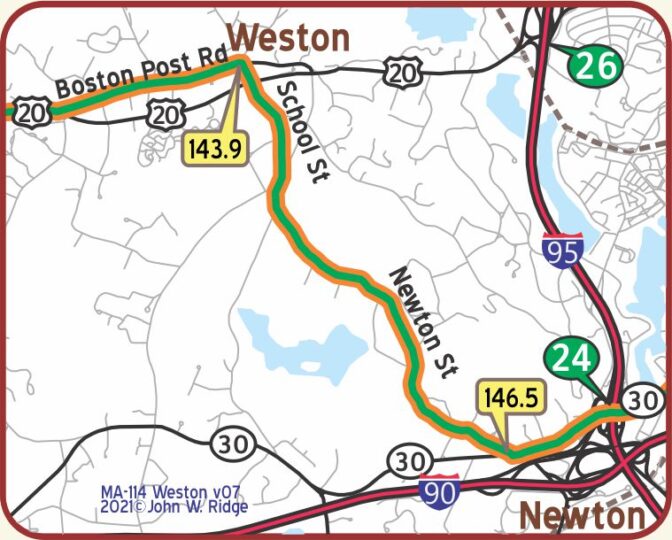 MA-143.9 Weston
Weston appears to be a prosperous, quaint town with much greenery and well-maintained historic homes.
241 Wellesley St. Spellman Museum of Stamps and Postal History features rare stamps, U.S. and international, and has exhibits describing postal history. The Philatelic Research Library is on site. We include this because it may be missed and would interest history buffs following the Yellowstone Trail.
527 Washington Street. Jackson Homestead and Museum. A Federal-style house constructed in 1809, it is a museum containing artifacts of Newton’s and New England’s history and the role of the Jackson home in the Underground Railway.
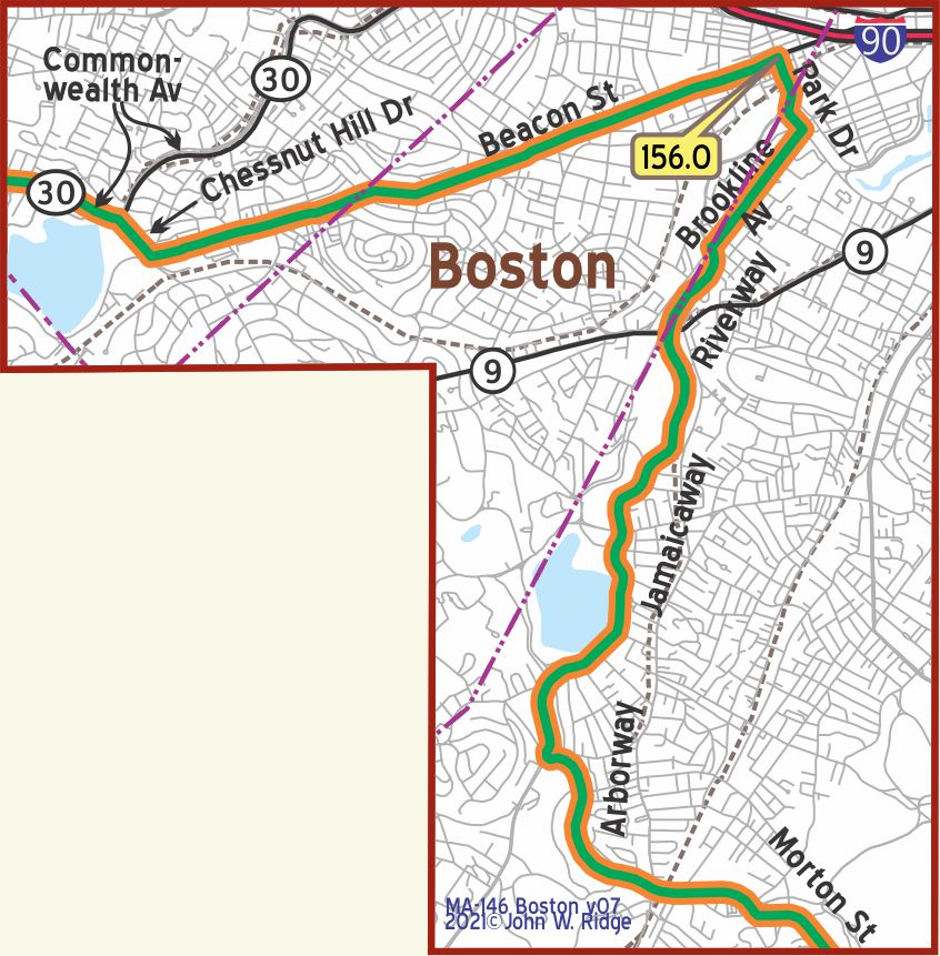
 156.0 Boston
The Trail did not go into Central Boston but skirted it, dropping south to Quincy on its way to Plymouth. That would seem an odd choice, missing a major city like Boston, until you remember that the purpose of the Yellowstone Trail Association was to move people in the most direct way “from Plymouth Rock to Puget Sound” and Boston was not exactly on a direct route.
One hundred years ago, the Trail’s route near Boston would have been somewhat more rural, enabling steady speed with fewer stop signs, despite the electric trolleys and apartment buildings sprouting up in Brookline. Of course, early travelers would probably have gone into Boston for its historic and cultural offerings, but the Association would not compromise in its promise of “the most direct route.”
Driving the Trail today near Boston gives one an entirely faulty picture of the experience of early Trail travelers. Urban growth has obliterated the Trail and any sign of it until you get to Quincy.
The Yellowstone Trail Association maps lacked specificity, especially from Boston to the iconic city of Plymouth.
1250 Hancock St. (Yellowstone Trail). Adams National Historical Park Visitor Center. Access into the historic homes of John Adams and his son John Quincy Adams is by guided tour only. Buses take visitors to the homes.
20 Muirhead St. The Josiah Quincy House. Built in 1770 by Quincy, a prominent lawyer and political leader. The house has period wall paneling and fireplaces surrounded by English tiles in addition to memorabilia from several generations of Quincy descendants.
8 Adams St. (Yellowstone Trail). Quincy Historical Society Museum. Displays feature the history of the area related to shipbuilding and granite stonework. There also are displays of the Adams and Hancock families.
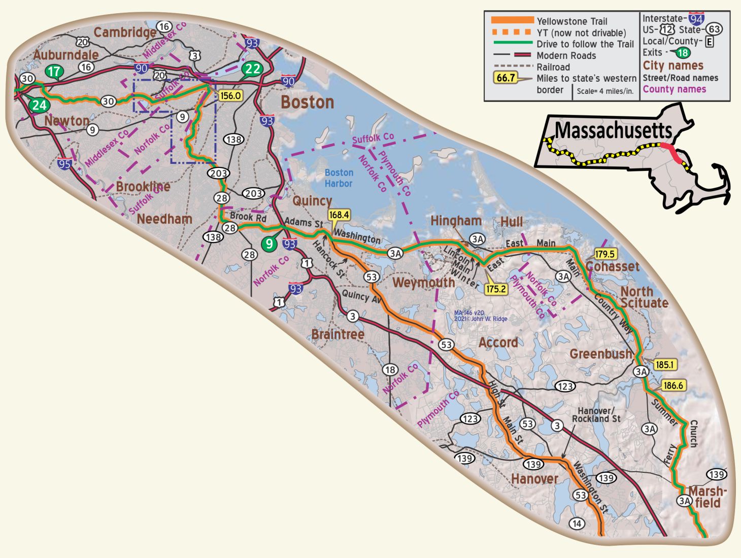
MA-168.4 Between Quincy and Plymouth there were two possible routes of the Trail.
At least one major early road map shows the YT route to be the western route on or near MA 53 as shown on the map. However, the eastern, ocean shore route on or near MA 3A was known as a tourist route and has support as being the route of the YT. We show it as the “driving line” for today’s traveler. The ocean route has an advantage of allowing side trips to see Atlantic Ocean views and varieties of homes. Brant Rock, across from Marshfield, and the ocean residences northeast of Cohasset are suggested.
MA-175.2 Hingham
The Town of Hingham was founded in 1635 and is located in Plymouth County about 15 miles south of Boston.
21 Lincoln St. The Old Ordinary. This 1688 building, enlarged, functioned as a tavern for much of the 18th century. It now serves as a house museum operated by the Hingham Historical Society. There are many touches of life 300 years ago in this former stage stop/tavern. Kitchen utensils, toys, hand-stitched linen bedding, and more are displayed.
90 Main St. (Yellowstone Trail). The First Parish Old Ship Church (Unitarian Universalist) is the oldest church structure in the country, having been built in 1681, and, until this day, continues to be used as a place of worship.
MA-179.5 Cohasset
Once a part of Hingham. It is said that Capt. John Smith visited the place as he explored the coast of New England. Elm Street was known as “Ship Cove Lane” as it led to the ship-building yards.
14 Summer St. Caleb Lothrop House. Built in 1821, a two story hip-roof wood frame house is a well-preserved example of Federal styling. Caleb Lothrop, its builder, was the grandson of a Revolutionary War militia leader, and was descended from one of the area’s first settlers. It is on the National Register of Historic Places.
4 Elm St. Capt. John Wilson House Maritime Museum. The 1810 house contains model ships, nautical items, navigational equipment and Native American artifacts and exhibits which document 19th century life in Cohasset.
100 Lighthouse Rd. Old Scituate Lighthouse. Operated on and mostly off 1811-1994. A very scenic site.
301 Driftway. Scituate Maritime and Irish Mossing Museum. This small museum in Scituate features an exhibit on Stellwagen Bank National Marine Sanctuary shipwrecks.
238 Webster St. Daniel Webster Estate. Visit the beautiful Webster Estate and learn about the famous lawyer, senator, orator and statesman Daniel Webster. He used this 16 acres to conduct scientific farming. The original home burned down in 1878, but was rebuilt by his daughter-in-law. Events such as teas and special seasonal programs are carried on.
Careswell St. Jct. of Careswell and Webster Sts. Winslow House and Cultural Center. The 1699 residence is of Judge Isaac Winslow, grandson of Mayflower passenger Edward Winslow, governor of Plymouth Colony. On the grounds are the Daniel Webster Law office, also an 18th century carriage shed and a blacksmith shop.
105 Alden St. John Alden House Historic Site. This was the last home of Mayflower Pilgrim John Alden. Purportedly built in the mid-1600s but more probably in the early 1700s, it was occupied by the Alden family until 1920. Interesting features of the expanded home (from two rooms) are the powdered clam-and-oyster shell ceiling in the “great” room and the gunstock posts.
120 King Caesar Rd. King Caesar House. Ezra Weston II was called “King Caesar” as he was a shipping magnet. The 1809 house is represented as it appeared in 1820 and displays period furnishings as well as artifacts related to shipbuilding in Duxbury.
Myles Standish Burial Ground is a cemetery and Pilgrim burial site.
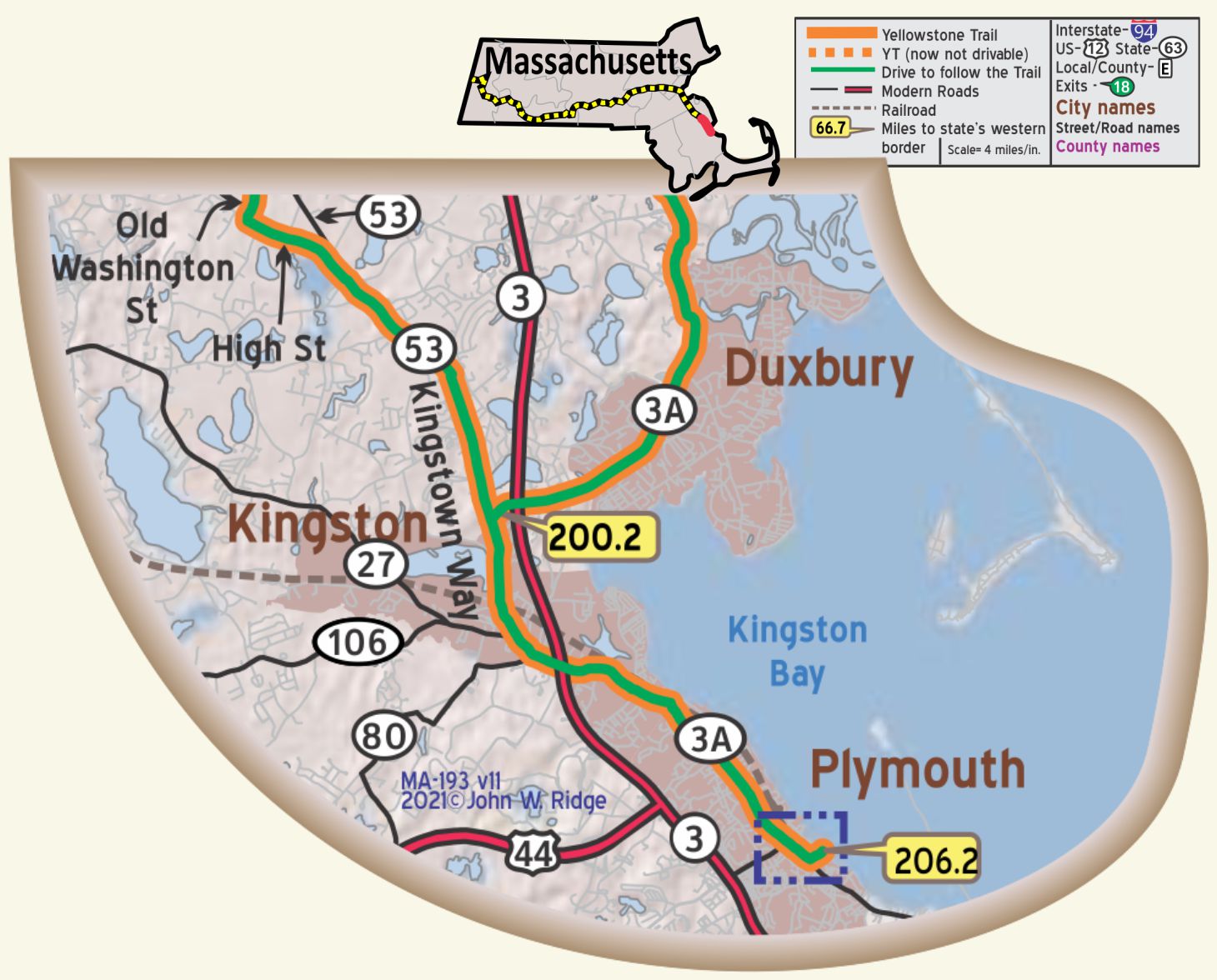
MA-201.8 Kingston
Howlands Ln., Wharf Ln., Braintree Ave. Rocky Nook Farm, the farm of John and Elizabeth Howland, passengers on the Mayflower. John was the last living male passenger still in the Plymouth area. He died at age 80 in 1673 and is buried at Burial Hill, Plymouth. The property is owned and managed by the Pilgrim John Howland Society. The farm burned down in 1673. There is a large granite memorial rock on the property.
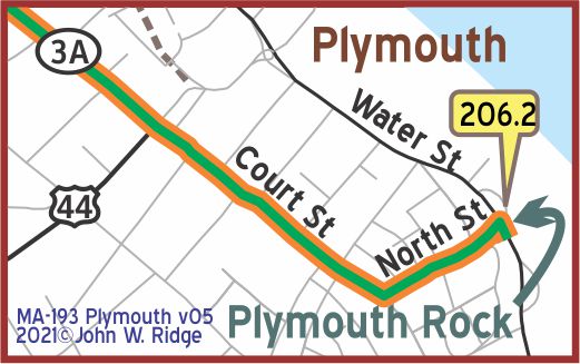 MA-E206.2 Plymouth
We will not repeat here information readily available about the many famous historical sites one can see in Plymouth. We believe that the Trail ran on Court Street, but the Yellowstone Trail Association maps were sketchy in eastern Massachusetts. If you enter Plymouth from the north on MA 3A and drive south down the main drag, you soon find that that street, MA 3A, has several names. Court St. (Yellowstone Trail) becomes Main St. becomes Sandwich St. becomes Warren Ave. near Plimoth Plantation. This is a carry-over from England. We lived in London for a time and found this idea of multiple names for one road to be frustrating.
75 Court St. (MA 3A/the presumed Yellowstone Trail). Pilgrim Hall Museum. Opened in 1824, it houses a collection of Pilgrim furniture, armor, an early American painting collection and a Bible belonging to William Bradford, Plymouth Colony governor. The visitor can even touch a piece of the original Plymouth Rock!
33 Sandwich St. The Jabez Howland House. We include it here because it is not listed in some tourist literature and because one of our authors, John Ridge, is a 15th generation descendant of John Howland, Jabez Howland’s father. This home is the only one left in Plymouth where Pilgrims actually lived. John Howland and Elizabeth Tilley met as passengers on the Mayflower, married, and had lived on present Leyden St. on the four acres that was granted to John in the 1623 land division. They then moved to Duxbury around 1635 and finally to a farm at Rocky Nook (present Kingston) in 1639. He and Elizabeth were known to visit their son Jabez in this 1667 home in Plymouth. Upon John’s death in 1673, Elizabeth lived with son Jabez in this house. “It is fair to presume that its floors have been trodden by those two passengers of the Mayflower, and that its walls have listened to their voices” wrote William T. Davis in Ancient Landmarks of Plymouth in 1887.
Burial Hill. At the head of Town Square, just off Main St., is the site of a fort built in 1622-23 and is the burial place of Gov. William Bradford. Today, on August Fridays, citizens dress in Pilgrim garb and walk from Plymouth Rock to Burial Hill to re-enact the church service attended by the 51 survivors of the winter of 1620-21. It can be seen from School St. or Russell St. We include this site because it is often overlooked, even though advertised.
WAYSIDE – Three miles south of Plymouth on MA 3A is Plimoth Plantation. Founded in 1947, it is a non-profit living history museum that exhibits the original settlement of the Plymouth Colony established in the 17th century by the English. There are outdoor clay ovens, gravel paths, a grist mill and Wampanoag Homesite. Costumed role players portray actual residents. Explore at your own pace in self-guided tours. Click here for more information.