
 For Directions, click the Idaho State YTA Mile Marker Numbers (below) linking you to a real-time map.
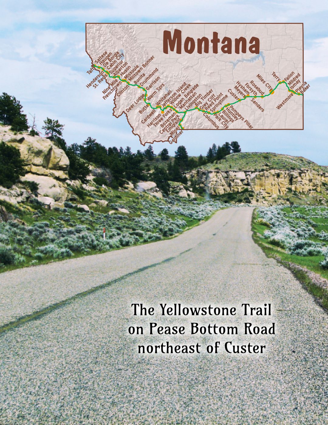
MT-000.1 Mullan Pass-Randolph Creek Road
The original alignment of the Yellowstone Trail over the Idaho/Montana line was through the misnamed Mullan Pass.
This Bitterroot mountain pass had nothing to do with either Mullan or the Mullan Road.
The pass used by the Mullan Road was close to Lookout Pass.
Leaving Mullan, Idaho, going east the route followed the present-day road, Yellowstone Trail, to the pass, then Randolph Creek Road.
This was the original route of the Yellowstone Trail from 1915 until Lookout Pass Road was opened around 1924.
This historic Yellowstone Trail/Randolph Creek route is a great drive today, scenery is great and it is quite usable, yet looks old.
Going west, use I-90 Exit 5, turn immediately right to Co. 286, the Randolph Creek Road.
For the story of Lookout Pass, see Trail Tale: Bitterroots, page <?>.
MT-006.0 Taft
TAFT, MONT., gas, lunch and phone only. Is a nearly abandoned Milwaukee R. R. construction camp. MH-1928*
TAFT (3,625 alt.), is a ghost camp of 3 or 4 unoccupied frame buildings. In 1908, when the Milwaukee Road was driving its St. Paul Pass Tunnel through the Bitterroot Mountains, it was a town of 2,000 inhabitants whose many saloons, gambling houses, dance halls, and flimsy buildings crowded the narrow valley. When Idaho and Washington were dry (no alcohol sold) and Montana wet, Taft was one of the supply points for bootleggers operating in the dry States. WPA-MT*
“The wickedest city in America … plague spot of vice,” said the September 28, 1909, Chicago Tribune. The little town served the Milwaukee Road railroad as a supply and operations center. Two thousand railroad workers blasted an 8,750 foot-long tunnel through mountainous country. Brave “Coyote men” were the blasters whose pay came and went quickly on the town’s 500 prostitutes and 27 saloons. The fire of 1910 flattened the town. Today the tunnel is part of a miles-long, popular bicycle path and Main St. is directly under I-90. The former town is noted by a sign at Exit 5 of I-90. It reads simply “Taft area.”
MT-011.7 Saltese
pop. 100; kept up by mining and lumber. Good bear and deer hunting; also fishing. Rooms and country hotel; no regular garage. Best meals at the restaurant. Blue Slide Camp, 25¢, good site among pines. Lunch and supplies. Fine fishing in St. Regis River.Riverside Camp,50c, dining hall; a good site. 3 cabins $1. Good lunch. MH-1928*
(3,476 alt., 200 pop.), strung out along the highway and railroad tracks in a narrow canyon, is a supply point for small silver and gold mines in the nearby mountains. During the World War, copper mines to the southwest were very active. High above the town the electrified Milwaukee Road clings to a narrow, winding shelf carved from the rocky mountainside. With old-fashioned western hospitality, Saltese keeps the door of its small jail always open, a gesture of welcome to weary hoboes. WPA-MT
I-90 seems to have bisected the town. The Milwaukee Road electric train tressle and “gallows” can still be seen. Main St. and the railroad tracks run along a narrow canyon. It was a supply point for the surrounding mines 100 years ago. Yellowstone Trail travelers may have stopped at the good campground.
174 W Saltese Frontage Rd. (Yellowstone Trail). Old Montana Bar & Grill. An early 1900s building, as seen in moving pictures. Serves bar food and has received rave reviews. Was it always a bar? Would Yellowstone Trail travelers have stopped here for respite while on treacherous mountain roads? We don’t know.
MT-017.5 Haugan
Haugan was one of several area towns to be destroyed during the Great Fire of 1910. MH-1928
Haugan was established and maintained as a “pusher station” for the Milwaukee Road railroad trains ascending the Bitterroot Range of the Rocky Mountains.
MT-017.6 Savenac National Forest Nursery
Savenac National Forest nursery; 30 men employed. MT-WPA*
From 1907-1969 Savenac was once the largest forest service tree nursery in the U.S. Seedlings, mainly pine and spruce, were used in reforestation projects throughout the U.S. Buildings built by the CCC in the 1930s remain and can be used for group events, volunteer maintenance projects and meetings. Today a traveler can walk the grounds at will, as we have done several times. Note the small bridge. It carried the Yellowstone Trail as the present sign on it says; you can see its route through the property. See Trail Tale: Savenac, page <?>.
MT-020.1 DeBorgia
pop. 30; best rooms and meals at Albert Hotel. Gas, phone and open camp space. No garage. MH-1928
Buried in the mountains and forests, DeBorgia was almost completely destroyed in the 1910 fire. Only the school and the bar remained. The school, built in 1908, still stands today, repurposed as a community center.
On a gravel road (The street sign says Yellowstone Trail) just east of central DeBorgia is small Hotel Albert, built in 1911, right after the big 1910 fire. It has been a hotel and bed and breakfast place on and off for decades, and may not be in business now, but you should see its outsides, at least. The false front shows its 1911 western vintage along with the annex, built to be a restaurant which the 1926 Mohawk-Hobbs Guide said served good food. Writer Dave Habura says it served passengers from the Milwaukee Road and Northern Pacific railroads as well as Yellowstone Trail travelers.
1281 E DeBorgia-Haugan Frontage Rd. Black Diamond Guest Ranch. About 15 years ago the then-owners, JoAnn and the late Richard Hopewell, kindly showed us the Yellowstone Trail which traversed the rear of their guest ranch and their 1926 era cabins. The Trail ran from De Borgia to Haugan past the Albert Hotel. With the Yellowstone Trail at their back door and the Mullan Cantonment near their front, they certainly qualify as an historic site. When you stop in there, ask the present owners about the exact location of Mullan’s Cantonment and the Trail.
MT-023.2 – MT-035.9 Camel’s Hump
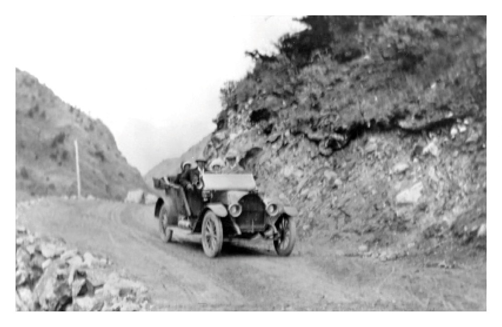
Camel’s Hump, a noted grade, the steepest on the Yellowstone Trail. West side is a 9% grade for a short ways. East side is steep for .8 of a mile and is a 11% grade. Very few cars have trouble. Descend east side in second gear. MH-1928*
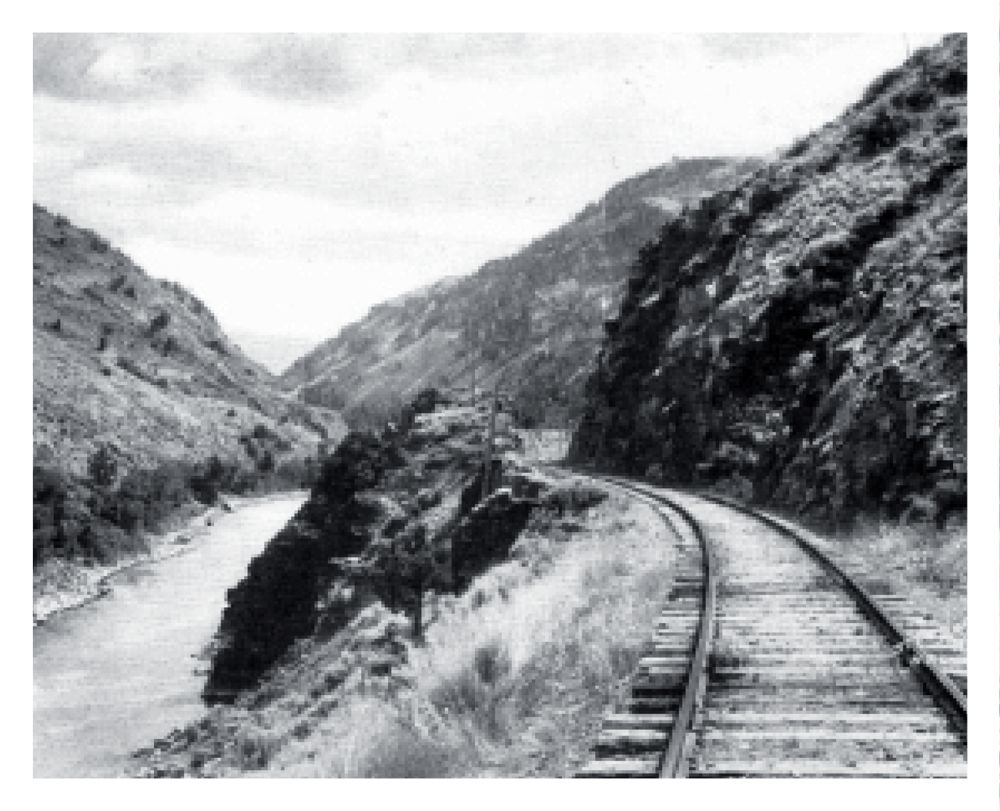
Camel’s Hump was the name given to a 12 mile section of road which, on a map, looks like a “hump” or a half circle road appended to the east side of I-90. The Camel’s Hump route, between the sites of St. Regis and DeBorgia, was created by the Mullan Military Road up and over the mountain to avoid the twisting Clark Fork river canyon that would have demanded numerous bridges. The Yellowstone Trail had no choice but to follow that old route, but plans were soon laid to build the valley road. Those plans were thwarted by construction problems and cost to build in the narrow canyon until 1951. I-90 now follows that river route.
The Interstate was laid down on top of the Yellowstone Trail just east of DeBorgia so today’s Trail traveler must use I-90 between Exits 18 and 22.
Although usually full of snow until May or June, the “Hump” served well, but the 2,200 foot rise of the “Camel’s Hump” gave early drivers the shivers. Today, the trip over Camel’s Hump is on a nice, smooth road with views of hills, valleys, streams, and shady woods of virgin white pine, feathery tamarack, and fir. Here is the Trail at its best. Glenn Koepke, historian, has said that the hump is “still a living museum to the travel history of western Montana.”
MT-024.9 Cabin City
After you have turned onto “Camel’s Hump” via Twelve Mile Road, continue on about 1 1/2 miles to a spot once called Cabin City. Today there is no city there and no cabin. There is, however, a Cabin City Campground on Twelve Mile Road run by the Forest Service.
Cabin City was once known from coast to coast as a popular tourist camp and lodge. It enjoyed more patronage than any other camp on the Yellowstone Trail in this section. The place was conducted as a hunting lodge.
MT-035.8 St. Regis
pop. 250; country hotel and meals. SEARS GARAGE has a good name; 24-hr. service. MH-1928*
2,678 alt., 300 pop.; is composed of straggling clumps of buildings amid convergent railroad tracks. Its center is a bridge across the Clark Fork. Once an important sawmill town, it dwindled to a supply point for small logging operators after the great forest fire that swept western Montana in August 1910. WPA-MT*
St. Regis has a long, significant history in transportation. Old US 10 (Yellowstone Trail) follows part of the historic Mullan Road. The Mullan monument marks that route in St. Regis. The town lies at the confluence of the Clark Fork and St. Regis Rivers. There was an “auto court” near the Trail in St. Regis.
1037 Old Highway 10. Nugget RV Park and Cabins. We don’t know for sure, but it is likely that the site of this present campground is the same or near the campground advertised in Yellowstone Trail era literature. A 1927 Trail Route Folder described the St. Regis campground as right on the Yellowstone Trail and as providing electricity, laundry, and bathing facilities, and it was policed.
MT-050.3 Superior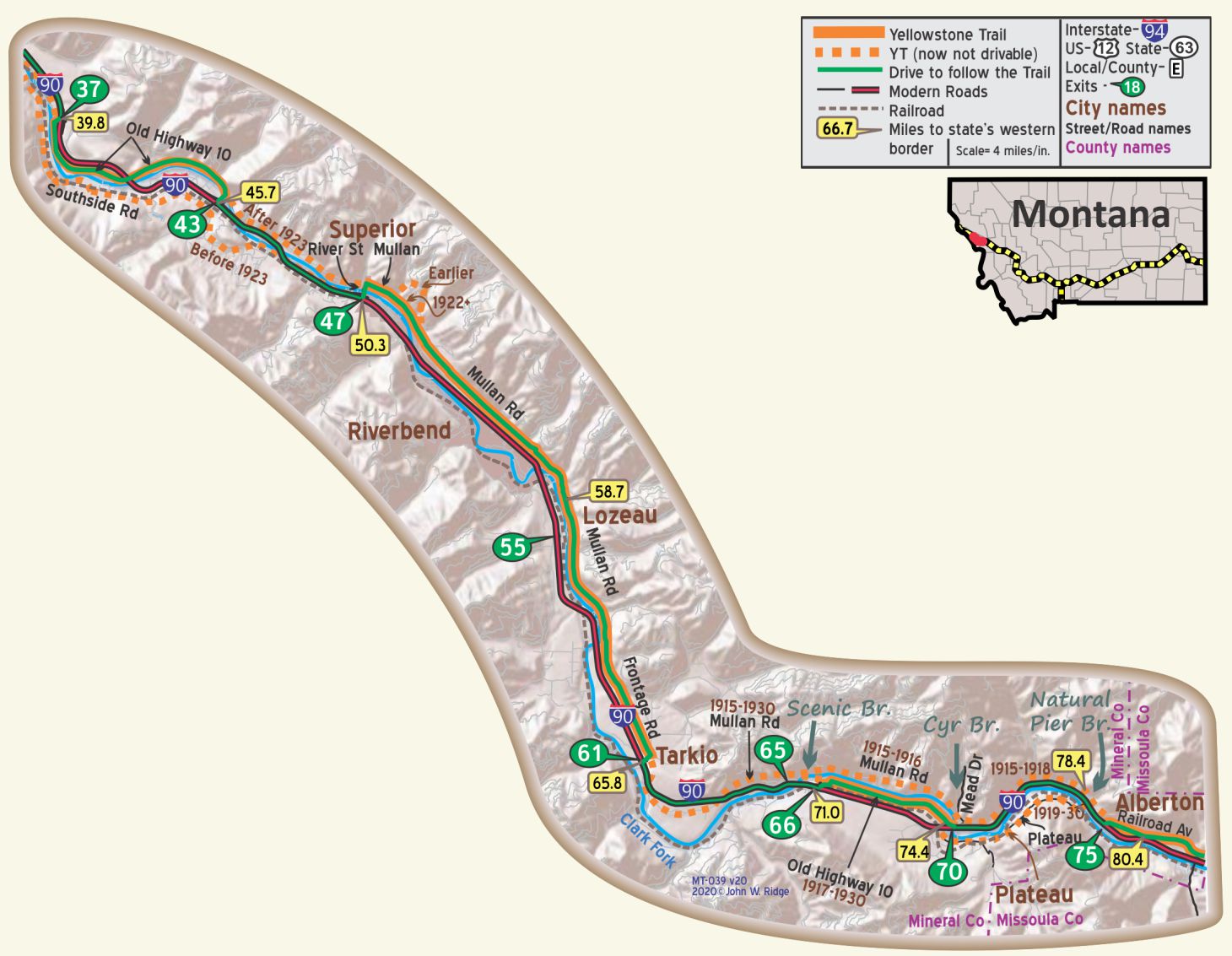
pop. 400; a county seat town; sustained by gold mines and the R. R. Mineral Garage for road service. Good Eats Cafe is liked. MH-1928
CHARETTE HOTEL, good, well kept rooms; hot water and bath in hall. Dbl. $1.50-$2.25. Cafe adjoins. EDWARDS GARAGE, across river, has best mechanics. MH-1928*
Mineral County became an independent county from Missoula County in 1914, the year that the Yellowstone Trail arrived. Superior is the county seat. Through gold rushes, floods, forest fires, the rise and fall of two major railroads, and the great Yellowstone Trail, Superior has survived.
301 2nd Ave. E. Mineral County Museum and Historical Society. These folks are the originators of the important Mullan Society and the annual Mullan Road conference. Displays of mining and other western Montana history adorn walls. Intimate and rewarding.
MT-063.7 Happy Hollow House
Now here is an anomaly. The Trail ran through this farm, called Happy Hollow House. When last we visited, this was the Brickner farm. The Trail ran through the property and exited through their back yard on a small, low bridge over a stream. A larger bridge, carrying the more modern, presently named Mullan Road, is right next to the little Yellowstone Trail bridge. The two historic roads ran parallel for a distance. The Brickners knew of their farm’s historic location on the two roads and fished out an original, rusty Yellowstone Trail sign that was once on their property. Since the Trail disappears into the woods, your driving line on these maps does not route you on to their private property (GPS: 47.05357, -114.75839).
MT-065.8 Tarkio
A Milwaukee Road town and a substation when the Milwaukee Road electrified (which ended in 1973). Lumbering and farming “the Flats” kept the town going. Today the remaining asset is the scenery.
MT-070.3 Scenic Bridge
Scenic Bridge is 10 miles west of Alberton or 4 miles east of Tarkio. Built in 1927-28. Getting to see the Scenic Bridge is tricky. Today, going east, one must leave the Yellowstone Trail and join the Interstate at Exit 61 because the Interstate system has gobbled up the Yellowstone Trail here. Leave the Interstate at Exit 65 and join old US 10 to the bridge which has recently been closed to vehicular traffic. Walk on it and view the Clark Fork river from the bridge and the old Milwaukee Road railroad bridge above it. You must return to the Interstate back to Exit 65 to continue your journey east. If you were westbound, you would leave the Interstate at Exit 66 and follow old US 10, a circuitous route, to the bridge, returning to the Interstate the way you came.
MT-074.4 (I-90 Exit 70) Cyr Bridge
About 9 1/2 miles east of Tarkio or 5 1/2 miles west of Alberton is the 1916 Cyr Bridge at Mead Lane (GPS: 47.00657, -114.57835). Kayakers and river rafters enjoy the Clark Fork River for the Alberton Gorge and its rapids. They put in at the historic Cyr Bridge. See picture on page 90.
From the Cyr Bridge part of the old Yellowstone Trail can be explored. From Exit 70, sawmill Gulch Road can be driven south and east along the 1919 Yellowstone Trail as far as an active rail tunnel. Exciting! No road now connects with Plateau Road to the east which carried the Trail to the Natural Pier Bridge. That 1919 route of the Trail south of the river was billed as the first National Forest Road.
Between I-90 Exit 70 to 75 one is forced to drive on the Interstate. Note the closeness of the Clark Fork River on one side of the Interstate and the mountains on the other. Not much room for train, road, and river.
MT-079.0 Natural Pier Bridge
About one mile west of Alberton is an oddity that you must see. A bridge crosses the Clark Fork River with the help of a large rocky outcrop in the river which serves as the “natural pier” holding up the middle of the bridge. This 1918 bridge is the only natural pier bridge in Montana still extant. In 1999 the structure was rehabilitated and is still in use today.
MT-079.4 Point of Rocks Trail
The Point of Rocks trail is just north of I-90 just west of Alberton. This well-preserved trace of the Mullan Road winds its way around a rocky point. You can still walk through the narrow gaps in the large rocks blasted by Mullan’s crews and still see abutments created from hand-lain rock. At I-90 Exit 75 (the west Alberton exit), follow the North Frontage Road to the west for two miles and look for trail-head signs. This route became the Yellowstone Trail.
MT-080.4 Alberton
pop. 300; a Milwaukee R. R. division point. Clean rooms at Montana Hotel. Billy’s Cafe is liked.
BEAR CAT GARAGE; good mechanics. Labor $1.50; tow car. MH-1928
147 Railroad Ave. (Yellowstone Trail). Antique Depot and Railroad Museum. The Antique Depot is an antiques and collectibles small business located in the original 1890 Northern Pacific railroad station which was moved here from Frenchtown.
701 Railroad Ave. The Milwaukee Road Depot. The railroad was very important to Alberton in Yellowstone Trail days where four passenger trains made 30-minute stops daily. It was a major division point 1908 until 1917 when electrification of the line made division points obsolete; the village had virtually no other industry. Today, the station depot also serves as the Community Center and Library. An authentic boxcar contains the Railroad Museum and “the sweet Caboose inside looks just as it did when it last rode the rails.”
512 Railroad Ave. Montana Valley Bookstore. You’ve got to stop in here. There are over 100,000 books of all stripes stuffed into a small space located in the middle of this quiet, forested, mountainous area. We stop here whenever we pass through.
The building that the book store is in was formerly Bestwick’s Market, a false-fronted commercial building. It is listed on the National Register of Historic Places. Constructed in 1910 with additions in 1915 and 1925, the building housed Bestwick’s Market from 1912 to the late 1950s. The building has housed the Montana Valley Book Store since the 1970s.
818 Rosehill Ln. Alberton School. Built in 1918 symbolized the transition from a railroad boom town to a permanent town. The school survives today virtually unchanged from its original design.
Milwaukee Road Railroad
Look west. It is a short tunnel just a few yards from the Yellowstone Trail and hard to see, but you can imagine a time when the two historic transportation modes existed side by side.
MT-085.9 Nine Mile Creek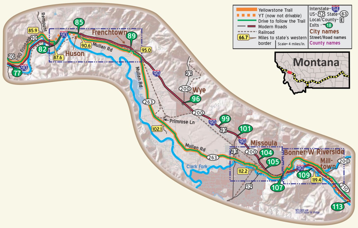
Between Alberton and Ninemile, a very nice drive, is another one-of-a-kind transportation phenomenon. In autumn of 1924 the Yellowstone Trail was built over 9-Mile Creek and underneath the Milwaukee Road railroad overpass. Considered novel when proposed, three railroad crossings and a dangerous curve would be eliminated. Mislead by the mild weather, the contractor poured a 30-foot section of the Yellowstone Trail on December 14. “At noon when the job was finished, the temperature was 65 degrees above zero. By midnight it was 28 degrees below zero, a fall of 93 degrees in 12 hours. The contractor believed that it would have to be replaced. An examination in the spring, however showed it to be entirely unharmed.”
An examination by the state in September of 2013 rated that old Yellowstone Trail bridge as 82.0, “equal to present desirable criteria and open with no restrictions.” Today, the Yellowstone Trail and bridge are clearly driveable, but the middle section of the railroad overpass is missing.
MT-085.9 (Or I-90 Exit 82 at Ninemile Road)
Ninemile Ranger Station and Remount Depot. Besides being the same turnoff for the Yellowstone Trail and the remains of the collapsed Milwaukee Road viaduct over the creek and the Yellowstone Trail, this is also the turnoff to the U.S. Forest Service Remount Depot, north 2.6 miles on Remount Road. A big fire in 1929 gave impetus to the creation of this centralized fire-fighting depot. Ninemile Remount Depot provided experienced packers and their animals for fighting fires and for back-country work projects since the 1930s.
In 1962 it rose again as the Ninemile Ranger Station with training in back-country skills and for firefighting.
MT-090.2 Huson
Between Huson and Frenchtown US 10 climbs over sharp curves to a bench, from which is a view of the Clark Fork Valley.
An observation point provides an equally good view westward to the rugged slopes of the Bitterroot Mountains.
The highway descends into a narrow canyon lined with outcroppings of rock—rusty red, yellow, and brown.
Above, the receding green hills and gulches are topped with pine, larch, and Douglas fir. WPA-MT*
There is some indication that in 1929 the YT ran north of the route shown between Frenchtown and Huson, probably much of it now under I-90.
MT-095.0 Frenchtown
A small village. Rooms and small free camp. Frenchtown Garage is fair. MH-1928*
An old established valley, its settlement dating from 1860 when Jesuit priests set up a mission there. It is not a lumbering town as are its neighbors, possibly because it is located upon an ancient lake bottom. The Frenchtown pulp mill is now an EPA Superfund cleanup site.
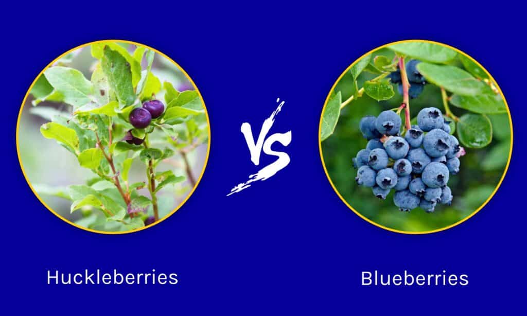
Important advice from the authors:
Don’t confuse huckleberries for blueberries.
Right then you give yourself away as a tourist.
But do order anything huckleberry any chance you get. Yum.
Besides color, an easy way to identify them is to remember that huckleberry bushes grow separate single berries while blueberry bushes grow fruit in clusters on the plant level.
MT-112.2 Missoula
pop. 17,000; is the live trade center of Western Montana. Lumbering and farming, and now sugar beet culture, keep it prosperous. The University of Montana with 2,500 students is here. Dependable information at the Auto Club. Coffee Parlor Cafe is good. MH-1928*
PALACE HOTEL is quiet and popular with tourists. Outside rooms are good values. Sgl. $l-$2.50; dbl. $1.50; outside $2.50; with bath $3.50.
STAR GARAGE has best reputation for all-around service and is open 24 hours. Storage 50c; labor $1.50. Ph. 4740 for efficient wrecker or towing.
Missoula Auto Park, 1.5 miles north; Mercer’s Cottages also north; new and large cottages with good beds $1.25, camp space 50c. MH-1928*
In 1861 two fellows started a store four miles west of present Missoula. That little log cabin store saw plenty of action from the outlaw Plummer gang in the five years of its existence. Then, in 1866 they moved four miles east, started a flour mill and Missoula was born.
Seven historical districts and 27 buildings are on the National Register of Historical Places in this “Garden City” in the valley of the confluence of three rivers. We have selected only a few sites here.
131 S Higgins. Wilma Theater Bldg. Built in 1921, the elegant, restored Wilma now shows a diverse range of entertainment, including movies, spoken word events, music, and plays.
211 W Front. Jeannette Rankin Peace Resource Center. Named for the first woman elected to the House of Representatives in 1916, four years before women could vote. She voted against World War I (with 49 others), and again voted against war in 1941 (alone). The Center continues her peace and justice work through educational programs.
147 W Broadway (Yellowstone Trail). Palace Apartments. The former Palace Hotel was built in 1909 as the Savoy. The original structure and a 1941 annex formed Missoula’s largest single hotel. A 1995 rehabilitation project created 60 upper-floor housing units. Today the Palace low income apartments beautifully illustrate how preservation can help rejuvenate a city center.
250 Station Dr., west of the Higgins Ave. bridge. Milwaukee Road Depot. An impressive double-towered brick structure built in 1910 is now the headquarters of the Boone and Crockett Club, a group formed by Teddy Roosevelt in 1887 to preserve the West. It is on the National Register of Historic Places. You can’t miss its two tall towers. The main floor contains a replica waiting room for passengers and the second floor contains offices and a library of conservation materials. The visitors’ gallery features a time-line history of wildlife conservation. Don’t miss the “Millennium Circle” monument outside. It features names of more great, influential conservationist members than we ever thought existed, including John Muir, Aldo Leopold and others.
120 Hickory St. Montana Natural History Center. There is much more to say about this center than we can here. The Center is an environmental education organization offering kids’ activities, field trips for every age, evening programs, and Montana Public radio programs all focusing on flora, fauna and geology. We picked the Glacial Lake Missoula portion of the Center because it covers a broad area over the Yellowstone Trail. It was marvelous!
You will also want to visit the following as all tell the story of Missoula through the ages:
Fort Missoula with its many outdoor displays;
The University of Montana, South 6th Street;
Smoke-jumper Visitor Center on West Broadway;
Carousel in Caras Park.
MT-119.4 Milltown
(3,521 alt., 552 pop.), exists chiefly because of the sawmill whose yards stretch along the highway and give the town its character. When the mill is in operation, a clean smell of freshly sawed timber re-enforces the visual impression. WPA-MT*
The Milltown Dam (GPS: 46.87176, -113.89256) was an earth-fill gravity-type hydroelectric dam on the Clark Fork River at the confluence of the Blackfoot River with the Clark Fork. Built in 1908 by copper mining tycoon William A. Clark, it was meant to supply hydroelectricity to his sawmills in nearby Bonner. It is no more, courtesy of the EPA.
A new state park, Milltown State Park, has been completed overlooking the confluence of the Clark Fork and Blackfoot Rivers (GPS: Overlook: 46.870491, -113.896589; Confluence area: 46.874408, -113.894014). Hiking trails and interpretive signs aid the outdoors-inclined.
Today, just northeast of the MT 200 Mill town bridge over the Blackfoot River, you will see a through truss bridge that carried the Yellowstone Trail beginning in 1921. It was open to vehicular traffic until just recently, but now is for foot-traffic only. Go on over. Walk on that historic, narrow bridge; look down at the Blackfoot River. Relive a bit of history.
As you drive toward Clinton, notice the steep hills near the edge of the road to the northeast.
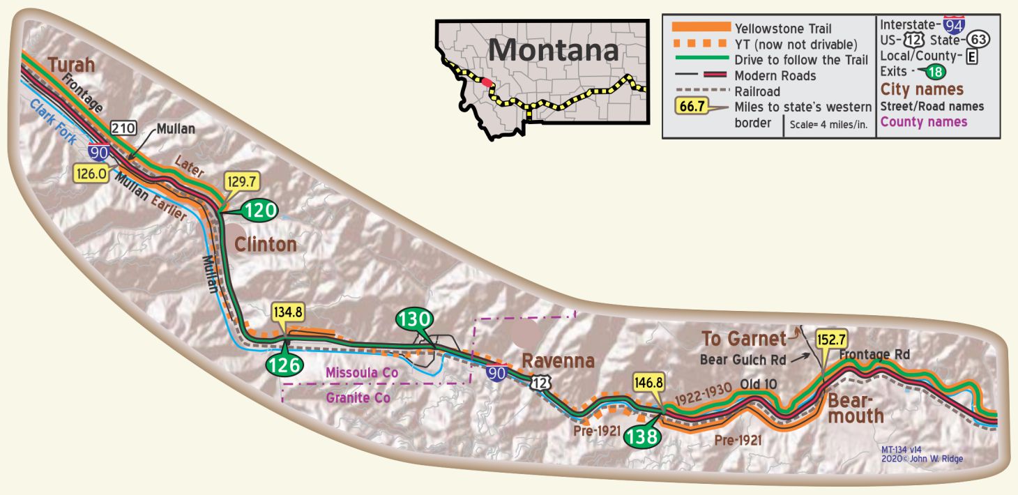 It is hard to believe, but the Mullan Road and Yellowstone Trail were carved out of these hills near Turah. Today, you see a slightly re-routed Clark Fork River, made to provide more land to accommodate I-90. A dim route along the side of the hill is visible on Google Earth. This picture gives an idea of the road-building problems of 100 or more years ago in the West.
MT-129.7 Clinton
A scattered village. Good meals and rooms at Clinton Hotel; very fair garage. MH-1928*
MT-134.8 Bonita
Gas and oil at small store. MH-1928
The name is Spanish for “beautiful” named by Mexican Northern Pacific Railroad workers.
MT-146.8 Bearmouth Chalet
At mile 152.7 (no Interstate exit at Bearmouth) turn north on Bear Gulch Road to ghost town Garnet. As you turn north you will see the historic Bearmouth Chalet and campground. This area has been the site of rest and supply camps for gold prospectors for over 100 years.
MT-146.8: East of here is a very nice drive. As is true for much of the YT, it is hard to tell exactly where YT was before the new cuts and realignments.
MT-163.8 Drummond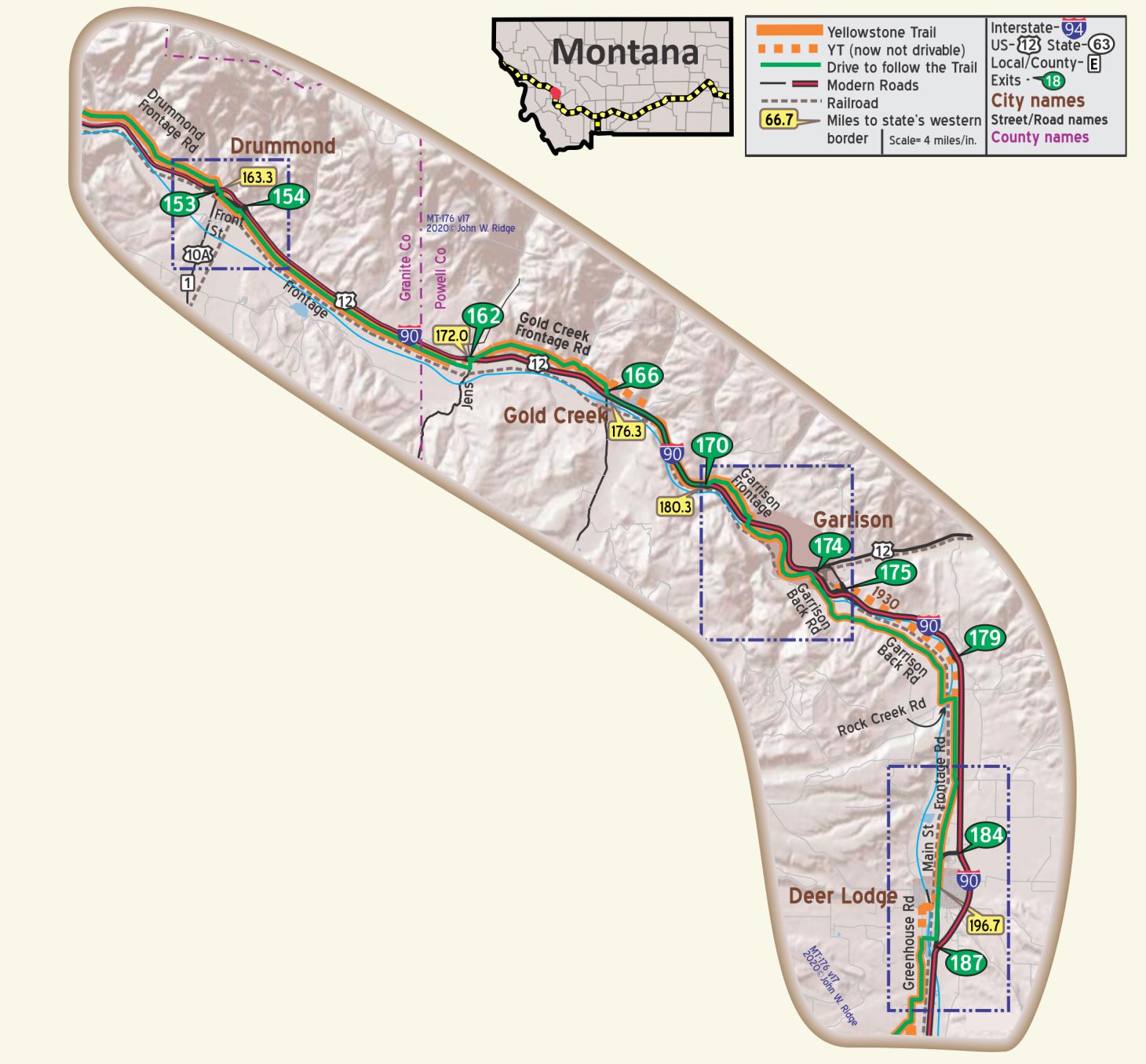
Notice the fantastic grey cliffs along the road. They are Madison Limestone, a rock made up of fossilized remains of countless marine creatures deposited in a shallow sea about 350 million years ago. The tree line across the sides of majestic mountains is quite clear here.
“The town looks much the same today as it did in the 1920s. Some structures remain from the 1880s,” says the Philipsburg Territory, “steeped in the tradition of the ranch.”
The town has been a shipping point for dry goods, mine ores, and cattle from Granite County for well over 100 years and still ships cattle and hay today. As you travel down Front St., the Yellowstone Trail, notice the south side of the road at the east end of the town the cattle-holding pens and the great sign, “Used cow lot.” Drummond is also known as the home of the “World Famous Bullshippers.” This should tell you that you are in an authentic western community, famous as a cattle shipping point and with a sense of humor!
New Chicago School House Museum (GPS: 46.67148, -113.15049). Built in 1874, the school building was moved from its first location at New Chicago, seven miles south of Drummond into the west side of Drummond next to I-90. The museum offers a number of exhibits giving the visitor a glimpse of the history of Drummond and this area.
MT-185.1 Garrison
(4,344 alt., 100 pop.), named for William Lloyd Garrison, abolitionist, is a railroad town on the Clark Fork, sheltered on the north by a high bluff. WPA-MT*
A Phosphate Mill of 100 tons capacity grinds rock of high phosphate content brought by truck from several small mines in the nearby mountains. The product is used for fertilizer. WPA-MT*
There once was a lovely Pratt truss bridge spanning the Clark Fork River which carried the Yellowstone Trail since 1914.Today that condemned bridge rests in the Deer Lodge Old Montana Prison Museum back yard, saved from demolition by the Powell County Museum and Arts Foundation. It will be used as a pedestrian bridge connecting walking trails.
MT-196.6 Deer Lodge
(4,530 alt., 3,510 pop.), seat of Powell County, is bisected by Clark Fork of the Columbia, here called the Deer Lodge River. On the west side of the town are the somber stone walls and guard towers of the State penitentiary, and the yards and shops of the CM. St. P & P R.R., the town’s leading industrial unit, which employs 250 men. On the east side, which has broad streets, are many sturdy square houses popular in the West during the 1870s and 1880s. Castles built with the wealth of mines and ranches and log cabin homes survive almost side by side. An important stop on the Mullan Wagon Road, it was one of the few places along the route where immigrants could obtain fresh beef and vegetables, and the services of a blacksmith. WPA-MT*
HOTEL DEER LODGE well furnished and modern; elevator service. Sgl. $1.50-$2.50; dbl. $2.50, with bath, $3.25-$3.50. MH-1928*
There are at least five museums in the Deer Lodge Old Montana Prison Museum complex:
1106 Main St. (Yellowstone Trail). Old Montana Prison Museum (yes, a real historic prison with guard turrets). The castellated red brick cell block was built in 1912. Under Warden Frank Conley (1893-1921) prison laborers built most of the buildings that visitors see today.
1106 Main St. Within the walls of the old museum. Montana Auto Museum. Over 160 cars are on display from classic cars to muscle cars.
1107 Main St. Frontier Montana Museum features tools, rifles, Conestoga wagons and necessities of frontier life.
1017 Main St. Yesterday’s Playthings gives visitors the feeling of stepping back into another time where the Railroad ruled, and of mining, outlaws, and toys of “yesterday.”
1117 Main St. Powell County Museum featuring local history. Experience what life was like in early Montana.
Here also is the old 1912 Garrison bridge. The “Iron Lady” would have been destroyed if not saved by the Powell County Museum and Arts Foundation and lodged in the Prison Museum’s back yard.
The 1912 Conley Street Bridge across the Clark Fork River once carried the Yellowstone Trail past the prison and along the Milwaukee Road tracks. At this writing the bridge is being reconstructed and we do not know how much of the original will be left, if any.
At the end of the bridge toward the railroad tracks is a small building with original Yellowstone Trail yellow signs “L” and “R” painted on the building indicating to Trail travelers which way to go to remain on the Trail. The two signs were preserved in plastic the last we knew, but they may be disintegrating.
As of this writing, the 1911 Deer Lodge Hotel had been taken over by Deer Lodge Preservation, Inc., a non-profit corporation, which is attempting to restore it to its 120-year-old glamour as being “one of the finest in Montana with hot and cold water in every room.” Fund-raising and volunteer work has been going on since 2014 and they were still looking for investors.
418 Main St. Rialto Theatre. The Rialto was constructed in 1921 in the Beaux-Arts “Movie Palace” architectural style, with 720 seats. A disastrous fire struck in 2006 burning the building substantially. The whole community immediately joined together to rebuild this city landmark and in 2012 it reopened, looking virtually the same, including its sparkling white exterior. It is home to the active non-profit Rialto Community Theatre, Inc.
266 Warren Ln. off Main St. At the northern edge of Deer Lodge is Grant-Kohrs Ranch National Historic Site, operated today as an 1880s working ranch by the National Park Service. Original home, furnishings, and horse-drawn equipment can be seen. This large 19th century range ranch illustrates the development of the Northern Plains cattle industry. It provides a glimpse into the real life of cowboys and ranchers.
MT-206.7 Racetrack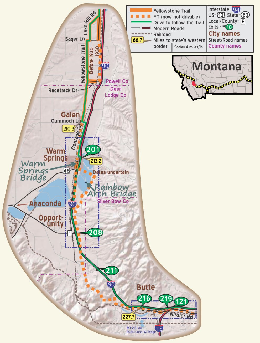
About 10 miles south of Deer Lodge near the Powell County/Deer Lodge County line on the Yellowstone Trail is a place called Racetrack.
Racetrack, Montana, was so named because the flat land lent itself to horse racing, popular in Montana’s history. Copper King Marcus Daley housed and trained his horses in Hamilton, Montana, but participated in races throughout Montana and the nation. “While horse racing in Montana became big business, the industry’s roots were planted first in communities like Virginia City, Deer Lodge, and Helena during the 1860s,” wrote Ellen Baumler in the Helena Independent Record.
As you travel south on the Yellowstone Trail at Racetrack area, look west at the junction of Racetrack Dr. At 931 Racetrack Dr. was the Log Cabin Bar. For 116 years it stood, a cool place of refreshment for the area ranchers, prison personnel, and Yellowstone Trail travelers. When we were last there, the dark interior was a pleasant respite from the glaring summer sun. Owner Mary Harrington wanted to retire so it closed in 2006. Today it is called the Gem Bar and Store. We have no details to offer.
MT-210.0 Galen
At Galen, a TB sanitarium was built in 1913. That site is now used for mental health patients.
MT-213.2 Warm Springs
Named for the hot water springs on the campus of the State Hospital for the insane built there in 1895. The springs have built up a tower of limestone 40 feet or more. The original buildings have been razed, and new buildings on the site house civil court commitment clients.
There is a 1912 concrete bridge used by the Yellowstone Trail straddling Warm Springs Creek. From the south exit I-90 at Exit 201, follow Garnet St. west, then Mt. Evans Way to the south. From the north keep on the frontage road at Warm Springs and turn west at Garnet St. A short distance later, turn south at Mt. Evans Way. A short distance later you will be on a small bridge. Satellite views show a faint path of the old Yellowstone Trail which ran over this bridge. You will not be able to see the bridge from the Frontage Road because of the many trees. That bridge was built by convicts from the state penitentiary at Deer Lodge during a period of great use of convicts as an economical move. It is rather a plain bridge with no markings except for the date “1912” at the end of one guardrail.
About mile #203 on the Interstate (which you must drive on to get to Butte) look to the east. It is hard to see, but a bridge is visible looking like it is on an island in the middle of Settling Pond #2 of the old Anaconda Mining Company. The bridge was built to join the Milwaukee Road Morel Substation with Anaconda. See History Bits for more information.
MT-236.4 Butte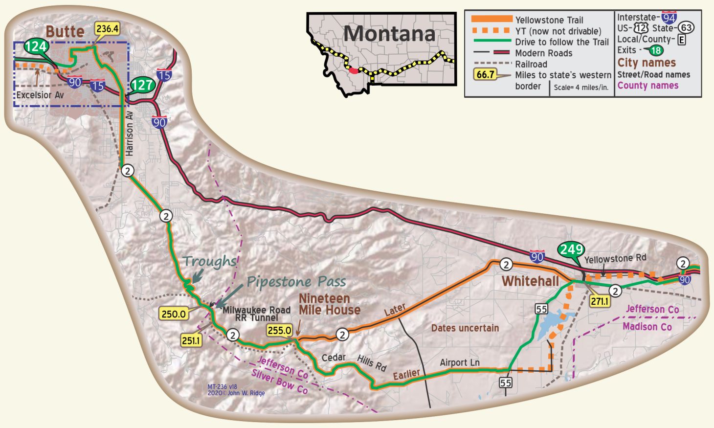
(pop. 40,000 alt. 5,484 ft.), is the foremost mining center of the world. In 1864 an outcropping or ledge of mineral was discovered, which has since developed the world’s greatest deposit of silver, cooper, and zinc and made the Anaconda mine famous the world over. Since the time of its location, twelve hundred million dollars in minerals have been taken from this hill, and from the lowly little western mining camp, Butte has grown until today it stands the largest city between Minneapolis and Spokane and the leading business and railroad center of the Rocky mountain northwest. BB1921-9*
HOTEL FINLEN finest by far and fireproof. All rooms outside and with toilet. Sgl. $2-$4; dbl. with toilet $3-$3.50, bath $4.50-$6; lunch 75e; dinner $1.25; coffee shop.
ARIZONA HOTEL location detracts but second best account being fireproof; nearly new, well furn.; good values. Sgl. $1.25-$2.50; dbl. $1.50-$2.50, bath $2.50-$3.50.
ACOMA HOTEL small but well kept; outside rooms best; good beds. Sgl. $1.50-$2.50; dbl. $2.50, bath $3.50.
PATTERSON MOTOR CO. 209 S. Mont. St., is well equipped; does fine mechanical work. Labor $1.65. Ph. 477.
CRAWLEY MOTOR SUPPLY CO., 220 E. Broadway. Outstanding for tires and accessories. Drive-in shop; highly efficient tire service; complete stock. Ph. 661 until 6. Mohawk Sealer. MH-1928*
Butte was not so much a “melting pot” of nationalities; it was a “tossed salad.” Each nationality was distinct from others in separate neighborhoods and customs. But they all had an interest in surviving as miners.
This mining city of immigrants sat on top of a Boulder Batholith, a vast block of granite, rich in copper, gold, silver and zinc. No wonder the place was called “the richest hill on earth.” We do not call attention to today’s obvious tourist attraction, the huge toxic, water-filled Berkeley Pit, because it was not there 100 years ago for Yellowstone Trail travelers to see. The open pit mine began operations in 1955. It was the 200 mines that made Butte and gave it the heritage celebrated today. Many “head-frames” can be seen today marking the remnants of mines that honeycombed the Butte hill.
219 W Granite St. Copper King Mansion. William Clark, one of the three Copper Kings of Butte, became a U.S. Senator and “one of the 100 men who owned America.” At a cost of $240,000, it is a massive and opulent home in every way. Although it is a B&B now, it is still open to the public for tours.
17 W Mercury St. Mai Wah Society Museum. This Chinese museum might be overlooked by the tourist because of the building’s unprepossessing appearance. Housed in the historic Wah Chong Tai Co. and Mai Wah Noodle Parlor buildings, the museum explains the Chinese experience in Butte. Original furnishings and Asian merchandise are present.
20 W Broadway. (Yellowstone Trail). Piccadilly Museum of Transportation. From the quirky name of the establishment to the eclectic interior, this is a one-of-a-kind transportation site with advertising art and memorabilia from around the world. Even old cars.
50 W Broadway. Legatt Apts. Started as Legatt Hotel in 1914. It has been fully fireproofed, as the large sign on its exterior wall says, and is still going, for over 100 years, as a residence.
155 Museum Way (next to Montana Tech campus) World Museum of Mining. Twelve acres of outdoor and indoor displays built on a 100-year-old silver and zinc mine site. The underground mine tours should not be missed. The museum also depicts the historical legacy of mining and the culture of Butte.
316 W Park St. The Mother Lode Theatre. It was built in Butte’s cultural heyday, 1923, as the Temple Theatre by the Masonic Order adjacent to their six-story building. It was restored in the 1980s as the beauty it is today.
100 E Broadway St. (Yellowstone Trail). Finlen Hotel. Opened in 1924 and updated in 2016, it still is a fine boutique hotel with elegant architecture and decor. It’s right in historic downtown Butte “where Copper Kings have slept,” says their ad. The January 24, 2018 Missoulian reported that “The Finlen Hotel, opened as one of the most elegant hotels between Minneapolis and Seattle.”
220-236 E Broadway. Broadway Garage. In Yellowstone Trail days this garage served drivers well, repairing what damage the poor roads inflicted upon the family buggy. Looking today just as it did almost 100 years ago, it now serves as a popular vehicle storage building.
117 S Main St. Pekin Noodle Parlor. A 108-year-old Chinese restaurant, currently owned by the Tam family, is still serving food in the heart of Butte’s Chinatown. The game of Keno was said to have been invented in the lower level of the upstairs restaurant. Each table is secluded from others by walls and a curtain. After we were served, the curtain was closed in our cubicle to afford privacy (whether you want it or not). The rumor that the cubicles were once occupied by prostitutes is false.
9 N Main St. The M&M Cigar Store was opened in 1890 by Sam Martin and Wm. Mosby. “This is Butte’s one remaining cigar store from Butte’s days as a ‘wide open town’ when drinking parlors sold cigars to cater to working miners off shift,” says the Copperway Walking Tours. Actually it was a 24-hour-a-day drinking and gambling bar. The “cigar” title was in deference to Prohibition. It has had a rocky time with several changes of ownership. We have been surprised lately that the place that advertised “it never closed” was closed. Presently, it is open but, as expected, is updated from the character of the “old days” in looks, menu, and hours. Some old codgers are sad; some folks are just happy that this historic icon was not razed.
This just in. Late at night May 6, 2021, and into May 7 fire gutted the famous icon – The M&M. Donations are flowing in to rebuild this beloved Butte fixture. The neon sign was saved.
Following I-90 to the east takes one through exfoliated rocks and the “singing rocks” in Town of Pipestone.
MT-250.0 Pipestone Pass
This mountainous pass crosses the Continental Divide. This was the Yellowstone Trail’s route, then it was US 10 in 1926. Today, I-90 is routed through nearby Homestake Pass with its easier curves, leaving this fine route for slower autos with views of the Beaverhead-Deerlodge National Forest from its 6,347 foot elevation. You may still see an ancient ad for a Butte taxi company painted on a rock near the road.
This road was known locally as Harding Way in honor of visiting President Harding (1921-1923). This road marks the juncture of the Yellowstone Trail and the Vigilante Trail.
The Milwaukee Road used the pass for its crossing of the Continental Divide, cutting under the Pass in a tunnel. The line was electrified in 1915 and was abandoned in 1980.
Keep your eyes open on the north side of the Pass for old watering troughs along US 2. The fountains provided drinking water for travelers and water for overheated auto radiators. They were recently maintained by the Heinze family of Butte; there is no water available now.
Western Tourism Magazine, Fall 1923 describes “The Continental Divide Through Montana” and says: “The Yellowstone Trail … is making the Continental Divide area of Montana a new summer playground. Harding Way, the much-traveled crossing of the Great Divide at the front door of Butte marks the juncture of the Yellowstone and Vigilante Trails.”
MT-271.1 Whitehall
pop. 600; a farm and stock center. Three modern hotels. Modern Hotel [Borden’s] is good. Free camp.
PALM HOTEL well kept; fine meals. Dbl. $1.50-$2.
TAIT’S GARAGE is far best. Almost every service. Labor $1.50; ph. 35; 24-hr. towing. Mohawk Dealer. MH-1928*
(4,371 alt., 553 pop.), is a long, narrow, quiet town, the trading center for the southern part of Jefferson County, one of the original Territorial counties. It is apparently merely a line of stores and houses strung out along US 10, but actually, most of it sits back among shade trees and shrubbery. The number of settlers in the region increased slowly but Whitehall did not have much importance until 1889 when the Northern Pacific branch between Logan and Garrison was built. WPA-MT*
Twelve murals depicting Lewis and Clark’s travels through the area adorn downtown buildings.
The main drag of Whitehall, Legion St., was close to the railroad tracks, as was usual in western small towns. However, a small space was left between the tracks and the street. This space was grassed and turned into a “tourist camping grounds.” Today that long narrow space (the length of the downtown) serves as a beautiful boulevard park and picnic area with many trees, enhancing the town immeasurably.
303 S Division St. Jefferson Valley Museum is housed in a renovated 1914 red barn of the old Sanitary Dairy located three blocks south from the middle of Whitehall. Look for a sign at corner of Legion and Division. The museum features artifacts depicting the history of the Jefferson Valley area. Retired Director, Roy Millegan, brought forth an excellent and enduring picture of Jefferson Valley and personally guided us along the Yellowstone Trail in the area some years ago.
101-105 W Legion St. (Yellowstone Trail). Borden’s Hotel. Borden’s pool hall, café and dance hall were expanded in 1916 into a hotel. Today, after a $1.5 million renovation in 2015, there are nine apartments and two rentals, a conference center and businesses on the lower floor. Of course, there is the persistent rumor of the ghost of Mrs. Hilda Borden ambling about. It is on the National Register of Historic Places.
MT-278.3 – 1929 YT Intersection Earlier Route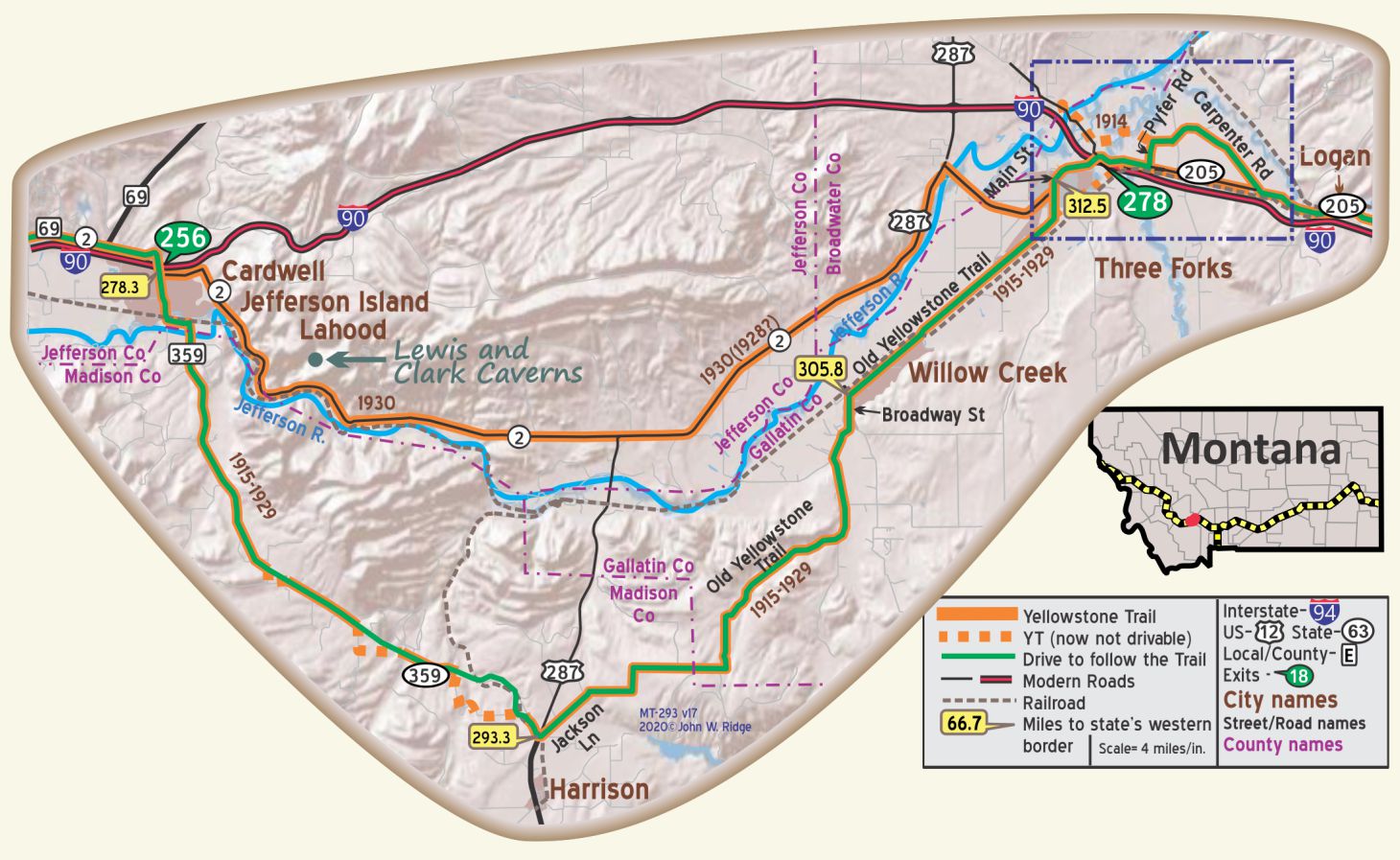
At this location, near I90 Exit 256, MT 2, the 1929 Yellowstone Trail intersects the earlier route. The green “driving line” is marked on the older route because of its more historical experience but MT 2 goes through LaHood and the Jefferson River gorge and past the Lewis and Clark Caverns. The gorge runs through fossil-ridden limestone with an occasional hillside cave on the north side and meandering railroad tracks and the Jefferson River on the south side. Beautiful, actually, with National Forests all around.
WAYSIDE! Lewis and Clark Caverns State Park.
25 Lewis and Clark Caverns Road, about 14 beautiful miles east of Whitehall on MT 2, the 1930 route of the Yellowstone Trail. Lewis and Clark Caverns overlooks the trail of Lewis and Clark along the Jefferson River.
Having been discovered in 1882, the cave was first developed for tours around 1900 and officially named by Teddy Roosevelt. It is Montana’s first state park. It features one of the largest known limestone caverns in the Northwest which is lined with stalactites, stalagmites, columns, and helictites. Although Lewis and Clark never saw the limestone cavern, they did pass through portions of the modern day 160 acre monument park and the nearby Jefferson River.
The cavern equals the well-known Luray caves of Virginia.The entrance to the cave is locked and the keys are in the custody of the chief of the field division of the general land office in Helena, Mont. BB1921-9*
The full journey requires vigor, sure-footedness, and a readiness to cling and sometimes to crawl by the light of a miner’s lantern. The air is good. WPA-MT*
MT-280.1 Jefferson Island
pop. 50; a shipping point; mechanic at store.
Lahood’s camp, 50c, is popular. Fine community house; dining hall. 4 clean cabins, $1.25-$1.50. MH 1928*
WAYSIDE! Shadan LaHood of Syria opened a mercantile business in Jefferson Island. He was a model citizen and, for some years after 1909, ran a general store. He was a booster of the Yellowstone Trail and provided services for tourists. Then in 1929 the new highway, now MT 2, was opened between Three Forks and Whitehall. It bypassed Jefferson Island.
LaHood bought land along the new route and built a hotel, cafe, and service station to serve the tourists coming through the Jefferson River Canyon to the Lewis and Clark Caverns. The area became known as LaHood Park. It prospered through the 1930s and in 1936 Frank Bliss painted a unique depiction on the four wood panels under the canopy which protected the fuel pumps. He drew a map of the entire Yellowstone Trail from coast to coast, giving it the U.S. highway numbers current in 1936. The site closed after LaHood died in 1957.
Unfortunately, the site burned down in 2001.
MT-293.2 Harrison
WAYSIDE! Norris Hot Springs
Norris Hot Springs is 11 miles south of Harrison on MT 84 and MT 387. Geothermal hot springs feed the pools here. Casual and family-oriented, open all year, soak your bones in a wooden pool.
MT-305.8 Willow Creek
All we have to say is watch out for the gumbo on the old Yellowstone Trail on the “Harrison Hill!” After 100 years, it is still sticky and rolls up around tires and gets so thick that it will stop cars.
The initial 1867 survey point for the state of Montana is located on Old Yellowstone Trail, a few miles south of town. A historic marker signifies the spot. Gumbo was just as bad on this side of “Harrison Hill.”
WAYSIDE! Parker Homestead State Park.
Eight miles west of Three Forks is a frustration. On this one-acre space is a preserved sod-roofed cabin built in the early 1900s. It was similar to many of the first homes built by early Montana settlers and was the smallest park in the state. We visited it every time we passed by. We walked right up to it and peered into the interior. Unfortunately, the state park commission let the lease expire, and in 2010 the homestead reverted to private ownership. It was still standing when we last visited it, but you must view it from the road.
MT-312.5 Three Forks
SACAJAWEA HOTEL two floors modern; attractive and well managed. Sgl. $1.50-$2.50; dbl. $2.50, bath $3.50.
AVERY GARAGE well equipped; open 24 hrs. Ph. 25. MH-1928*
YELLOWSTONE TRAIL GARAGE. Gas, oil. Labor $1.25/hour. MH-1926*
Three Forks is a very interesting town geographically and historically. It has long been known as the “headwaters” of the Missouri River and as the home area of Sacajawea and it is here where many Native American battles were fought and colorful legends were born.
Go to Headwaters Park to view the three rivers (Jefferson, Madison, Gallatin) become one (Missouri).
202 S Main St. (Yellowstone Trail). Headwaters Heritage Museum. Thousands of artifacts are housed in this former 1910 bank building relating to important moments in Western history.
302 S Main St. Masonic Temple. The building still stands, first as a bank with the Lodge upstairs in 1909. Various banks occupied the lower floor over the years and the 1925 earthquake destroyed the stonework around the eaves of the building, but the Masons are still there. Don’t let the boarded-up windows fool you.
5 N Main St. Sacajawea Hotel. It was built by the Milwaukee Road as a hotel for railroad men in 1882 and moved to its present site and expanded in 1910 to serve as a jumping off point for tours to Yellowstone Park. The Hotel has risen from a low point closure in 2001 to today’s premier status. A member of Historic Hotels of America and recipient of the 2011 Historic Preservation Award of Excellence, the elegant Sacajawea Hotel was, no doubt, used by Yellowstone Trail travelers.
Across the road from the Sacajawea Hotel is a recently moved railroad station. Interesting history and project. Ask locally.
MT-320.0 Logan
LOGAN, a N. P. R. R. freight division point. Good country hotel; very fair garage; open camp space. MH-1928*
 MT-325.5 Manhattan
pop. 700; a farm, stock and sugar beet center. Auto Inn Garage leads. Camp, 50¢.
METROPOLITAN HOTEL good rooms and meals. MH-1928*
(4,258 alt., 501 pop.), is a one-street town with a few business buildings facing a tree-enclosed park. It was named by a group of New Yorkers who operated under the name of the Manhattan Co. and owned land here. The George Sinton ranches, one of the largest cattle spreads north of Texas, has headquarters here. WPA-MT*
105 S Broadway. Manhattan Area Museum and Historical Society. “The Manhattan Area Museum serves to preserve and make available for study and research the history and culture of the area,” says their website. We stopped in; it is small but interesting.
114 E Main St. (Yellowstone Trail). Manhattan Auto Inn. A 1915 auto garage used as an auto storage and repair garage in Yellowstone Trail days. Today it is a mixed-use space with a bar in front and event space in the rear. The building was noted because it was made of concrete and “had no supporting posts on the floor.” A similar garage with “no supporting posts” was built in 1914 in nearby Belgrade, Montana.
MT-335.6 Belgrade
(pop. 800, alt. 4,437 ft.), is centrally located in the great Gallatin valley, made world famous by its many prize winning products as well as by its scenic grandeur. The Belgrade Chamber of Commerce has provided camping facilities at Athletic park for the free use of tourists. BB1921-9*
ELECTRIC HOTEL modern and good. Dbl. $2, bath $2.50.
FOERSCHLER GARAGE leads. Progressive and well equipped. Labor $1.25. Ph. 54W.
HESPEN TIRE AND BATTERY SHOP gives a skilled service and is unexcelled. Ph.11-J. MH-1928*
27 E Main St. (Yellowstone Trail). Mint Bar and Cafe opened in 1904; claims to be one of the oldest continuously run establishments in Montana. Its neon sign looks 1930s. It has had multiple incarnations, but now blends modern with classic western. Live music of every modern stripe. Yellowstone Trail travelers may well have frequented the place 100 years ago.
MT-345.7 Bozeman
pop.10,000, alt. 4,754 ft. is commonly termed “the Egypt of America.” It is one of the great flour and cereal milling centers of the state. The Montana state agricultural college is located there. There are 13 beautiful canyons within a short drive of Bozeman. At the mouth of the Bridger canyon is located the government fish hatchery where millions of fish are hatched and transferred to the local streams. Bozeman has a splendidly equipped camp for auto tourists. BB1921-9*
BOZEMAN, (6,855 Pop) is, for Montana, an old and decorous town. Local ordinances prohibit dancing anywhere after midnight and in beer halls at any time, it is illegal to drink beer while standing, so all Bozeman bars have stools. WPA-MT*
BYRON’S CAFE is best; lunch 40c. Gilkerson Cafeteria is liked. Bozeman Camp, 50c, good.
BOZEMAN HOTEL is largest; 100 outside rooms. Sgl.$1.50-$2.50; dbl. $2.50, bath $3-$3.50.
BOZEMAN AUTO CO., Buick; best general garage and finely equipped. Very large stock replacement parts. Labor $1.50. Ph. 168, after 9 ph. 775-W.
MAIN ST. GARAGE, 24-hr. mechanical work; storage. MH-1928*
Bozeman is located on a beautiful site in the Gallatin Valley with the Gallatin and Madison Ranges to the south, the Bridger Range to the northwest, and the Absarokato Range to the southeast.
105 W Main St. (Yellowstone Trail). Baxter Hotel. “Built in 1929, the Baxter is a renovated, historic hotel in the historic district of downtown Bozeman. As you enter the lobby, you’re welcomed by marble floors, vaulted ceilings, warm lighting, and historic elegance. The Baxter no longer offers lodging accommodations, but “is home to fine and pub style dining, and residential and commercial rental spaces,” says their website. Latter-day Yellowstone Trail travelers may well have visited the place when it was a hotel.
17 W Main St. The Ellen Theatre. According to Montana’s Cultural Treasures, The Ellen Theatre “First opened in 1919 and was a favored stop on the vaudeville circuit featuring variety shows with stars such as Edgar Bergen. The Ellen also hosted symphony concerts, traveling operas, and starting in 1926, ‘talking pictures.’ Shuttered and abandoned for years, the Ellen was purchased and restored in 2008 … and now hosts a wide variety of programming from Broadway musicals to classic films …”
317 W Main St. Gallatin History Museum of Bozeman. Formerly called Pioneer Museum, it is in a 1911 former jail! In addition to jail cells and a hanging gallows, the museum maintains displays of local history, Native American history in the Gallatin Valley, relics of old Fort Ellis, 25,000 historic photos, and a Lewis and Clark research library.
600 W Kagy Blvd. Museum of the Rockies, located at the Montana State University (called the State Agricultural College in Yellowstone Trail days), is an affiliate of the Smithsonian. It houses a spectacular paleontology collection of dinosaurs and dinosaur eggs and exhibits of geology and Montana history. There are also a planetarium and a living history farm.
415 N Bozeman Ave. Beall City Park is a 2.2 acre park with an ice rink, grill and picnic tables, and Art Center available. We mention this park because it has been there from before the 1930s and would have been visited by Yellowstone Trail travelers.
Bozeman’s Main Street Historic District is located on either side of Main St., between Rouse Ave. and just west of Willson Ave., a four block area. As the traditional heart of commerce and culture in southwest Montana, the Main Street Historic District has a period of historic significance from 1867-1940.
811 S Willson. The 1910 Story Mansion is one of only three living examples of city-block mansions in Montana. Situated in Bozeman’s well-preserved BonTon Historic District, the Story Mansion is recognized as a Montana treasure and national landmark. T. Byron Story inherited a successful milling business from his father, Nelson Story. He expanded it, founded a canning company to can the 17,000 acres of sweet peas being grown in the area, and was a philanthropist, founding the Ellen Theatre, named for his mother.
The mansion is on the National Register of Historic Places.
 MT-371.9 Livingston
(pop. 7,200, alt. 4,487 ft.) is the gateway to the Yellowstone National park and is visited annually by thousands of tourists. It is just a pleasant auto drive of fifty miles from this city up the beautiful Yellowstone River valley. The town is picturesquely located on the banks of the Yellowstone river, which stream partly encircles the city. A free auto camping ground is maintained by the Chamber of Commerce a few blocks from the center of town. BB1921-9*
pop. 7,000; is the widely known and busy northern gateway to Yellowstone Park. Prospers also from the N. P. R. R. shops and trade from the territory north. Headquarters for elk, deer and bear hunting. Information at the live C. of C. The Grill is the best cafe. Park Hotel is popular. Yellowstone Camp, 50c, in fine grove on Yellowstone River; good kitchen; all conveniences; Many cabins, some very fine, with run. water, toilet and bath, $1.50-$2.
MURRAY HOTEL leads because most modern and only one fireproof. Sgl-. $1.50-$2.50; dbl. $2.50, bath $3.50-$5. Cafe.
GRABOW HOTEL is quietest; clean and well kept. Dbl. $2.25,with bath $3-$4. Café.
HOME AUTOMOBILE CO. is largest, most modern and best equipped. Open 24 hrs. Labor $1.50 or flat rate. Ph. 706 for wrecker. Mohawk Dealer. Telephone at ranch house. MH 1928*
A town with a history of western legends and cattle drives became gentrified but still maintains a Western atmosphere. Magnificent sights of four mountain ranges surround the city, and, bordered by the Yellowstone River, it became a tourist destination and locomotive repair and division site. The whole downtown and many homes are on the National Register of Historic Places, with buildings of the 1880s and ‘90s still standing, well preserved, as a testimony to the Old West.
Names from the past such as William Clark (of Lewis and Clark), John Bozeman, Jim Bridger, Calamity Jane, and Soapy Smith come as easily to the minds of residents as present-day movie stars who live in the area.
Corner of Park and Main. Livingston Bar and Grille, is a local restaurant, housed in an 1800s building which once housed the Bucket of Blood Saloon, a wild and raucous place back then.
118 W Chinook St. Yellowstone Gateway Museum of Park County. These folks know about the Yellowstone Trail. They told us about the rock slide on the Trail, blocking it for the foreseeable future. The museum features collections of Native American history, early transportation, mining, and Yellowstone National Park history. A gem is the only surviving tent of the many used by the Yellowstone Trail as portable travel bureaus to hand out literature in the 1920s. See the “Tally Ho” stage coach which transported Yellowstone Park visitors before autos were admitted to the Park in 1915.
200 W Park St. (Yellowstone Trail). Livingston Depot Center is in a restored 1902 Northern Pacific Railway station, turned into an historical museum after the Northern Pacific abandoned it in the 1980s. The beautiful Italianate building must have impressed passengers who arrived on their way to Yellowstone Park. The museum houses displays which examine the broader railroad history and the role the Northern Pacific played in the west. The museum also features an exhibit about the many films made in Montana. Listed on the National Register of Historic Places.
201 W Park St. The 116-year-old Murray Hotel still stands gracefully, offering 30 rooms or suites. Since its grand opening as an elegant railroad hotel in 1904, conveniently across the street from the Northern Pacific Railway station, the Murray has drawn a plethora of famous guests from Buffalo Bill and Calamity Jane to movie director Sam Peckinpah (in a suite for 7 years). Its antique furniture, marble lobby and staircase, animal heads on walls, oak doors, and watering hole bar are all redolent of 10 decades ago.
“Humorist Will Rogers and his buddy Walter Hill, must have been satisfied. They liked the place well enough that they tried to bring a favorite saddle horse to a third floor suite via the hand-cranked, 1905 Otis elevator. Celebrities have been stopping here for 90 years, rubbing elbows with the cowpokes, railroaders, and other travelers that provide a hotel’s life blood,” says their website.
109 W Callender St. Sax & Fryer. Known in Livingston since 1883, it has occupied this location since 1914. This purveyor of books and stationery carried our first book, Introducing the Yellowstone Trail. The place feels warm and inviting. Early Yellowstone Trail travelers may well have stopped here for picture postcards of the West.
229 River Drive E. Sacajawea Park. Although this park is fairly recent and not related to the Yellowstone Trail, we recommend a visit. The park features a lovely statue of Sacajawea on a horse with little Pomp. The park area honors the Lewis and Clark expedition because they camped at the Livingston site. The statue, created in 2006, marks the 200th anniversary of that famous trek.
 MT-390.0 Hunter’s Hot Springs
HUNTERS HOT SPRINGS HOTEL 150 rooms; many modern and good. A. P. $3.50-$5.50; E. P. Sgl. $1.50-03.00; dbl. $2.50-$4; with bath $5. Lunch 75c; dinner $1. MH-1928*
As you drive into the hot springs, it is hard to believe that a low wall of rubble and hard-to-find foundations are all that remain of a once major hotel complex. Here were excellent accommodations, food, glassed-in sun porches, a greenhouse and a hot water swimming pool fed by many springs. All for folks seeking Dr. Hunter’s mineral cures, and for recreation-seekers, beginning c.1870. The Yellowstone Trail Association met there in a pivotal session in August, 1914. The property has gone through several owners and purposes over the years, but one may still wander about and see a spring near the low wall of rubble. See Trail Tale: Hunter’s Hot Springs, page <?>.
MT-392.0 Springdale
This was a railroad station stop for people on their way to Hunter’s Hot Springs, two miles away. The Yellowstone Trail Association had a meeting at Hunter’s and it was a stop well-known to Trail travelers.
Just upriver of the Yellowstone River bridge at Springdale can be seen the footings of the old bridge used by the YT.
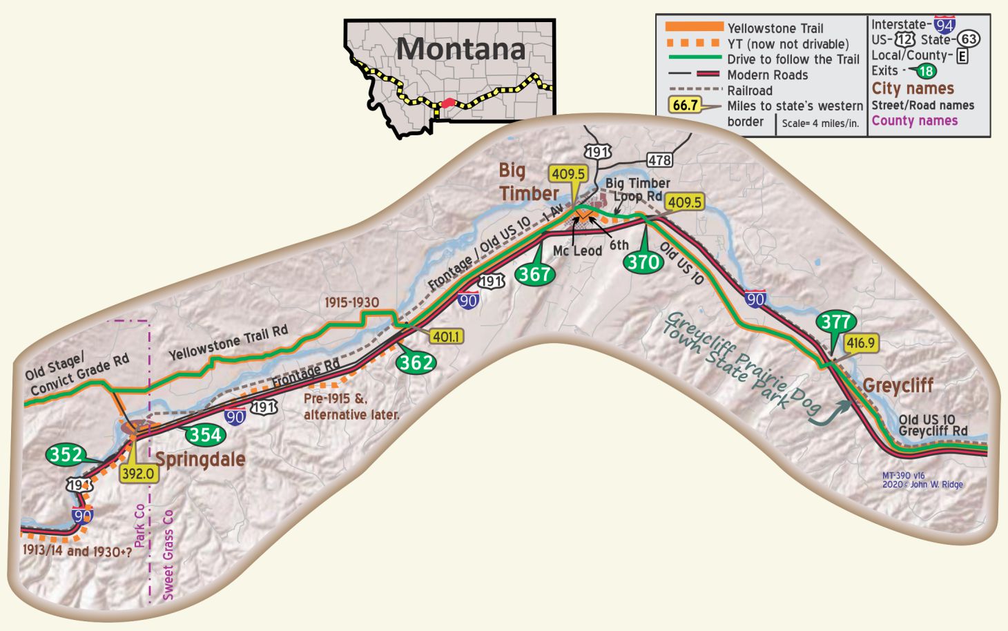
MT-407.2 Big Timber
pop. 1,000; located in sheep and cattle country; fine water. Best meals at Big Timber Bakery. Camp, 50c, east side of river in nice cotton-wood grove. GRAND HOTEL largest and best. Most rooms modern; good beds. Sgl. $l-$2; dbl. $1.50-$2; with bath $2.50.
MOTOR INN [garage] far best equipped; skilled and dependable. Labor $1.25; ph. 206K for wrecker any time. MH-1928*
Big Timber was an important wool exporting city in the late 1800s. Tourism is now a major contributor to their economy with tourists driving through to Yellowstone Park. The old US 10 (Yellowstone Trail) from Reed Point to Big Timber is very pleasant. If you are here in the autumn, note the heavy snow on the Crazy Mountains. Picturesque.
Many a Montana town lays claim to Calamity Jane. Restless Calamity apparently had a cabin on the east bank of the Yellowstone River here.
2 Cemetery Rd. (at I-90 Exit 367) Crazy Mountain Museum is located in a beautiful little glen with cottonwood trees, the Crazy Mountains to the north, and the Beartooths to the south. The museum displays western items such as chaps, sheep and wool industry items, and western archeology, but also a unique “Stabbur,” a Norwegian style cache to keep food from wild predators.
139 McLeod St. (Yellowstone Trail). Grand Hotel, now the Grand Bed & Breakfast. It serves lunch and dinner to the general public. Built in 1890, it’s still in business 130 years later. It got an overhaul in 2015 and the meal reviews are extraordinary, including ours. It is listed on the National Register of Historic Places “as an important center for social and commercial activity.” A fire in 1908 destroyed most businesses along McLeod St. but not the Grand Hotel which still maintains its frontier theme.
Adjacent to the north edge of Big Timber is the Yellowstone River Trout Hatchery (GPS: 45.83598, -109.96058).
In 1919, the Big Timber Rod and Gun Club raised money for purchase of land and donated it to the State of Montana to be used for the Big Timber Fish Hatchery. The State Fish and Game Commission had offered to initiate a small hatchery. Now called the Yellowstone River Trout Hatchery, it is the home of the Yellowstone cutthroat brood stock. Visitors are welcome.
1st Ave East is the Yellowstone Trail Garage. Now it serves as a substantial storage building.
An ad for this garage appeared in the 1914 Yellowstone Trail Association publication, First Year Book.
 MT-430.8 Reed Point
(3,767 alt., 158 pop.), The Absaroka Range is visible, tinted at sunset with rose and gold, its foothills touched with purple shadows cast by the Crazy Mountains. WPA-MT*
pop. 200. Center of a cattle and sheep raising country. Free camp space at river. Good rooms at small new hotel; De France’s Garage is good.
A splendid view of the high and wild Absaroka Mountain range over south. MH-1928*
After the bridge was built across the Yellowstone River to the north in 1911 at Reed Point, many people rushed to the area to acquire a homestead and begin sheep ranches. In a short time the town practically burst its seams. However, by 1920 the drought had caused the town to diminish measurably.
Last time we were there, the Hotel Montana and Wild Horse Saloon on Division St. was an abandoned shell. Too bad. That was an ageless, great piece of “real western” culture. On 209 Division St. the Waterhole Saloon – “Ain’t no city bar”- is still there, though. If the saloon wasn’t there 100 years ago, the building sure looks like it was. Featured on PBS and advertised as an authentic old wild west saloon, the horse trough and hitching posts certainly bear that out. Order a beer called “Moose Drool.” You’ll like it.
Sunday of Labor Day Weekend. “Great Montana Sheep Drive,” also called the “Running of the Sheep” recalls the old days. Hundreds of Montana-bred sheep charge down the four blocks of the main street. It also includes a parade, sheep-shearing contest and various sheep-beauty contests. First run as a spoof to the Montana Centennial Cattle Drive in 1989, it continues to draw big crowds.
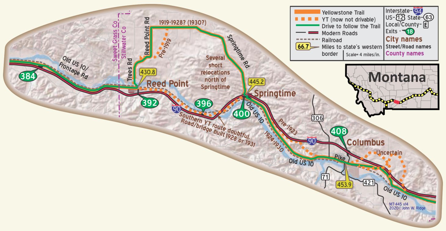
MT-453.9 Columbus
pop. 1,000; grain, sheep and cattle raising are chief industries.
Camping at Columbus Park 50c. hot shower; no shade; 7 very fair cabins $1.25-$1.50.
COMMERCIAL HOTEL modern; light and well-kept rooms. Sgl. $1.50; dbl. $2; with bath $2.50. Good meals 50c.
SCOVILL GARAGE leads. Modern and well equipped; labor $1. Phone 119W until 11 p.m. MH-1928*
(3,624 alt, 835 pop.) At the foothills of the Beartooth range, seat of Stillwater County. Lying between the large sheep and cattle ranches to the south, and the wheat farms to the north, it developed as a trade center and shipping point. WPA-MT*
440 E 5th Ave. (5 blocks north of Pike Ave.,Yellowstone Trail) Museum of the Beartooths. These folks know about the Yellowstone Trail, having hosted Trail speakers in the past. See their area history and artifacts of the Crow Nation.
528 E Pike Ave. (Yellowstone Trail). The New Atlas Bar. (Formerly just the Atlas Bar.) Opened in 1916, this old saloon doesn’t advertise. It doesn’t have to because the word of locals has kept it going for over 100 years. It “unquestionably possesses one of the most intact historic bar interiors in Montana,” said Jon Axline, State Preservation officer. It is called “the dead animal zoo” by some because of the many mounted animal heads. Visitors Lucky Lindy, Ernest Hemmingway, Mel Gibson, real cowboys, and real oldtimers “bend their elbows the same way.”
523 E Pike Ave. The Atlas Block. The east section was completed first and was initially used by the Columbus Mercantile Company. By December 1915, fraternal, civic and religious organizations held meetings on the second floor.
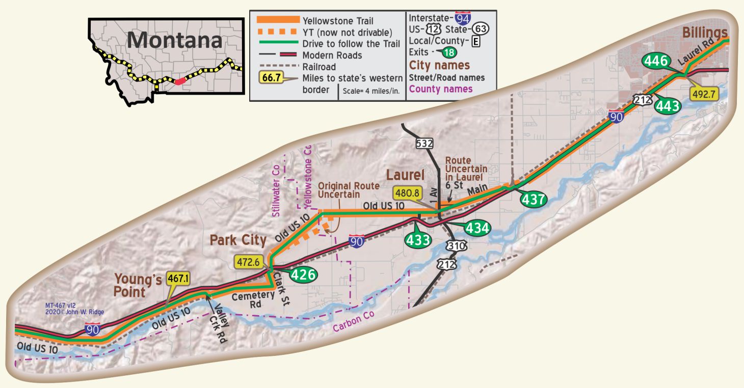
MT-472.6 Park City
pop. 200; free camp. The Trail garage is good. Rooms and meals obtained at Trewin Hotel. The sugar beet industry is outstanding in this vicinity. Best mechanic at Ebel’s Garage. MH-1928*
Named by settlers who planted trees there, the settlers rejected the Northern Pacific Railroad Company’s desire to place a station there, so Laurel was established as a major railroad hub instead.
MT-480.8 Laurel
YELLOWSTONE GARAGE is best. Good mechanics. Open 24 hours; labor $1.50; storage 50c; tel. 6, for wrecker.
MOBSMAN. Gas at store. Camp space.
Campo Camp 50c gas plates in kitchen. 15 single cabins with gas plates and garage $1-$1.25. MH-1928*
pop 3,000. Terminal of the Burlington, Great Northern and Northern Pacific Rlwys. N. P. shops employ 220; also a sugar beet center. Merchant Hotel has running water; dbl. $2.’ The Owl Cafe is good. Laurel Park Camp, pay shower; gas plates. MH-1928*
If you are going east, look about you at the last view you will have of the Beartooth Mountains.
If you are going west, here will be the first view you will have of the Rocky Mountains.
Roberta Cheney, in Names on the Face of Montana (Mountain Press 1984) said that “Laurel struggles on both sides of an intricate pattern of railroad tracks.” Three major railways, a large oil refinery, a large railroad roundhouse and I-90 now determine the profile of this historic town.
The south side of Laurel was once called “German Town” once settled by Volga River German immigrants. Their “Russian” homes are still standing and many have been restored.
Historic Main Street (Yellowstone Trail) has been renewed. There are 11 historic buildings on Main St. including the 1923 Block. Thirteen of the 16 historic sites on the walking tour of Laurel are on Main St., all of them are on the National Register of Historic Places. Take a walking tour offered by the Chamber of Commerce.
301 E Main. Site of the former New Yellowstone Hotel, now a bowling alley.
WAYSIDE! East Rosebud Lake.
This Wayside is further away (41 miles) than others, but the scenery and exploration
possibilities are worth the drive. Go south from Columbus on MT 78 to Roscoe, then take E Rosebud Rd. west to the lake. Approaching the lake is a bit problematical in that E Rosebud Rd. seems to end at a gated community. So explore a bit westward to find an unnamed road that leads you toward the lake. To say the least, it is a beautiful setting. The lake is about one mile long and one-half mile wide, 100 feet deep and at a 7,000 foot elevation. The road follows the E Rosebud Creek through a narrow valley among mountains in the Absorka-Beartooth Wilderness of the Beartooth Range.
A Mr. Wittam, Superintendent of the Beartooth Forest Reserve, wrote about the lake with lyrical language in the 1914 First Year Book. He opined that soon this beautiful area will be opened to all conveniences of civilization. “Chief among these is Rosebud Lake, which is a rival in beauty and grandeur to the far-famed Lake Louise of the Canadian Rockies. In 1911 an automobile road was built to this lake at enormous expense, making it possible to reach by a half-day’s trip from Billings. Cabins and a resort are being built now. Many trails will lead to the most beautiful places …”
Fortunately, Mr. Wittam’s optimism about “civilization” arriving was not borne out. Only a hard-to-find, unnamed road leads to the lake. The gated community is hardly a “resort,” but beauty, quiet, and solitude reign in this wilderness.
MT-496.5 Billings
It is the center of an irrigated and dry farming district, and its chief industries are the manufacture of beet sugar, packing house products, dairy produce, flour and building materials. Large oil, gas and coal deposits are located near by. BB1921-9*
NORTHERN HOTEL is best; All rooms light. Sgl. $1.50-$3.50; dbl. $2.50-$3; with bath $4-$5. Cafe in connection.
GRAND HOTEL is newest and fireproof; competes for first place. Sgl. $1.50-$3; dbl. $2.50;. with bath $3.50-$4.
LINCOLN HOTEL; modern, central, but quiet location. Has fine beds. Sgl. $1.25-$2.50; dbl. $2-$2.50,; with bath $3-$3.50.
WESTOVER GARAGE; best for wrecker serv. Ph. 6262. MH-1928*
Billings, named after a president of the Northern Pacific Railroad Company, still maintains its early history of cattle ranching and shipping. Boothill Cemetery, the Rimrocks and a huge oil refinery describe the rugged history of Billings.
Montana Ave. (Yellowstone Trail) from north 26th St. to north 22nd St. and north to 1st Ave. N is the Billings Historic District, the heart of old Billings. Since the sad condition of the area in the mid 1980s, Montana Ave. has risen like a phoenix from the dust through the efforts of many businessmen and preservationists.
2310 Montana Ave. The Northern Pacific Depot. From 1909 to 1979 trains rumbled and hissed to a stop here; at one time 26 per day from three railway companies rattled through. By 1914 almost 10,000 homesteaders alighted here and claimed land. The Depot building, one of four in the original complex, featured a spacious waiting area for 200 passengers, a gentlemen’s smoking room, and a ladies’ waiting room. The baggage area and waiting area are preserved. It was placed on the National Register of Historic Places in 1978.
2401 Montana Ave. Here is the beautifully restored buff sandstone and red brick turn-of-the-twentieth-century, small, Rex Hotel. After a close shave near a wrecking ball, the building was saved in the 1970s, upgraded several times, and expanded. The building was purchased in 2018; the owner planned to reopen the popular restaurant on the ground floor and to continue to rent the upper floors as offices.
2419 Montana Ave. the 1910 McCormick Hotel contains businesses at street level, but the hotel does not house travelers anymore. There may still be a “ghost sign” on the upper story of the building advertising McCormick Seeds. In Yellowstone Trail days W. H. McCormick took over his uncle’s seed company that became, probably, the largest seed house in Montana and is still a major seed/spice company today. W.H was a vice president of the Yellowstone Trail Association 1914-1915.
2501 Montana Ave. The Carlin Hotel, built in the 1910s and completely renovated recently, now offers extended stay lodgings.
2822 Montana Ave. Western Heritage Center is a regional history museum, an affiliate of the Smithsonian Institution. In the former 1901 castle-like Parmly Billings Library, the Center houses an education center, changing exhibits and a public archive. There are interactive exhibits, a western art collection, special exhibits and field trip tours. It’s a jumping place! And they know much about the Yellowstone Trail.
914 Division St. Moss Mansion Historic House Museum. Many original 1903 artifacts and elegant furniture from the P. B. Moss family can be seen year round; he was a prominent entrepreneur. It is an example of “the Golden Age” among the wealthy. It is on the National Register of Historic Places and was the backdrop for several films. The entry is Moorish and the dining room is Tudor. Eclectic! We have seen it and recommend it. You have an advantage over Yellowstone Trail travelers because they probably never crossed the threshold.
1950 Airport Terminal Cir. Peter Yegen Yellowstone County Museum. The original 1892 cabin entrance to the museum belies the 5,000 square feet housing 25,000 artifacts that tell the story of Billings. The museum has a Northern Pacific Railroad engine outdoors, and Native American and Western exploration displays. An observation platform offers magnificent views of the Beartooth, Crazy, and Bighorn Mountains.
See also a statue of “The Range Rider and His Horse” nearby at the airport. In 1927 the famous western movie actor, William S. Hart, posed for the statue, a symbol of the old cattle days in the Yellowstone River valley.
2313 1st Ave. N. Site of former Westover Garage. Charles Lindbergh worked there for a few months in 1922 as a mechanic. He also was a stuntman, jumping from airplanes over the Fairgrounds. Study the mural on the building (see bottom photo on previous page). Did you see the small airplane in it? See upper right panel of the mural.
2801 3rd Ave North. Alberta Bair Theater. Built in 1931, a year after the collapse of the Yellowstone Trail Association, it still is of the era. This spot was the homestead of philanthropists Charles Bair and his daughter, Alberta. The old theater was saved from “modernism” and returned to its 1930s art deco appearance and is a world class performing arts center featuring live music groups.
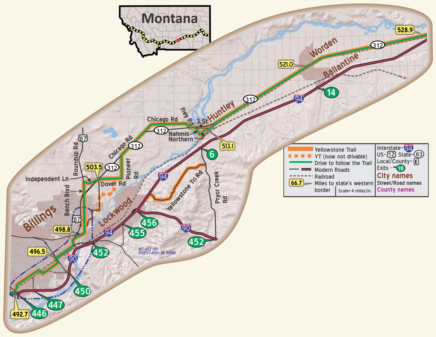 MT-505.1 Pioneer Elementary School
Corner of Dover and Pioneer Rds. (both the Yellowstone Trail). The 1905 school is still in use as a school today, accompanied by a 1960s addition and its placement on the National Register of Historic Places. Things have changed since the kids caught water snakes and frogs in the dirt floor coal room. Today grades 1-6 enjoy computers, a student-to-teacher ratio of 1 to 6, standardized tests and field trips.
MT-513.1 Huntley
770 Old Hwy 312 (Yellowstone Trail) 3 mi. E of Huntley. Huntley Project Museum of Irrigated Agriculture. On 10 acres, 18 buildings feature hundreds of turn-of-the-20th-century farm equipment pieces, a history of the 1907 Project, and artifacts that portray life on the Project to the late 20th century. It also displays the 1916 First National Bank of Pompey’s Pillar which closed in 1928 after grasshoppers and Mormon crickets decimated the crops at the start of the Great Depression. Joseph Cox tells the story in Project Overflight: One Family Looks Back at the Early Times on the Huntley Project (self published 1986).
Today, The Southern Agricultural Research Center, under the aegis of the Montana State University, maintains a research farm in 100-year-old barns near Huntley. See History Bits for more of the story of the Huntley Project.
MT-528.8 Pompey’s Pillar National Monument
Yes, we know that much has been written about this 1806 signature carved in this butte by Capt. William Clark of the Lewis and Clark expedition. We include it here because the Yellowstone Trail ran right past it well before I-94 did and Yellowstone Trail travelers, no doubt, stopped to view Capt. Clark’s signature 100 years ago. You’ll have to do a little stair climbing, though, to see it. Do stop at the stunning, visitor center.
 MT-531.5 Community of Pompey’s Pillar
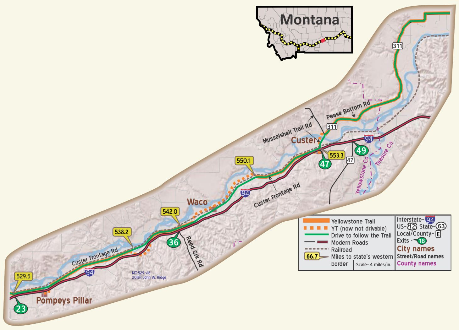
At MT-538.1 (GPS: 46.03103, -107.82426), the 1914 route followed “Old Hwy” to the east (leaving today’s Custer Frontage Road now on private land), running south of a lake and crossing I-94 several times, rejoining Frontage Rd at MT-540.5 (GPS: 46.03879, -107.80491).
MT-544.9 Waco
I-94 Milepost 41 between Exits 36 and 41 there is a wayside rest area which contains an interpretive sign about the Yellowstone Trail written by Jon Axline, Historian for the Montana Department of Transportation. It is a useful and pretty complete explanation of the Trail in Montana. Axline’s historic work has been displayed on many such helpful outdoor signs throughout the state.
MT-553.3 Custer
CUSTER, pop. 175; good home-cooked meals 50c at Park Hotel; also clean rooms. Sgl. $1; dbl. $1.50. Not modern.
YELLOWSTONE GARAGE does good work on all cars; open until 10 p. m. Road service. MH-1928*
The Great Northern Railway depot was being restored, the last we heard. The depot is located in the park.
MT-564.2 Fort Pease
As you leave Custer going east, you will be on MT secondary highway 311, the Yellowstone Trail. The road is also called Pease Bottom Rd., further east called Myers Rd. The little that is left of Fort Pease is on private property and is inaccessible. Just notice this nice drive to Myers.
Ranchers School is on Myers Rd. This white 1910 school still looks usable. It even has a bell tower.
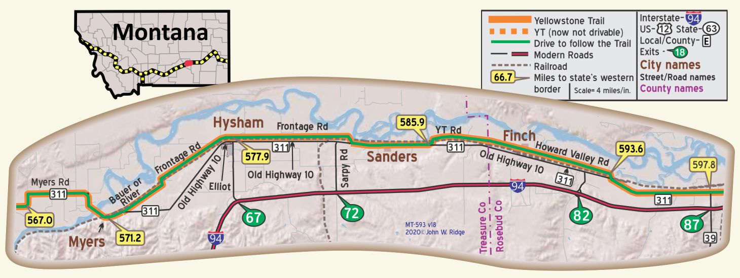 MT-571.3 Myers
About 2/10 of a mile west of the present Yellowstone River bridge near Myers can be seen the foundation of the 1914 Yellowstone River bridge.
MT-577.2 Hysham
Hysham pop. 350; a county seat town situated in a wheat, sugar beet and alfalfa section. Best rooms at Eureka Hotel. Hysham Garage has wrecker and is well equipped; labor $1.25. Free camp space. MH-1928*
US 10 now winds through lonely badlands. Under an uncompromising sun the sides of the buttes are mottled with brown, buff, and gray. After sundown, as twilight shades into dusk, the masses of guttered rock take on eerie tones of purple and black. Only the bark and scurry of prairie dogs by day, and the dismal howl of coyotes by night, indicate the presence of living things. WPA-MT*
Hysham has had a colorful history of cattle ranges, the Crow Indian Reservation, and 19th century forts and trading posts.
325 Elliot Ave. (Frontage Rd/Yellowstone Trail). Treasure County 89ers Museum. Pioneer history, and a display of Apollo 8 astronaut Frank Borman’s mementos of his trip around the moon and back are featured. The museum and the Yucca Theater across the street comprise an historical complex. .
324 Elliot Ave. The historic Yucca Theater, built in 1931, is Mission Style architecture, reflecting the grandiose style and flamboyant design of movie theaters during the 1930s. It has a white buffalo statue and statues of Lewis and Clark and Sacajawea and infant Pomp all in front of the theater. The last we knew, classic movies were shown on Sunday evenings in summer via a DVD player. Go look at the outside, anyway.The museum folks have the keys to the theater and if you ask nicely, they might let you see the inside
MT-593.6 Howard School
This 1904 clapboard school was expanded in 1916 when they expected more families from the 1909 Homestead Act and Mexican beet workers’ children. The fairly large school, for rural standards, served elementary through high school grades and even featured a chemistry lab. Later, an upstairs “teacherage” apartment was added. It appears to be in great shape and is used presently as a community center.
Howard School, 1904-1947, replaced a log one built in 1882. You will not find this school on tourist literature, but it is an important site on the Yellowstone Trail. It reminds us of the value placed on education in an era of great difficulty in acquiring education in rural areas. Students walked or rode horses up to nine miles to this school. A barn was built to house four or five horses during the day. A “teacherage” was included on the second floor, which was unique. Usually, a teacher was housed with the nearest farmer, as was the case with one of your author’s family. High school classes were also held on the second floor until a better road to Forsyth was built. “The community of Howard solidified around the school,” said the application for acceptance on the National Register of Historic Places. “… it showed the community’s confidence and investment in its future.” It serves as a community center today.
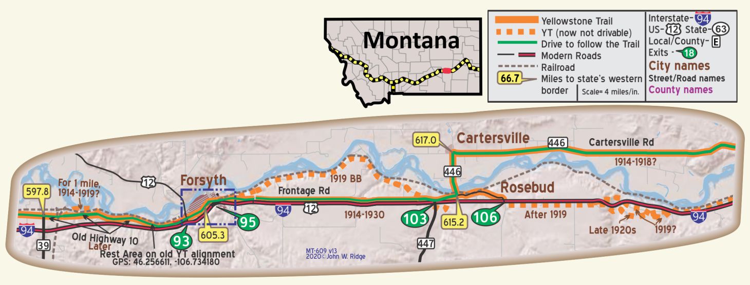 MT-605.3 Forsyth
pop. 2,000; a prosperous little railroad town in the center of a wheat and sugar beet area. Goodman Cafe is good. Tourist Camp 25c. MH-1928*
NEW ALEXANDER Hotel is best; nearly all rooms with running water. Sgl. $l-$2.50; dbl. $1.50-$2; with bath $3.50. MH-1928
SICKLER MOTOR SALES CO. is best for work on all cars. Open from 5:30 a. m. to 11 p. m.; labor $1.25 (lathe work $1.50); ph. 159 for tow car.
TEPEE MOTOR CO. is the Ford agency. MH-1928*
The Northern Pacific and Milwaukee Road railways created this commercial center, shipping its farm products and many head of cattle. Being along the famed Lewis and Clark Trail and the site of General Custer’s camp on his way to Little Bighorn Battlefield has given Forsyth a legitimate place in the history of Montana. Agate hunting is still a popular sport.
Main Street Historic District. Main St. (Yellowstone Trail) is a one-sided street, facing the railroad tracks. The town planners hoped to make a statement of progress for business travelers to see, back in the day.
1335 Main St. Rosebud County Pioneer Museum has a restored steam engine, early family collections, and western items. The museum is next to the historic (1913) courthouse with its stained glass, murals, and copper dome. It is on the National Register of Historic Places.
1195 Main St. Clark Hardware Co. This is a special place. Cal MacConnel, proprietor, has been a member of the modern Yellowstone Trail Association since its beginning and knows about the Trail in Forsyth. Stop in and talk with him. Better yet, examine his hardware store which features some vintage hardware items.
981 Main St. Roxy Theatre. “It’s a one screen theater in a small, quaint town. It’s like stepping back in time,” said a reviewer. From the Roxy’s website: “The Roxy Theatre (1930) has retained its old-fashioned charm, with the lobby, marquee and facade remaining mostly unchanged from when it was new. The auditorium has been modernized, and the booth contains modern equipment including digital sound.” We include it here because it was on the Yellowstone Trail during its last throes of life and could have attracted travelers on the Trail into the ‘30s.
807 Main St. Howdy Hotel, formerly the Commercial Hotel. Built between 1903 and 1906, it is a landmark on Main St. It sports huge “HOWDY” and “HOTEL” in block letters on the roof. And, for the century it’s been open, it’s stayed in the same family. Montana Historical Landscape calls it “a rare surviving small-town ‘booster’ hotel, built to impress traveling businessmen that Forsyth was a place of promise.” Obviously, the hotel has been upgraded over the years to meet modern expectations. There is still a barber shop off the lobby, just as in olden days. And their restaurant draws praise.
MT-616.2 Rosebud
pop. 200; sheep, wheat and sugar beets are the principal sources of revenue. Two garages.
Riverside Hotel has clean rooms. Fair Cabin Camp east. MH-1928*
The area has been described as a windblown grassy range, with piney slopes and treeless plateaus. Cattle and sheep grazed around yellowish buttes.
St. Philip’s Episcopal Church (Rosebud Community Chapel) is the oldest continuously operating log church in the state. Built in 1906, it has a long history of interfaith/community development.
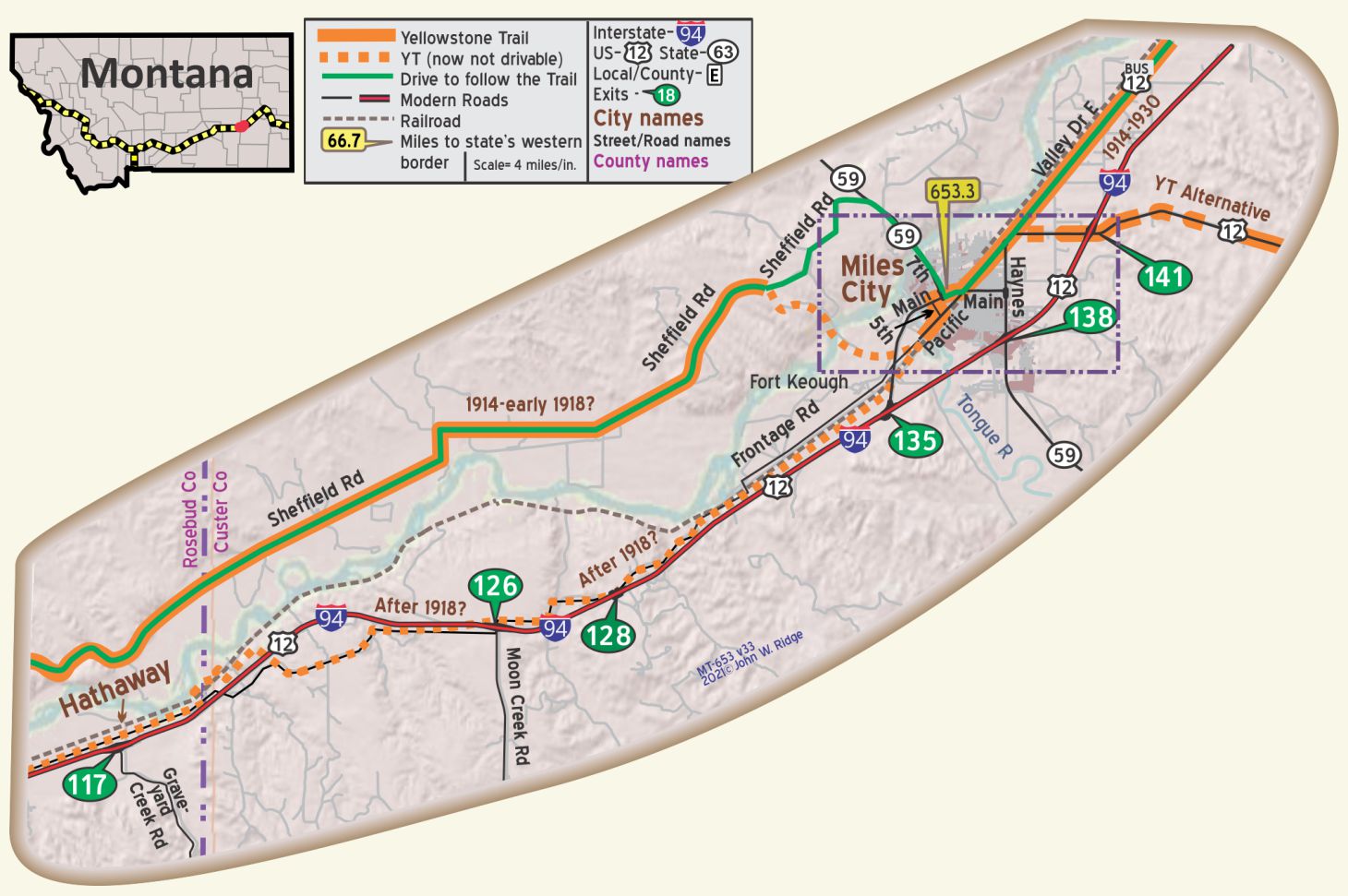 Fort Keogh
The site of the United States remount station is just outside of Miles City to the west. Thousands of horses are trained here for the cavalry and are sent to all the principal forts in the U. S. BB1921-92*
43 Fort Keogh Road, Fort Keogh Site
On the western edge of Miles City lies the site of Fort Keogh, built 1876-1877 and named for a captain killed in “Custer’s last stand.” It was commanded by Col. Nelson A. Miles, for whom the adjacent town was named.
There isn’t much, if any, left of the 60 buildings of the fort, later a remount station. On the grounds the US Department of Agriculture established an animal husbandry research station in 1924, today called the USDA Agricultural Research Service. You have to obtain a severely limiting permit to proceed onto the grounds. Cattle genetics, nutrition and growth are apt research topics for this “cow town.”
The early Yellowstone Trail went through the grounds of the fort and over the Yellowstone River on a 1902 through truss bridge, demolished in 2012.
MT-653.3 Miles City
During the season, wool buyers from New England states and elsewhere come to Miles City and the annual sales of wool frequently exceed 10,000,000 pounds. BB1921-9*
Miles City is located in the center of the Tongue river canal and irrigation system, comprising l0,000 acres producing enormous crops of sugar beets, corn, alfalfa, wheat and oats. Surrounding the city are cattle ranches, on which 10,000 to 20,000 head of cattle graze.
An annual event, attracting thousands from all parts of the U. S., is the wild west show known as the “Roundup,” lasting for three days, always including July 4th. BB1921-9*
Metropolitan Cafe is Amer., and best; lunch 45c; dinner 75c-90c.
City Camp, near center of city is level and well kept, dining hall; 4 tents with floors 50c.
HOTEL INGHAM; most modern and is now best; fine new beds being installed. Sgl. $1.25-$3; dbl. $1.75-$3; with bath, $3-$4.
HOTEL OLIVE is largest. Sgl. $1.50-$2.50; dbl. $2.50;with bath, $3.50-$4.
CALVIN-LOVE MOTOR CO., Ford and Lincoln; a fine agency; best road service; good storage 50c. Expert elec. work. Ph. 461 for wrecker any time. MH-1928*
The city became a major livestock shipping point in the late 19th century and this “Cow Capital of the West” is still proud of and carrying on the traditions of “cowboy towns” with rodeos and an annual Bucking Horse Sale. Cowboys “buck out” horses (ride wild, bucking horses) as buyers scoop the horses up for rodeos nationwide. The most legendary horse sale in the world.
There are several buildings on historic Main St. and in the historic residential district on the Register of Historic Places. Some date to 1877 when Col. Nelson Miles established Fort Keogh. A 2010 fire on Main St. destroyed some historic buildings.
On Main St. just west of Tongue River is Range Riders Museum and Bert Clark Gun Collection. The museum includes rare firearms from the Revolutionary War era and others. The museum is composed of 11 outbuildings with thousands of artifacts that portray authentic Great Plains pioneer life, Native American and military life.
85 Waterplant Rd. Waterworks Art Museum. It is not the art for which we include this site, wonderful as it is with the L. A. Huffman photographs. It is the 1911 old water works building itself that produced drinking water for Miles City for over 60 years. Although greatly adapted, the art museum has retained the brick exterior, oak cabinets, tanks, and workshop spaces of the 1911 building. It is on the National Register of Historic Places. The surrounding park, located near the Tongue and Yellowstone Rivers and having long been a popular picnic site, could well have been visited by Trail travelers.
501 Main St. The Olive Hotel is now called the Olive Motor Inn. Built in 1898-99 after the “hard winter” of 1886-87 and subsequent great loss of cattle, the hotel was a beacon of hope for the economic future of the city. When the Milwaukee Road came in 1908, the hotel saw a major expansion and updating in 1909, reflecting an invigorated economy. The hotel was extensively remodeled in the 1970s but still has the look of an historic building and is still in business.
612 Main St. Montana Bar. Since its opening in 1893, the Montana Bar was expanded in 1914, but looks much the same as it did during those glory days. It has been called “the most authentic western bar in the state.” There is the three-arch back bar and matching liquor hutch made of oak. The original pressed-tin ceiling, and the Italian terrazzo tile floor is watched over by six mounted longhorn steer heads. Big, dark booths and cherry-wood tables lend atmosphere. You can tell that we’ve been there several times and have enjoyed its eclectic clientele. It is on the National Register of Historic Places.
The later Yellowstone Trail, after 1918, entered Miles City over the Powder River Bridge on Pacific St. That route was later swallowed first by US 12 and then by I-94. Jon Axline, in Conveniences Sorely Needed: Montana’s Historic Highway Bridges 1860-1956 Montana Historical Society Press (2005) said that bridge “… provided the first reliable non-railroad crossing between Miles City and Fort Keogh. It was among the first steel truss bridges built in southeastern Montana.”
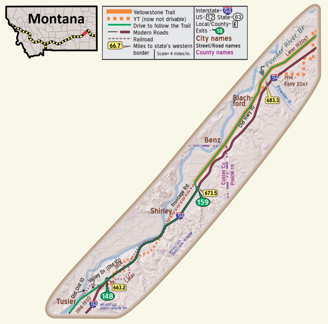 MT-661 to MT-681
Tusler, Shirley, Benz, Zero, and Blatchford were not towns.
They were names of railroad maintenance stations that were used to identify locations.
MT-683.3 Powder River Bridge
This bridge, or rather the lack of this bridge, played a central role in the machinations of determining the route of the Yellowstone Trail between North Dakota and Miles City, Montana. With the urging and support of the Yellowstone Trail Association, the Powder River Bridge was completed in time to offer a useful route for autoists entering Montana from the east while staying close to the Milwaukee Road tracks, the defining goal of the siting of the Trail. See Trail Tale: Knowlton, page <?>.
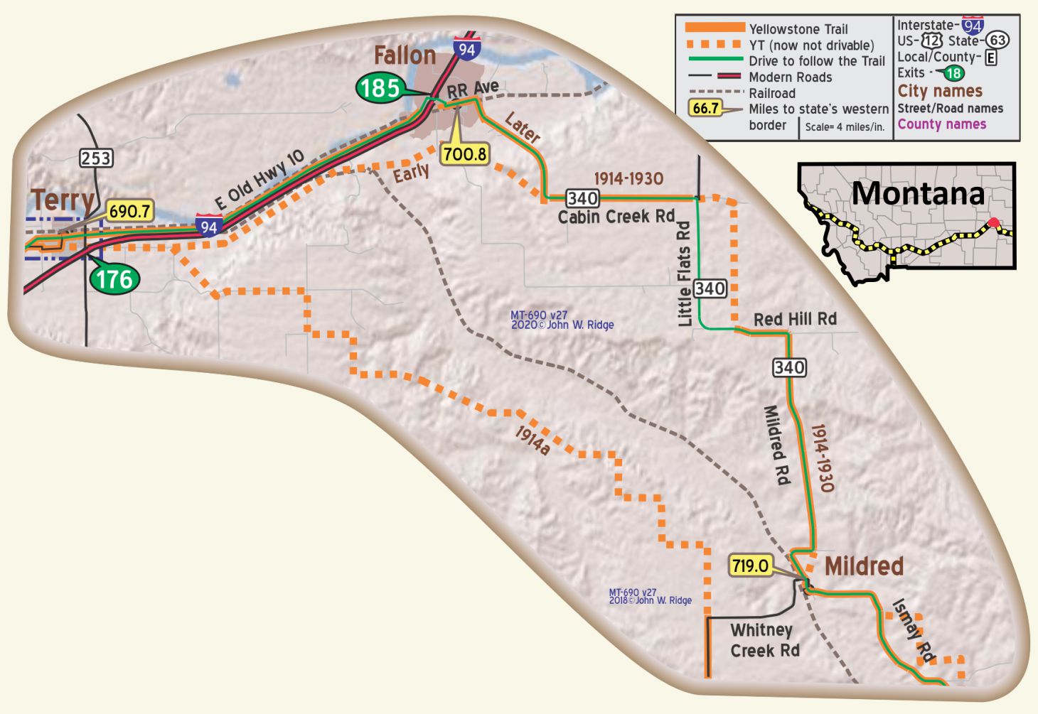 MT-690.7 Terry
KEMPTON HOTEL attractive, clean rooms; nearly all with run. water. Sgl. $1.25-$2.50; dbl. $1.50-$1.75; with bath, $3. Meals 50c. Kempton Hotel Cafe is liked. Kempton camp, has 7 good new cabins with gas plates; $1-$1.50
PATTERSON AND TURNBULL GARAGE is largest and leads by far; splendidly equipped. Ladies’ rest room. Labor $1.25; ph. 73 for wrecker until 12 p. m. MH-1928*
For a dozen miles the highway crosses a dry upland, parched by repeated years of drought. Only the scavenger magpie is at home in this waste. WPA-MT*
Terry was a sheep and cattle shipping station. The Northern Pacific railroad had its own wool house.
101 S Logan St. (Yellowstone Trail). Prairie County Museum is in an historic 1915 bank building which is an antique by itself with beautiful marble floors and rich wood paneling. It probably is the only museum with a steam-heated outhouse out back. Pioneer items of eastern Montana ranching and photos by turn-of-the-century photographer Evelyn Cameron are among its treasures.
There are two sites dedicated to Evelyn Cameron, a famous local photographer, the Gallery and the Heritage Center:
Next to the museum is the Evelyn Cameron Gallery featuring a large photo collection of early eastern Montana, and the interesting story of late 1800s English photographer, Evelyn Cameron. Her candid pictures, taken with a glass plate 5X7 Graflex camera, show a story of rugged range life and beautiful scenery of Montana. Many are on display.
212 Laundre Ave. Evelyn Cameron Heritage, Inc. West of the museum is the Evelyn Cameron Heritage center. Established in 2009, Evelyn Cameron Heritage, Inc. is a non-profit Corporation that actively pursues improving tourism and economic growth by promoting the photographic works and life of Evelyn Cameron. The organization owns over 900 original Evelyn Cameron vintage photographs of the old west; the people, the landscape, the events and more.
See Trail Tale: Cameron, page <?>.
204 Spring St. Kempton Hotel. Built in 1914 and still going today. The historic 1926 neon sign is not easy to miss. The hotel has undergone many remodeling projects in recent years and has earned good reviews. However, apparently there is no central air conditioning. For those inclined for adventure, you might want to stay overnight and chat with the ghosts.
MT-700.8 Fallon
Cattle and sheep cut grass so low that top soil blew away in Dust Bowl years.
Lazy Jo’s Bar and Café on Railway Ave. (Yellowstone Trail) in a 100-year-old building, is across the street from an historic icon, an old water trough. Was it for horses or thirsty Model T radiators?
NOTE from the Ridges: The authors found that the Fallon-Ismay-Plevna route of the YT gives the best way in the U.S. to get the original YT experience. But gas up first.
In Fallon, the newer route of the YT followed Railway Ave. and Co. 340 going south.
Between Terry and Ismay, it may be found that the names of roads differ and conflict from map to map and may be at odds with the few signs on the ground.
Between Terry and Fallon: If old US 10 is open, it is the better route here, rather than I-94. The YT had several routes as the main highway developed in this area and then some fell under I-94. The original route just east of Terry followed Yellowstone St. in town and then Maybon Rd. At some unknown date it moved to Spring St. and Old US 10.
MT-719.0 Mildred
Mildred was once a thriving place with many civic events and tourists passing through. First a cyclone then the railroad moving, then a drought. There are few signs of life there, just a memory of the Yellowstone Trail.
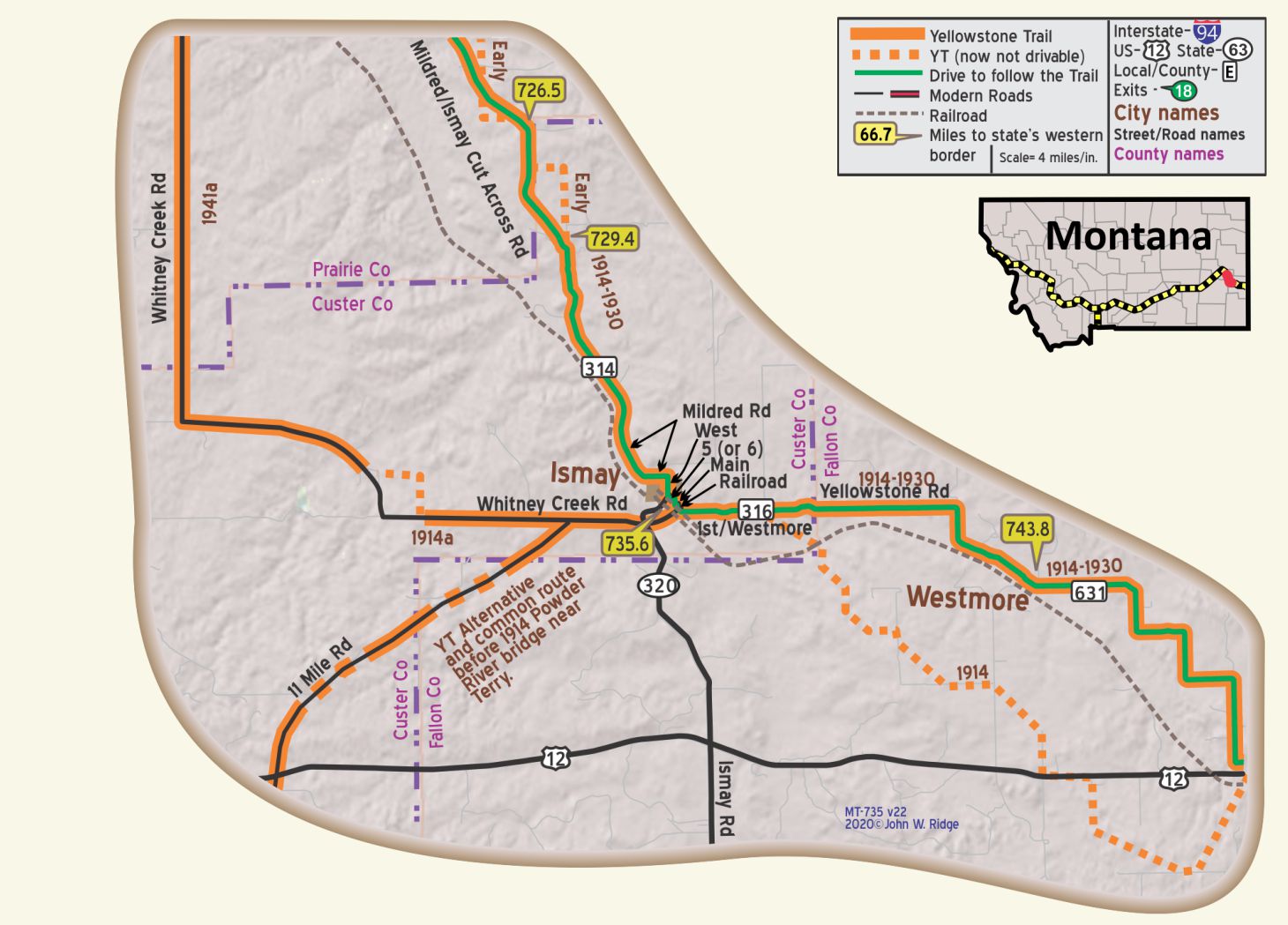 MT-735.6 Ismay
Today one sees a modern fire station, a church, a working grain elevator, and empty lots where once stood a busy, proud town and cattle shipping station. The empty lots bear little signs that named the building that once stood there. Sort of like a cemetery. The Milwaukee Road railroad brought in immigrant farmers and took out herds of cattle to market. Electric street lights came. Autos came. The first radio came in 1922. Then came falling prices, over-extension at the bank and over-dependence on thin, arid topsoil. People moved out. Jonathan Raban in Bad Land (Random House 1996) describes the present Ismay in colorful, almost poetic language the sagging buildings and bleak environment of the little doomed town.
When last we were there, Gene Nemitz was mayor of all 22 citizens (plus or minus). He had an upbeat attitude, mentioning the 20 or so trains rumbling through town from the Bakken oil fields and the possibility of housing oil workers. He runs a successful “cleaning” mill which cleans chaff from wheat seeds which he ships to farmers, seemingly the only business in town. As a publicity lark in the 1990s the town was officially (briefly) named “Joe” after the football player Joe Montana.
As you stand on Main St., 100 feet north of the railroad tracks, look north and you may see the remnants of Judge J. E. Prindle’s fading white frame land office with Mrs. Prindle’s café attached. Prindle was president of the Yellowstone Trail Association in 1913-1914, and a major figure of the town.
Ismay Jail. Walk a bit to the southwest to see the still standing 1910 brick jail, complete with the National Register of Historic Places plaque. It held the “railroad rowdies,” drunks, and those awaiting extradition to Miles City county jail.
MT-743.8 Westmore
You are now in “a silent, empty terrain interacting with the attendant clouds and sky, where austerity gives a clear definition to this arid land.” Maynard Dixon and a Changing West, 1917-1935 by Donald J. Hagerty
The map of the YT between Marmarth and Ismay recorded in the 1914 First Year Book, has many “approximations” and outright fibs or, at least errors, due to poor information. The railroad is straight east of Baker on the map but curves on the ground. Towns are often ½ section off. The alternative line Plevna to Ismay is but a figment of imagination. Hump 3 miles east of Ismay is grossly exaggerated. North of Ismay seems always “off.”
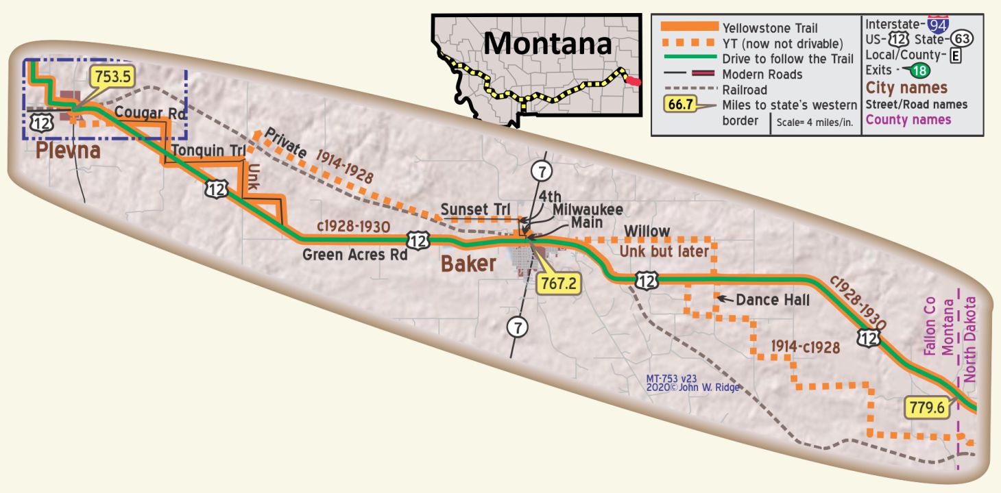 MT-753.5 Plevna
The Custer Country Guide says, “Small towns on the prairie have long been one of Montana’s greatest crops.” That could describe the easternmost 80 miles of Montana – from Fallon to Broadus to the North Dakota line. The plains here in eastern Montana provide a little topographical relief to the eye in the form of cottonwood trees. When you see them you know where the stream is. The grasses move to the wind and you see an immenseness around you.
MT-767.2 Baker
HOTEL BAKER 41 modern rooms; good beds; well maintained. Sgl. $1.50-$2.50; dbl. $2.25; with bath $3.50.
KEIRLE MOTOR CO., Ford; in fine modern bldg.; work on all cars. Labor $1.25; ph. 48.
Note: New road open soon will be much better and shorter. MH-1928*
Natural gas was discovered in eastern Montana in 1915. One still sees many working oil well-head pumps today throughout the area. Eastern Montana is underlain by sedimentary rocks. Sand and silt were carried by rivers from the mountainous west to the east and embedded with swampland vegetation to form vast coal and gas seams.
Begun as a watering station for Milwaukee Road steam trains, Baker was once called the “first Montana city on the Yellowstone Trail” referencing its proximity to the Trail coming out of North Dakota. The town still preserves its history of cattle ranches by printing 88 area ranch brand symbols on restaurant napkins for tourists to see.
723 S Main St. O’Fallon Historical Museum. Displayed in the six-building complex are a 1907 cabin, a claim shack, a 1916 one room school and homestead items. They even have an original metal Yellowstone Trail sign! Part of the
museum is housed in the former jail and sheriff’s living quarters, used as such from 1916 to 1974. Star attraction here is Steer Montana, the 1923 skeleton of the largest steer in Montana. Across the street is the Historical Society’s newish building housing farm machinery, cars, tractors and buggies from the 100-year-old time of the Yellowstone Trail. Parts are on the National Register of Historic Places.
NOTE: An elderly modern citizen from the Baker area reported that the YT followed Willow Rd. just east of Baker. From there, maps begin showing the route to North Dakota to be the modern US 12 route, although some maps seem to significantly miss the actual route. The original stair step route into North Dakota apparently had alternative “steps.” Today some of those roads are used and obscured by the modern oil industry.
When the original Yellowstone Trail arrived in Livingston there was little call for an auto road continuing to the Park;
The Northern Pacific Railroad (NPR) had excellent service there and autos were not allowed in the Park (until 1915).
Headquartered in Glendive, Montana, the NPR Yellowstone Division’s main routes were from
Mandan, North Dakota, to Billings, Montana, and from Billings to Livingston, Montana.
The division encompassed 875 route miles: 546 in main line and 328 in branches.
However, almost immediately,…
Yellowstone Trail tourists from the East and Midwest began agitating to be allowed to use the Livingston-Gardiner wagon road and to be allowed to use their cars in the Park.
The existing wagon road was routed on the west side of the Yellowstone River and ran, generally, along the tracks.
There were many local pressures to have an auto road on the east side of the river, and over the period 1913-1928 such a road slowly took form.
Remember that the route of the Yellowstone Trail was not determined by governmental agencies, but rather by use and, usually, local recommendations for Yellowstone Trail Association action. As bridges were built and roads constructed on the east side, some maps show a gradual movement of the route of the Trail to the east side to promote the use of better and safer roads.
By 1928 the Trail was effectively moved and is now identified as US 89. The west-side route retained the Yellowstone Trail name, however, and today is known formally as the Old Yellowstone Trail. It moved slightly in many places with the construction of new roads and the taking over of the abandoned rail bed, but retains the historical aura.
The first significant leg of the Yellowstone Trail, completed in 1914, stretched 1,100 miles from Minneapolis-St. Paul, to Gardiner, Montana.
WEST SIDE ROUTE TO YELLOWSTONE
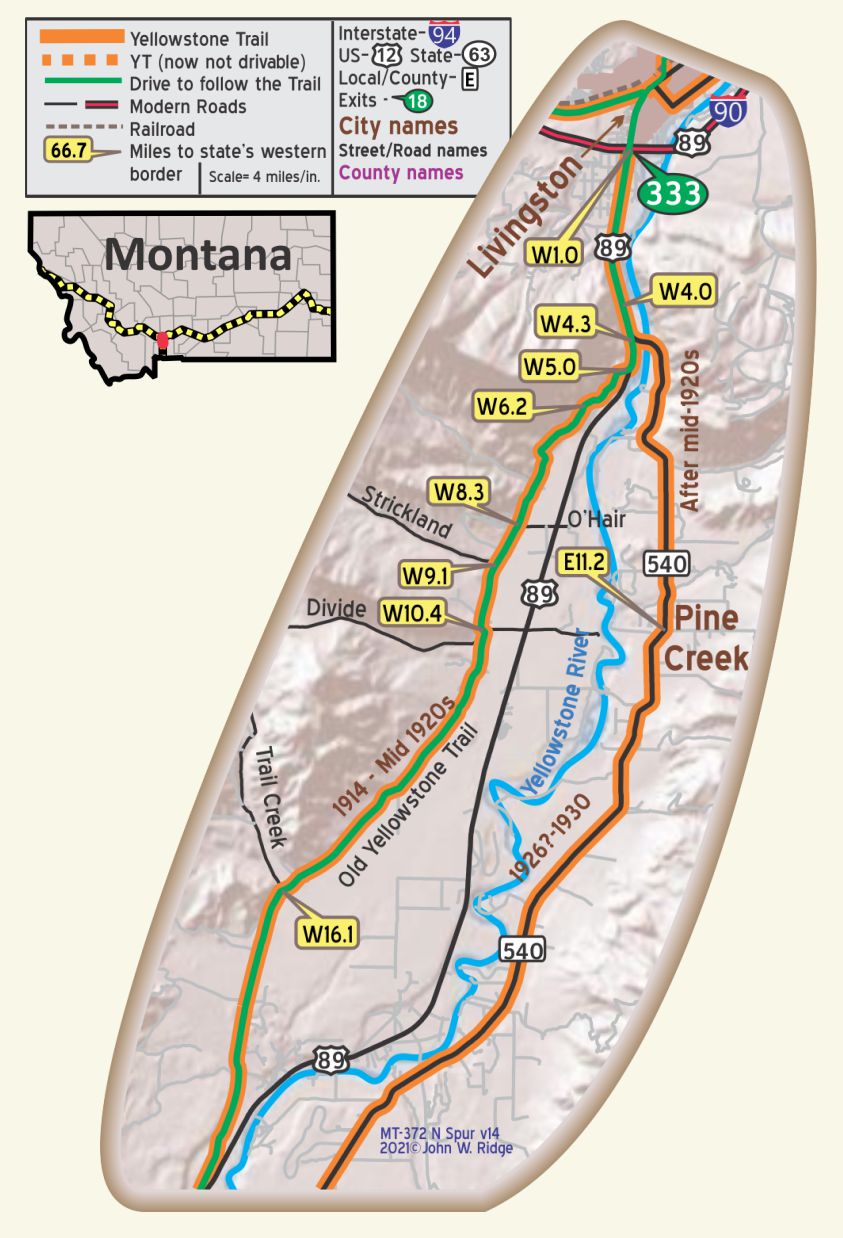 MT-W01.0 At I-90 south of Livingston
MT-W04.3
Intersection with MT 540, the later route of the Yellowstone Trail over Carter Bridge.
MT-W05.0
Junction of US 89 and Yellowstone Trail. There is a hard-to-see sign “old Yellowstone Trail N” on the west side of the road as you leave US 89. Notice Black Mountain and Mt. Cowen, tallest peaks of the Absaroka Range to the east.
MT-W22.1
Junction of Yellowstone Trail and US 89 just north of Emigrant.
MT-W23.0 Emigrant
Emigrant is at the base of pine-clad and snowy Emigrant Peak, 10,960 ft., and on the Yellowstone Trail. Turn west into Emigrant to see the Old Saloon at 210 Railroad Ln. Born in 1902 and out of business for some years, it is now serving three meals a day in an old west atmosphere of cool, dark wood interior.
The Yellowstone Trail is blocked going both north and south due to private property blocking, so you must return to US 89 here.
Early Yellowstone Trail and rail travelers would get to Chico Hot Springs Hotel from here, to the east.

MT-W25.0 Fridley Creek
Just south of Fridley Creek is a driveway to the west. About 400 feet into the driveway is the hard-to-discern Yellowstone Trail and then the railroad grade. Park here. Walk about 400 feet north to find an original small concrete YT bridge and a bigger railroad bridge with a faded YT marker on it – yellow swatch with a hand-drawn arrow. This is private land. We sought and received permission to walk about. Ask permission.
MT-W32.9
Junction of Old Yellowstone Trail and US 89. US 89 to the south crosses Yellowstone River and joins the eastern newer route of the Yellowstone Trail.
MT-W33.9 Point of Rocks
The Yellowstone Trail crosses the Point of Rocks. Great view of the river, old railroad bed, the road and mountains.
MT-W38.1 Miner
Just south of Miner, Tom Miner Creek Road (also National Forest Road 63) heads west for 15 miles to Gallatin Petrified Forest. Here is a layering of 27 or 30 petrified forests lying one on top of another, many of the trees standing. Today you can get a free permit to bring out a bit of petrified wood.
MT-W33.9 Carbella Bridge
Just to the east is Carbella Bridge, nearly 100 years-old.
MT-W39.7-W40.9 Yankee Jim Canyon
Some of the original Yankee Jim road exists today as a hiking path just above the roadway built in 1924 providing a much improved road for the Yellowstone Trail. That route, in turn is just above today’s Old Yellowstone Trail South which had been the Northern Pacific’s track bed. It is this road that was closed by a rock slide in 2016.
MT-W40.72
Park here and walk. A few years ago we were able to drive the original route higher on the hillside. Today, the road follows the railroad grade which is much easier to negotiate. The National Forest Service has erected signs to help guide you through this complex area.
MT-W40.9 Sphinx Creek Interpretive Center (unmanned).
A large interpretive sign describes the river, the railroad, the Yellowstone Trail and Yankee Jim’s road.
MT-W43.7 Cutler Lake
Watch out for the gumbo around here.
MT-W45.9 Royal Teton Ranch
The Church Universal and Triumphant bought 25,000 acres surrounding the Yellowstone Trail and built a compound for members in 1986, calling it Royal Teton Ranch. It is reduced in size with only about 40 people tending the remaining acres where quarterly retreats are held. It was considered a Domesday cult by many.
MT-W47.0 Bridge to Corwin Springs
The bridge to Corwin Springs, built in 2007, is uninteresting as a bridge. It replaced the old but interesting through truss bridge built in the early 20th century.
MT-W48.34 Devil’s Slide
See that red streak down Cinnebar Mountain? That “Devil’s Slide” marks the place where a coal stream burned out of the Triassic period sedimentary rocks. It is thought that there was more oxygen on Earth 200 million years ago reacting with iron to create the red color. Those “dikes” you see sticking up are stratified rock tipped up on end.
MT-W49.4 Electric (and Aldridge)
Now, at best, archeology sites. At the settlement called Electric was the power plant built to supply electricity to the mines at Aldridge. At the turn of the 20th century, ovens at Electric produced 300-500 tons of coke daily from coal mines in Aldridge. The coke was shipped to Butte and Anaconda smelters to smelt copper ore to make copper wire for the booming telephone and electric wire industries.
MT-W50.4 Yellowstone National Park Boundary (Entrance and Arch are in Gardiner)
MT-W51.6 Cinnabar
Now just an archeology site. Excavations have revealed a blacksmith shop and the location of the railroad depot.
In 1883, the Northern Pacific Railroad built track from Livingston towards Gardiner, the north entrance to Yellowstone National Park. South of Cinnabar a dispute over some property kept it from continuing the last three miles to
Gardiner. Thus, train travelers coming from Livingston were transported from Cinnabar to Gardiner to complete their trip in horse-drawn carriages. While the National Park entrance arch was being built, the Northern Pacific was able to extend the tracks to Gardiner, arriving in 1902, but with “limited services” apparently meaning it lacked a side-track. President Teddy Roosevelt arrived in Gardiner by train to dedicate the unfinished National Park arch in April 1903, but after dropping off the President, the train returned to Cinnabar with the presidential car and the President’s entourage where there was a side track to store it while Roosevelt was in the Park. Thus, Cinnabar claimed to be the capitol of the U.S. from April 8-April 24 while Teddy was in the Park.
MT-W54.0 Tinker’s Hill Cemetery
MT-E54.6 Gardiner
North of the Arch is the Yellowstone Heritage and Research Center. It holds 5.3 million items in its herbarium, archives and archeology lab. You are welcome to conduct research there, however, it is not a museum for the tourist. [Note: The authors helped with moving the items from cramped quarters at Mammoth into the new building. Astounding collections!]
MT-W54.9 (MT-E56.0) Yellowstone National Park Roosevelt Arch
EAST SIDE ROUTE TO YELLOWSTONE
MT-W01.0 At I-90 south of Livingston
MT-W04.6 Carter Bridge
The original Carter Bridge was a toll bridge made of logs built in the early 1880s. This one was built in 1919. The stories of this bridge and many others are told in Montana’s Historic Bridges, 1860-1956 by Jon Axline (Montana Historical Society Press, 2005).
MT-E24.0 Turn off to Chico Rd.
This leads to Chico Hot Springs. Established 1900, it is on the National Register of Historic Places. Originally a hotel, then a medical facility, now it is a resort. It is a an appealing place with a big pool, saloon, hotel, cabins, and out-of-this-world cuisine. See Trail Tale: Chico, page <?>.
MT-E24.6 Murphy Lane to Emigrant
MT-E26.1 Wan-I-Gan
See History Bits about the store that was once here. It was a welcome “home” to many.
MT-E36.1
MT 540 and US 89 join
MT-E48.1 Corwin Springs
Look for a glimpse of what remains of the site of Dr. Corwin’s 1909 elegant Hot Springs Resort Hotel and Natatorium. Hot water was pumped from the LaDuke hot springs 2 miles south. Many came for the believed relief that hot springs afforded the ill.
MT-E55.8+ Gardiner
North of the Arch is the Yellowstone Heritage and Research Center. It holds 5.3 million items in its herbarium, archives and archeology lab. You are welcome to conduct research there, however, it is not a museum for the tourist. [Note: The authors helped with moving the items from cramped quarters at Mammoth into the new building. Astounding collections!]
MT-E56.0 (MT-W54.9)Yellowstone National Park Roosevelt Arch
END OF SPUR SECTION